CHATELAIN, H. - Méthode Pour Etudier La Geographie...
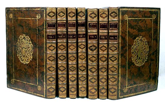
CHATELAIN, H. - Méthode Pour Etudier La Geographie . . . & un Catalogue des Cartes Geographiques, des Relations, Voyages, & Descriptions les plus necessaires pour la Geographie. Amsterdam: Chez Zacharie Châtelain, 1732-1739. 7 volumes, folio. Letterpress titles printed in red and black with engraved vignettes, six half-titles, 7 volumes, folio. in total 6 frontispieces and 287 plates. Contemporary Dutch calf gilt, spines in nine compartments with raised bands, red morocco lettering- piece in the second compartment, lettered directly in the third compartment, the others with repeat decoration in gilt, abstract-patterned endpapers in blue, red, and yellow, red-stained edges.
40.000 $
Amsterdam: Chez Zacharie Châtelain, seven volumes, folio. in total, six frontispieces and 287 plates:
Volume 1 (1739)
frontispiece and 46 plates
Volume 2 (1737)
frontispiece and 37 plates.
Volume 3 (1737)
frontispiece and 30 plates.
Volume 4 (1735) frontispiece and 34 plates
Volume 5 (1732) frontispiece and 57 plates
Volume 6 (1732) 39 plates (counted 1 plate for the large America, which has four sheets that have been completely joined)
Volume 7 (1732)
frontispiece and 44 plates.
Henri Abraham Chatelain, whose Atlas Historique was one of the most expansive encyclopedias of the age. First published in 1705, Chatelain's Atlas Historique was part of an immense seven-volume encyclopedia. Although the text's primary focus was geography, the work also included a wealth of historical, political, and genealogical information.
Nicholas Gueudeville and Garillon compiled the text with a supplement by H.P. de Limiers and the maps were engraved by Chatelain, primarily after charts by Delisle. The atlas was published in Amsterdam between 1705 and 1721 and was later reissued by Zacharie Chatelain between 1732 and 1739.
Chatelain was a skilled artist who knew a wealth of historical and geographical information, with delicate engraving and an uncomplicated composition. Groundbreaking for its time, this work included studies of geography, history, ethnology, heraldry, and cosmography. His maps with his elegant engraving are a superb example of the golden age of French mapmaking.
An ambitious and beautifully presented work, the “Atlas Historique” was intended for the general public, fascinated in the early eighteenth century by the recently conquered colonies and the discoveries. Distant countries, such as those in the Americas, Africa, the Middle East, Mongolia, China, Japan, and Indonesia, play an essential role in this work.
In addition to the maps, many of which are based on Guillaume de l'Isle's work, the plates are accompanied by the best travel accounts of the period, such as those of Dapper, Chardin, de Bruyn, Le Hay, and others.
Other sections deal with the history of European countries, genealogy and heraldry, covering a wide range of subjects including genealogy, history, cosmography, topography, heraldry and chronology, the costume of the world, all illustrated with numerous engraved maps, plates of local inhabitants, and heraldic charts of the lineages of the ruling families of the time. The maps, prints, and tables required to complete a set are listed in detail in each volume.
Henri Abraham Chatelain (1684–1743) was a Huguenot pastor of Parisian origin. He lived consecutively in Paris, St. Martins, London (c. 1710), the Hague (c. 1721), and Amsterdam (c. 1728). The publishing firm of Chatelain, Chatelain Frères and Chatelain & Fils is recorded in Amsterdam, from around 1700-1770, with Zacharias living "op den Dam" in 1730.
New scholarship has suggested the compiler of the atlas, who is identified on the title as "Mr. C***" not to be Henri Abraham Châtelain, but Zacharie Châtelain. (See Van Waning's article in the Journal of the International Map Collectors' Society for persuasive evidence of the latter's authorship.)
The images incorporated into the plates and tables are drawn from the best available contemporary sources, including the works of Dapper, Chardin, de Bruyn, Le Hay, and others. Many of the maps are based on the work of Guillaume de l'Lisle.
Henri Abraham Chatelain (1684-1743), his father Zacharie Chatelain (d.1723), and Zacharie Junior (1690-1754), worked as a partnership publishing the Atlas Historique, Ou Nouvelle Introduction à L'Histoire under several different Chatelain imprints, depending on the Chatelain family partnerships at the time of publication.
The atlas was published in seven volumes between 1705 and 1720, with a second edition appearing in 1732—volumes I-IV with a Third edition and volume I with a final edition in 1739.
The maps were accompanied by information on cosmography, geography, history, chronology, genealogy, topography, heraldry, and costumes from around the world. The maps in the Atlas Historique were mainly based on those of the French cartographer Guillaume De L’Isle, but were presented by the Chatelains in an encyclopedic form. The accompanying text is in French and often is printed in two columns on the page with maps and other illustrations interspersed. Each map and table is numbered consecutively within its volume and all maps bear the privileges of the States of Holland and West-Friesland.
The encyclopedic nature of the work as a whole is reflected in these six frontispieces. The pages are the work of the celebrated mr. Romeijn de Hooghe. and are engraved by J.Goeree, T.Schynyoet and P.Sluyter.
The first volume concerns the ancient world and contemporary Italy, France, and Spain. Eight of the double-page maps depict ancient political and geographical boundaries and locations, as well as city views of Rome. The volume also includes genealogical and historical charts and tables. Two of the maps, Plates 2 and 4, are double-hemisphere world maps that include North America, with California depicted as an island.
Volume VThis volume is devoted to Asia and contains a fine, large folding map of Java and Japan after Reland, as well as a detailed section on China and Japan, accompanied by maps after de l'Isle. The maps in this historical encyclopedia are of interest for their depiction of the East Sea, the sea between Korea and Japan, here referred to as "Mer Orientale ou Mer de Corée". A large portion is devoted to the History of China, including its religious aspects, and mentions the Missionary works of Father Rizzi, among others.
Volume VI
Phillips records 35 maps of American interest, including twelve in vol. VI. The most important of the American interest maps is the "Carte tres curieuse de la Mer du Sud" [Goss North America 52; McLaughlin 190; Wagner 511], which depicts the history of discovery in the western hemisphere from the time of Columbus to the French explorations in North America in the late seventeenth century. Central to the detail is the large depiction of California as an island a somewhat outdated concept at the time of publication and a contrast to the geographically accurate (relatively) delineation of the Great Lakes and the Mississippi.
The Carte Tres Curieuse is also renowned for its illustrations of the New World; beavers are shown at work by Niagara Falls, a fishing factory is in operation in New England, and numerous views of New World cities are also included. Medallion portraits of New World explorers show Columbus, Vespucci, Magellan, Drake, La Salle, and Dampier.
The example in the present set is a fine dark impression on four sheets joined to form a large folding sheet. (As usual, a few tears on crossings of folds have been restored)
References: Koeman II, Cha 1-7 (with variant collation, as usual); Cf. Phillips Atlases 579; Goffart, Historical Atlases, p. 132; van Waning, "Chatelain's Atlas Historique" in Journal of the International Map Collectors' Society, (2010 Spr): 7-15.
New scholarship has suggested the compiler of the atlas, identified on the title as "Mr. C***" not to be Henri Abraham Châtelain, but Zacharie Châtelain. (See Van Waning's article in the Journal of the International Map Collectors' Society for persuasive evidence of the latter's authorship.)
The images incorporated into the plates and tables are drawn from the best available contemporary sources, including the works of Dapper, Chardin, de Bruyn, Le Hay and others. Many of the maps are based on the work of Guillaume de l'Lisle.
