Bunken Edo oezu.
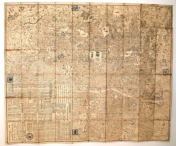
Impressive large-scale plan of Edo (Tokyo, based on map by Ochikochi Doin. Oriented with north to the right. An extraordinary wood block-printed town-plan of today's Tokyo, and a fine example of Edo cartography. The present map is exceptionally detailed with accurate delineations of daimyo residences, temples, shops, private properties, fields, and much more.
Reserved
As is true with all maps of Edo from the Tokugawa period, the site of the Shogunate Castle (located in the center of the map) is left blank -- due in part to security concerns, although this feature clearly enhanced the Emperor's mystique. The large legend includes information on tides, pilgrimage routes, daimyo residences, constellations, distances from Nihonbashi to various places in the City, auspicious and inauspicious days, and more.Oriented with north to the right. Shows land tenures of daimyo and hatamoto, with some crests. Shows main temples and shrines pictorially. Includes legend, distance chart, and texts of seasonal tides.
The first map to bear the above title was published by Suwara Jiemon in 1727: for obvious reasons, the map was revised regularly. The first Kanamaru edition dates from 1778, and it too was revised regularly.
Reference: Edo zu somokuroku / Iwata Hoju. p. 102.
