Composite atlas of the Low Countries by Galle
POR / Inquire
A unique, made-to-order atlas comprising 18 double-page engraved maps by or after Hessel Gerritsz, Theodoor Galle, Jacob van Deventer, Gerard Mercator, Peter Verbiest, Jean Surhon, Claes Janszoon Visscher, Jan Baptist Vrients, David Fabritius, Christiaan 's Grooten, Gerard de Jode and Abraham Ortelius, several dated between 1603 and 1633. Several maps showing traces of careful repair or restoration (occasionally with slight loss of engraved surface at neat lines or at folds). Generally very good condition, with maps in dark impressions.
Provenance: Sotheby's London, 20 October 1988, lot 146. Genesis of the Atlas
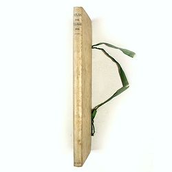
The compiler arranged the atlas in a slim and tall format (445 by 185mm), with each map double-folded to fit inside the tome. This very rare and unusual format was likely designed to make the atlas more compact and more accessible to carry.
The atlas was restored in the middle of the last century and before it was sold at Sotheby's London, 20 October 1988, lot 146.
The maps were laid on paper, bound in a vellum binding, and lettered on the spine in bown ink; "Atlas par Th. Galle 1622".
The atlas is likely compiled between 1633 and 1635. The title on the spine is in French and was likely copied from the original binding.
Provenance: Sotheby's London, 20 October 1988, lot 146. Genesis of the Atlas
In 1612, Theodoor Galle began planning to publish loose-leaf folios of the Netherlands and neighboring regions (Gallia, Germania, Palatinata), with the option for the buyer to compile them into an atlas of the Netherlands.
Galle first published a map of Central Netherlands in two sheets, using the copperplates of the wall map of the Seventeen Provinces of 1605, which the “Officina Plantiniana” purchased after Vrients's death in 1612.
Galle also had the copper plates of Ortelius’s Theatrum and those of De Jode’s Speculum; the “Officina Plantiniana” acquired both sets after Vrients's death in 1612.
In the 1620s, Theodoor Galle added his name to 10 maps of the Ortelius-acquired copper plates. So far, only two Ortelius atlases of the 25 atlases printed by Galle in 1641 have been located.
This atlas must have been compiled after 1633, as the map (10) by Claes Janszoon Visscher: "Caerte van T'Vrye synde been gedeelte van Vlaendren....", is dated 1633. The map was published separately around this date without text on the verso. The map, with text on the verso, was also included in the atlas "Belgicum sive Germania Inferior", by N.J. Picator (Visscher) of 1634.
The compiler arranged the atlas in a slim and tall format (445 by 185mm), with each map double-folded to fit inside the tome. This very rare and unusual format was likely designed to make the atlas more compact and more accessible to carry.
The atlas was restored in the middle of the last century and before it was sold at Sotheby's London, 20 October 1988, lot 146.
The maps were laid on paper, bound in a vellum binding, and lettered on the spine in bown ink; "Atlas par Th. Galle 1622".
The atlas is likely compiled between 1633 and 1635. The title on the spine is in French and was likely copied from the original binding.
In 1635, France allied with the Dutch against Spain, bringing the French into the "Thirty Years' War."
The atlas contains maps of the Low Countries and is extended with maps of Flanders and the German regions of Westphalia and Münster.
With the outbreak of the Thirty Years' War in 1635, the compiler's interest was focused on the regions of battle, the Low Countries, Germany, and France, explaining why the content of maps of the Low Countries is expanded with a map of France, German regions, Flanders, and the Leo Belgiucus map.
The Thirty Years' War:
France avoided direct participation in the Thirty Years' War until May 1635, when it declared war on Spain and the Holy Roman Empire and entered the conflict as an ally of the Dutch Republic and of Sweden. After the Peace of Westphalia in 1648, the war between Spain and France continued. France made some gains in Flanders and along the north-eastern end of the Pyrenees, but by 1658 both sides were financially exhausted, which led them to make peace in November 1659.
Theodoor Galle (1571-1633)
was the son of the Antwerp engraver, publisher and friend of Ortelius, Filips Galle, from whom he learned the art of engraving.
Theodoor spent some time in Italy before settling permanently in Antwerp, where he became an engraver and print-seller.
His marriage to Catharina, the second daughter of Jan Moretus and Martina Plantijn, in 1598 led to a close collaboration with the Plantijn printing house, the publisher of the Ortelius atlas.
Through these family ties, he gained access to the Officina Plantiniana's plate stock. Separate maps bearing Theodoor Galle's imprint are scarce, and composite atlases like this are rarely seen on the market or in institutions.
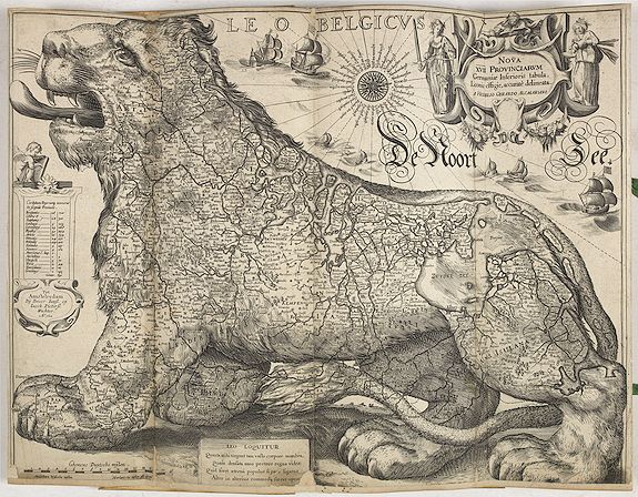
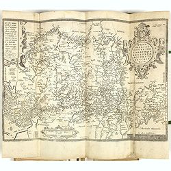
The Leo Belgicus map by Hessel Gerritsz... - Amsterdam, 1622
This early composite atlas includes the only known example of Hessel Gerritsz’ Leo Belgicus map in the third state of the copperplate.
According to Günter Schilder, the first state was likely published by Cornelis Claesz. No example is known.
The Lion Map abounds with historical and political information, whose purpose was to pass on national values and further political and historical consciousness.
The second epigram has three principal elements:
1 - This time, the lion speaks for himself: “Leo loquitur”
2 - The lion’s limbs, the provinces, are truly strong
The Netherlands, depicted as a lion, originated with the Austrian Michael von Aitzing (c. 1530-98), who inserted in his book "De Leone Belgico" (1583) a Leo Belgicus map engraved by Frans Hogenberg. In the preface of this work, von Aitzing explains why he chose this particular title and inserted the lion map.
He explains that Caesar mentioned in his "Commentaries" that the 'Belgae' were the strongest tribes, and he, therefore, decided - partly because of the religious conflicts in the war against Spain - to introduce the Netherlands in the shape of a lion. References: Schilder 7, Van der Heijden, Leo Belgicus, 16.3 Schilder, Monumenta Cartographica Neerlandica, II, pp. 155-159.
1 Hessel Gerritsz: Nova XVII Provinciarum Germaniae Inferioris tabula Leonis effigie, accurate delineata, with the imprint Tot Amstelredam Bij Broer Ianss. En Iacob Pieterss. Wachter A° 1622 (Schilder VII : # 15 copperplate II, third state ; V. d. Heiden, 16.3)
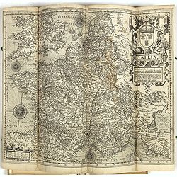
2 Theodore Galle: Gallia. Geographia Galliae description, de integro plurimus in locis.., with Galle's Antwerp imprint, after Pieter Plancius, First ûblished by Vrients in 1606 and after 1612 with the imprint of Theodor Gallaeus. (L. Bagrow, A. Ortelli Catalogus Cartographorum; C. Koeman, Atlantes Neerlandici; Peter H. Meurer, Fontes Cartographici Orteliani 150; M. Van den Broecke, Ortelius Atlas Maps, n. 36.2.)
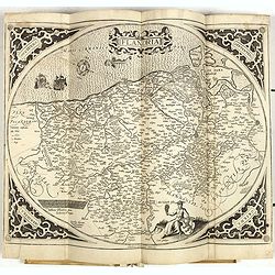
5 Gerard Mercator: Flandriae, without text, and with Galle's imprint,
6 Pieter Verbiest: Comitatus Zeelandiae . . . anno 1633, with the imprint Antverpiae Apud Petrum verbist sub signo Americae in platea quae vulgo Lombardorum moenia dictur,
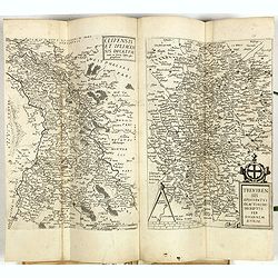
7 Abraham Ortelius: Artois, after Jean Surhon, without text, and with Galle's imprint,
8 Abraham Ortelius: Nobilis Hanoniae comitatus descrip., after Jean Surhon, without text, with Galle's imprint,
9 Abraham Ortelius: Namurcum comitatus, also after Surhon, without, and with Galle's imprint,
10 Claes Janszoon Visscher: Caerte van T'Vrye synde been gedeelte van Vlaendren van nieus gecorrigeert en met vlijt gebetert door Claes Jansz. Visscher A° 1633.
11 Jan Baptist Vrients: Limburgensis Ducatus tabula nova, as issued in the Ortelius Theatrum, from 1603 onwards, without text or imprint,
12 Abraham Ortelius: Lutzenburgensis . . . descript, after Jean Surhon, without text, and with Galle's imprint,
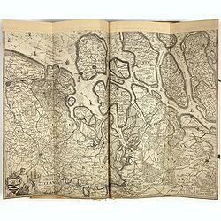
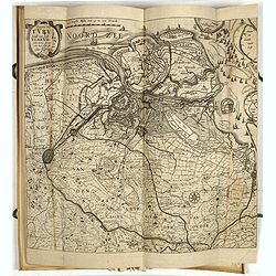
13 David Fabritius: Nieuwe beschrijvinge van Oost en West Vrieslant, issued by Galle, with his imprint,
14 Abraham Ortelius: Lorraine. Lotharingiae nova descriptio, without text, no imprint except for that of Galle,
15 Abraham Ortelius: Gelriae, Cliviae. . . descriptio, after Christiaan's Grooten, without text, and with Galle's imprint,
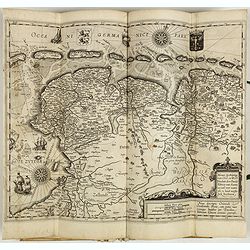
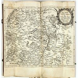
16 Gerard de Jode: Clivensis et Iuliacensis ducatuum, Trevirensis episcopatus, the two maps on one sheet, without text, no Galle imprint,
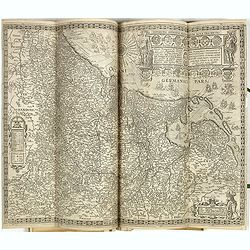
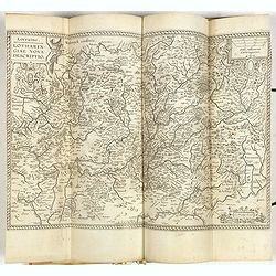
17 Gerard de Jode: Palatinatus Rheni, without text, this copy with the imprint of Galle, however,
18 Abraham Ortelius: Westphaliae . . . descriptio, after Christiaan's Grooten, without text or the Galle imprint.

This early composite atlas includes the only known example of Hessel Gerritsz’ Leo Belgicus map in the third state of the copperplate.
Gerritsz, Hessel. Nova XVII Provinciarum Germaniae Inferioris tabula, Leonis effigie, accurate delineata, amsterdam, 1622.
This "Leo Belgicus-map" by Hessel Gerritsz has the lion passant facing left with North on the right side, placing the city of Brussels on the lion’s left shoulder and Amsterdam near the crest of his back.
This is the only known copy of the third state of copperplate II.
This is the only known copy of the third state of copperplate II.
According to Günter Schilder, the first state was likely published by Cornelis Claesz. No example is known.
The second state issued by David de Meyne (1569 - ca. 1620), came from the property of his colleague-publisher Cornelis Claesz., known to have worked together with Petrus Plancius, and relatively several Plancius’ maps later issued by De Meyne, originally belonged to the list of Corn. Claesz.
This third state (Reference: Van der Heijden, Leo Belgicus, 16.3). is identical to the second one but with the following alterations:- The imprint was changed to “Tot Amsterdam Bij Broer Iansz en Iacob Piertersz. Wachter A° 1622”.
- At the bottom, in a rectangular frame, a new Latin poem: “Leo Loquitur (…)” (“The lion speaks. Just as my huge body has muscular limbs, you can see in my body powerful countries. How good would it be if, united in everlasting peace, each province assisted the others”).
The new Latin poem at the bottom is interesting.
The publishers considered the wording “Leo loquitur” (…)” far more comprehensible to the general reader than the mock scholarly ‘prosopopoeia” (personification).
The publishers considered the wording “Leo loquitur” (…)” far more comprehensible to the general reader than the mock scholarly ‘prosopopoeia” (personification).
A careful comparison of the varying texts of the two epigrams yields further evidence for the map’s emblematic feature.
The first epigram, “Prosopopoeia Leonis Belgici”, dates from the map's birth period around 1608. Both Spain and the Netherlands had exhausted themselves warring against each other, and the Twelve Years’ Truce promised to bring the much-needed period of rest.
The first epigram, “Prosopopoeia Leonis Belgici”, dates from the map's birth period around 1608. Both Spain and the Netherlands had exhausted themselves warring against each other, and the Twelve Years’ Truce promised to bring the much-needed period of rest.
The epigram comprises three elements:
1 - The lion is a personification of the Netherlands
2 - The lion symbolizes bravery and strength, dreaded by all3 - The country yearns for peace, though. Fourteen years later, however, in 1622, when Broer Jansz. reprinted one of the copperplates, the situation had utterly changed.
It became increasingly clear that the Northern Netherlands would win its battle for freedom, but as external threats diminished, internal discord reared its head. The Twelve Years’ Truce was a period of strong internal antagonism.
The princes of Orange wanted to reconquer the Southern Netherlands; the upper middle classes wished for peace so that commerce and prosperity could flourish. Religious dissension was involved in the conflict. Not so much the enemy but factional strife and intrigue beset the country.
1 - This time, the lion speaks for himself: “Leo loquitur”
2 - The lion’s limbs, the provinces, are truly strong
3 – but they should support each other, not fight. Being a true emblem, it serves to admonish and educate.
There are two types of this Leo Belgicus: the 'lion rampant facing right' engraved by Hendrik Floris van Langeren and the 'lion passant facing left' introduced by the engraver Hessel Gerritsz, who masterfully engraved it in copper.
The latter's publication history is complicated, however, and was only unraveled in the course of Van der Heijden's research. What complicates the story is that Hessel Gerritz engraved two almost identical copper plates during the same period, each of which was subsequently published by a series of Amsterdam-based publishing houses.The Netherlands, depicted as a lion, originated with the Austrian Michael von Aitzing (c. 1530-98), who inserted in his book "De Leone Belgico" (1583) a Leo Belgicus map engraved by Frans Hogenberg. In the preface of this work, von Aitzing explains why he chose this particular title and inserted the lion map.
He explains that Caesar mentioned in his "Commentaries" that the 'Belgae' were the strongest tribes, and he, therefore, decided - partly because of the religious conflicts in the war against Spain - to introduce the Netherlands in the shape of a lion. References: Schilder 7, Van der Heijden, Leo Belgicus, 16.3 Schilder, Monumenta Cartographica Neerlandica, II, pp. 155-159.
THE ATLAS
This highly unusual atlas with 18 maps collates as follows:1 Hessel Gerritsz: Nova XVII Provinciarum Germaniae Inferioris tabula Leonis effigie, accurate delineata, with the imprint Tot Amstelredam Bij Broer Ianss. En Iacob Pieterss. Wachter A° 1622 (Schilder VII : # 15 copperplate II, third state ; V. d. Heiden, 16.3)
2 Theodore Galle: Gallia. Geographia Galliae description, de integro plurimus in locis.., with Galle's Antwerp imprint, after Pieter Plancius, First ûblished by Vrients in 1606 and after 1612 with the imprint of Theodor Gallaeus. (L. Bagrow, A. Ortelli Catalogus Cartographorum; C. Koeman, Atlantes Neerlandici; Peter H. Meurer, Fontes Cartographici Orteliani 150; M. Van den Broecke, Ortelius Atlas Maps, n. 36.2.)
3 Theodore Galle: Inferioris Germaniae Provinciarum nova descriptio.
The map represents a reduction of Filip Galle’s wall map of the Seventeen Provinces in twelve sheets, known from the 1606 Vrients edition, now with the imprint of Theodoor Galle.
The only known copy from which the entire imprint of Willem Jansz. has been removed. (Schilder II, p. 167, collection Loeb-Larocque, Paris).
4 Abraham Ortelius: Brabantiae, after Jacob van Deventer's map, without text, and with Galle's Antwerp imprint,5 Gerard Mercator: Flandriae, without text, and with Galle's imprint,
6 Pieter Verbiest: Comitatus Zeelandiae . . . anno 1633, with the imprint Antverpiae Apud Petrum verbist sub signo Americae in platea quae vulgo Lombardorum moenia dictur,
7 Abraham Ortelius: Artois, after Jean Surhon, without text, and with Galle's imprint,
8 Abraham Ortelius: Nobilis Hanoniae comitatus descrip., after Jean Surhon, without text, with Galle's imprint,
9 Abraham Ortelius: Namurcum comitatus, also after Surhon, without, and with Galle's imprint,
10 Claes Janszoon Visscher: Caerte van T'Vrye synde been gedeelte van Vlaendren van nieus gecorrigeert en met vlijt gebetert door Claes Jansz. Visscher A° 1633.
11 Jan Baptist Vrients: Limburgensis Ducatus tabula nova, as issued in the Ortelius Theatrum, from 1603 onwards, without text or imprint,
12 Abraham Ortelius: Lutzenburgensis . . . descript, after Jean Surhon, without text, and with Galle's imprint,
13 David Fabritius: Nieuwe beschrijvinge van Oost en West Vrieslant, issued by Galle, with his imprint,
14 Abraham Ortelius: Lorraine. Lotharingiae nova descriptio, without text, no imprint except for that of Galle,
15 Abraham Ortelius: Gelriae, Cliviae. . . descriptio, after Christiaan's Grooten, without text, and with Galle's imprint,
16 Gerard de Jode: Clivensis et Iuliacensis ducatuum, Trevirensis episcopatus, the two maps on one sheet, without text, no Galle imprint,
17 Gerard de Jode: Palatinatus Rheni, without text, this copy with the imprint of Galle, however,
18 Abraham Ortelius: Westphaliae . . . descriptio, after Christiaan's Grooten, without text or the Galle imprint.
Some of the maps in this atlas
