Browse Listings
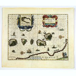
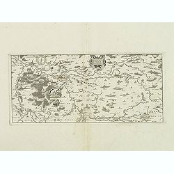
Moluccae Insulae Celeberrimae.
This plate was originally engraved in the 1620, and published as a loose-sheet by Jodocus Hondius II. At his death in August 1629 this map was, among 39 other copper plat...
Date: Amsterdam, 1640
Selling price: ????
Please login to see price!
Sold in 2017
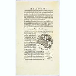
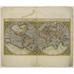
Circumferentia terrae continet miliaria germanica 5400, italica vero 21600.
The map of the Western hemisphere has a banner text "Circumferentia terrae continet miliaria germanica 5400, italica vero 21600". On verso a globe with climates...
Date: Amsterdam, ca. 1640
Selling price: ????
Please login to see price!
Sold in 2023
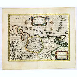
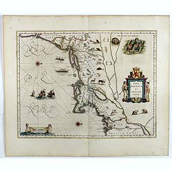
Venezuela cum parte Australi Novae Andalusiae.
Latin text on verso. A finely engraved, decorative map of Venezuela. The islands of Trinidad and Tobago, Margarita, Aruba and Curaçao are shown. Local animals are depict...
Date: Amsterdam, ca. 1640
Selling price: ????
Please login to see price!
Sold in 2017
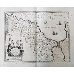
Paraguayo Prov. De Rio De La Plata cum regionibus..
This is an early map showing this northern Patagonia territory. Also showing Rio de Janeiro, Sao Paolo, Santa Cruz of Bolivia, Paraguay, Uruguay, Buenos Ayres, Chilli and...
Date: Amsterdam, ca. 1640
Selling price: ????
Please login to see price!
Sold in 2017
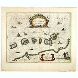
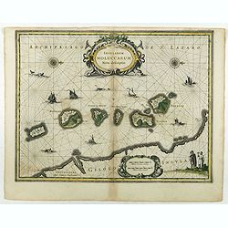
Insularum Moluccarum Nova descriptio.
Exquisite map of the famous Spice Islands based on the islands described by Jan Huyghen van Linschoten.This map was the first large scale map of the region and depicts th...
Date: Amsterdam, 1640
Selling price: ????
Please login to see price!
Sold in 2020
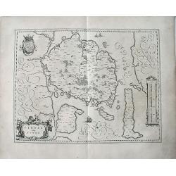
Fionia vulgo Funen.
A very decorative, large map of Funen in Denmark from J. Blaeu. Depicted are Funen, Als and Langeland. With one decorative cartouche and scale.
Date: Amsterdam, 1640
Selling price: ????
Please login to see price!
Sold in 2023
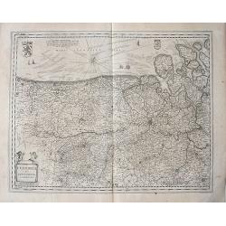
Flandria et Zeelandia Comitatus.
A decorative, large map including Flanders and Zeeland. The map, originally engraved in 1641 for Sanderus 'Flandria Illustrata', was used at different times in Blaeu's va...
Date: Amsterdam, 1640
Selling price: ????
Please login to see price!
Sold in 2018
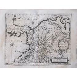
Terra Firma et Novum Regnum Granatense et Popayan.
A very decorative, large, early map of modern-day Panama and Colombia. With Latin text on verso.
Date: Amsterdam, 1640
Selling price: ????
Please login to see price!
Sold in 2018
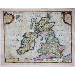
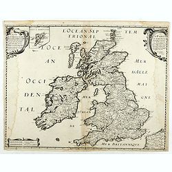
Carte Generale des Royaume d'Angleterre Ecosse et Irlande...
A striking first edition copperplate map of the British Isles by Sanson, on his own slightly eccentric projection. Engraved by Melchior Tavernier in Paris in 1640. Featur...
Date: Paris, 1640
Selling price: ????
Please login to see price!
Sold in 2017
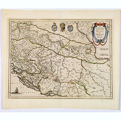
Sclavonia, Croatia, Bosnia cum Dalmatiae parte.
An attractive map of the recently troubled Balkan countries of Bosnia, Croatia & Slovenia, by Blaeu after Gerard Mercator. It was quite unusual for Blaeu to credit Me...
Date: Amsterdam, 1640
Selling price: ????
Please login to see price!
Sold in 2018
Nova Belgica et Anglia Nova.
Orientated with north to the right. This is one of the earliest maps to concentrate solely on this area of the colonies, excluding Virginia and the extreme north east coa...
Date: Amsterdam, 1640
Selling price: ????
Please login to see price!
Sold in 2017
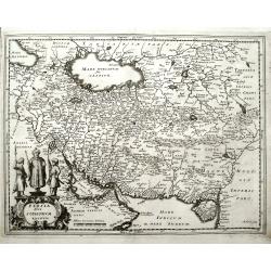
Persia sive Sophorum Regnum.
Merian's decorative and detailed map of Persia, Saudi Arabia, Turkey, the Arab States, the Strait of Hormuz, the Caspian Sea, and extending until the Indus River.
Date: Frankfurt, ca. 1640
Selling price: ????
Please login to see price!
Sold in 2018
Insularum Moluccarum Nova descriptio.
Exquisite map of the famous Spice Islands based on the islands described by Jan Huyghen van Linschoten.This map was the first large scale map of the region and depicts th...
Date: Amsterdam, 1640
Selling price: ????
Please login to see price!
Sold in 2018
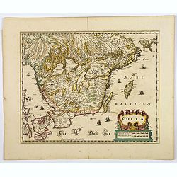
Gothia.
An attractive map of southern part of Sweden including Stockholm, Uppsala, Gothenburg, Malmö. But also Copenhagen and Oslo. A decorative title cartouche and a number of ...
Date: Amsterdam, ca 1640
Selling price: ????
Please login to see price!
Sold in 2020
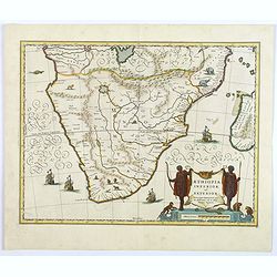
Aethopia Inferior vel Exterior.
A very attractive map of southern Africa depicting the area just prior to the settlement of the Cape Province by the Dutch. The area shown is from the Congo River basin a...
Date: Amstrdam, ca 1640
Selling price: ????
Please login to see price!
Sold in 2019
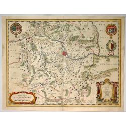
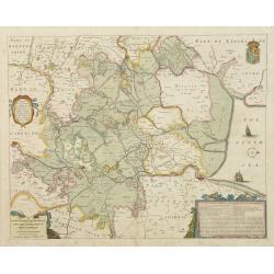
Territorium Metense.
A decorative example of Blaeu's map of the the Metz Region, centered on the city of Metz and the Moselle River. It is a lovely map focusing on the wine region in the Mose...
Date: Amsterdam, 1640
Selling price: ????
Please login to see price!
Sold in 2020
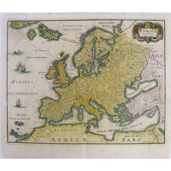
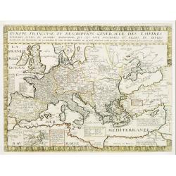
Europa Nova Delineatio.
This lovely map is based on one of the most famous 17th Century maps of the continent of Europe - Blaeu's Europa recens descripta. The map extends to include Iceland and ...
Date: Frankfurt, 1640
Selling price: ????
Please login to see price!
Sold in 2019
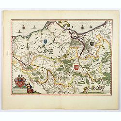
Brandeburgum Marchionatus cum Ducatibus Pomeraniæ et Mekelenburgi.
A highly decorative map of parts of Pomerania, Mecklenburg, Rugia and parts of present day Poland - all with excellent detail of forests, rivers, cities, towns (highlight...
Date: Amsterdam, ca 1640
Selling price: ????
Please login to see price!
Sold in 2019
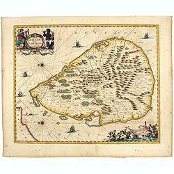
Insula Zeilan olim Taprobana nunc incolis tenarisim.
Janssonius' map of Sri Lanka. Including many VOC settlements and forts, several major town marked with a crown. Very decorative item with two large title and scale cartou...
Date: Amsterdam, 1640
Selling price: ????
Please login to see price!
Sold in 2020
Fezzae et Marocchi Regna Africae Celeberrima, describebat Arab. Ortelius.
A detailed map of Morocco, oriented with north on the right. Showss Morocco, the Kingdom of Fez, the Atlas Mountains, and the coast of Spain. The Strait of Gibraltar is a...
Date: Amsterdam, ca. 1640
Selling price: ????
Please login to see price!
Sold in 2019
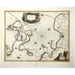
REGIONES SUB POLO ARCTICO.
One of the many cases of duplication by the firms of Blaeu and Hondius/Jansson. In this case, Blaeu has copied Jansson's map of 1637. It depicts rhumb lines radiating fro...
Date: Amsterdam, 1640
Selling price: ????
Please login to see price!
Sold in 2019
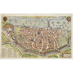
Antverpia
Two joined sheets. Rare bird's eye town-plan of Antwerp.From "Pompa introitus Ferdinandi Austriaci Hispaniarum infantis". The work celebrates the entry of Cardi...
Date: Antwerp, Johannes Meursius, 1641
Selling price: ????
Please login to see price!
Sold in 2012
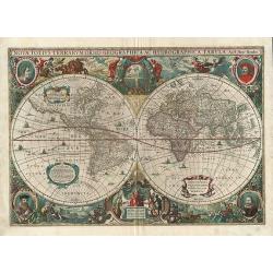
Nova Totius Terrarum Orbis Geographica ac Hydrographica Tabula.
This is Jansson's later edition of Hondius' 1630 superb baroque-style world map. The two hemispheres are boarded with symbols of the four elements, a celestial orb, vario...
Date: Amsterdam, 1641
Selling price: ????
Please login to see price!
Sold in 2012
l'isle de France, Parisiensis Agri de Script.
An attractive map that depicts the region surrounding Paris. There are strap-work title and scale cartouches and a beautiful interlocking border. The high detail depicts ...
Date: Antwerp, 1641
Selling price: ????
Please login to see price!
Sold in 2016
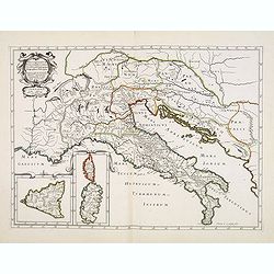
Antiquorum Italiae & Illyrici occidentalis episcopatum geographica descriptio . . .
Scarce map of Ancient Italy and the Adriatic with inset maps of Corsica, Sardinia and Sicily. Engraved by Abraham de la Plaetsen. Included in "Geographia sacra, siue...
Date: Paris, ca. 1641
Selling price: ????
Please login to see price!
Sold in 2014
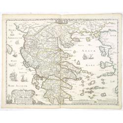
Graeciae Antiquae tabulam hanc geographicam offert, dedicat, consecrat Nic Sanson Abbavillaeus CID DCI XXXVI.
Scarce map of Ancient Greece. Prepared by Nicolas Sanson. In lower right corner "A Paris chez Melchior Tauernier, Graveur et Imprimeur du Roy pour les Cartes Geograp...
Date: Paris, ca. 1641
Selling price: ????
Please login to see price!
Sold in 2013
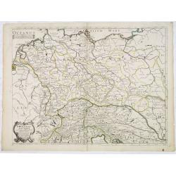
Germania Antiqua.
A fine map of ancient Germany, Poland and the Netherlands.This edition carries the date 1641.The map was prepared by Melchior Tavernier and later published Pierre Mariett...
Date: Paris, 1641
Selling price: ????
Please login to see price!
Sold in 2017
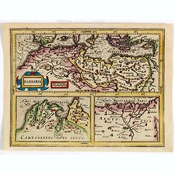
Barbaria./ Egypt/ Tunesia.
Three maps on one sheet. Upper part, it shows the coast of Barbaria from Morocco to Egypt: the map on the left corner of Tunis includes a plan of Goletiae, and the right ...
Date: Amsterdam, 1641
Selling price: ????
Please login to see price!
Sold in 2015
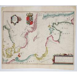
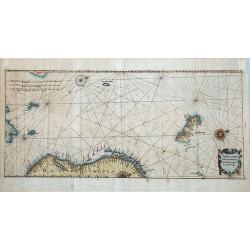
Tabula Navigatoria maris Orientalis...
Rare sea chart of the coasts of Scandinaviachart includes a large coat of arms and two compass roses.
Date: Frankfurt, 1641
Selling price: ????
Please login to see price!
Sold in 2017
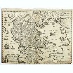
Graeciae Antiquae tabulam hanc geographicam offert, dedicat, consecrat Nic Sanson Abbavillaeus CID DCI XXXVI.
Scarce map of Ancient Greece. Prepared by Nicolas Sanson. In lower right corner "A Paris chez Melchior Tauernier, Graveur et Imprimeur du Roy pour les Cartes Geograp...
Date: Paris, ca. 1641
Selling price: ????
Please login to see price!
Sold in 2018
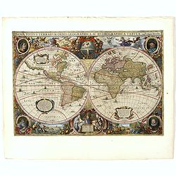
Nova Totius Terrarum Orbis Geographica.
One of the most beautiful world maps ever engraved and one of the most influential in promulgating the California as an island hypothesis and one of the earliest maps to ...
Date: Amsterdam, 1641
Selling price: ????
Please login to see price!
Sold in 2019
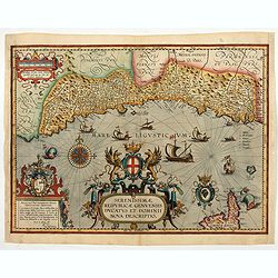
Serenissimae Reipublicae Genuensis Ducatus et Dominii.
Includes the coast of the Riviera from Nice to La Spezia. A most decorative and rare map because it was only included in the Vrients' editions of the Ortelius Theatrum . ...
Date: Antwerp, 1609-1641
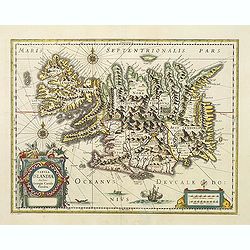
Tabula Islandiae.
A fine map of Iceland. Very attractive title cartouche in the lower left corner: around the island, a ship and two sea monsters are depicted.In spite of it's restorations...
Date: Amsterdam 1641
Selling price: ????
Please login to see price!
Sold in 2016
Gallia Antiqua.
A fine map of ancient France.This edition carries the date 1641.Nicolas Sanson was to bring about the rise of French cartography, although the fierce competition of the D...
Date: Paris 1641
Selling price: ????
Please login to see price!
Sold
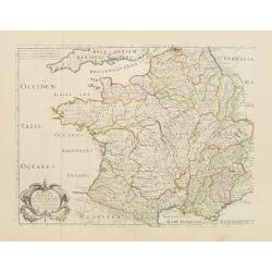
Evrope Francoise Ov Description Generalle Des Empires..
Unrecorded early Canadiana. Rare map of Europe with an inset of Canada or Nouvelle France. The inset has been missed in the bibliographies of North America (not cited in ...
Date: Paris, 1641
Selling price: ????
Please login to see price!
Sold
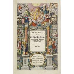
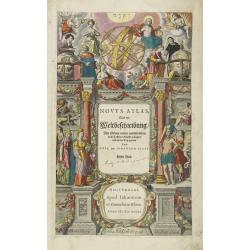
Title page from \"Novus Atlas, Das ist Weltbeschreibung..\".
Attractive title page of Blaeu\'s New Atlas. Highly decorative, and finely engraved architectural façade with figures. Some elements highlighted with gold.The title is p...
Date: Amsterdam, 1641
Selling price: ????
Please login to see price!
Sold
Title page from "Novus Atlas, Das ist Weltbeschreibung..".
Attractive title page of Blaeu's New Atlas. Highly decorative, and finely engraved architectural façade with figures.The title is printed on a paste-on slip and surmount...
Date: Amsterdam, 1641
Selling price: ????
Please login to see price!
Sold in 2008
Tabula Portuum Occidentalium Norwegiae et Spizbergi.
Copper engraving sea chart, printed from 2 plates, by M. Merian from J. A. à Werdenhagen, "De rebus publicis Hanseaticis tractatus". Very decorative cartouche.
Date: Frankfurt, 1641
Selling price: ????
Please login to see price!
Sold in 2018
Irlandiae Mari Portus.
Sea chart of Ireland, from Werdenhagen J., De Rebus Publicis Hanseaticis Tractatus.
Date: Frankfurt, 1641
Selling price: ????
Please login to see price!
Sold in 2009
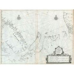
Tabula Portuum Lappiae et Russiae, usq Novam Zembalam.
Scarce sea chart of the Lapland, Russia, Nova Zemlaya and the contiguous arctic seas, from Werdenhagen's De Rebus Publicis Hanseaticis Tractatus.
Date: Frankfurt, 1641
Selling price: ????
Please login to see price!
Sold in 2009
Gallia Antiquae Descriptio, Geographica. . .
An attractive map of ancient Gaul (present day France and Belgium) by the French cartographer Nicolas Sanson, and published by Pierre Mariette. A decorative title cartouc...
Date: Paris, 1641
Selling price: ????
Please login to see price!
Sold in 2010
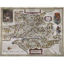
Nova Virginia Tabula.
Early map of Virginia. Being Henricus Hondius' derivative of John Smith's highly important map of Virginia, 1612. Orientation west to top.Title in an Antwerp style cartou...
Date: 1641
Selling price: ????
Please login to see price!
Sold in 2019
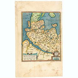
Hassiae Descriptio / Holsatiae Descriptio.
The rare Spanish text edition of 1641 of this important map showing the province of Holstein. Very nice cartouche on the lower left corner with the name of the cartograph...
Date: Antwerp, 1641
Selling price: ????
Please login to see price!
Sold in 2020
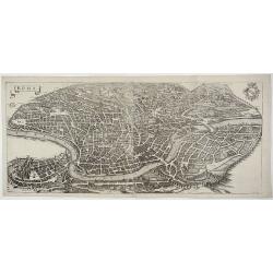
ROMA.
Large and detailed birds eye view of Rome and the Vatican by Matthaus Merian using the late XVI century eastward oriented model which shows the city right after the city�...
Date: Frankfurt, ca. 1642
Selling price: ????
Please login to see price!
Sold in 2019
![[Title page] Novi Atlantis . . .](/uploads/cache/45392-250x250.jpg)
[Title page] Novi Atlantis . . .
A superb and highly decorative title Page from an Atlas issued by Jan Jansson (1588-1664) in 1642, from a German edition of his 'Atlas Novus'.This magnificent page boasts...
Date: Amsterdam 1642
Selling price: ????
Please login to see price!
Sold in 2020
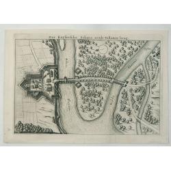
Der Keysersche Schans Aende Tebawer Brug.
A detailed bird’s-eye view of the confluence of the Mulde and Elbe Rivers on the bank of the Elbe. The city of Dessau, Germany is pictured, by Danckerts in 1642.Corneli...
Date: Amsterdam, 1642
Selling price: ????
Please login to see price!
Sold in 2020
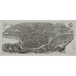
ROMA
A large and detailed birds eye view of Rome and the Vatican by Matthaus Merian using the late XVI century eastward oriented model which shows the city right after the cit...
Date: Frankfurt, ca.1642
Selling price: ????
Please login to see price!
Sold in 2023
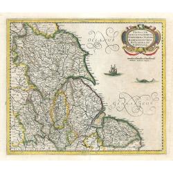
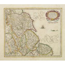
Eboracum, Lincolnia, Derbia, Staffordia, Notinghamia...
An elegant map of northeast England by Henricus Hondius, published out of Amsterdam during the golden age of Dutch map making in 1642. The map presents the English count...
Date: Amsterdam, 1642
Selling price: ????
Please login to see price!
Sold in 2023
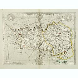
Païs armorique, ou Description de la haute et basse Bretagne, 1642.
Beautiful and rare map of Bretagne published by Boisseau, this edition is without text on the back. Boisseau used the copperplate by Bouguereau. The plate was included in...
Date: Paris, after 1642
Selling price: ????
Please login to see price!
Sold
Carte des environs de la Ferre.
Detailed map of the north of France, of the region of Picardie. Prepared by Claude de Chastillon (1559-1616) and published by Jean Boisseau. Map shows Folembrai, La ferre...
Date: Paris, 1642
Selling price: ????
Please login to see price!
Sold
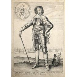
The Right Honourable Robert Earle of Warwick Baron of Leeze etc Lord High Admiral of England One of his Majesties most honourable private Councell & his Majesties Lieutenant of Norfolk & Essex etc
The inscription: 'The Right Honourable Robert Earle of Warwick Baron of Leeze etc Lord High Admiral of England One of his Majesties most honourable private Councell &...
Date: London, 1642
Selling price: ????
Please login to see price!
Sold in 2014

Toonneel des Aerdrycx oft Nievwe Atlas (Title Page)
Fine title page from the Spanish section of the 1642 Blaeu Atlas. A wonderful Title Page from the greatest ever map publishers, "Mapmakers Supreme".The contents...
Date: Amsterdam, 1642
Selling price: ????
Please login to see price!
Sold in 2018
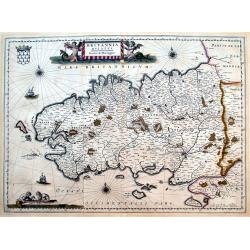
Britannia Ducatus. Duche de Bretaigne.
Early map of Bretagne. Highly detailed, filled with place names. Includes Mont-Saint-Michel, Ile Ouessant, Belle-Ile, and Noirmoutier. Richly decorated with a title carto...
Date: Amsterdam, 1642
Selling price: ????
Please login to see price!
Sold in 2016
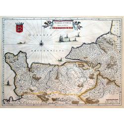
Normandia ducatus.
Very detailed map of Normandy centered on Caen and Rouen. Also showing Cherbourg, Avranches, Bayeux, Cabourg, Honfleur, Le Havre, Etretat, Fecamp. St Malo and Mont Saint ...
Date: Amsterdam, 1642
Selling price: ????
Please login to see price!
Sold in 2016
Carte Generale des Royaume d'Angleterre Escosse et Irlande Avecq les Isles circonvoisines Conues toutes soubs le nom de Britanniques / Nouvellement dressee et tiree de Cambdene Spede & autres Par N. Sanson geogr.e Ord.re du Roy.
Fine example of Nicolas Sanson's first map of the British Isles, engraved by Melchior Tavernier. A small inset map shows the Shetland Isles. The distortion of Ireland and...
Date: Paris, 1642
Selling price: ????
Please login to see price!
Sold in 2018
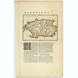
Sardinia Insula.
A small map of the Italian island of Sardinia, printed on a sheet of Dutch text and published in Blaeu's "Theatrum" in 1642. Attractive initial letter 'H' begin...
Date: Amsterdam, ca 1642
Selling price: ????
Please login to see price!
Sold in 2019
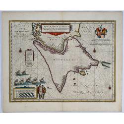
Tabula Magellanica. 

A fine example of W. Blaeu's influential sea chart of Tierra de Fuego with the Strait of Magellan and Le Maire Strait. In original color. Richly arrayed with rhumb lines,...
Date: Amsterdam, 1642
Selling price: ????
Please login to see price!
Sold in 2019
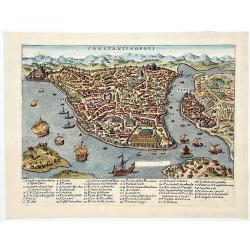
CONSTANTINOPOLI.
A beautiful hand-colored copperplate birds-eye view/map showing Istanbul/Constantinople, with a chart with numbered places-names. Showing multiple ships and buildings. An...
Date: Venice, 1642
Selling price: ????
Please login to see price!
Sold in 2019
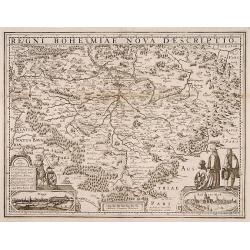
Regni Bohemiae nova descriptio.
Rare map engraved by Petrus Kaerius and published by Evert Cloppenburg.
Date: Amsterdam 1642
Selling price: ????
Please login to see price!
Sold
De gelegenheyt van t'paradys ende t'landt van Canaan. . .
Very attractive map, showing the location of Paradise. Two vignettes depict the Temptation of Adam and Eve, and their Expulsion from the Garden of Eden.
Date: Amsterdam, 1642
Selling price: ????
Please login to see price!
Sold in 2017
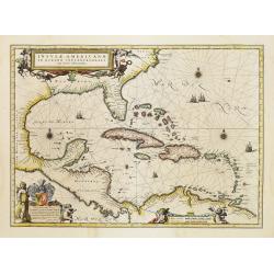
Insulae Americanae in Oceanus Septentrionali cum Terris..
General map of the West Indies extending from Virginia to the mouth of the Orinoco, and destined to be copied in various shapes by many other publishers.Title cartouche t...
Date: Amsterdam 1642
Selling price: ????
Please login to see price!
Sold
Eboracum, Lincolnia, Derbia, Staffordia, Notinghamia..
Showing the north-eastern part of England. Ornamental title cartouche in the upper right corner. Embellished with a vessel and a sea monster.
Date: Amsterdam 1642
Selling price: ????
Please login to see price!
Sold
Westmorlandia Lancastria, Cestria, Caernarvan, Denbigh..
Showing the north-western part of England, including the Island of Man, Liverpool, Blackpool, etc.Embellished with ornamental title cartouche and a vessel.
Date: Amsterdam 1642
Selling price: ????
Please login to see price!
Sold in 2009
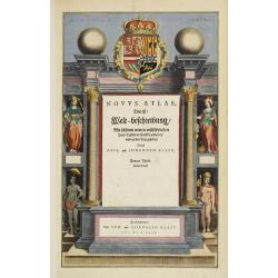
Title page from \"Novus Atlas, Das ist Weltbeschreibung..\".
Attractive title page of Blaeu\'s New Atlas. Decorative and finely engraved architectural façade with figures. Some elements highlighted with gold.The title is printed o...
Date: Amsterdam, 1642
Selling price: ????
Please login to see price!
Sold
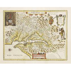
Nova Virginiae Tabula.
The map is based on the first state of Smith's map, 1612, and is slightly larger and more expertly engraved. In 1629 the Hondius plate was purchased by Blaeu who deleted ...
Date: Amsterdam, 1642
Selling price: ????
Please login to see price!
Sold
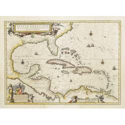
Insulae Americanae in Oceanus Septentrionali cum Terris..
General map of the West Indies extending from Virginia to the mouth of the Orinoco, and destined to be copied in various shapes by many other publishers.Title cartouche t...
Date: Amsterdam, 1642
Selling price: ????
Please login to see price!
Sold
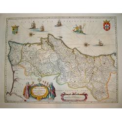
Portugallia et Algarbia uae olim Lusitania.
A popular Blaue map of Portugal, based on the work of Fernao Alvares Seco. Verso text: German. This very detailed map depicts Portugal with numerous ships and Neptune ad...
Date: Amsterdam, ca. 1642
Selling price: ????
Please login to see price!
Sold in 2008
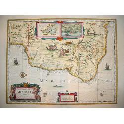
Acuritisima Brasilia Tabula.
A very decorative, desirable map of Brazil. The work is filled with native scenes depicting various activities, including a cannibalism ritual and villagers tending to a ...
Date: Amsterdam, ca. 1642
Selling price: ????
Please login to see price!
Sold in 2008
A general Plott and description of the Fennes..
Fine map depicting the area north of Cambridge, up to King's Lynn. West to the top.
Date: Amsterdam, 1642
Selling price: ????
Please login to see price!
Sold in 2020
Eboracum, Lincolnia, Derbia, Staffordia, Notinghamia..
Showing the north-eastern part of England.
Date: Amsterdam, 1642
Selling price: ????
Please login to see price!
Sold in 2009
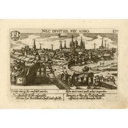
Yperen
Wonderful, miniature copper engraving of Yperen. There is a Latin title at top and the text below the print is in Latin and German. The city of Yperen is shown in the bac...
Date: Frankfurt, ca.1642
Selling price: ????
Please login to see price!
Sold in 2014

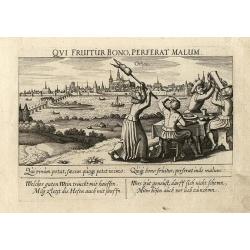
Troye
Wonderful, miniature copper engraving of Troye. There is a Latin title at top and the text below the print is in Latin and German. The city of Troye is shown in the backg...
Date: Frankfurt, ca.1642
Selling price: ????
Please login to see price!
Sold in 2014

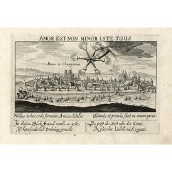
Metz
Wonderful, miniature copper engraving of Metz. There is a Latin title at top and the text below the print is in Latin and German. The city of Metz is shown in the backgro...
Date: Frankfurt, ca.1642
Selling price: ????
Please login to see price!
Sold in 2014
Orleans
Wonderful, miniature copper engraving of Orleans. There is a Latin title at top and the text below the print is in Latin and German. The city of Orleans is shown in the b...
Date: Frankfurt, ca.1642
Selling price: ????
Please login to see price!
Sold in 2014
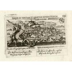
Reims
Wonderful, miniature copper engraving of Reims. There is a Latin title at top and the text below the print is in Latin and German. The city of Reims is shown in the backg...
Date: Frankfurt, ca.1642
Selling price: ????
Please login to see price!
Sold in 2014
Namur
Wonderful, miniature copper engraving of Namen. There is a Latin title at top and the text below the print is in Latin and German. The city of Namen is shown in the backg...
Date: Frankfurt, ca.1642
Selling price: ????
Please login to see price!
Sold in 2014
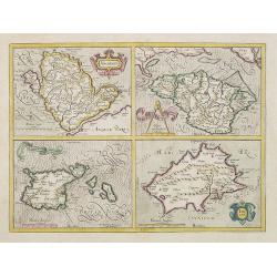
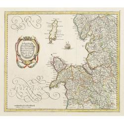
Anglesey. / Iarsay./Garnesay. / Wight Vectis Olim.
Four maps on one sheet depicting the English islands Jersey, Guernsey, Wright and Alderney.
Date: Amsterdam, 1642
Selling price: ????
Please login to see price!
Sold in 2021
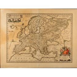
Europam sive Celticam veterem. Sic Describere conabur Abrahamus Ortelius
Historical map of Europe, originally attributed to Ortelius also published in Hondius / Mercator Atlas Novus with different catouches. French text on back.
Date: Amsterdam, 1642
Selling price: ????
Please login to see price!
Sold in 2009
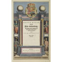
Title page from Blaeu's New Atlas.
Attractive title page of Blaeu's New Atlas. Decorative and finely engraved architectural façade with figures. Some elements highlighted with gold.The title is printed on...
Date: Amsterdam, 1642
Selling price: ????
Please login to see price!
Sold in 2013
![[Two maps] Hiberniae pars Australis. . .](/uploads/cache/08341-250x250.jpg)
[Two maps] Hiberniae pars Australis. . .
Fine two sheet map of Ireland, with impressive topographical information, with several keys. Prepared by Mercator, published by Janssonius / Hondius.Mercator's two-sheet ...
Date: Amsterdam, 1642
Selling price: ????
Please login to see price!
Sold in 2019