Browse Listings
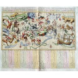
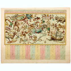
Sterre Kaert of Hemels Pleyn. . .
A fantastic 18th century copper engraved map. This large and unusual Dutch celestial chart shows the constellations of both the northern and southern hemispheres on a sin...
Place & Date: Amsterdam, 1792
Selling price: $510
Sold in 2018
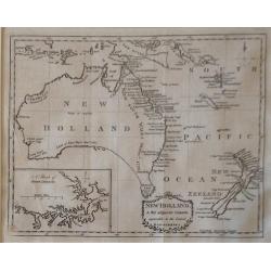
New Holland & the adjacent Islands , agreeable to the Latest Discoveries.
A very fine, rare, important antique 1792 copperplate map with an inset map of 'A Sketch of Port Jackson'. A very detailed period map of what is now called Australia, wit...
Place & Date: London, 1792
Selling price: $750
Sold in 2018
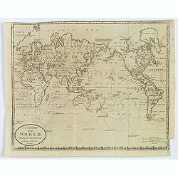
A Chart of the World, shewing the Latest Discoveries of Capt. Cook.
An informative World map, published shortly after Cook's third voyage. It shows the results of Cook's discoveries along the NW Coast of America and in the Pacific. From A...
Place & Date: London, 1792
Selling price: $75
Sold in 2019
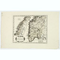
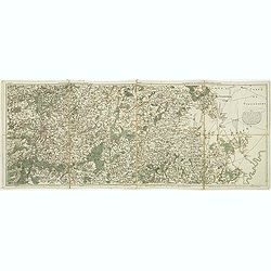
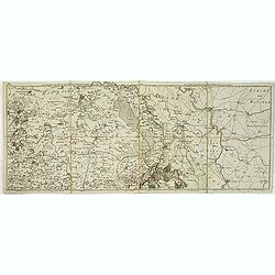
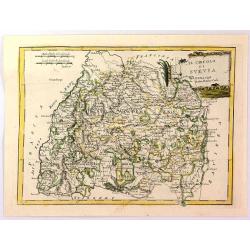
Das Konigreich Norwegen.
Von Reilly's map of Norway, published in the ‘Schauplatz der fünf Theile der Welt, Vienna, 1792. It shows central and southern Norway, with the northern half as an ins...
Place & Date: Vienna, 1792
Selling price: $19
Sold in 2021
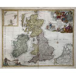
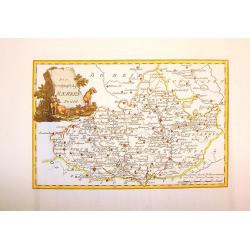
Les Isles Britannique qui contiennent les Royaumes d'Angleterre, Ecosse et Irlande.
A large folio format hand colored copper engraving of Great Britain, with The Netherlands and Belgium also depicted, published in Amsterdam in 1792 by Jan Barent Elwe. Sc...
Place & Date: Amsterdam, 1792
Selling price: $200
Sold in 2019
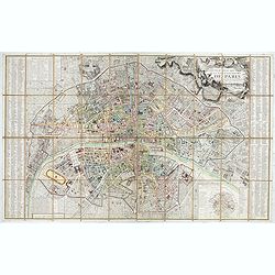
Nouveau plan routier de la ville et faubourgs de Paris Divisé en 48 sections d'après le Décret de l'Assemblée.
Beautiful plan of Paris in original colors. Second edition dated 1792 of five issues published between 1790 and 1797.Title cartouche decorated with a view of the Seine, a...
Place & Date: Paris, 1792
Selling price: $700
Sold in 2020
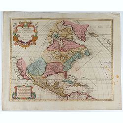
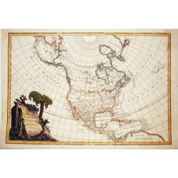
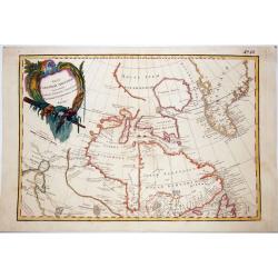
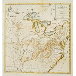
Amerique Septentrionale . . .
Richly embellished map of North America. Based on the Sanson map, which was the first to include all five Great Lakes. California now attached to the mainland. With a lar...
Place & Date: Amsterdam, 1792
Selling price: $400
Sold in 2020
Kurze Erläuterung des Erdbodens...
Scarce atlas with 20 small copper engraved maps. Although anonymous, according to the bibliographer Johann Georg Meusel, the author was Johann Friedrich Hähn. The maps o...
Place & Date: Berlin, 1792
Selling price: $500
Sold in 2020
Sterre kaert of hemels pleyn, waer door men kan wete hoe laet dat het is over de gehele aertkloot, op alle meridiane en polus hoogte . . .
A most attractive Mercator style oblong projection of the entire night sky showing all the heavenly bodies of the northern and southern skies, and with panels of astrolog...
Place & Date: Amsterdam, 1792
Selling price: $500
Sold in 2020
![[10 sheets] Globo Terrestre [and] Globo Celeste.](/uploads/cache/46380-250x250.jpg)
[10 sheets] Globo Terrestre [and] Globo Celeste.
A fine set of hand colored gore sheets for a pair of Cassini 30 cm globes extracted from the Nuovo Atlante Geografico Universale, published from 1790-1801.Cassini's gores...
Place & Date: Rome, 1790-1792
Selling price: $4500
Sold in 2020
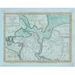
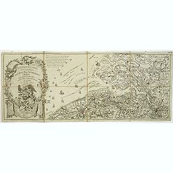
Premiere Revolution de la Mer Caspiernne. . .
One of four maps of the Caspian Sea by Delisle in 1792. This map represents an early period in which the Caspian sea was connected to other known Asiatic waters including...
Place & Date: Paris, 1792
Selling price: $17
Sold in 2023
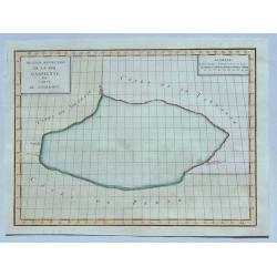
Seconde Revolution de la Mer Caspienne. . .
This map depicts the Caspian Sea according to 2nd century BC Alexandrian geographer Claudius Ptolemy. This map depicts the Caspian Sea surrounded by the coasts of Persia,...
Place & Date: Paris, 1792
Selling price: $1
Sold in 2023
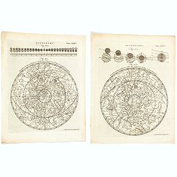
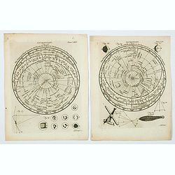
Astronomy - Northern & Southern Hemispheres with the figures of the Constellations.
[Plates LXXXV & LXXXVI] A nice pair of copperplate engravings published by Andrew Bell, a Scottish engraver and printer, who co-founded Encyclopedia Britannica with C...
Place & Date: Edinburgh, ca 1792
Selling price: $36
Sold in 2020
Astronomy. Figures 26 & 29. Plates LXV & LXV.
A lovely pair of copperplate astronomical plates displaying "The Principal fixed Stars in the North Hemisphere [and the South Hemisphere] Delineated on the Plane of ...
Place & Date: London, 1792
Selling price: $12
Sold in 2021
![[Lot of 7 maps of the lands bordering the Red Sea]](/uploads/cache/20680-250x250.jpg)
[Lot of 7 maps of the lands bordering the Red Sea]
Jan Elwe’s re-issue of Guillaume de l’Isle’s 1707 map of the lands bordering the Red Sea, showing Arabia distinctively.Jan Berend Elwe. Amsterdam-based publisher. P...
Place & Date: Paris, 1792
Selling price: $200
Sold in 2022
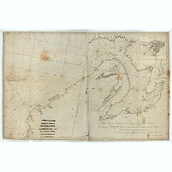
To Her Serene Highness the Empress of all the Russias, This Chart of the White Sea from the North Cape to Archangel and Onega ..
Rare chart dedicated to Catherine II (1729-1796). The chart consists of several inset charts: 1. "A Chart of the River Dwina to Archangel. The Depth of Water in Fe...
Place & Date: London, 1792
Selling price: $210
Sold in 2023

A Family of Charaibes, drawn from the Life, in the Island of St. Vincent.
A lovely and charming engraving of a family, eating, drinking and relaxing on the Caribbean island of St. Vincent. A dwelling is shown, together with local dress, neck be...
Place & Date: London, 1793
Selling price: $22
Sold in 2020
RUSSIAN TEXT MAP - NORTH AMERICA.
A rare Russian, copper engraved map of north America. Based on the second state of the Janvier/Lattre map. It includes the results of Captain Cooks discoveries on America...
Place & Date: St.Petersburg, 1793
Selling price: $750
Sold in 2021
RUSSIAN TEXT MAP - CANADA.
A rare Russian map of western Canada. Based on the Janvier/Lattre map. This Cyrillic version of the map appeared in one of the first world atlases published in Russia; &q...
Place & Date: St.Petersburg, 1793
Selling price: $300
Sold in 2021
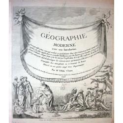
![[Title page for] Géographie moderne avec une introduction. . .](/uploads/cache/47949-250x250.jpg)
[Title page for] Géographie moderne avec une introduction. . .
Engraved title page from Jean Baptiste Louis Clouet (1730-1790) influential "Géographie Moderne" first published in 1767 and reissued in several editions well ...
Place & Date: Paris, 1793
Selling price: $25
Sold in 2022
![[Lot of 2 maps] Afrique divisee en ses principeaux Empires et Royaumes.](/uploads/cache/18439-(2)-250x250.jpg)
[Lot of 2 maps] Afrique divisee en ses principeaux Empires et Royaumes.
This map of the African continent clearly shows the lack of knowledge of the interior of the continent in the 18th century. Only Morocco and Algeria, Egypt, Nubia and Aby...
Place & Date: 1793
Selling price: $220
Sold in 2022
Western Part of the Territories.
A Map of the western part of the territories belonging to the United States of America. Engraved for Imlay's Topographical Description of that Country . Engraved by T. Co...
Place & Date: London 1793
Selling price: $410
Sold
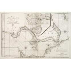
Carte du detroit du Sond contenant les costes de L'Isle de Zélande comprises entre Nicopen et l'Isle de Meun, et celles du Schonen ..
This large scale coastal chart which is oriented so that the west is at the top of the page, shows the north-eastern island of Denmark, Sjaelland on which is located Cope...
Place & Date: Versailles c.1793
Selling price: $150
Sold
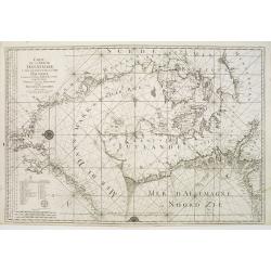
Carte de la Mer de Dannemark et des entrées dans la Mer Baltique contenant les bancs, passes, isles et costes comprises depuis Norden et le Cap Der-Neus ..
A large and detailed nautical chart in Mercator projection, showing the seas surrounding Denmark and between Denmark, Norway and Sweden, from Jacques Nicolas Bellin?s ca....
Place & Date: Versailles c.1793
Selling price: $300
Sold
GÉOGRAPHIE MODERNE
Decorative title page showing sailing ships, puttis with coat of arms, different figures one holding a map another sitting with an Indian.
Place & Date: Paris 1793
Selling price: $40
Sold
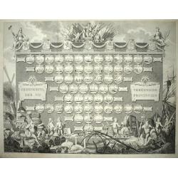
Gedenkzuyl Der VII Vereenigde Provincien.
Large engraving of a "statue" of the 7 provinces of The Netherlands with all the 57 cities sorted per province, below the name of the city in a number the walki...
Place & Date: Amsterdam, 1793
Selling price: $1400
Sold in 2012
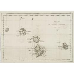
Kaart van de Societeit Eilanden ontdekt door Luit. J. Cook in het jaar 1769. N° 111.
Map of the islands of Maurua, Bolabola, Otaha, Ulietéa and Huaheine. In upper right corner "N° III". As James Cook writes in his journal on page 39 : "So...
Place & Date: Amsterdam, 1793
Selling price: $50
Sold in 2008
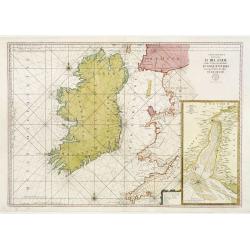
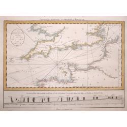
Carte Generale des Costes D\' Irlande, et des Costes Occidentales D\' Angleterre avec une Partie de celles D\' Ecosse.
Large-scale sea chart covering all of Ireland and the western coasts of England, Wales and Scotland. With inset Carte de la Riviere de Dee, ou de Chester depuis son Entr�...
Place & Date: Paris c.1793
Selling price: $300
Sold in 2009
![[Title page] Raccolta di sessanta piu belle vestiture..](/uploads/cache/11832-250x250.jpg)
[Title page] Raccolta di sessanta piu belle vestiture..
Title page from Raccolta di sessanta piu belle vestiture... Very fine, typical Italian title page with putti, etc. Uncommon and decorative.
Place & Date: Napels, 1793
Selling price: $65
Sold in 2018
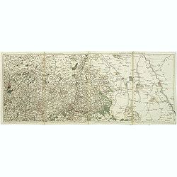
Les environs de Louvain, Tirlemont, . . . Les environs de Limbourg, Bolduc, . . .
Detailed map of Belgium. Showing the cities of Louvain, Liege, Diest, Maastricht and Aix la Chapelle, Cologne, etc. The map was prepared by Jean Baptiste de Bouge (1757-1...
Place & Date: Bruxelles, 1793
Selling price: $55
Sold in 2011
Les environs de Namur, Dinant,. . .Les environs de SPA, Stavelot, . . .
Detailed map of Belgium, showing the cities of Namur, Dinant, Spa, Stavelot. The map was prepared by Jean Baptiste de Bouge (1757-1833), who prepared one of the first ver...
Place & Date: Bruxelles, 1793
Selling price: $9
Sold in 2011
Nouvelle carte chorographique des Pays Bas Autrichiens dédiée aux amateurs des arts. . .
Map of Belgium and Zeeland in the Netherlands. On the left a beautiful title cartouche with putti.The map was prepared by Jean Baptiste de Bouge (1757-1833), who prepared...
Place & Date: Bruxelles, 1793
Selling price: $95
Sold in 2011
Les environs de Bois-le-duc, Breda, Eyndhoven. . .Les environs de Ruremonde, Venlo. . .
Map of Brabant including the cities of Breda, s-Hertogenbosch and Northern Limburg with Venlo and Roermond.The map was prepared by Jean Baptiste de Bouge (1757-1833), who...
Place & Date: Bruxelles, 1793
Selling price: $85
Sold in 2011
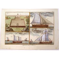
Different Sortes de Peches
Strong copper plate engraving of three sailing fishing vessels. It came from "Encyclopedia Methodique". Engraved and signed in plate by Bernard Direxit. The pu...
Place & Date: Paris, 1793
Selling price: $25
Sold in 2013
Dei Markfraftschaft Maehren, Nro. 114.
Hand-colored copper engraved map of Moravia. Interesting cartouche with three hunting dogs and a rifle. Joseph von Reilly (1766 – 1820) was a Viennese art dealer who t...
Place & Date: Vienna, 1793
Selling price: $17
Sold in 2016
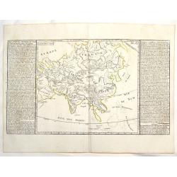
Lacs, Fleuves, Rivieres et Principales Montagnes de L'Asie.
Interesting map of the lakes, rivers and mountains of Asia. Featuring Siberia, India and China. The history of the region is featured to the sides. Published by Mondhare ...
Place & Date: Paris, 1793
Selling price: $15
Sold in 2018
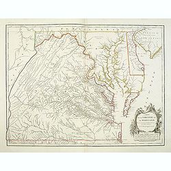
Carte De La Virginie Et Du Maryland Dressee sur la grande carte Angloise de Mrs. Josue Fry et Pierre Jefferson . . . 1755
A state five (of 5). Showing pre-revolutionary war Virginia and Maryland, extending west to the Alleghany Mountains, and including Delaware and a portion of New Jersey, ...
Place & Date: Paris, ca.1793
Selling price: $1200
Sold in 2013
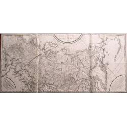
Carte générale de l\'empire de Russie 1787.
Monumental map of Russia. One of the largest maps of the 18th century! Extends from Moscow until Kamtschatka and the border to China. Includes a small part of Alaska. Pub...
Place & Date: Paris, 1793
Selling price: $400
Sold in 2014

Boydell's Shakespeare - Merry Wives of Windsor.
Fine hand-colored engraving from Boydell's Shakespeare Gallery, published in about 1850 in London. Engraved by A. Smith from a painting by R. Smirke featuring a scene fro...
Place & Date: London, 1793
Selling price: $16
Sold in 2019
Il Circulo di Svevia.
"The Circle of Swabia" and below "1793 at Siena Pazzini Carli". The map comes from "Atlante Geografico...", the rare geographical atlas that...
Place & Date: Siena, 1793
Selling price: $10
Sold in 2018
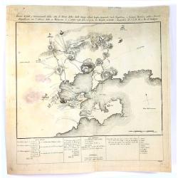
Pianta di Forti, e Trincieramenti Della Vitta di Tolone
A bird’s-eye view of the fort Toulon, France with the surrounding area. The map features the siege of Toulon which took place in 1793. After loyalist royalists had take...
Place & Date: Paris, 1793
Selling price: $20
Sold in 2016
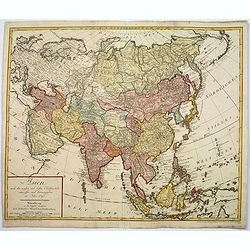
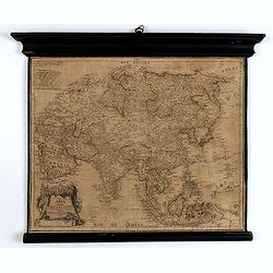
Asien nach den neusten und besten Hülfsmitteln entworffen und herausgegeben im Jahre 1793
Scarce map of Asia with good detail of Indonesia and Philippines, showing New Guinea and the Northern tips of Australia labelled "Neu Holland" and Neu Süd Wall...
Place & Date: Nuremberg, ca 1793
Selling price: $495
Sold in 2017
Les environs de Bois le Duc, Breda. . .Les environs de Ruremonde. . .
Detailed map of Brabant. Showing the cities of Breda, s-Hertogenboch, Eindhoven, Roemond, Venlo, Gueldre etc. The map was prepared by Jean Baptiste de Bouge (1757-1833).
Place & Date: Bruxelles, 1793
Selling price: $132
Sold in 2017
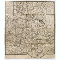
A Topographical plan of Manchester and Salford with the adjacent parts, shewing also the different allotments of land proposed to be built on as communicated to the Surveyor by the respective proprietors. . .
A Topographical plan of Manchester and Salford with the adjacent parts, with inset of a plan of Manchester and Salford and it environs, taken about 1650. The plan shows p...
Place & Date: John Stockdale, London, 1793
Selling price: $450
Sold in 2020
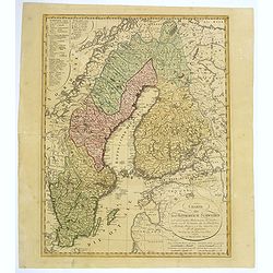
Charte uber das Konigreich Schweden. . .
A detailed map of the Kingdom of Sweden, which until 1809 included Finland, which was then lost to Russia. The original tri-colors of the map are typical of the period. S...
Place & Date: Nuremberg, 1793
Selling price: $110
Sold in 2018
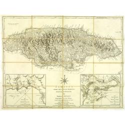
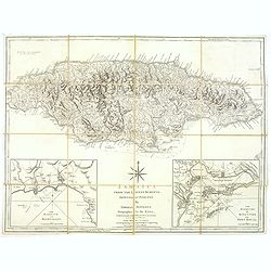
Jamaica from the latest surveys, improved and engraved by Thomas Jefferys. . .
Detailed map of Jamaica, showing parishes, towns and villages, churches, forts, roads, rivers and ponds, harbors, anchorages, soundings, etc.Includes an annotation at upp...
Place & Date: London, 1794
Selling price: $250
Sold in 2012
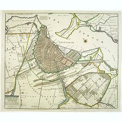
Nieuwe kaart van de Wydberoemde Koopstat Amsteldam . . .
Rare and detailed town-plan of Amsterdam, originally published by P.Mol and 1770, this is the later edition by J. Covens and son, published between 1778 and 1794.Titel in...
Place & Date: Amsterdam, 1778 - 1794
Selling price: $1250
Sold in 2012
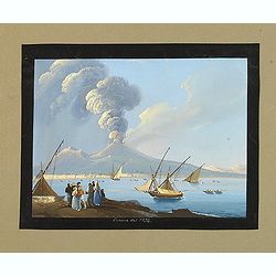
Canera del 1794
Very fine, highly detailed gouache depicting a busy Bay of Naples. Finely executed with boats in the harbor and figures on the shoreline watching the dramatic, fiery erup...
Place & Date: Italy, c.1794
Selling price: $230
Sold in 2012
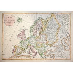
EUROPE, Divided into Principal States. . .
Decorative and highly detailed map of Europe by the famous mathematician Samuel Dunn and published by Laurie & Whittle, 53 Fleet Street London
Place & Date: London, 12th May, 1794
Selling price: $195
Sold in 2015
![[No tittle] Lac salé de Bogdo Montagne de Bogdo.](/uploads/cache/29184-250x250.jpg)
[No tittle] Lac salé de Bogdo Montagne de Bogdo.
Map of Mountains and the Salt Lake of Bogdo in Russia near the border of Kazakhstan, from a second French edition of Peter Simon Pallas' Voyages du Professeur Pallas, dan...
Place & Date: Paris, Maradan, 1794
Selling price: $10
Sold in 2012
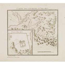
Carte des environs d'Ablaïkit.
Map from a second French edition of Peter Simon Pallas' Voyages du Professeur Pallas, dans Plusieurs Provinces de l’Empire de Russie et dans l’Asie Septentrionale, en...
Place & Date: Paris, Maradan, 1794
Selling price: $10
Sold in 2012
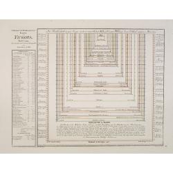
Groessen und Bevoelkerungs Karte von Europa..
A thematic presentation of the sizes of the European countries and their number of inhabitants. From the Grosser Deutscher Atlas published by Franz Joh. Jos. Von Reilly. ...
Place & Date: Vienna 1794
Selling price: $130
Sold in 2012
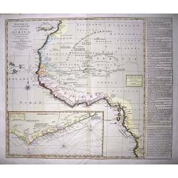
Bowles's new one-sheet map of the coast of Africa :from S.ta Cruz, lat. 30°N. to Angola, lat. 11°.S. with explanatory notes; and a correct chart of the Gold Coast.
Very interesting map of Western Africa, extending from the Canary Islands to Angola. Large scale with much information and interesting annotations. Lists Kingdoms and are...
Place & Date: London, c1794
Selling price: $120
Sold in 2014
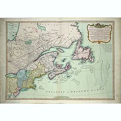
A new and correct map of the British Colonies in North America. . .
Famous map prepared by Gov. Pownall Major Holland. Northern British Colonies, Quebec, New Foundland, Nova Scotia, New England, New York. Including Hudson and James Bays, ...
Place & Date: London, 1794
Selling price: $475
Sold in 2013
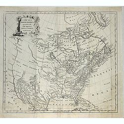
A new map of North America agreeable to the most approved maps and charts. . .
Detailed and uncommon map of North America with the Northwest labeled These Parts Are Entirely Unknown and Land discovered by de L'Isle 1741. Engraved by T.Condor and pub...
Place & Date: London, 1794
Selling price: $300
Sold in 2013
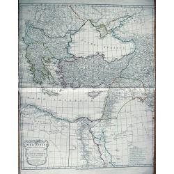
Orbis Romani pars Orientalis
Large map of the Eastern Roman Empire. Extends from Greece to Babylonia, Arabia and Armenia. Includes Thebes in Egypt, the eastern part of the Mediterranean, and the Blac...
Place & Date: London, 1794
Selling price: $66
Sold in 2013
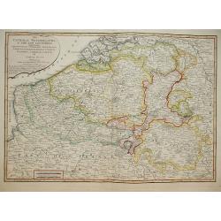
The Catholic Netherlands, or The Low Countries. Comprehending The Provinces of Brabant, Gelderland, Limburg, Luxemburg, Haynaut, Namur, Flanders, Cambre Sis & Artois by Samuel Dunn Mathematician.
A highly detailed map of the Netherlands by Samuel Dunn Published by R. Laurie & J. Whittle No 53 Fleet Street May 1794.
Place & Date: London, 1794
Selling price: $120
Sold in 2014
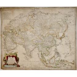
Mapa de Asia : Dividido según la extensión de sus Estados : Formado con los mejores Mapas y documentos nacionales, y sujeto a las observaciones Astronomicas / Por D. Tomás Lopez, Geografo de los Dominios de S.M. de la Academia de S. Fernando
Rare highly detailed map of Asia by Tomás López, from Arabia to tip of Canada and from Russia to Indonesia. In lower left corner, ornate baroque cartouche with animals ...
Place & Date: Madrid, 1794
Selling price: $450
Sold in 2013
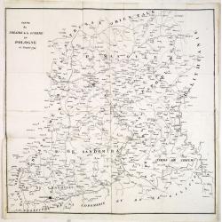
Partie du Théatre de la guerre en Pologne de l'année 1794.
Rare copper engraved map of Poland during the Greater Poland Uprising of 1794. The map is very detailed and also includes battle fields.
Place & Date: Paris, after 1794
Selling price: $150
Sold in 2014
Jamaica from the latest surveys, improved and engraved by Thomas Jefferys. . .
Detailed map of Jamaica, showing parishes, towns and villages, churches, forts, roads, rivers and ponds, harbors, anchorages, soundings, etc.Includes an annotation at upp...
Place & Date: London, 1794
Selling price: $200
Sold in 2018
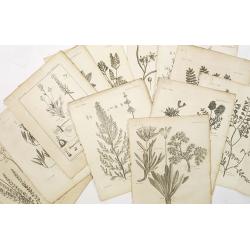
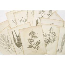
12 engravings of botanical prints : astragalus dasyanthus. . .
12 Engravings from a second French edition of Peter Simon Pallas' Voyages du Professeur Pallas, dans Plusieurs Provinces de l’Empire de Russie et dans l’Asie Septentr...
Place & Date: Paris, Maradan, 1794
Selling price: $100
Sold in 2015
The British Channel including the Coasts of England and France.
The British Channel including the Coasts of England and France by The British Channel including the Coasts of England and France by Thomas Jefferys, published in 1794.T...
Place & Date: London, 1794
Selling price: $115
Sold in 2014
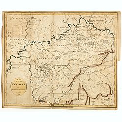
Map of the State of Kentucky with the Adjoining Territory By J. Russell 1794.
Important early map of Kentucky, showing primarily the region around the Ohio and Tennessee Rivers, from northern Georgia to Western Territory. Prepared by John Russell (...
Place & Date: London, H.D. Symonds, 1794
Selling price: $540
Sold
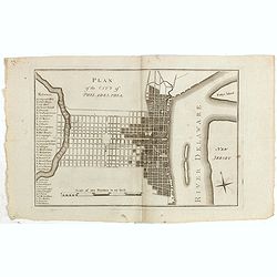
Plan of the city of Philadelphia.
Rare plan of Philadelphia with a lettered key to the important buildings (A. Congress Hall, B. State House C. City Hall, (. . .) W. Bank U.S. X. Bank Penn. Y. Bank N.A., ...
Place & Date: Philadelphia, 1794
Selling price: $1550
Sold in 2015
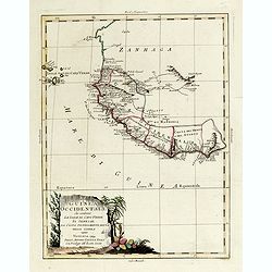
La Guinea Occidentale...
An engraved chart of the coast from Sierra Leone to Cape delle Tre Punte.
Place & Date: Venise, 1794
Selling price: $55
Sold in 2018
12 engravings of botanical prints : Salicorna Foliata. . .
12 Engravings from a second French edition of Peter Simon Pallas' Voyages du Professeur Pallas, dans Plusieurs Provinces de l’Empire de Russie et dans l’Asie Septentr...
Place & Date: Paris, Maradan, 1794
Selling price: $75
Sold in 2015
Mapa de Asia Dividido según la extensión de sus Estados : Formado con los mejores Mapas y documentos nacionales, y sujeto a las observaciones. . .
Fine wall map of Asia from the Black Sea and Arabia to Japan including part of New Guinea. Includes scales. Note: "Se hallará este con las otras partes del Mundo, e...
Place & Date: Madrid, 1794
Selling price: $2000
Sold in 2016
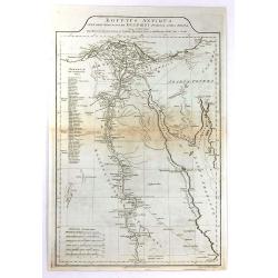
Aegyptus Antiqua Mandato Serenissimi Delphini Publici Juris Facta.
A large detailed map of Ancient Egypt, covering from the Nile Delta and Gaza, southward as far as Aswan. Features both ancient and contemporary place names for each desti...
Place & Date: London, 1794
Selling price: $30
Sold in 2016
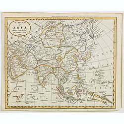
A New Map of Asia, Drawn from the best Authorities 1791.
Attractive map of Asia from "The General Gazetteer or Compendious Geographical Dictionary" by R. Brookes.The map is of interest for the use of Sea of Korea, for...
Place & Date: London, 1794
Selling price: $100
Sold in 2015
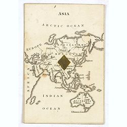
ASIA. (with Australia - Cartographic playing card)
A very rare cartographic playing card (sold as a single, individual card only) featuring an engraved map of Asia and Australia, being the ‘1 of Diamonds’, with one Di...
Place & Date: London, 1794
Selling price: $325
Sold in 2015
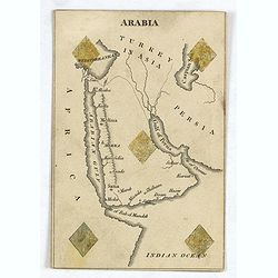
ARABIA ( Cartographic playing card)
A very rare cartographic playing card (sold as a single, individual card only) featuring an engraved map of Arabia, being the ‘5 of Diamonds’, with five Diamonds sten...
Place & Date: London, 1794
Selling price: $250
Sold in 2016
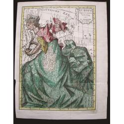
Europa volgens de nieuwste verdeeling.
Uncommon curiosity, depicting Europe as a regal queen but with an interesting twist and political commentary. This anti-Napoleonic image demotes Europa from a virgin-quee...
Place & Date: Haarlem, 1794
Selling price: $350
Sold in 2015
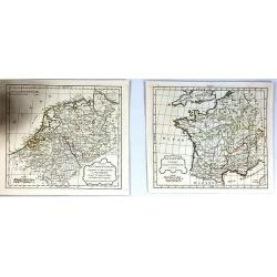
(2 Maps) La Gaule & Partie de L'Empire Francais Royaumes de Hollande, de Westphalie, grand duche de Berg
Two maps of France at different times during their history. They are by Delamarche, the successor of Robert de Vaugondy.
Place & Date: Paris, 1794
Selling price: $15
Sold in 2017
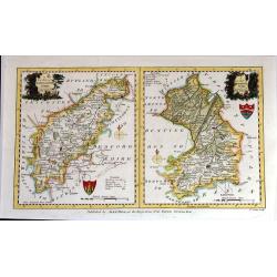
A New Map of Northhamptonshire & Cambridgeshire Drawn from the latest Authorities (Two maps on one page)
Two attached charming and detailed 18th Century county maps engraved by Thomas Condor for “The New And Complete English Traveller” in London. Published by Alexander H...
Place & Date: London, 1794
Selling price: $104
Sold in 2016
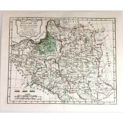
Royaume de Pologne. Par Robert de Vaugondy
Map of Poland and Lithuania by C. F. Delamarche, successor of Robert de Vaugondy, Geographer. With a color key to Russian, Prussian and Austrian possessions.C.F. Delamarc...
Place & Date: Paris, 1794
Selling price: $100
Sold in 2015
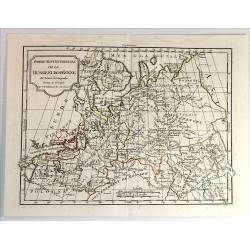
Partie Septenttrionale de la Russie Europeenne par Robert de Vaugondy
Map of European Russia by C. F. Delamarche, successor of Robert de Vaugondy, Geographer. With a color key to Russian, Prussian and Austrian possessions.C.F. Delamarche wa...
Place & Date: Paris, 1794
Selling price: $20
Sold in 2019
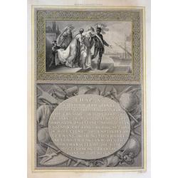
Richard I Leaving Cyprus
A beautifully engraved scene, Richard the 'Lion Heart' is about to board his ship leaving Cyprus in preparation for the Crusade. From Robert Bowyer's edition of Hume's 'H...
Place & Date: London, 1794
Selling price: $95
Sold in 2015
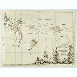
Nuova Guinea e Nuova Galles ed Isole Adjacenti
Map of the South Pacific, showing the sailing routes to the South Pacific by Carteret and Byron, but most importantly, the discoveries made by Captain Cook, 1768-1771. Th...
Place & Date: Venise, 1794
Selling price: $1450
Sold in 2015
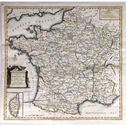
A New and Accurate Map of France, divided into Departments, Districts....
A fine map of France from Spencer's 'History of England'. The title cartouche features the French flag and a military helmet.There is an insert of the Island of Corsica.
Place & Date: London, 1794
Selling price: $15
Sold in 2016
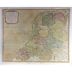
Seat of War in the Seven United Provinces, Comprehending Holland, Zeeland, Utrecht, Gelders, Over-Yssel, Frieseland and Groningen; with the Land of Drant; also Dutch Flanders and Dutch Brabant
An extraordinary 1794 map of the Netherlands, or Holland, by Laurie and Whittle. It features the entire region in extraordinary detail, offering both topographical and po...
Place & Date: London, 1794
Selling price: $125
Sold in 2018