Browse Listings
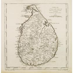
Carte de L'Isle de Ceylan..
A good engraved map of Ceylon. From l'Histoire générale des voyages .
Place & Date: Paris 1750
Selling price: $30
Sold
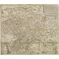
Ducatus Westphalia novâ mappâ Geographicâ..
Map centered on eastern Germany.
Place & Date: Augsburg 1750
Selling price: $40
Sold
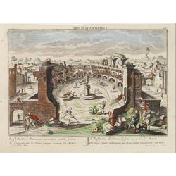
L'Amphitheatre de Rome, sixieme miracle du Monde.
A so-called optical print of the sixth world wonder (Amphi theatre in Rome).In the eighteenth and nineteenth centuries there were many popular speciality establishments i...
Place & Date: Augsburg 1750
Selling price: $220
Sold
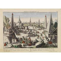
Les Pyramides de l'Egypte, troisieme miracle du Monde.
A so-called optical print of the third world wonder (Pyramids in Egypt).In the eighteenth and nineteenth centuries there were many popular speciality establishments in Pa...
Place & Date: Augsburg 1750
Selling price: $240
Sold
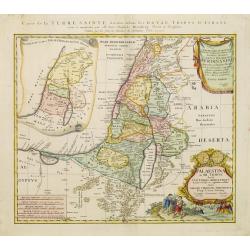
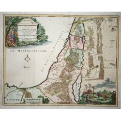
Palaestina in XII. Tribus divisa. . .
Uncommon map of the Holy Land, colored according to the lands of the 12 tribes.Including northern part of Egypt. Prepared by Johannes Christoph Harenberg. With two very l...
Place & Date: Nuremberg, 1750
Selling price: $225
Sold in 2023
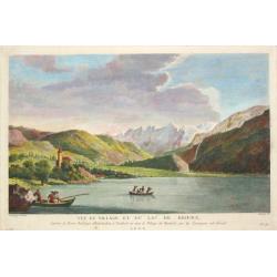
Three very fine views of Switzerland
A view of the village and lake of Brienz. - A view of the village and lake of Lucerne.. - A view of Interlachen. After le Barbier. Together three views in Switzerland.
Place & Date: France, ca. 1750
Selling price: $300
Sold in 2019

Orbis Vetus in utra que continente..
Very decorative large, double-hemisphere map of the ancient world, by the leading French map-maker of the day. In the two cusps are finely engraved cartouches, around the...
Place & Date: Paris 1750
Selling price: $1000
Sold in 2009
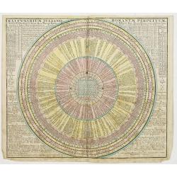
Kalendarium Juliano-Romanum Perpetuum,..
Calendarium.
Place & Date: Augsburg 1750
Selling price: $100
Sold
![[d'Onderdaling der Arke door verscheide betoogingen ondersogt.]](/uploads/cache/22906-250x250.jpg)
[d'Onderdaling der Arke door verscheide betoogingen ondersogt.]
Decorative print focused on the illustration of a vessel. Besides putti are represented playing with simple wooden model ships.Surmounted by putti performing empirical ex...
Place & Date: Amsterdam 1750
Selling price: $20
Sold

Russian Apocalypse
Judgment leaf from a Russian illustrated Apocalypse on paper. It illustrates part of Revelation 9:13-19. "and the sixth angel sounded the trumpet" ... and heard...
Place & Date: Russia, ca. 1750
Selling price: $500
Sold
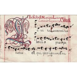
Swiss Gradual Leaf.
A small but attractive music page handwritten in Switzerland in the 1700?s with a large opening initial.
Place & Date: Switzerland, ca. 1750
Selling price: $110
Sold
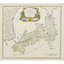
L' Empire Du Japon, divise en sept principales ..
Large map of Japan with a distinctively French style title cartouche containing two small landscapes.The map draws heavily on the previous work of Bellin, but includes a ...
Place & Date: Paris 1750
Selling price: $500
Sold
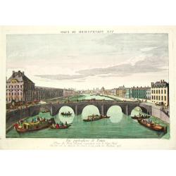
Vue particulierie de Paris. Prise du Pont Royal regardant vers le Pont Neuf. Ou l''on voit les Galeries du Louvre et une partie des Thuilleries cs.
A beautiful optical view of Pont Neuf with the Louvre in Paris.
Place & Date: Paris, c. 1750
Selling price: $180
Sold in 2008
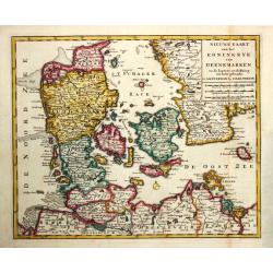
Nieuwe Kaart van het Koninkryk van Deenemarken. 1734
Izaak Tirion (d. 1769) Amsterdam publisher. His ' Nieuwe en beknopte handatlas' saw 6 editions between before 1740 and after 1784. Also ' Tegenwoordige staat van alle vol...
Place & Date: Amsterdam, c. 1750
Selling price: $150
Sold
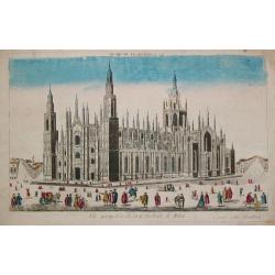
Vue perspective de la Cathedrale de Milan.
An optical view of the Dome of Milan.
Place & Date: Paris, c. 1750
Selling price: $180
Sold
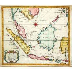
Carte des Isles de Java, Sumatra Borneo & Les Détroits de la Sonde Malaca et Banca Golphe de Siam.
Bellin's map of the Indonesian archipelago, also depicting Malaysia. Jacques Nicolas Bellin (1702-720) was the most important French hydrographer of the 18th century. He ...
Place & Date: Paris, c. 1750
Selling price: $140
Sold in 2019
Brittische Übermacht Zur See wieder Franckreich..
Fascinating and finely engraved map engraved by M.A.Lotter and sold by his father, T.Lotter.It describes naval skirmishes between the British and French during the Seven ...
Place & Date: Paris 1750
Selling price: $450
Sold in 2010
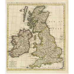
Les Isles Britanniques par Mr. De L'Isle. Geographe du Roy &c.
Uncommon map of the British Isles, after de L'Isle. In lower left bottom : cette carte doit etre placée au commencement des Tomes 2.3.4. & suivans.
Place & Date: Paris ca 1750
Selling price: $75
Sold
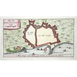
Barcelone
Nice small city plan of Barcelona with the fortification walls. With a few ships in the sea.
Place & Date: ca. 1750
Selling price: $100
Sold
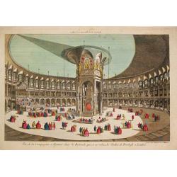
Vue de la Compagnie a déjeuner dans la Rotonde qui est au milieu des Jardins de Renelagh a Londres.
An optical view of a meal held in the Rotonde in Renelagh park in London.
Place & Date: Paris, c. 1750
Selling price: $20
Sold in 2020
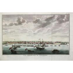
Vuë perspective de Paramaribo.
Attractive view of Paramaribo as seen from the sea, with in the front ships on the roads, to the right fort Zeelandia.
Place & Date: Amsterdam, c. 1750
Selling price: $235
Sold

Vue de l'Interieur de l Église Cathedrale de notre Dame de Paris.
An optical view of the interior of the Notre Dame in Paris.
Place & Date: Paris, c. 1750
Selling price: $100
Sold
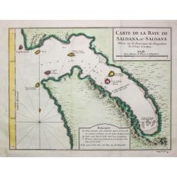
Carte de la Baye de Saldana ou Saldane.
Jaques Nicolas Bellin (1702-720) was the most important French hydrographer of the 18th century. Sea-atlas 'Hydrographique Français' , 1756-65, atlas to accompany Prévo...
Place & Date: Paris, c. 1750
Selling price: $75
Sold in 2020
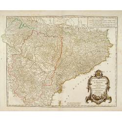
Etats de la Couronne d'Aragon?
Detailed map of a province of Spain. Numerous place-names of counties, cities, towns, physical features.
Place & Date: Paris, c.1750
Selling price: $100
Sold
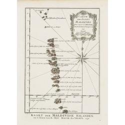
Carte des Isles Maldives.
A very nice map of the Maldives Islands from Atlas Portatif pour servir a l'intelligence de l'Histoire Philosophique et Politique des etablissements et du commerce des Eu...
Place & Date: Amsterdam, 1750
Selling price: $300
Sold in 2018
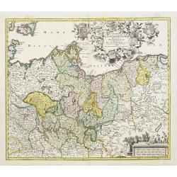
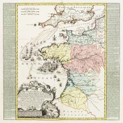
Marchionatus Brandenburgensis Ducatus Pomeraniae et Ducatus Mecklenburgicus..
Seutter's well-engraved map has a large decorative cartouche. Including the towns of Wismar, Stettin, Berlin, etc.
Place & Date: Nuremberg, 1750
Selling price: $250
Sold in 2008
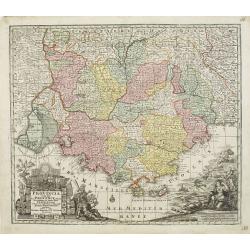
Provincia Gallis la Provence dicta..
Seutter's well-engraved map has two large decorative cartouche. Including the towns of Marseille, Toulouse, St.Tropez, Cannes, Antibes, etc.
Place & Date: Nuremberg 1750
Selling price: $350
Sold
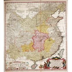
Regni Sinae vel Sinae Propriae Mappa et Descriptio Geographica.
China with the islands of Formosa and Hainan. Copper engraved map in contemporary color after du Halde and d'Anville by John Matth. Hase, published by the heirs of J.-B. ...
Place & Date: Nuremberg, c. 1750
Selling price: $500
Sold in 2013
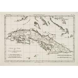
L'Isle de Cuba.
Detailed map of Cuba. Finely engraved with many soundings on banks. Numerous coastal place names. Several tracks noted. The Florida keys and the Bahamas are included.Jacq...
Place & Date: Paris, 1750
Selling price: $110
Sold
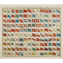
Flaggen aller seefahrenden potenzen und nationen..
A highly decorative and beautiful chart with 140 flags of the sea-faring nations of the world.
Place & Date: Nuremberg 1750
Selling price: $400
Sold
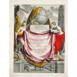
Recueil de Carte sur la Geographie Ancienne.
An attractive title-page of Rigobert Bonne's historical atlas.
Place & Date: Paris, 1750
Selling price: $375
Sold
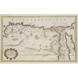
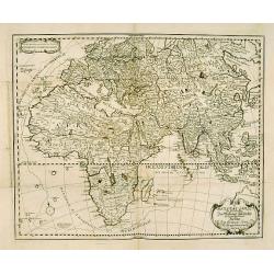
EGYPT an LYBIA.
Map of northern Africa with Egypt, Lybia and Cyrenaica. Nice cartouche at bottom left of map Titled \"EGIPTE,LIBYE,MARMARIKA en CYRENAIKA.\" From the book \&quo...
Place & Date: Amsterdam, ca. 1750
Selling price: $100
Sold in 2008
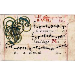
Swiss Gradual Leaf
A small but attractive music page hand written in Switzerland in the 1700?s with a large opening colored initial.
Place & Date: Switzerland, ca. 1750
Selling price: $110
Sold in 2008
Plan de la Ville de Boston.
One of the earliest obtainable town plans of Boston and Charlestown, with an extensive index of 16 specific sites at left, each located on the map. Shows Boston 13 years ...
Place & Date: Paris, 1750
Selling price: $375
Sold in 2008
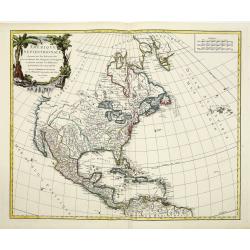
L'AMERIQUE SEPTENTRIONALE Dressée sur les Relations les plus modernes des Voyageurs. . .
Scarce first edition of De Vaugondy's large map of North America. The Coast of California still includes Nlle. Albion, Quiviera and the entrance discovered by Martin d'Au...
Place & Date: Paris, 1750
Selling price: $850
Sold in 2016
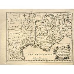
Carte de la route d'Annibal dans les Gaules et de son passage en Italie.
Interesting map showing the route of Hannibal. With south France and Liguria. After a map by Liebaux, a later edition probably from "Histoire Universelle".
Place & Date: Paris, c1750
Selling price: $15
Sold in 2013
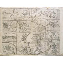
Cities of Ireland (no title).
Sixteen town- plans on one sheet (not numbered): 1:Drogheda, with the battle at the Boyne 2: Londonderry 3:Kinsaile Harbour 4: Chaliamount Fort 5: The city of Dubli...
Place & Date: ca. 1750
Selling price: $239
Sold in 2013
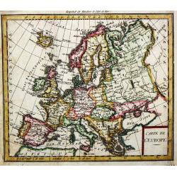
Carte de l'' Europe.
A small map of the European continent.
Place & Date: paris, c. 1750
Selling price: $60
Sold in 2008
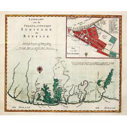
Landkaart van de volkplantingen Suriname en Berbice.
Izaak Tirion (d. 1769) Amsterdam publisher. His '' Nieuwe en beknopte handatlas'' saw 6 editions between before 1740 and after 1784. Also '' Tegenwoordige staat van alle ...
Place & Date: Amsterdam. C. 1750
Selling price: $250
Sold in 2009
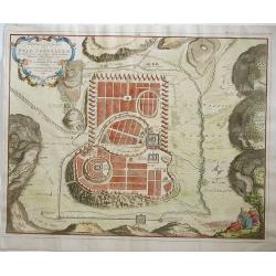
Afbeeldinge der stad Jerusalem..
Great bird's eye plan of the holy city.
Place & Date: Gorinchem, 1750
Selling price: $225
Sold in 2008
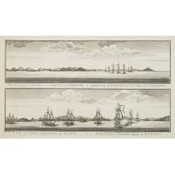
Vue de la Pointe du Nord-Est de l'Isle Sainte Catherine / Gezigt van de Noord-Oost Punt van 't Eiland S. Catharina.
From a Dutch edition of a voyage account. Large size (41 x 27 cm). Showing two views of the Island S. Catharina near Brazil, with ships.
Place & Date: Amsterdam, c. 1750
Selling price: $210
Sold in 2008
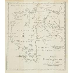
Karte von Hudsons Meerenge und Meer Busen.
Map of the Hudson Bay.
Place & Date: Goettingen : A. Vandenhoeck, 1750
Selling price: $75
Sold in 2023
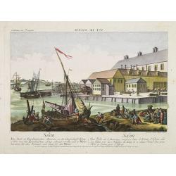
Vue de Salem. (reversed
A so-called optical print. A lively scene from the harbour of Salem with many people loading a vessel. Engraver: Balthazar Frederic Leizelt.
Place & Date: Augsburg 1750
Selling price: $200
Sold in 2008
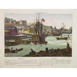
Vue de Quebeck.
A so-called optical print showing a decorative view of the town seen from the harbour, with a large vessel in the foreground. Engraved by Balthasar Frederic Leizelt.
Place & Date: Augsburg, 1750
Selling price: $160
Sold in 2008
Vue de Siam avec diverses Sortes des Ballons, ou Vaisseaux Chinoise a Rame.
Optical print with view of Thailand.A so-called optical print. In the eighteenth and nineteenth centuries there were many popular speciality establishments in Paris, Augs...
Place & Date: Augsburg, 1750
Selling price: $325
Sold in 2008
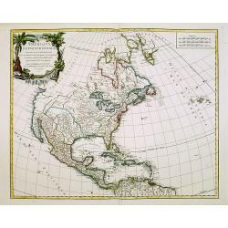
L'AMERIQUE SEPTENTRIONALE Dressée sur les Relations les plus modernes des Voyageurs. . .
Scarce first edition of De Vaugondy's large map of North America. The Coast of California still includes Nlle. Albion, Quiviera and the entrance discovered by Martin d'Au...
Place & Date: Paris, 1750
Selling price: $425
Sold in 2008
General Karte zur erleuterung der Missions-Geschichte..
Fine map of the eastern hemisphere with Europe, Africa, Asia and tip of Australia (Nova Hollandia). With an unusually curved Korea. Including a over-sized I.Formosa Text ...
Place & Date: Germany c. 1750
Selling price: $480
Sold
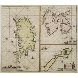
Paskaart van Ysland Spitsberge en Jan Mayen Eyland. . .
Three charts on one sheet. In the left hand part of the page a chart of Iceland. To the upper right "Spitsbergen" and lower right "Jan Mayen Island".P...
Place & Date: Amsterdam, ca.1750
Selling price: $1700
Sold in 2016
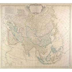
Carte de L'Asie dressée sur les Relations les plus . . .
Large map of Asia from Robert de Vaugondy\'s Atlas Universel. We see major political divisions and the state of European knowledge of the continent in the mid-18th centu...
Place & Date: Paris, 1750
Selling price: $375
Sold in 2009
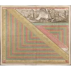
Germaniae Aliorumque Quorundam Loco-rum Europae Poliometria
Distance table from L.C. Lotter, with nice cartouche and explanation of usage.
Place & Date: Augsbourg, 1750
Selling price: $140
Sold in 2009
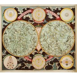
Planisphaerium Coeleste.
This decorative and rare, boldly-engraved double hemisphere map illustrates north and south polar hemispheres, with smaller circular diagrams showing the Ptolemaic, Tycho...
Place & Date: Amsterdam, 1750
Selling price: $2500
Sold in 2017
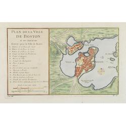
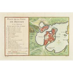
Plan de la Ville de Boston et ses Environs.
One of the earliest obtainable town town-plan of Boston and Charlestown, with an extensive index of 16 specific sites at left, each located on the map. Shows Boston 13 ye...
Place & Date: Paris, 1750
Selling price: $400
Sold in 2015
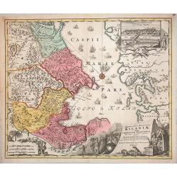
Provinciarum Persicarum Kilaniae nempe Chirvaniae Dagestaniae.
Very decorative map of the southern part of the Caspian Sea, Caucasus and Turkmenistan, by J B. Homann. A nice view of the city of Baku (the former Tereki) in a decorativ...
Place & Date: Nuremberg, 1750
Selling price: $400
Sold in 2013
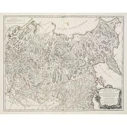
Partie Orientale de l'Empire de Russie en Asie . . . la Tartarie Chinoise . . .
Map of the Asian part of the Russian Empire and the Tartary region, including Sakhalin and Kamchatka..Tartary was a name used by Europeans from the Middle Ages until the ...
Place & Date: Paris, 1750
Selling price: $170
Sold in 2013
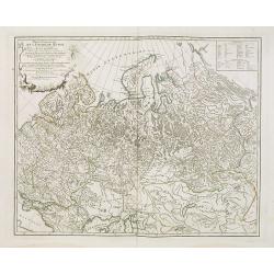
Partie Occidentale de l'Empire de Russie . . .
Map of the western part of the Russian Empire, north of the Black Sea and the Caspian Sea, Nova Zembla, including most of Finland.
Place & Date: Paris, ca. 1750
Selling price: $160
Sold in 2009
Afbeelding van 'T Joodsche Land..
This attractive map from a large Dutch Bible shows the land of Israel with all the places, rivers, mountains, and seas mentioned in the Holy Scriptures. It covers all of ...
Place & Date: Gorinchem, 1750
Selling price: $200
Sold in 2009
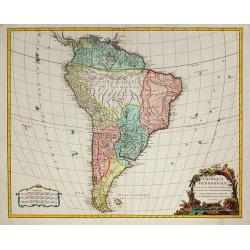
Amérique Méridionale, dressée, sur les Mémoires les plus récents . . .
South America, dated 1750, providing a clear summary of European knowledge at the time. From the Atlas Universel.
Place & Date: Paris, 1750
Selling price: $275
Sold in 2010
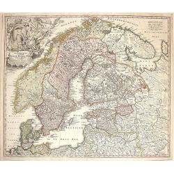
Scandinavia complectens Sueciae, Danaie & Norvegiae Regna.
Map of Scandinavia centerd on Sweden, Norway and Denmark.
Place & Date: Nuremberg, 1750
Selling price: $200
Sold in 2009
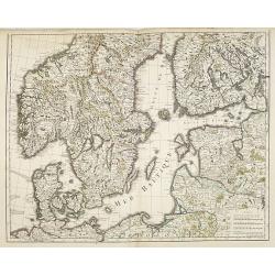
Mer Baltique - Golfe de Bothnie.
The map is centered on the Baltic Sea, including Denmark, Finland, a part of Poland, and southern parts of Norway and Sweden. Engraved by Liébaux le fils.
Place & Date: Paris, 1750
Selling price: $210
Sold in 2009
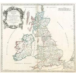
Britannicae, Insulae in quibus Albion sen Britannia Major, ...
British Isles by de Vaugondy.
Place & Date: Paris, 1750
Selling price: $60
Sold in 2009
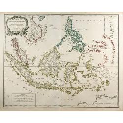
Archipel Des Indes Orientales, qui comprend Les Isles De La Sonde ... Philippines ...
An attractive and detailed view of the Indonesian islands in large format. Decorative title cartouche.
Place & Date: Paris, 1750
Selling price: $520
Sold in 2009
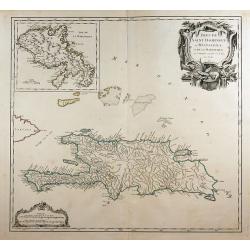
Isles de Saint Domingue ou Hispaniola, ...
A large map of Santo Domingo, with an inset showing the island of Martinique.
Place & Date: Paris, 1750
Selling price: $150
Sold in 2011

Lilio Narcissus Hemerocalli disfacie.
Copper engraving. Issue with the text on verso, handcolored very skillfully at a later date.Plate 14 published in the Hortus Eystettensis . Without doubt one of the great...
Place & Date: Eichstätt ca. 1713-1750
Selling price: $1100
Sold in 2009
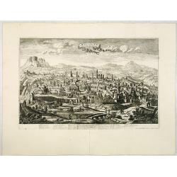
Jerusalem comme elle est a present.
A very decorative and extremely rare of Jerusalem, including a numbered (1-36) key in lower part. Published by Jacques Chéreau, (1688 - 1776). Engraved by Aveline and f...
Place & Date: Paris, ca.1750
Selling price: $2900
Sold in 2013
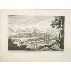
Florence. Florence Ville d'Tialie, capitale de Toscane. . .
A very decorative and extremely rare town-view of Florence, in Tuscany. Including a 4-line text in lower part. Published by Jacques Chéreau, (1688 - 1776). Engraved by A...
Place & Date: Paris, ca.1750
Selling price: $2200
Sold in 2016
Genes. Ville Capitale de la Republique de meme nom seituée sur la mer méditerranée en Italie.
A very decorative and extremely rare of Genoa, including a numbered key ( 1-30 ) in lower part. Published by Jacques Chéreau, (1688 - 1776). Engraved by Aveline and fir...
Place & Date: Paris, ca.1750
Selling price: $3500
Sold in 2012
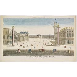
Vue de la Place de S.Marc à Venise.
Showing the St.Marco Square in Venice. Mondhard was a well-known publisher of optical prints, established in rue St.Martin in Paris. In the eighteenth and nineteenth cent...
Place & Date: Paris, ca. 1750
Selling price: $100
Sold in 2009
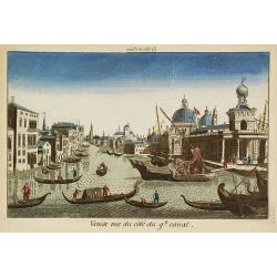
Venise vue du côté du g(rann)d canal.
Showing the Grand Canal in Venice. Likely published by Mondhard, a well-known publisher of optical prints, established in rue St.Martin in Paris. In the eighteenth and ni...
Place & Date: Paris, ca. 1750
Selling price: $110
Sold in 2009
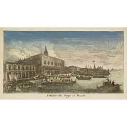
Palais du Doge à Venise.
Showing the Doge's Palace in Venice. Likely published by Mondhard, who was a well-known publisher of optical prints, established in rue St.Martin in Paris. In the eightee...
Place & Date: Paris, ca. 1750
Selling price: $100
Sold in 2012
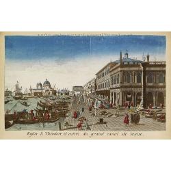
Eglise S.Théodore et entrée du grand canal de Venise.
Showing the entrance of the Grand Canal in Venice. Likely published by Mondhard, who was a well-known publisher of optical prints, established in rue St.Martin in Paris. ...
Place & Date: Paris, ca. 1750
Selling price: $100
Sold in 2013
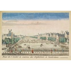
Pont de l'Amstel et maison des orphelines à Amsterdam.
Showing the Amstel bridge in Amsterdam. Likely published by Mondhard, who was a well-known publisher of optical prints, established in rue St.Martin in Paris. In the eigh...
Place & Date: Paris, ca. 1750
Selling price: $150
Sold in 2011
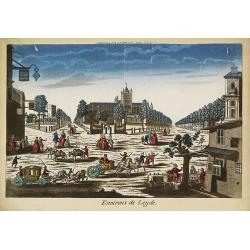
Environs de Leijde. (Vue des environs de Leyden)
Showing the market square in Leiden. J. Chereau was a publisher of optical prints, established in Paris, rue St.Jacques.In the eighteenth and nineteenth centuries there w...
Place & Date: Paris, ca. 1750
Selling price: $95
Sold in 2012
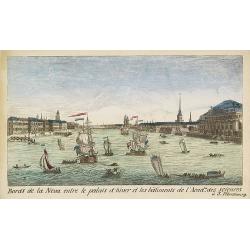
Bords de la Neva entre le palais d'hiver et les bâtiments de l'Acad.ie des Sciences à S.Pétersbourg.
Showing the Neva with the Winter Palace in St. Peterburg. J. Chereau was a publisher of optical prints, established in Paris, rue St.Jacques.In the eighteenth and ninetee...
Place & Date: Paris, ca. 1750
Selling price: $150
Sold in 2012
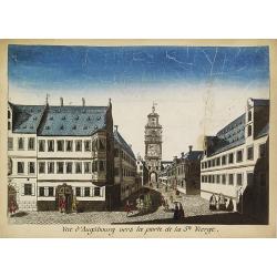
Vue d'Augsbourg vers la porte de la St. Vierge.
Showing a lively scene in 18th century Augsburg. J. Chereau was a publisher of optical prints, established in Paris, rue St.Jacques.In the eighteenth and nineteenth centu...
Place & Date: Paris, ca. 1750
Selling price: $75
Sold in 2015

Intérieur de l'Eglise St.Marc à Venise.
Showing the interior of Saint Mark's Basilica in Venice. J. Chereau was a publisher of optical prints, established in Paris, rue St.Jacques.In the eighteenth and nineteen...
Place & Date: Paris, ca. 1750
Selling price: $50
Sold in 2013
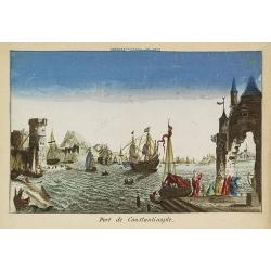
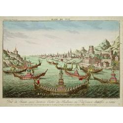
Port de Constantinople.
Showing a fanciful presentation of the harbor of Constantinople (Istanbul). J. Chereau was a publisher of optical prints, established in Paris, rue St.Jacques.In the eigh...
Place & Date: Paris, ca. 1750
Selling price: $100
Sold in 2009
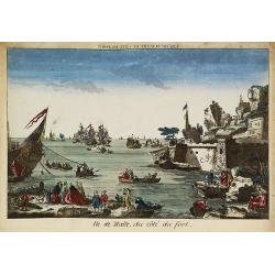
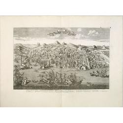
Ile de Malte, du côté du fort.
Showing to the right part of Fort St. Elmo at Valletta, with a lively foreground and a sea battle in the bay. The mirror-image title reads "Vue de Malthe du côté d...
Place & Date: Paris, ca. 1750
Selling price: $150
Sold in 2009
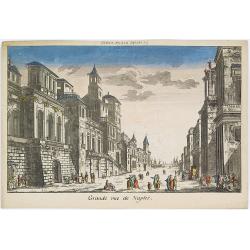
Grande rue de Naples.
Showing a street scene in Naples. J. Chereau was a publisher of optical prints, established in Paris, rue St.Jacques.In the eighteenth and nineteenth centuries there were...
Place & Date: Paris, ca. 1750
Selling price: $100
Sold in 2016
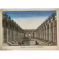
Péristijle d'un palais de S. Pétersbourg.
Showing an arcade at the Royal Palace of Saint Petersburg. J. Chereau was a publisher of optical prints, established in Paris, rue St.Jacques.In the eighteenth and ninete...
Place & Date: Paris, ca. 1750
Selling price: $150
Sold in 2018
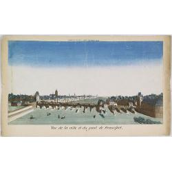
Vue de la ville et du pont de Francfort.
Showing the Medieval bridge over the river Main at Frankfurt am Main. J. Chereau was a publisher of optical prints, established in Paris, rue St.Jacques.In the eighteenth...
Place & Date: Paris, ca. 1750
Selling price: $100
Sold in 2010