Browse Listings
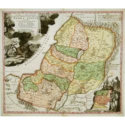
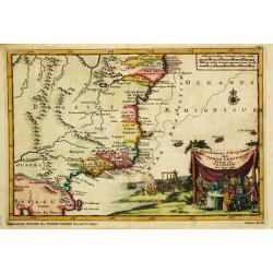
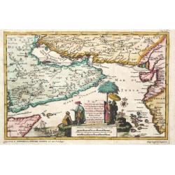
IUDAEA seu PALAESTINA... TERRA SANCTA... IUDA et ISRAEL
Map of Palestine divided among the Tribes, drawn by Homann after Guillaume Sanson. The shoreline runs from Sidon as far as Rinocorura. The Kishon River is shown as connec...
Date: Nuremberg 1707
Selling price: ????
Please login to see price!
Sold
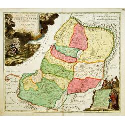
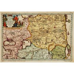
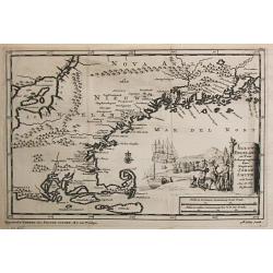
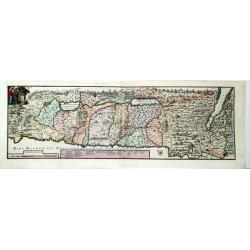
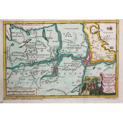
Naaukeurige kaart van Tartaryen.
A fine detailed map of Ukraine, the Crimea and the north-eastern part of the Caspian Sea. With charming pictorial title piece on the upper left-hand corner.Although not r...
Date: Leiden 1707
Selling price: ????
Please login to see price!
Sold
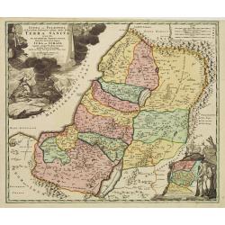
Iudæa seu Palæstina ob sacratißima Redemtoris vestigia hodie dicta Terra Sancta prout olim In Duodecim Tribus Divisa separatis ab invicem Regnis Iuda Et ...
Map of Palestine divided among the Tribes, drawn by Homann after Guillaume Sanson. The shoreline runs from Sidon as far as Rinocorura. The Kishon River is shown as connec...
Date: Nuremberg 1707
Selling price: ????
Please login to see price!
Sold in 2009
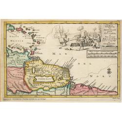
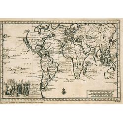
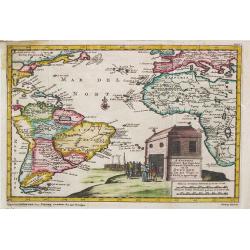
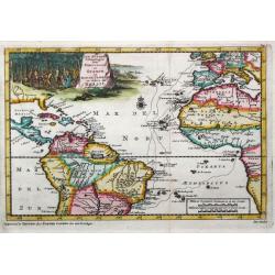
d' Engleze Volksplanting in' t Amerikaans Gewest Gujana en Rio de Las Amazones. Door de Scheeps-Togt van Charles Leig Begonnen.
Pieter van der Aa was a prolific publisher. He published a.o. ' Naaukeurige versameling der gedenkwaardigste zee- en land-reysen', a series of accounts of voyages (1706-0...
Date: Leiden, 1707
Selling price: ????
Please login to see price!
Sold
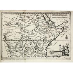
Aethiopie of Abissine. In 't gemeen 't Land van Preste Jan Genoemd.
Pieter van der Aa was a prolific publisher. He published a.o. ' Naauwkeurge versameling der gedenkwaardigste zee- en land-reysen', a series of accounts of voyages (1706-0...
Date: Leiden, 1707
Selling price: ????
Please login to see price!
Sold
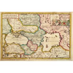
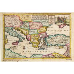
De Landschappen der Percoptize en Nogaize Tartars, Circassen, Mingrebilianen en Georgianen met die vande Crim
Pieter van der Aa was a prolific publisher. He published a.o. 'Naaukeurige versameling der gedenkwaardigste zee- en land-reysen', a series of accounts of voyages (1706-08...
Date: Leiden, 1707
Selling price: ????
Please login to see price!
Sold in 2009
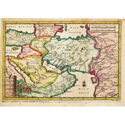
Reys-togt door Thomas Coryat van Jerusalem te Land gedaan na Asmere de Ho-Stadt des Grooten Mogols in Oostindien.
Pieter van der Aa was a prolific publisher. He published a.o. ' Naaukeurige versameling der gedenkwaardigste zee- en land-reysen', a series of accounts of voyages (1706-0...
Date: Leiden, 1707
Selling price: ????
Please login to see price!
Sold
Brasilaanze Scheepvaard door Johan Lerius Gedaan uit Vrankryk in' t Jaar 1556.
Pieter van der Aa was a prolific publisher. He published a.o. ' Naaukeurige versameling der gedenkwaardigste zee- en land-reysen', a series of accounts of voyages (1706-0...
Date: Leiden, 1707
Selling price: ????
Please login to see price!
Sold
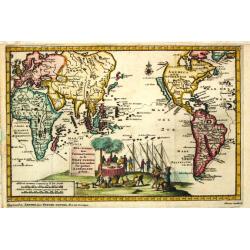
Amerika of de Nieuwe Wereld.
Pieter van der Aa was a prolific publisher. He published a.o. ' Naauwkeurge versameling der gedenkwaardigste zee- en land-reysen', a series of accounts of voyages (1706-0...
Date: Leiden, 1707
Selling price: ????
Please login to see price!
Sold
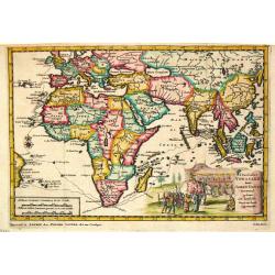
Africa.
Pieter van der Aa was a prolific publisher. He published a.o. ' Naaukeurige versameling der gedenkwaardigste zee- en land-reysen', a series of accounts of voyages (1706-0...
Date: Leiden, 1707
Selling price: ????
Please login to see price!
Sold
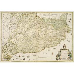
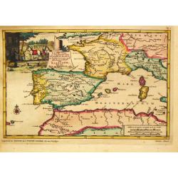
La Catalogne Dédiée au Roy..
A scarce map of Catalonia showing the coastline from Perpignan until the province of Valencia. Extensive shipping and a large title cartouche.Published by Mademoiselle Du...
Date: Paris, 1707
Selling price: ????
Please login to see price!
Sold
Nieuw Engeland in Twee Scheepstogten door Kaptein Johan Smith in de Jaren 1614 en 1615 Bestevend.
Pieter van der Aa was a prolific publisher. He published a.o. ' Naaukeurige versameling der gedenkwaardigste zee- en land-reysen', a series of accounts of voyages (1706-0...
Date: Leiden, 1707
Selling price: ????
Please login to see price!
Sold
' T noorder Deel van Amerika.
Pieter van der Aa was a prolific publisher. He published a.o. ' Naauwkeurge versameling der gedenkwaardigste zee- en land-reysen', a series of accounts of voyages (1706-0...
Date: Leiden, 1707
Selling price: ????
Please login to see price!
Sold
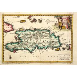
Hispaniola.
A map of the island of Hispaniola with an attractive cartouche. Pieter van der Aa was a prolific publisher. He published a.o. "Naauwkeurge versameling der gedenkwaar...
Date: Leiden, 1707
Selling price: ????
Please login to see price!
Sold in 2020
d\' Avontuurlyke Reystogt van Johan Smith uit Engeland, over zee en land, na Duitsland, Italien, en Barbarye, tot in Turkye en Tartaryen.
Pieter van der Aa was a prolific publisher. He published a.o. "Naaukeurige versameling der gedenkwaardigste zee- en land-reysen", a series of accounts of voyage...
Date: Leiden, 1707
Selling price: ????
Please login to see price!
Sold in 2017
Reys-Weg uit Brabant?Spanje en Portugal.
Pieter van der Aa was a prolific publisher. He published a.o. ' Naauwkeurge versameling der gedenkwaardigste zee- en land-reysen', a series of accounts of voyages (1706-0...
Date: Leiden, 1707
Selling price: ????
Please login to see price!
Sold in 2016
Scheep-Togt door Don Henrique de Menezes...
This is a desirable first state example of the Indian Ocean / India and Sri Lanka regions, from Van der Aa's NAAUKEURIGE VERSAMELING DER GENDENK-WAARDIGSTE ZEE EN LAND-RE...
Date: Leiden, ca. 1707
Selling price: ????
Please login to see price!
Sold in 2008
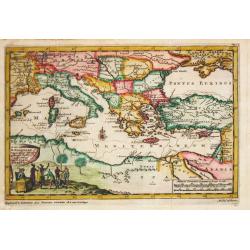
Constantinopelen en Egypten door Nicolaus Schmidt . . . Besogt.
A map of the eastern part of the Mediterranean illustrating the voyage made by Nicolaus Schmidt. Embellished with an attractive title-cartouche.Pieter van der Aa was a pr...
Date: Leiden, 1707
Selling price: ????
Please login to see price!
Sold in 2017
M. Heberers Ongelukige Voyagie gedaan in Verscheyde gedeeltens van Asia en Africa.
Pieter van der Aa was a prolific publisher. He published a.o. ' Naaukeurige versameling der gedenkwaardigste zee- en land-reysen', a series of accounts of voyages (1706-0...
Date: Leiden, 1707
Selling price: ????
Please login to see price!
Sold
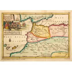
Barbaryen.
Pieter van der Aa was a prolific publisher. He published a.o. ' Naaukeurige versameling der gedenkwaardigste zee- en land-reysen', a series of accounts of voyages (1706-0...
Date: Leiden, 1707
Selling price: ????
Please login to see price!
Sold
Reys Togt Door Gil Gonzales Davila van 't Eyland St. Dominica Gedaan na de Honduras en Nicaragua.
Pieter van der Aa was a prolific publisher. He published a.o. ' Naauwkeurge versameling der gedenkwaardigste zee- en land-reysen', a series of accounts of voyages (1706-0...
Date: Leiden, 1707
Selling price: ????
Please login to see price!
Sold
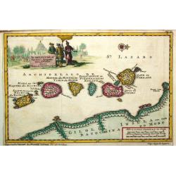
De Moluccos, of Speceri-dragende Eilanden Tussen Cilolo en Celebes gelegen.
Pieter van der Aa was a prolific publisher. He published a.o. ' Naaukeurige versameling der gedenkwaardigste zee- en land-reysen', a series of accounts of voyages (1706-0...
Date: Leiden, 1707
Selling price: ????
Please login to see price!
Sold
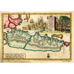
'T Koninkryk Sunda met dat van Java
Pieter van der Aa was a prolific publisher. He published a.o. ' Naaukeurige versameling der gedenkwaardigste zee- en land-reysen', a series of accounts of voyages (1706-0...
Date: Leiden, 1707
Selling price: ????
Please login to see price!
Sold
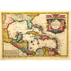
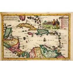
De Voor Eylanden van America.
Pieter van der Aa was a prolific publisher. He published a.o. ' Naauwkeurge versameling der gedenkwaardigste zee- en land-reysen', a series of accounts of voyages (1706-0...
Date: Leiden, 1707
Selling price: ????
Please login to see price!
Sold
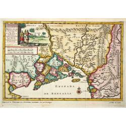
Het Koninkrijk van Bengalen en de Vloeden die zig inde Ganges ontlasten.
Pieter van der Aa was a prolific publisher. He published a.o. ' Naaukeurige versameling der gedenkwaardigste zee- en land-reysen', a series of accounts of voyages (1706-0...
Date: Leiden, 1707
Selling price: ????
Please login to see price!
Sold
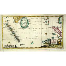
De Eilanden Maldives.
Pieter van der Aa was a prolific publisher. He published a.o. ' Naauwkeurge versameling der gedenkwaardigste zee- en land-reysen', a series of accounts of voyages (1706-0...
Date: Leiden, 1707
Selling price: ????
Please login to see price!
Sold
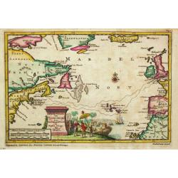
't Noorder Gedeelte van Virginie door Bartholomeus Gosnol en Martin Pringe uyt England bevaaren
Pieter van der Aa was a prolific publisher. He published a.o. ' Naaukeurige versameling der gedenkwaardigste zee- en land-reysen', a series of accounts of voyages (1706-0...
Date: Leiden, 1707
Selling price: ????
Please login to see price!
Sold in 2018
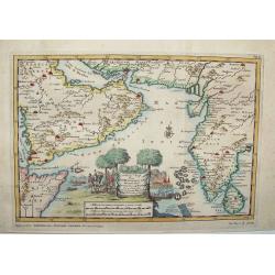
De Persiaanze Zee met d' Eylanden in deselve Tussen de Kusten van Arabier en Persie Gelegen tot aan den Indus Vloed. De Voorkusten van Guzaratte en Malabaar Tot aan Kaap Komeryn.
Pieter van der Aa was a prolific publisher. He published a.o. ' Naauwkeurge versameling der gedenkwaardigste zee- en land-reysen', a series of accounts of voyages (1706-0...
Date: Leiden, 1707
Selling price: ????
Please login to see price!
Sold in 2008
Zee en Land-Togten der Franszen Gedaan na, en in' t Americaans Gewest van Florida door Ioh. Pontius Ontdekt.
Pieter van der Aa was a prolific publisher. He published a.o. ' Naaukeurige versameling der gedenkwaardigste zee- en land-reysen', a series of accounts of voyages (1706-0...
Date: Leiden, 1707
Selling price: ????
Please login to see price!
Sold
Zee-Togten door Thomas Candys na de West Indien en van daar rondom den gantzen Arrdkloot gedaan.
Pieter van der Aa was a prolific publisher. He published a.o. '' Naaukeurige versameling der gedenkwaardigste zee- en land-reysen'', a series of accounts of voyages (1706...
Date: Leiden, 1707
Selling price: ????
Please login to see price!
Sold
d'' Oostindize Voyagien door Johan Davis tweemaal gedaan.
Pieter van der Aa was a prolific publisher. He published a.o. '' Naaukeurige versameling der gedenkwaardigste zee- en land-reysen'', a series of accounts of voyages (1706...
Date: Leiden, 1707
Selling price: ????
Please login to see price!
Sold in 2008
Zee-Togt van Alfonso d' Albuquerque na de Roode Zee, d' Arabize en Persize Kusten, met die van Ormus, Guzaratte, Goa, Malacca en Verder Indien tot aan't Eiland Java.
Pieter van der Aa was a prolific publisher. He published a.o. ' Naaukeurige versameling der gedenkwaardigste zee- en land-reysen', a series of accounts of voyages (1706-0...
Date: Leiden, 1707
Selling price: ????
Please login to see price!
Sold
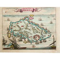
Het Eylant Rhodus.
Pieter van der Aa was a prolific publisher. He published a.o. "Naaukeurige versameling der gedenkwaardigste zee- en land-reysen", a series of accounts of voyage...
Date: Leiden, 1707
Selling price: ????
Please login to see price!
Sold in 2017
De Straat van Magellaen Sedert deszelfgs eerste ondekker, F. Magellaen Ao 1520 meermaal bevaren.
Pieter van der Aa was a prolific publisher. He published a.o. ' Naaukeurige versameling der gedenkwaardigste zee- en land-reysen', a series of accounts of voyages (1706-0...
Date: Leiden, 1707
Selling price: ????
Please login to see price!
Sold in 2008
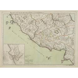
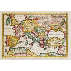
Regionum Italiae mediarum Tabula Geographica..
Fine historical map of central Italy with Tuscany and centered on Rome, in the south Pompeii, in top the island of Giglio and the town Orbetello. Lower left inset plan of...
Date: Paris, 1707
Selling price: ????
Please login to see price!
Sold in 2022
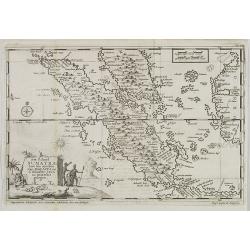
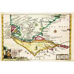
Het eiland Sumatra hoe ten aansien van Malacca . . .
Map of Sumatra, lower part of Malacca with Singapore (Singapura) and western part of Borneo. In lower left a fine title cartouche showing locals.Although not renowned for...
Date: Leiden, 1707
Selling price: ????
Please login to see price!
Sold in 2009
![[ Dedication page] From Beschryving van Spanjen en Portugaal.](/uploads/cache/23248-250x250.jpg)
[ Dedication page] From Beschryving van Spanjen en Portugaal.
With a dedication to Mr. Gerbrand Pancras Michielsz. Design by J.Goeree.Showing architectural border with allegorical figures and in top coat of arms of Spain, and Amster...
Date: Leiden, 1707
Selling price: ????
Please login to see price!
Sold in 2009
F.Draakx Ship-Vaart door de Straat en Zuyd-Zee ...
Most decorative and scarce item, showing a world map in Mercator projection. In lower part a title cartouche with Francis Drake.California, as an island, with flat northe...
Date: Leiden, 1707
Selling price: ????
Please login to see price!
Sold in 2009
Carte du Piemont et du Monferrat.
This is the top section of a separately published two sheet map of The Alps region of France and Italy. Shows the regions of Savoy in France and Piedmont in Italy, and in...
Date: Paris, 1707
Selling price: ????
Please login to see price!
Sold in 2010
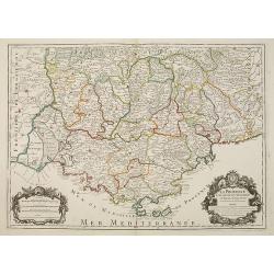
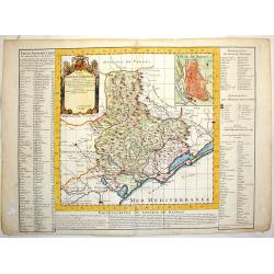
LA PROVENCE Divisée en ses Vigueries et Terres Adjacentes.
Detailed map of southern France. Showing the cities of Marseille, St.Tropez, Cannes, Nice, Antibes, Aix, Orange, Barcelonette, Senez., and Monaco, etc.Detailed map by one...
Date: Paris, 1707
Selling price: ????
Please login to see price!
Sold
A. Knivets zeldzame Reystogt door de Straat Magellaan na de Zuyd Zee tot aan zijn Vlugt in Angola achtervolgt. 3262 / H. Benzös scheeps-togt uit Italien over Spanje na de Westindize Eylanden, en Kusten van' t Zuider America. 3285
Together 2 map of the Americas. Published by Pieter van der Aa who was a prolific publisher. He published a.o. ' Naaukeurige versameling der gedenkwaardigste zee- en land...
Date: Leiden, 1707
Selling price: ????
Please login to see price!
Sold in 2021
Tabula Geographica Terrae Sanctae Auctore J. Bonfrerio Societa Jesu.
An uncommon map of Israel by the Flemish theologian Jacques Bonfrere. The map is oriented with north at top left and divided into the twelve tribes with a key at bottom. ...
Date: Amsterdam, 1707
Selling price: ????
Please login to see price!
Sold in 2021
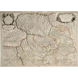
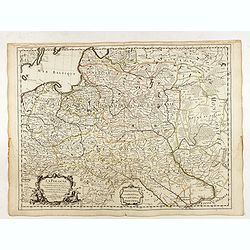
Ducatus Silesiae Glogani vera Delineatio. . .
An unusual and very attractive map of the area around Glogau (Głogów) in Poland. Highly detailed and showing many small villages, rivers, hills, and lakes. The ...
Date: Amsterdam, ca. 1707
Selling price: ????
Please login to see price!
Sold in 2020
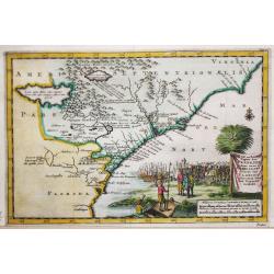
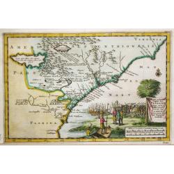
Zee en Land-Togten der Franszen Gedaan na, en in' t Americaans Gewest van Florida door Ioh. Pontius Ontdekt.
An antique map of Georgia and the North and South Carolina. Pieter van der Aa was a prolific publisher. He published a.o. 'Naaukeurige versameling der gedenkwaardigste ze...
Date: Leiden, 1707
Selling price: ????
Please login to see price!
Sold in 2021
Jan Stadens Scheepstogten. . . Riode Janeiro. . . Brasil.
A decorative map showing the Atlantic Ocean with the Caribbean and the northern part of South America. Embellished with an attractive title-cartouche, mileage scale, comp...
Date: Leiden, 1707
Selling price: ????
Please login to see price!
Sold in 2021
Land en Volk-ontdekkingen in' t Noorder gedeelte van America door P. Marquette en Joliet gedaan in' t Jaar 1673.
An important map of the Mississippi river area, illustrating the voyage of Marquette and Joliet made in 1673. Embellished with a large and decorative title-cartouche, sho...
Date: Leiden, 1707
Selling price: ????
Please login to see price!
Sold in 2021
![[Lot of 10 (2x maps / 8x views of Guyana)] d' Engleze Volksplanting in' t Amerikaans Gewest Gujana en Rio de Las Amazones. Door de Scheeps-Togt van Charles Leig Begonnen.](/uploads/cache/IMG_2322-250x250.jpg)
[Lot of 10 (2x maps / 8x views of Guyana)] d' Engleze Volksplanting in' t Amerikaans Gewest Gujana en Rio de Las Amazones. Door de Scheeps-Togt van Charles Leig Begonnen.
[Lot of 10 (2x maps / 8x views of Guyana]- d'Engelze Volkplanting in't Amerikaans gewest Gujana en Rio de las Amazones. circa 1700 - Land-Kaart van het Eiland en de Vo...
Date: Leiden, 1706-1707
Selling price: ????
Please login to see price!
Sold in 2023
Vues des villes de Londres, de Canterbury, de Colchester, et autres Lieux circonvoisins. - II. ... Vues des villes, edifices & autres choses remarquable de l'Escosse & d'Irlande. - III. and IV
Four books in one, printed Chez Pierre vander Aa, Leyden, Netherlands. Beautiful, very rare plate book of Great Britain in 6 parts with a total of 25 maps, and 216 pla...
Date: Leyden, 1707
Selling price: ????
Please login to see price!
Sold in 2023
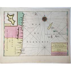
Carte Particuliere Des Costes De L'Afrique Depuis C.Del Gado Jusques Rio Mocambo.
A fine sea chart of the coasts of Mozambique and Tanzania and the Comoro Islands. Full tile: 'Carte Particuliere Des Costes De L'Afrique Depuis C.Del Gado Jusques Rio Moc...
Date: Amsterdam, 1693-1708
Selling price: ????
Please login to see price!
Sold in 2020
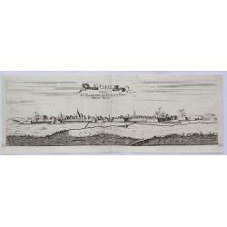
Stenay Dedic All' Illustrissimo Sig Bertuccio Valier Patritio Veneto.
A detailed copper engraved panoramic view of Stenay, a commune in the Meuse department in Grand Est in north-eastern France. The view shows the city with his buildings, c...
Date: Venice, 1708
Selling price: ????
Please login to see price!
Sold in 2021
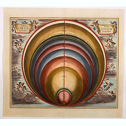
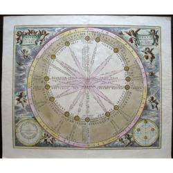
Corporum Coelestium Magnitudines.
A chart indicating distances in the heavens, using the diameter of the earth as the unit of measuring. This chart is richly adorned with elaborate cartouches and baroque ...
Date: Amsterdam, 1708
Selling price: ????
Please login to see price!
Sold in 2021
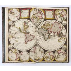
Atlas Contractus sive Mapparum Geographicarum…
Rare variant of the first edition of Peter Schenk's "Sanson's atlas", compiled shortly after he had moved to the Vijgendam in 1706, hence the date "1706&qu...
Date: Amsterdam, 1708
Selling price: ????
Please login to see price!
Sold in 2024
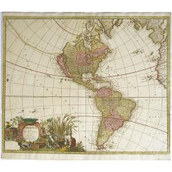
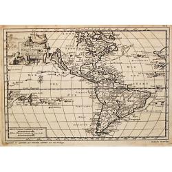
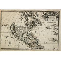
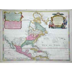
America Aurea Pars Altera Mundi
This ornamental map of the Americas depicts California as an island with a northern coastline indented by two bays on the second Sanson model. California is separated fro...
Date: Amsterdam, 1708
Selling price: ????
Please login to see price!
Sold in 2012
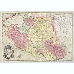
Estats de la couronne de Pologne subdivisés suivant l'estendue des palatinats. . .
Decorative and detailed map of Poland, with tip of the Black Sea lower right. Prepared by Sanson, but published by Hubert Jaillot. Engraved by Cordier. A scarce map.
Date: Amsterdam, 1708
Selling price: ????
Please login to see price!
Sold in 2012
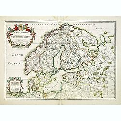
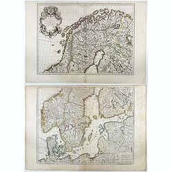
La Scandinavie et les Environs où sont les Royaumes.
Fine map of Scandinavia and the Baltic States with figurative armorial cartouche and small scale of miles. Prepared by Sanson and published by Hubert Jaillot.Engraved by ...
Date: Paris, dated 1708
Selling price: ????
Please login to see price!
Sold in 2012
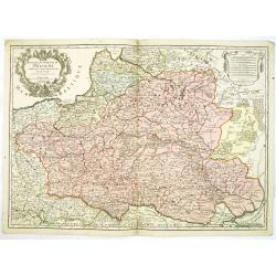
Poland Corrected from the Observations Communicated to the Royal Society at London and the Royal Academy at Paris . . .
A two sheet map of Poland, one of the largest maps of Poland ever to appear in an English Atlas. The map extends from the Baltic, Silesia and Hungary in the West to Biela...
Date: London, 1708
Selling price: ????
Please login to see price!
Sold in 2013
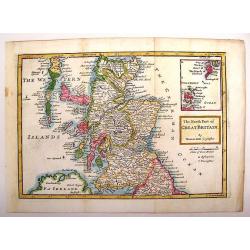
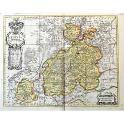
The North Part of Great Britain.
Interesting map of northern Great Britain (Scotland). It has an inlay of the Shetland and Orkney Islands. Herman Moll (1654 – 1732), was a cartographer, engraver, and ...
Date: London, 1708
Selling price: ????
Please login to see price!
Sold in 2013
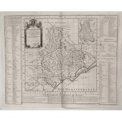
Carte du Diocese de Beziers.
An important early map of South Western France featuring the region of Languedoc that occuties a portion of the French Riviera. The top right corner features a town plan ...
Date: Amsterdam, 1708
Selling price: ????
Please login to see price!
Sold in 2015
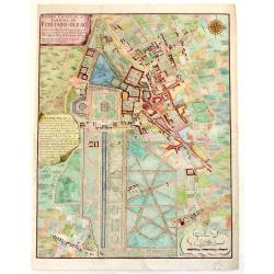
Bourg, Chateau et Jardins de Fontaine-Blaeu.
A striking plan view of Fontainebleau, a one-time Royal residence near Paris. The plan has three cartouches, and a splendid compass rose. Signed in print by C. Inselin. N...
Date: Paris, 1708
Selling price: ????
Please login to see price!
Sold in 2013
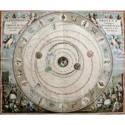
Planisphaerium Arateum Sive Compages Orbium Mundanorum ex Hypothesis, Aratea in Plano Expressa.
Beautiful celestial chart by Cellarius, published by Schenk & Valk. Based on the theories of the 3rd century Greek astronomer, Aratus, in which the Earth is at the ce...
Date: Amsterdam, 1708
Selling price: ????
Please login to see price!
Sold in 2014
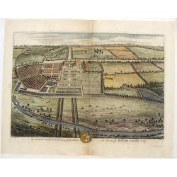
Swillington in the West Rideing of Yorkshire, the Seate of William Louther, Esq.
Fine hand-colored bird's-eye view of the great country house of Swillington. It shows the architecture, formal gardens, and the surrounding landscape. Drawn by Leonard Kn...
Date: London, 1708
Selling price: ????
Please login to see price!
Sold in 2019
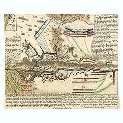
Veltslagh by Poltawa inde Ukrainie, gewonnen door den Czaar van Moskovie op den Kon. v. Sweden . . . / Pugna ad Poltawan in Ukrainia. . .
Detailed engraving of the Siege of Poltawa in Ukraine. Published in "Schouwburg van den oorlog, beginnende van koning Karel den II. tot op Koning Karel den III"...
Date: Amsterdam, after 1708
Selling price: ????
Please login to see price!
Sold in 2015
Theoria Solis per eccentricum sine epicyclo.
A fine and decorative celestial chart, from the Valk & Schenk edition of Cellarius.This chart is from the "Harmonia Macrocosmica seu Atlas Universalis et Novus&q...
Date: Amsterdam, 1708
Selling price: ????
Please login to see price!
Sold in 2020
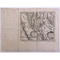
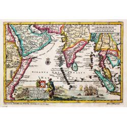
Prequ Isle de L'Inde deca Le Golfe du Gange and Prequ Isle de l
A very rare double map of India, Sri Lanka and the Maldives islands, together with a separate map of Cambodia, Thailand, Malaysia and North Sumatra.
Date: 1708
Selling price: ????
Please login to see price!
Sold in 2016
L'Amerique Septentrionale. Dressée sur les Observations de Mrs. de l'Academie Royale des Sciences...
Attractive example of De L'Isle's very important map of North America, the first map to show California as a peninsula again. Further it has a better and a more accurate ...
Date: Paris, c1708
Selling price: ????
Please login to see price!
Sold in 2016
Haemisphaerium stellatum australe antiquum.
Splendid chart showing the constellation of the southern hemisphere. Andreas Cellarius (active from 1656-1702), Dutch mathematician and geographer, rector of the Latin Sc...
Date: Amsterdam, 1708
Selling price: ????
Please login to see price!
Sold in 2018
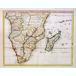
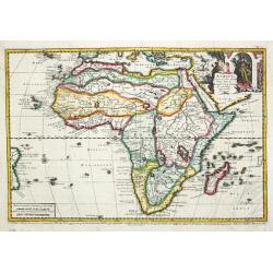
Carte du Congo et du Pays des Cafres..
Large map of the Southern part of Africa, including Madagascar An important map by one of France's most prolific map makers.The Delisle (de L'Isle) family followed the Sa...
Date: Paris, 1708
Selling price: ????
Please login to see price!
Sold in 2017
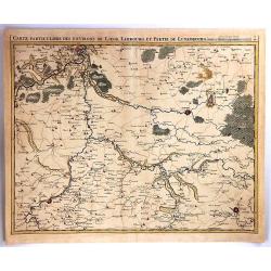
Carte Particuliere des Environs de Liege, limbourg et Partie de Luxembourg
A fine map of parts of Germany and Luxembourg by Eugene Henry Fricx in Brusselles in 1708. Published by Covens & Mortier. The map details cities, villages, forests an...
Date: BRUXELLES, 1708
Selling price: ????
Please login to see price!
Sold in 2016

Assemblée générale de la Diette de l'Empire et l'ordre de la séance de ses différents colleges.
Interesting sheet with an illustration of the progress of the Diette of the German Empire, with descriptive French text, from Chatelain's monumental 7 volume 'Atlas Histo...
Date: Amsterdam, 1708
Selling price: ????
Please login to see price!
Sold in 2017
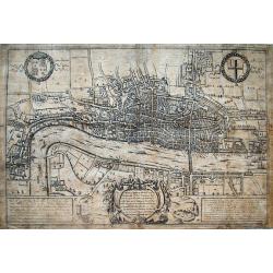
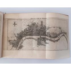
A Plan of London, Westmr. and Southwark wth ye Rivr Thames...
Hatton's famous edition of Braun & Hogenberg's view of London, first published in 1572. Shows the city in a detailed birds-eye perspective. Numerous buildings, roads,...
Date: London, 1708
Selling price: ????
Please login to see price!
Sold in 2016
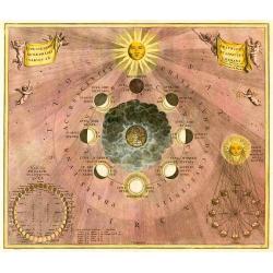
Typus Selenographicus Lunæ Phases et Aspectus Varios Adumbrans.
Celestial chart showing a selenographic diagram depicting the varying phases of the Moon. More about Celestial charts and globes [+]
Date: Amsterdam, 1708
Selling price: ????
Please login to see price!
Sold in 2016
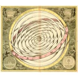
Orbium Planetarum Terram Complectentium Scenographia.
The planetary orbits encompassing the Earth. Showing the planets Mercury, Venus, Mars, Jupiter, and Saturn all orbiting the Earth. In between the Earth and Mercury is the...
Date: Amsterdam, 1708
Selling price: ????
Please login to see price!
Sold in 2016
Carte des Courones du Nord.
Denmark, Sweden, Finland and the Baltic states are included.
Date: Amsterdam, 1708
Selling price: ????
Please login to see price!
Sold in 2016
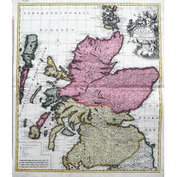
Novissima Regni Scotiae Septentrionalis et Meridionalis. . .
A rare and decorative double-page map of Scotland and its islands. Includes a wealth of place names, and extends until the Picts Wall near Carlisle. With bright original ...
Date: Amsterdam, 1708
Selling price: ????
Please login to see price!
Sold in 2018
La Pologne Dressée sur ce qu'en ot donné Starovolsk, Beauplan, Hartnoch. . .
Scarce and 2nd state of the map of Poland with the imprint "a la Courone de Diamans" : "La Pologne. Chez l’Auteur sur le Quai de l’Horloge a la C. ne d...
Date: Paris, 1707/1708
Selling price: ????
Please login to see price!
Sold in 2023
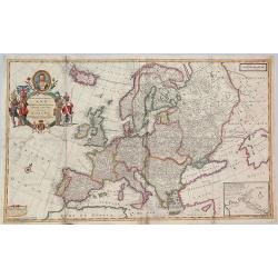
To Her Most Sacred Majesty Ann, Queen of Great Britain, France and Ireland, This Map of Europe. . .
A striking large format map of Europe, published by Herman Moll in his "New and Compleat Atlas", first published in 1708. This is from the early edition bearing...
Date: London, 1708
Selling price: ????
Please login to see price!
Sold in 2018
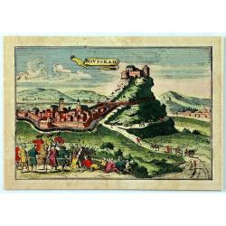
Novigrad.
An unusual panoramic view of Novigrad, Croatia. The view shows the city with his buildings, churches, town walls, Castle and surrounding landscape. In the foreground the...
Date: Paris, 1708
Selling price: ????
Please login to see price!
Sold in 2019
Carte du Diocese de Beziers ...
Beautiful copper engraved map of the diocese of Béziers, France, drawn up on the spot by Gautier, engineer and architect of the province of Languedoc, and dedicated to C...
Date: Paris, 1708
Selling price: ????
Please login to see price!
Sold in 2019
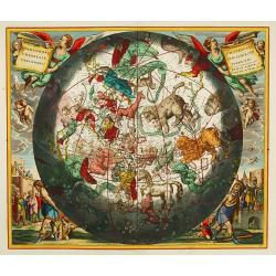
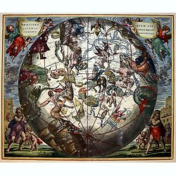
Haemisphaerium stellatum boreale cum subiecto ..
Spectacular star chart showing the constellation of the southern hemisphere superimposed upon a globe depicting America with California as an island with a rounded coastl...
Date: Amsterdam 1708
Selling price: ????
Please login to see price!
Sold