Browse Listings
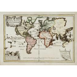
Mappe-Monde ou carte Universelle..
Uncommon world map showing California as an island. Engraved by C.Inselin.
Date: Paris 1702
Selling price: ????
Please login to see price!
Sold
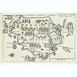
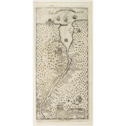
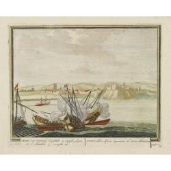
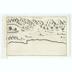
Borneo.
From a travel book deScribing the early Dutch voyages by René Augustin Constantin de Renneville Recueil des voiages qui ont servi à l'établissement & aux progrès ...
Date: Amsterdam, E. Rogers, 1702
Selling price: ????
Please login to see price!
Sold in 2012
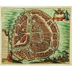
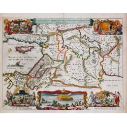
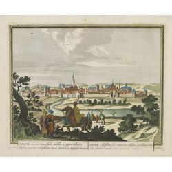
Moscou, Capitale de la Moscovie..
Detailed bird's-eye view of the town of Moscow.
Date: Leiden, 1702
Selling price: ????
Please login to see price!
Sold in 2008
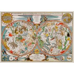
Planisphérès Celeste . Par Mr. De la Hire..
Decorative double hemisphere celestial chart, centred on the north and south poles. The constellation figures are derived from the prototypes in Bayer's Uranometria and t...
Date: Paris 1702
Selling price: ????
Please login to see price!
Sold

Cologne, ville considérable...
Handsome city plan of Cologne, situated on the River Rhine. Shows fortifications, streets, churches, etc. Decorated with a title cartouche and compass rose.
Date: Paris c.1702
Selling price: ????
Please login to see price!
Sold
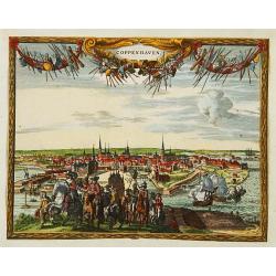
Coppenhaven.
Attractive view of the city and the port of Copenhagen. Very decorative title cartouche on the upper part.
Date: Amsterdam 1702
Selling price: ????
Please login to see price!
Sold
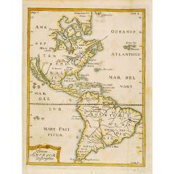
Totius Americae Descriptio.
Rare map of America with California as an island on Briggs model and lacking detail to north. From Kort Beskrifning Om Provincien Nya Swerige uti AMERICA, som nu fortjden...
Date: Stockholm 1702
Selling price: ????
Please login to see price!
Sold
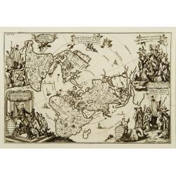
Societas Jesu..
A map from the series of maps by the Jesuit mathematician. The map is presented on a polar projection and is shaded to indicate the spread of the Catholic religion throug...
Date: Munich c.1702
Selling price: ????
Please login to see price!
Sold
America borealis 1699.
A map from the series of maps by the Jesuit mathematician. One of the two maps of North America from the series of about six of North America, produced by Scherer to show...
Date: Munich c.1702
Selling price: ????
Please login to see price!
Sold
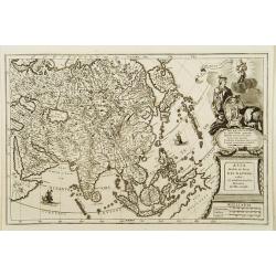
Asia Multis in locis dei matrem colit..
A map from the series of maps by the Jesuit mathematician. A general map of Asia, produced by Scherer to show the spread of Catholicism in the continent. This decorative ...
Date: Munich c.1702
Selling price: ????
Please login to see price!
Sold
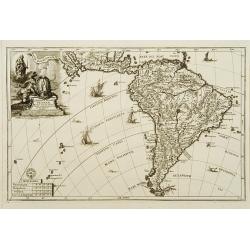
America australis dei parae Multas Sacras Aedes..
A map from the series of maps by the Jesuit mathematician. A general map of south America, produced by Scherer to show the spread of Catholicism in the continent. This de...
Date: Munich c.1702
Selling price: ????
Please login to see price!
Sold
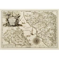
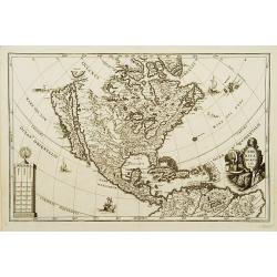
Delineatio Nova Et Vera Partis Australis Novi Mexici.
Attractive map of the Southern Portion of Baja California and contiguous Mexico, based in part on Scherer's correspondence with Fra. Eusebio Kino, the Jesuit Missionary c...
Date: Munich c.1702
Selling price: ????
Please login to see price!
Sold
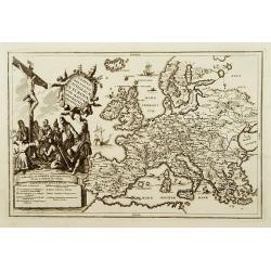
Status religionis catholicae in Europa per mappam geographicam proposito.
A map from the series of maps by the Jesuit mathematician. A general map of Europe, produced by Scherer to show the spread of Catholicism in the continent. There are 2 sh...
Date: Munich c.1702
Selling price: ????
Please login to see price!
Sold
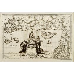
Terra Sancta Christi et Deiparae patria ..
A map from the series of maps by the Jesuit mathematician. A general map of eastern part of Medeteranean with Holy Land and Cyprus, produced by Scherer to show the spread...
Date: Munich c.1702
Selling price: ????
Please login to see price!
Sold
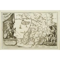
Patriarchatus Ierosolymitanus comprehendebat tres provincias..
A map from the series of maps by the Jesuit mathematician. A general map of the Holy Land and Cyprus (only listing town of Constantia, produced by Scherer to show the spr...
Date: Munich c.1702
Selling price: ????
Please login to see price!
Sold
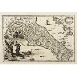
Dominium temporale pontificis Romani in Italia.
A map from the series of maps by the Jesuit mathematician. A general map of central Italy, produced by Scherer to show the spread of Catholicism in the country. Heinrich ...
Date: Munich c.1702
Selling price: ????
Please login to see price!
Sold
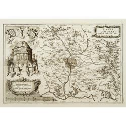
Latii Moderni geographica descriptio.
A map from the series of maps by the Jesuit mathematician. A detailed map centered on Rome, produced by Scherer to show the spread of Catholicism in the country. Heinrich...
Date: Munich c.1702
Selling price: ????
Please login to see price!
Sold
Imago b.v. Poetschensis ter Lachrimari visa toti nunc Hungariae propitia.
A map from the series of maps by the Jesuit mathematician. A general map of Hungary, produced by Scherer to show the spread of Catholicism in the country. Heinrich Schere...
Date: Munich c.1702
Selling price: ????
Please login to see price!
Sold
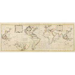
Carte Generale des toutes les Costes du Monde avec un Indice des Variations Magnetiques selon les Observations Faites en l\'Année 1700.
Large-scale world map by the well-known English scientist Edmund Halley, after whom the famous comet was named. But of greater importance were his studies on terrestrial ...
Date: Amsterdam ca. 1702
Selling price: ????
Please login to see price!
Sold
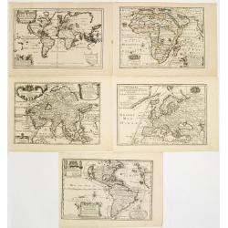
Set of world and 4 continents.
Uncommon set of world and continents. The maps of the World and North America showing California as an island. Engraved by C.Inselin.
Date: Paris 1702
Selling price: ????
Please login to see price!
Sold
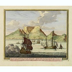
Kabo de Bona Esperança.
Attractive view of the Good Hope Cape. A fleet of Dutch vessels is present on the foreground.
Date: Amsterdam, 1702
Selling price: ????
Please login to see price!
Sold in 2008
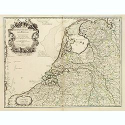
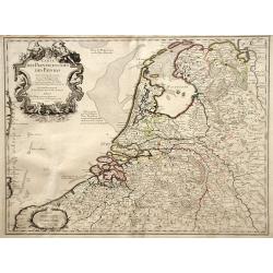
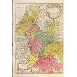
Carte des Provinces Unies des Pays Bas.
Rare first edition "Chez l'Auteur Rue des Canettes préz de St. Sulpice". "The "Rue des Canettes" address appears on the original versions of map...
Date: Paris, 1702
Selling price: ????
Please login to see price!
Sold in 2020
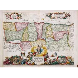
De Gelegentheyt van t' Paradys en t' Landt Canaan, mitsgaders d' eerst bewoonde Landen der Patriarchen.
Dutch so-called ' Staten' bibles, published between 1637 and c. 1760, contained five maps: The World, ' Paradise', The Perigrinations, The Promised Land Canaan, The Trave...
Date: Amsterdam, H.,J.,P. Keur, M. Doornick en P. Rotterdam, 1702
Selling price: ????
Please login to see price!
Sold
Nova Svecia hodie dicta Pensylvania.
Very rare map shows the location of Swedish settlements on the Delaware River.Prepared by Peter Lindström in 1655, who made a map titled Nova Svecia, anno 1654 och 1655,...
Date: Stockholm 1702
Selling price: ????
Please login to see price!
Sold
De Beschryving van de Reysen Pauli en Van de Andere Apostelen.
Dutch so-called ' Staten' bibles, published between 1637 and c. 1760, contained five maps: The World, ' Paradise', The Perigrinations, The Promised Land Canaan, The Trave...
Date: Amsterdam, H.,J.,P. Keur, M. Doornick en P. Rotterdam, 1702
Selling price: ????
Please login to see price!
Sold
![Bandel, de Reede van de vermaerde Koopstadt Arrakan. [Chittagong]](/uploads/cache/24998-250x250.jpg)
Bandel, de Reede van de vermaerde Koopstadt Arrakan. [Chittagong]
From Schenk's Hecatompolis sive Totius Terrarum Oppida Nobiliora Centrum.. , a collection of 100 views, dedicated to the 14-year old Prussian crown prince, the later king...
Date: Amsterdam, 1702
Selling price: ????
Please login to see price!
Sold in 2011
Salee, een vermaerde Koopstadt, en roofnest, gelegen aen de Atlantische of Spaense zee.
From Schenk's Hecatompolis sive Totius Terrarum Oppida Nobiliora Centrum.. , a collection of 100 views, dedicated to the 14-year old Prussian crown prince, the later king...
Date: Amsterdam, 1702
Selling price: ????
Please login to see price!
Sold in 2009
Amara, een voorname stadt midden in opper Ethiopie, Abyssine genaamt, ..
From Schenk's Hecatompolis sive Totius Terrarum Oppida Nobiliora Centrum.. , a collection of 100 views, dedicated to the 14-year old Prussian crown prince, the later king...
Date: Amsterdam, 1702
Selling price: ????
Please login to see price!
Sold in 2016
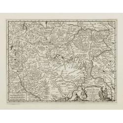
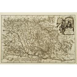
La Moscovie meridionale..
Detailed map centered on Moscow. Charming title cartouche in lower right corner.
Date: Leiden, 1702
Selling price: ????
Please login to see price!
Sold in 2008
Het Beloofde Landt Canaan door wandelt van onsen Salichmaecker Iesu Christo, neffens syne Apostelen.
Dutch so-called ' Staten' bibles, published between 1637 and c. 1760, contained five maps: The World, ' Paradise', The Perigrinations, The Promised Land Canaan, The Trave...
Date: Amsterdam, H.,J.,P. Keur, M. Doornick en P. Rotterdam, 1702
Selling price: ????
Please login to see price!
Sold in 2011
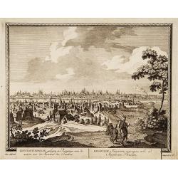
Konstantinopolien, gelegen../ Byzantium Turcarum..
From Schenk's Hecatompolis sive Totius Terrarum Oppida Nobiliora Centrum.. , a collection of 100 views, dedicated to the 14-year old Prussian crown prince, the later king...
Date: Amsterdam, 1702
Selling price: ????
Please login to see price!
Sold in 2009
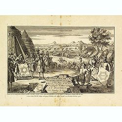
![[ Title page ] Le Theatre de la Guerre dessus et aux environs du Rhein.](/uploads/cache/27514-250x250.jpg)
[ Title page ] Le Theatre de la Guerre dessus et aux environs du Rhein.
Title page with a military scene that took place in the Rhine region during the Spanish Succession War of 1701-1714. The regions involved: Alsace, Cologne and Lorraine.Fr...
Date: Paris, 1702
Selling price: ????
Please login to see price!
Sold in 2016
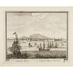
Batavia, gelegen op het eiland Java een beroemde volkplanting der Batavieren.
Town-view of Batavia (now-a-days Jakarta) seen from the harbor. On the foreground many large Dutch V.O.C. vessels.From Schenk's "Hecatompolis sive Totius Terrarum Op...
Date: Amsterdam, 1702
Selling price: ????
Please login to see price!
Sold in 2009
Carte des Provinces Unies des Pays Bas
Map of the United Provinces of the Netherlands and northern Belgium.
Date: Paris, 1702
Selling price: ????
Please login to see price!
Sold in 2010
Theatre de la Guerre dans les Pais-Bas, et Lieux circonvoisins, qui Represente les Electorates de Cologne, de Treves & de Mayence?
Detailed map showing northern French region of Champagne, Belgium and eastern Germany. Includes the cities of Frankfurt (on lower right edge), Luxembourg, Brugge, Brussel...
Date: Amsterdam, 1702
Selling price: ????
Please login to see price!
Sold in 2010
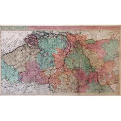
Carte des Pays Bas Catholiques. . .
Map of the Spanish, or Catholic Netherlands - a section of the Low Countries controlled by Spain from the 16th to 18th centuries. The map depicts areas from the Champagne...
Date: Paris, 1702
Selling price: ????
Please login to see price!
Sold in 2010
Le Cours De La Riviere Du Rhein depuis sa Source jusques a son Emboucheure ou sont distingues Tous Les Estats et Souverainetes
Colorful map of northeastern France and western Germany following the Rhine River from the North Sea and United Provinces (Netherlands) south, published by Pierre Mortier...
Date: Amsterdam, c. 1702
Selling price: ????
Please login to see price!
Sold in 2010
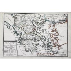
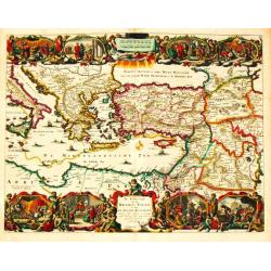
Grece Moderne ou Partie Meridionale de la Turquie en Europe. . .
Small scale, detailed map of Greece, the northern region of Crete, and the eastern coast of Asia Minor by French cartographer Nicholas de Fer.. A bordered title cartouche...
Date: Paris, 1702
Selling price: ????
Please login to see price!
Sold in 2010
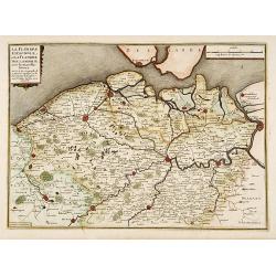
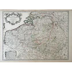
La Flandre espagnole, et la Flandre hollandoise..
Detailed map of Flanders distinguishing the part in the past under Spanish domination from that under Dutch domination. Showing Bruges, Gand, Antwerp.Engraved by F.Starck...
Date: Paris 1703
Selling price: ????
Please login to see price!
Sold
" La Terre Sainte Tirée des Memoires de M. de la. Ruë, par N.de Fer."
"Uncommon map of the Holy Land. In lower left inset map;""Tabula Mansionum ad caput 33. Numer le-passage-du-peuple Saint par les deserts de l'Arabie."...
Date: Paris 1703
Selling price: ????
Please login to see price!
Sold
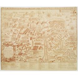
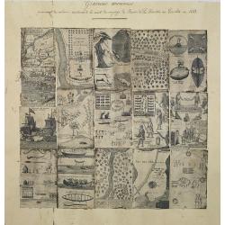
Tafel in welke vertoont werden alle Werk-tuygen behorende tot de Krygs-kunde..
An attractive instructional plate showing a collage of various systems of fortifications, both inland and coastal, and the weapons and techniques used to attack and defen...
Date: Amsterdam, 1703
Selling price: ????
Please login to see price!
Sold in 2020
Carte Generale de Toutes les Costes du Monde..
Third revised state. Mortier\'s world map of 1693 was re-engraved in 1703 by Baltasar Ruyter on a larger scale. Ruyter\'s version includes numerous changes, north-east As...
Date: Amsterdam, 1703
Selling price: ????
Please login to see price!
Sold in 2008
Title page : Le Théâtre de la Guerre dans les Pais Bas.
Decorative title page from atlas by DuVal Le Théâtre de la Guerre dans les Pais Bas..
Date: Paris, 1703
Selling price: ????
Please login to see price!
Sold
La Curlande duche et Semigalle autrsois de la Livonie
La Curlande duche et Semigalle autresois de la Livoniel / La Samogitie duche en Lituanie / Par le Sr. Sanson d?Abbeville Geogrordae de S.M. avecq Privilege Re pour vingt ...
Date: Paris, 1703
Selling price: ????
Please login to see price!
Sold in 2008
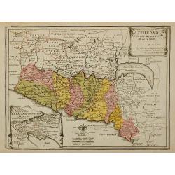
La Terre Sainte Tirée des Memoires de M. de la Ruë, ...
Uncommon map of the Holy Land. In lower left inset map Tabula Mansionum ad caput 33. Numer le-passage-du-peuple Saint par les deserts de l'Arabie. Engraved by Van Loon.Un...
Date: Paris, 1703
Selling price: ????
Please login to see price!
Sold in 2011
A compilation of 16 engravings taken from : Nouveaux Voyages de Mr. Le Baron de Lahontan, dans l'Amerique Septentrionale . . .
16 plates and maps with a title in manuscript in upper margin. The plates are quite detailed, if speculative, depicting Indians in many aspects, their clothing, accouterm...
Date: Paris, Freres l'Honore, 1703
Selling price: ????
Please login to see price!
Sold in 2012
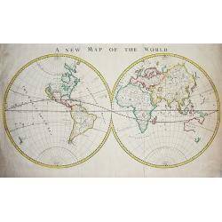
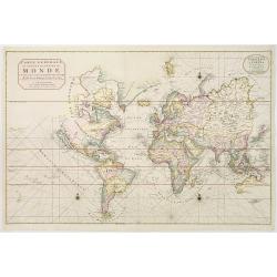
A new map of the world.
Fascinating copper-engraved double-hemisphere map published in Peter Heylin's Cosmographie 1703 edition. With several interesting features at the height of explorations ...
Date: London, 1703
Selling price: ????
Please login to see price!
Sold in 2009
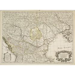
Carte de la Hongrie et des pays qui en dependoient autrefois. . .
The edition by Buache of Delisle's important map of Hungary and the Balkans. It is the first map depicting the Danube bend and the river fairly accurately. Fine decorativ...
Date: Paris, 1703
Selling price: ????
Please login to see price!
Sold in 2009
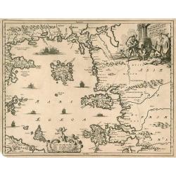
Insularum Archipelagi septentrionalis.
Aegean Islands (North)
Date: Amsterdam, 1703
Selling price: ????
Please login to see price!
Sold in 2010
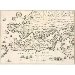
Negroponte.
Penisolur of Negroponte.
Date: Amsterdam, 1703
Selling price: ????
Please login to see price!
Sold in 2010
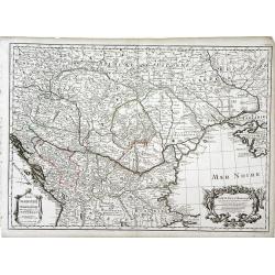
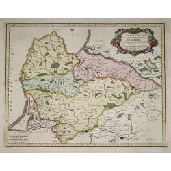
Carte de la Hongrie. . .
Finely detailed map of southeastern Europe, including the regions of Hungary, northern Greece, Bulgaria, Romania, Bohemia, Germany, Poland and the Ukraine by Guillaume de...
Date: Paris, 1703
Selling price: ????
Please login to see price!
Sold in 2010
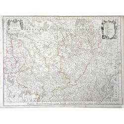
Partie Septrentionale Du Duche de Bourgogne. . .
Finely detailed map of the Duchy of Bourgogne, what is now the wine growing region of Burgundy in France by Guillaume de L'Isle. A beautifully illustrated distance key, f...
Date: Paris, 1703
Selling price: ????
Please login to see price!
Sold in 2010
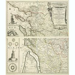
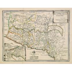
La Generalite de La Rochelle Comprenant le Pays d'Aunis, la Saintonge, &c., Divisee en Cinq Elections . . .
A stunning and strongly engraved map in two sheets and showing La Rochelle, Ile d'Orléron, Ile Ré and the entrance of the river Gironde. The map extends to include Roch...
Date: Paris, 1703
Selling price: ????
Please login to see price!
Sold in 2011

Le Nouveau Capitole ...
Nice view from Veües des plus beaux bâtimens de France, engraved by Perelle, published by Langlois.
Date: Paris, c. 1687-1703
Selling price: ????
Please login to see price!
Sold in 2011

Veüe de la Chambre des Comptes, la Ste. Chapelle et la Porte Ste. Anne.
Nice view from Veües des plus beaux bâtimens de France, engraved by Perelle, published by Langlois.
Date: Paris, c. 1687-1703
Selling price: ????
Please login to see price!
Sold in 2011

La Veüe du Monastere Royal du Val de Grace, ...
Nice view from Veües des plus beaux bâtimens de France, engraved by Perelle, published by Langlois.
Date: Paris, c. 1687-1703
Selling price: ????
Please login to see price!
Sold in 2012

La Maison de Vaux le Vicomte ...
Nice view from Veües des plus beaux bâtimens de France, engraved by Perelle, published by Langlois.
Date: Paris, c. 1687-1703
Selling price: ????
Please login to see price!
Sold in 2012
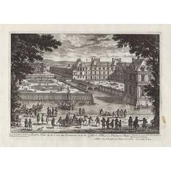
Autre Veüe de la Cour des Fontaines et de la Gallerie d'Ulisse à Fontaine-bleau.
Nice view from Veües des plus beaux bâtimens de France, engraved by Perelle, published by Langlois.
Date: Paris, c. 1687-1703
Selling price: ????
Please login to see price!
Sold in 2012
![[Nine plans on a sheet] Winochs-Bergen - Aras of Atrecht - Bethune - Grevelingen - Gent - Aath - Ostende - Yperen - Condee.](/uploads/cache/48112-250x250.jpg)
[Nine plans on a sheet] Winochs-Bergen - Aras of Atrecht - Bethune - Grevelingen - Gent - Aath - Ostende - Yperen - Condee.
An attractive plate reuniting 9 city plans of Winochs-Bergen, Aras of Atrecht, Bethune, Grevelingen, Gent, Aath, Ostende, Yperen, Condee. Printed in red. Rare.
Date: Amsterdam, 1703
Selling price: ????
Please login to see price!
Sold in 2023
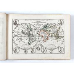
L'Atlas curieux ou le Monde réprésente dans des cartes. . .
The table is dated 1703.The atlas starts with a decorative engraved title page, followed by an engraving of globes, two celestials, two world maps , with maps of French p...
Date: Paris, 1703
Selling price: ????
Please login to see price!
Sold in 2024
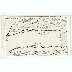
Porto il Desire.
Simplified bird's-eye view of Port Desire or Puerto Deseado in present-day Argentina.From volume two of the French reissue of the account of early Dutch voyages. The Fren...
Date: Amsterdam, E. Rogers, 1703
Selling price: ????
Please login to see price!
Sold in 2013
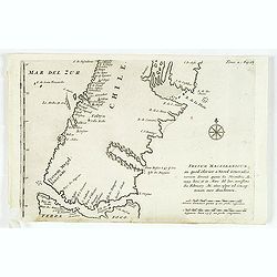
Fretum Magellanicum in quod Olivier a Noord Generalis navium. . .
Map of the southern tip of South America including parts of Chile, Argentina, and Tierra del Fuego. Cartographic elements include scales of German and Spanish miles, comp...
Date: Amsterdam, E. Roger, 1703
Selling price: ????
Please login to see price!
Sold in 2012
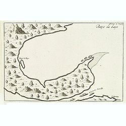
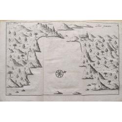
Baye la Baye.
Early map of Albay Bay on the Southeast Coast of Luzon, with the northern tip of Samar in the lower right. The mountains rising in the upper left lead to Mayon Volcano.Fr...
Date: Amsterdam, E. Rogers, 1703
Selling price: ????
Please login to see price!
Sold in 2015
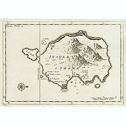
Insulae S. Thomae.
Uncommon map of the Island of St. Thomas located in the Atlantic Ocean near West Africa. From a travel book deScribing the early Dutch voyages by René Augustin Constanti...
Date: Amsterdam, E. Roger, 1703
Selling price: ????
Please login to see price!
Sold in 2012
Isle du Prince.
Simplified bird's-eye view of "Isle du Prince" in present-day Argentina.From volume two of the French reissue of the account of early Dutch voyages. The French ...
Date: Amsterdam, E. Roger, 1703
Selling price: ????
Please login to see price!
Sold in 2013
Rio Janeiro.
Simplified bird's-eye view of São Sebastião do Rio de Janeiro and Guanabara Bay, Brazil. Includes compass rose, church, and settlement.From volume two of the French rei...
Date: Amsterdam, E. Roger, 1703
Selling price: ????
Please login to see price!
Sold in 2012

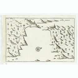
Baye de Matecalo Dans l'Isle de Ceyon / Partie du Golfe de Bengale.
Uncommon map of the Bay of Matecalo on Ceylon in the Gulf of Bengal. From the French reissue of the account of early Dutch voyages first published in 1608 by Commelin. Th...
Date: Amsterdam, E. Roger, 1703
Selling price: ????
Please login to see price!
Sold in 2016
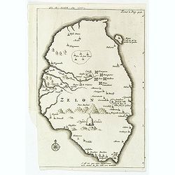
Isle de Zeilan ou Ceilon.
Uncommon map of Sri Lanka (Ceylon). From the French reissue of the account of early Dutch voyages first published in 1608 by Commelin. The French translation was carried ...
Date: Amsterdam, E. Roger, 1703
Selling price: ????
Please login to see price!
Sold in 2012
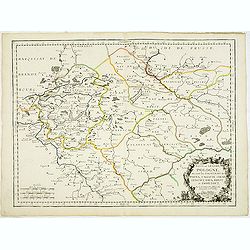
Basse ou Grande Pologne ou sont les Palatinats de Posna, Calisch, Sirad, Lencici, Rava, Brest, et Inowlocz. . .
Uncommon state of this map of Poland, covering much of present-day Poland and includes the cities of Grudziadz in the north, Warsaw in the east, Opole in the south and Gl...
Date: Paris, 1703
Selling price: ????
Please login to see price!
Sold in 2015
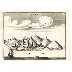
Macao.
Uncommon fanciful view of Macao, with a Dutch vessel in the foreground. From the French reissue of the account of early Dutch voyages first published in 1608 by Commelin....
Date: Amsterdam, E. Roger, 1703
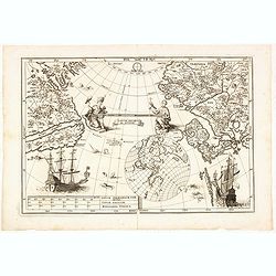
Tantum distamus ap invicem.
A map from the series of maps by the Jesuit mathematician. The map is centered on the Pacific Ocean between Asia and North America. It is an illustration of an uncommon p...
Date: Munich, 1703
Selling price: ????
Please login to see price!
Sold in 2014
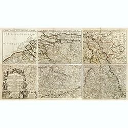
Carte pour la guerre dans les Pays-Bas Dedié et Presenté à monseigneur le Duc de Bourgogne. . . (Six sheet wall map)
Scarce six-sheet map of the southern provinces of the Low Countries and the most western provinces of Germany.Published by the heirs of Jean-Baptiste Nolin and also avail...
Date: Paris, 1703
Selling price: ????
Please login to see price!
Sold in 2015
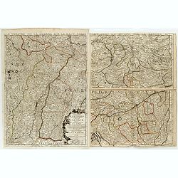
Le Theatre de la Guerre sur le Haut Rhein Contenant l'Alsace. . . (Three sheet wall map)
Scarce three-sheet map of the Alsace province in France and Germany.Published by the heirs of Jean-Baptiste Nolin and also available with the Brussels book seller Leonard...
Date: Paris, 1703
Selling price: ????
Please login to see price!
Sold in 2015
Rio Janeiro.
Scarce map of the Guanabara Bay with Rio de Janeiro, from Constantin Renneville's "Recueil des voyages qui ont servi a l'etablissement et aux progres de la Compagnie...
Date: Amsterdam, 1703
Selling price: ????
Please login to see price!
Sold in 2015
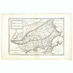
Thracia Antiqua.
This map depicts the historic and geographical region of Thrace in south eastern Europe, bordering on todays Greece, European Turkey and Bulgaria. Map shows parts of the ...
Date: Germany, 1703
Selling price: ????
Please login to see price!
Sold in 2015
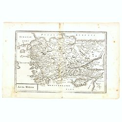
Asia Minor.
A fascinating and detailed map of Asia Minor, from an English edition of Cellarius' Geographia Antiqua. Cyprus prominent, as are many of the Greek Islands
Date: Germany, 1703
Selling price: ????
Please login to see price!
Sold in 2015
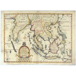
A New Map of the East Indies taken form Mr. de Fer's Map of Asia.
Striking scarce regional map of India and the East Indies, extending from Southeast Asia, the Philippines, China and Tibet in the East to India and the Maldives in the We...
Date: London, 1703
Selling price: ????
Please login to see price!
Sold in 2015
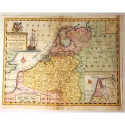
A New Map of the Netherlands or Low Countries.
Decorative map of the Netherlands, with a large sailing ship, and an inset of the Sea Coasts of Holland. Also included, is a fine coat of arms with a Unicorn and a Lion. ...
Date: London, 1703
Selling price: ????
Please login to see price!
Sold in 2015
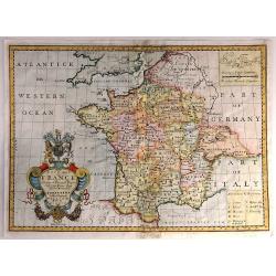
New Map of France Shewing its Principal Divisions, Chief Cities, Townes, Ports, Rivers, Mountains &c. Dedicated to His Highness William Duke of Gloucester...
A striking map of France divided by its provinces, including details such as mountains. The cartouche is splendid, and it includes the Gloucester coat of arms, fruit and ...
Date: Oxford, 1703
Selling price: ????
Please login to see price!
Sold in 2016
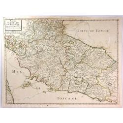
Estats de L'Eglise et de Toscane....
A fine and highly detailed map covering Tuscany, the States of the Church and neighbouring regions and the island of Elbe. This edition is dated 1703.Nicolas Sanson (1600...
Date: Paris, 1703
Selling price: ????
Please login to see price!
Sold in 2016