Browse Listings
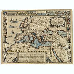
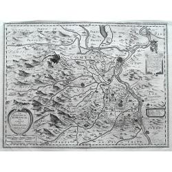
A new mappe of the Romane Empire. . .
This delightful map of the Roman Empire has six lovely bird's-eye vignette views of important cities (Rome, Genoa, Jerusalem, Venice, Constantinople & Alexandria), an...
Date: London, 1626
Selling price: ????
Please login to see price!
Sold in 2019
![Summa philosophiae quadripartita, de rebus dialecticis, moralibus et metaphysicis . . [ With unrecorded world map ]](/uploads/cache/28639-250x250.jpg)
Summa philosophiae quadripartita, de rebus dialecticis, moralibus et metaphysicis . . [ With unrecorded world map ]
On page 107 a finely copper engraved world map (88x84mm.) Paradigma Terrae Plagas 4.ac 12. Ventorum situm indicans., centered on Europe and Africa, with parts of America,...
Date: Leiden, Peter Rigaud, 1626
![A Mapp of the Sommer Islands..[Mappa Aestivarum Insularum]..](/uploads/cache/15769-250x250.jpg)
A Mapp of the Sommer Islands..[Mappa Aestivarum Insularum]..
Title in both English and Latin. English text on verso. The map was beautifully engraved by Abraham Goos in Amsterdam for Speed's Prospect Of The Most Famous Parts Of The...
Date: London 1626
Selling price: ????
Please login to see price!
Sold
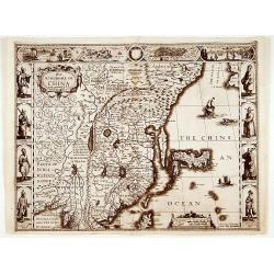
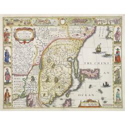
The kingdome of China..
Speed?s splendidly embellished map of China and Japan. The upper borders illustrate the cities of Macao and Quinzay (Hangchow). Further images depict the curious Chinese ...
Date: London 1626
Selling price: ????
Please login to see price!
Sold
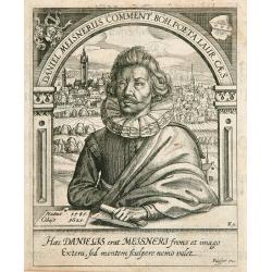
Daniel Meisnerus Comment..
Very skilfully engraved portrait of Daniel Meisner from a rare work printed by Eberhard Kieser: Thesaurus Philo-Politicus. Das ist Politisches Schatzkästlein guter Herre...
Date: Frankfurt, 1626
Selling price: ????
Please login to see price!
Sold
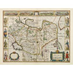
A newe map of Tartary.
One of the most decorative maps of Tartary, known for its figured borders with people in local dress, among them a woman and man in local dress. Upper panel of town panor...
Date: London 1626
Selling price: ????
Please login to see price!
Sold
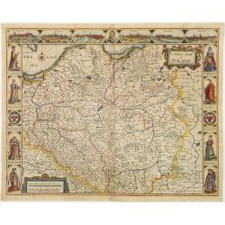
A Newe mape of Poland ...
From Speed's Prospect of the most famous parts of the world . A decorative carte à figures , with side panels depicting costumes of a Polonian Gentleman and Gentlewoman ...
Date: London 1626
Selling price: ????
Please login to see price!
Sold
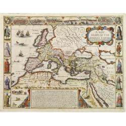
A new mappe of the Romane Empire newly described by I:Speede..
The map has six bird's-eye views of cities (Rome, Genoa, Jerusalem, Venice, Constantinople & Alexandria), and ten costume vignettes. In the sea off Ireland is a sea-b...
Date: London 1626
Selling price: ????
Please login to see price!
Sold
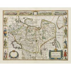
A newe map of Tartary.
One of the most decorative maps of Tartary, known for its figured borders with people in local dress, among them a woman and man in local dress. Upper panel of town panor...
Date: London 1626
Selling price: ????
Please login to see price!
Sold
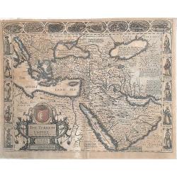
The Turkish Empire. Newly Augmented by John speed. 1626
Nice example of the Speed map of the Turkish Empire.One of the most decorative maps of the region appeared in the 17th Century and the first map of the region published i...
Date: London, 1626
Selling price: ????
Please login to see price!
Sold in 2013
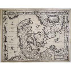
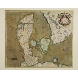
The Kingdome of Denmarke.
This map depicts Denmark, reaching as far south as Hamburg which, along with Schleswig-Holstein and parts of Sweden, was under Danish sovereignty at the time. Hamburg is ...
Date: London, 1626
Selling price: ????
Please login to see price!
Sold in 2008
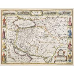
The Kingdom of Persia with the cheef Citties and Habites described by John Speede.
A stunning "carte à figures" map of the old Kingdom of Persia, including Iran, Iraq, Pakistan, known for its figured borders with people in local dress, among ...
Date: London, G.Humble, 1626
Selling price: ????
Please login to see price!
Sold
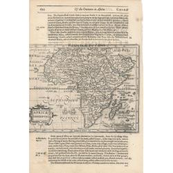
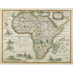
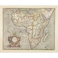
AFRICAE DESCRIPTION.
This is the English re-issue of Jodocus Hondius' map of Africa.The year after publishing a folio edition of Mercator's atlas in 1606, Hondius prepared and published a set...
Date: Amsterdam & London, (1607) 1626
Selling price: ????
Please login to see price!
Sold in 2011

Germaniae nova et accurata delineatio.
This scarce edition with no text verso is signed and dated 1626. This fine engraving shows Germany extending from the Low Countries to Poland and south as far as Switzerl...
Date: Amsterdam, 1626
Selling price: ????
Please login to see price!
Sold in 2013
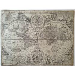
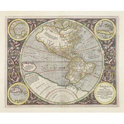
A New and Accurat map of the World...
First state, with 1626 in title and imprint "To be sold in pops-head alle by Geor Humble." A landmark map, the first atlas map to depict California as an island...
Date: London, 1626
Selling price: ????
Please login to see price!
Sold in 2011
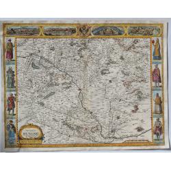
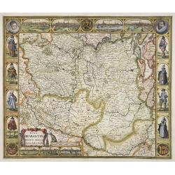
The Mape of Hungari. . .
A detailed and decorative map of Hungary, showing 2 sets of 4 costumed figures on each side of the map and views of Presburg, Ofen (Buda), Comorra and Raab. John Speed pr...
Date: London, 1626
Selling price: ????
Please login to see price!
Sold in 2019
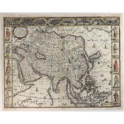
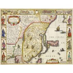
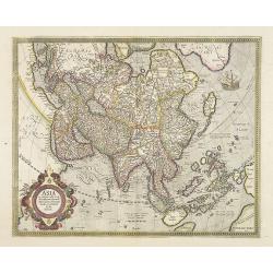
Asia with the Islands Adjoining Described. . .
John Speed's map of Asia dated 1626, decorated with 10 costumed figures and 8 town plans of important early Asian cities (Candy, Goa, Damascus, Jerusalem, Orumus, Bantam,...
Date: London, 1626
Selling price: ????
Please login to see price!
Sold in 2019
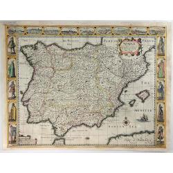
Spaine Newly Describedwith Many Indictions. . .
John Speed's map of Spain dated 1626, decorated with 10 costumed figures and 9 town plans of important early Spanish cities (Madrid, Sevilla, Livbona, Valladolid, Granada...
Date: London, 1626
Selling price: ????
Please login to see price!
Sold in 2019
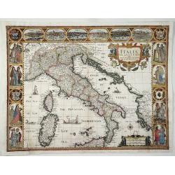
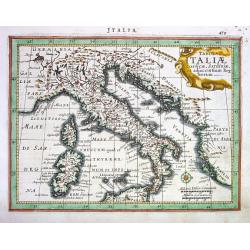
Italia Newly Augmented by J. Speede. . .
John Speed's lovely map of Italy dated 1626, decorated with 8 costumed pairs of various Italian figures, 6 town plans of early Italian cities, including (Verona, Naples, ...
Date: London, 1626
Selling price: ????
Please login to see price!
Sold in 2020
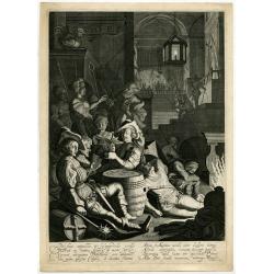
The denial of the apostle Peter.
Willem Outgerz. Akersloot (active ca. 1624-1634) worked in Haarlem. Pieter Molijn (1595-1661) was a pupil of Esaias van de Velde. He was the tutor of many dutch painters ...
Date: Haarlem, 1626
Selling price: ????
Please login to see price!
Sold in 2021
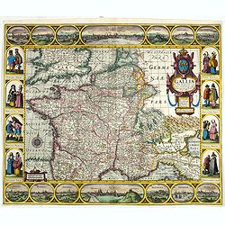
Gallia: Nova Galliae descriptio multis in locis de integro emendata simulquae effigies principum, praecipuas Gallorum urbés ac habitus exhibens, excudebat Ioannes Ianssonius Anno 1627.
Decorative map of France with a border containing 14 city views and images of regional costumes. The title cartouche includes the French coat of arms and the date of orig...
Date: Amsterdam, 1627
Selling price: ????
Please login to see price!
Sold in 2020
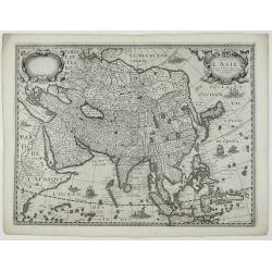
Carte De L'Asie Corrigée, et augmentée, dessus toutes les autres cy devant faictes par P. Bertius.
This rare map is according to Burden one of a set of the four known continents that Melchior Tavernier published in Paris, with Petrus Bertius' named on the map. It is ve...
Date: Paris, 1627
Selling price: ????
Please login to see price!
Sold in 2020
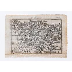
Kent.
Miniature county map of Kent. Text on verso.
Date: London, George Humble, 1627
Selling price: ????
Please login to see price!
Sold in 2020
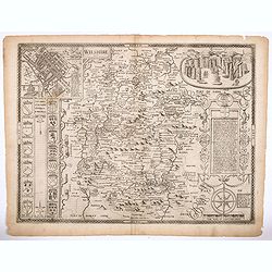
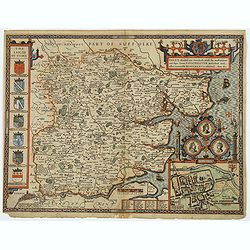
Wiltshire.
All the undoubted artistry and skill of the English cartographer John Speed. Is on display with his rendition of this English County map of Wiltshire. There are beautiful...
Date: London, 1627
Selling price: ????
Please login to see price!
Sold in 2021
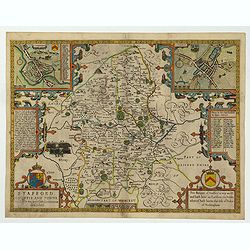
Stafford Countie and Towne with the ancient Citie Lichfield described. . .
A beautiful early edition John Speed's map of Staffordshire. As well as the county itself, the map boasts all manor of embellishments and decoration; a pair of wonderful...
Date: London, 1612 - 1627
Selling price: ????
Please login to see price!
Sold in 2022
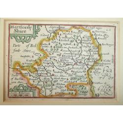
Hartforde Shire (Hertfordshire).
Fine miniature map of Hertfordshire by Pieter Van Den Keere. An attractive 17th Century map of Hertfordshire that was originally engraved between 1599 and 1605. Origina...
Date: London, George Humble, 1627
Selling price: ????
Please login to see price!
Sold in 2012
Carte de L'Afrique, corrigée et augmentée desus toutes les autres cy deuant faictes par P.Bertius.
Rare map of Africa, no date. First state, issued by Melchoir Tavernier. Most probably engraved by Cornelis Danckerts (the elder), a highly skilled engraver. Most probably...
Date: Paris, 1627
Selling price: ????
Please login to see price!
Sold in 2019
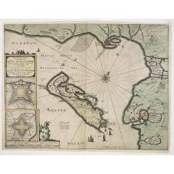
Carte particuliere des costes de Poittou, Aunis et de la Rochelle.
Finely designed map of Isle Ré and the French coast with La Rochelle.Title cartouche with title in French and Dutch. Underneath insets of fortifications of St. Martin an...
Date: Amsterdam, 1627
Selling price: ????
Please login to see price!
Sold
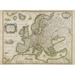
EUROP, and the cheife Cities contayned therin described. . .
A nice impression of this very decorative and prestigious "carte à figures"- map. Speed published the first world atlas in England.Many figures in national cos...
Date: London, 1627
Selling price: ????
Please login to see price!
Sold in 2013
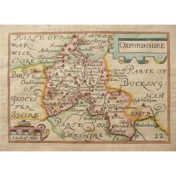
Oxfordshire.
Fine miniature map of Oxfordshire by Pieter Van Den Keere. An attractive 17th Century map of Oxfordshire that was originally engraved between 1599 and 1605. Original copp...
Date: London, George Humble, 1627
Selling price: ????
Please login to see price!
Sold in 2014
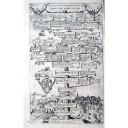
Comites Ac Duces Lucelburgici...
Rare copper engraved plate showing a genealogical tree of rulers of Luxembourg and Bohemia. With a nice and detailed view of the city of Luxembourg below. Highly decorati...
Date: Strasbourg, 1627
Selling price: ????
Please login to see price!
Sold in 2014
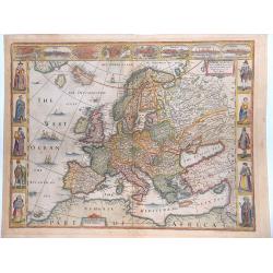
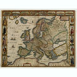
![Europ, and the Cheife Cities Contained therein Described... [Europe]](/uploads/cache/94035-250x250.jpg)
Europ, and the Cheife Cities Contained therein Described... [Europe]
A classic decorative map of Europe, published in Speed's "Prospect of the Most Famous Parts of the World", with ten costume vignettes down the sides and eight c...
Date: London c. 1627
Selling price: ????
Please login to see price!
Sold in 2016
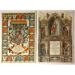
The Theatre of the Empire of Great Britaine (Title Page & Frontispiece Together)
Offered here together are the titlepage and frontispiece from John Speed's 1627 edition of “Theatre of the Empire of Great Britaine”, his monumental atlas of the Brit...
Date: London, 1627
Selling price: ????
Please login to see price!
Sold in 2015
La Principaute d'Orange et Comtat de Venaissin.
A fantastic map of the area around the cities of Avignon and Orange along the Rhone River. Highly detailed with numerous smaller villages shown, mountains, rivers, and fo...
Date: Amsterdam, 1627
Selling price: ????
Please login to see price!
Sold in 2016
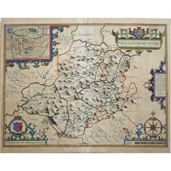
MONTGOMERY SHIRE.
An early decorative engraved 17th century map of the Welsh county of Montgomeryshire published in London and bearing the imprint of the publishers John Sudbury and George...
Date: London, 1627
Selling price: ????
Please login to see price!
Sold in 2017
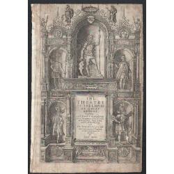
The Theatre of the Empire of Great Britaine.
The decorative title page from John Speed's Theatre of the Empire of Great Britaine Published by George Humble in 1627.
Date: London, 1627
Selling price: ????
Please login to see price!
Sold in 2018
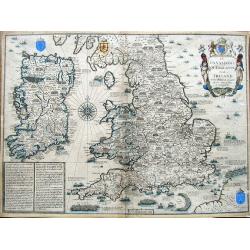
The Invasions of England and Ireland with al their Civill Wars Since the Conquest.
A fantastic map of England, Wales and Ireland that illustrates all the notable battles since the Norman Conquest (including Hastings in 1066, Bosworth Field in 1485 and F...
Date: London, ca. 1627
Selling price: ????
Please login to see price!
Sold in 2019
EVROP, and the cheife Cities contayned therin described. . . 1626.
A good impression from an early edition of this famous and decorative cartes-a-figures from the first world atlas produced by an Englishman - John Speed’s Prospect Of T...
Date: London, George Humble, 1627
Selling price: ????
Please login to see price!
Sold in 2019
Essex, divided into Hundreds, with the most ancient and fayre Towne Colchester described. . .
A highly decorative and truly stunning 17th century map of Essex by the renowned English cartographer John Speed which was published in his Theatre of the Empire of Great...
Date: London, 1627
Selling price: ????
Please login to see price!
Sold in 2020
Hispaniae nova et exacta descriptio.
Uncommon map of Spain and Portugal, engraved by David Custos.
Date: Augsburg 1627
Selling price: ????
Please login to see price!
Sold
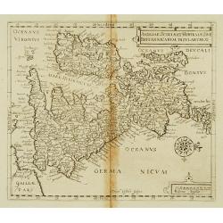
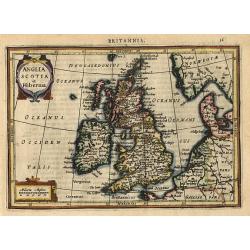
Angliae Scotiae et Hiberniae sive Britannicarum Insularum &
Uncommon map of England, Scotland and Ireland, engraved by David Custos.
Date: Augsburg 1627
Selling price: ????
Please login to see price!
Sold
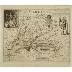
Virginia.
One of the most important printed maps of America ever produced and certainly one of the greatest influence. It became the prototype for the area for half a century. Firs...
Date: Frankfurt 1627
Selling price: ????
Please login to see price!
Sold
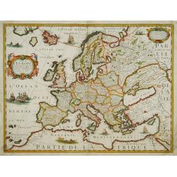
Carte de L'Europe, corrigée et augmentée desus toutes les autres cy ..
Rare map of Europe, dated 1627. First state, issued by Melchoir Tavernier. Most probably engraved by Cornelis Danckerts (the elder), a highly skilled engraver. Most proba...
Date: Paris, 1627
Selling price: ????
Please login to see price!
Sold in 2023
The Kingdome of China.
A most sought-after map of China. Decorative border vignettes including views of the cities of Quinzay and Macao along the top border with the wheeled wind machines and p...
Date: London 1627
Selling price: ????
Please login to see price!
Sold
![[Two items] Abbildung Welcher Gestalt die Spanische Silberflota von dem Hollandischen / Das Eylandt Cuba mit Deroselben Gelegenheit](/uploads/cache/23421-250x250.jpg)
[Two items] Abbildung Welcher Gestalt die Spanische Silberflota von dem Hollandischen / Das Eylandt Cuba mit Deroselben Gelegenheit
An etching showing Piet Heyn going ashore at Cuba on a sheet with letterpress. Together with a scarce engraving of the Dutch and Spanish fleets in Patanca Bay, Cuba illus...
Date: Frankfurt, 1627
Selling price: ????
Please login to see price!
Sold in 2008
The Kingdome of China.
A most sought-after map of China. Decorative border vignettes including views of the cities of Quinzay and Macao along the top border with the wheeled wind machines and p...
Date: London, 1627
Selling price: ????
Please login to see price!
Sold in 2008
Nova Brabantiae Ducatus Tabula. . .
First and only edition with borders. This beautiful and very rare carte à figures map has been engraved by Dirk Gryp who engraved only three town views in the lower left...
Date: Amsterdam, 1622-1627
Selling price: ????
Please login to see price!
Sold in 2009
Carte de L'Europe, corrigée et augmentée desus toutes les autres cy ..
Rare map of Europe, dated 1627. First state, issued by Melchoir Tavernier. Most probably engraved by Cornelis Danckerts (the elder), a highly skilled engraver. Most proba...
Date: Paris, 1627
Selling price: ????
Please login to see price!
Sold in 2019
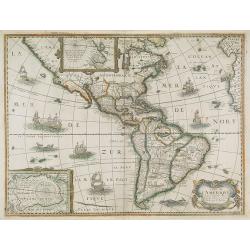
Carte de L'Amerique, corrigée et augmentée desus toutes les aultres cy deuant faictes par P.Bertius.
Rare map of America in a first state. The map itself is derived from the Jodocus Hondius map of 1618, however the southern coast of Tierra del Fuego now completed. The en...
Date: Paris, 1627
Selling price: ????
Please login to see price!
Sold in 2018

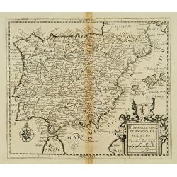
Portugalliae que olim Lusitania..
The best-known map of Portugal, after Alvares Secco (1560), orientated west to the top of the sheet. Secco's map was copied by many mapmakers and publishers for upwards o...
Date: Amsterdam, 1628
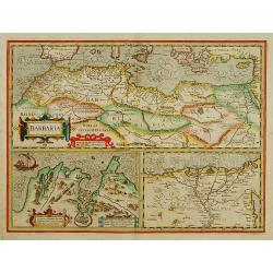
BARBARIA.
With two insets: Map of the Siege of Tunis and map of the Nile Delta.From the tenth edition of the Mercator's Atlas Sive Cosmographicae completed and reissued by Henricus...
Date: Amsterdam 1628
Selling price: ????
Please login to see price!
Sold
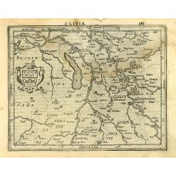
Cleve et Murs
Map of Cleve, including Eindhoven, Dusseldorf, Aachen, Maastricht, etc., published by Janssonius and included in Atlas Minor Gerardi Mercatoris. Engraved by Petrus Kaeriu...
Date: Amsterdam 1628
Selling price: ????
Please login to see price!
Sold
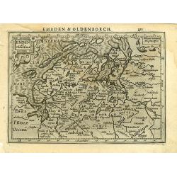
Emden et Oldenbor.
c published by Janssonius and included in Atlas Minor Gerardi Mercatoris. Engraved by Petrus Kaerius.
Date: Amsterdam 1628
Selling price: ????
Please login to see price!
Sold
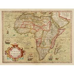
Nova Africae Tabula.
An attractive map of the continent, added by Hondius when he took over publication of Mercator\'s Atlas. Although it is based on Mercator\'s map, Hondius improved the out...
Date: Amsterdam 1628
Selling price: ????
Please login to see price!
Sold
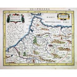
Fessae Regnum
Janssons desirable map of northern Morocco and Gibraltar, engraved for Mercators Atlas Minor. Very detailed with well engraved symbols representing towns, mountains, wood...
Date: Amsterdam 1628
Selling price: ????
Please login to see price!
Sold
Tabula Italiae Corsicae, Sardiniae,...
Beautifully engraved by Jansson Mercators Atlas Minor. Shows Italy, the Dalmatian Coast, Corsica, Sardinia and half of Sicilly with the Vulcano. Very detailed with well e...
Date: Amsterdam 1628
Selling price: ????
Please login to see price!
Sold
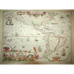
AMERICA
An stunning example of this monument to early cartography. This is one of a handful of the early foundation maps of North and South America. It has the famed inset of the...
Date: Amsterdam (1606 ) - 1628
Selling price: ????
Please login to see price!
Sold
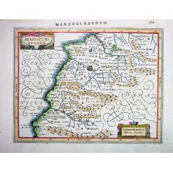
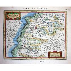
MAROCCHI REGNUM
Janssons desirable map of Morocco and the Atlas Mountains, engraved for Mercators Atlas Minor (page 579). Very detailed with well engraved symbols representing towns, mou...
Date: Amsterdam, 1628
Selling price: ????
Please login to see price!
Sold in 2008
Anglia Scotia et Hibernia.
Nice map of the British Isles and Ireland showing the major cities. Large strapwork title cartouche. Latin text on verso.
Date: Amsterdam 1628
Selling price: ????
Please login to see price!
Sold
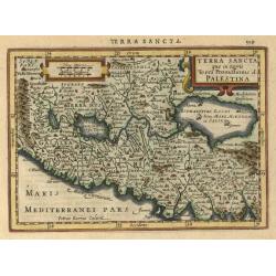
Terra Sancta..
A finely detailed copperplate engraving with north on the left. From Latin text version of Atlas Minor.
Date: Amsterdam 1628
Selling price: ????
Please login to see price!
Sold
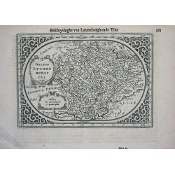
Ducatus LUTZENBURGICUS
Janssons desirable miniature-map of Luxembourg and surroundings, engraved for Mercators Atlas Minor (page 393-Ddd). Very detailed with well engraved symbols representing ...
Date: Amsterdam, c.1628
Selling price: ????
Please login to see price!
Sold
Marocchi Regnum.
Janssons beautiful map of Morocco and the Atlas Mountains, engraved for Mercators Atlas Minor (page 371-A22 2). Very detailed with a lot of topographical information and ...
Date: Amsterdam, 1628
Selling price: ????
Please login to see price!
Sold in 2008
Portugallia et Algarve
Superb map of Portugal by Jansson, engraved for Mercators Atlas Minor (page 155-V 2). The map is oriented with North to the right. Very detailed with a lot of topographic...
Date: Amsterdam, c1628
Selling price: ????
Please login to see price!
Sold
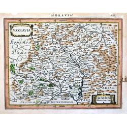
Moravia.
Janssons superb map of the eastern Czech Republic, engraved for Mercators Atlas Minor (page 459). Very detailed with a lot of topographical information with engraved symb...
Date: Amsterdam, c1628
Selling price: ????
Please login to see price!
Sold
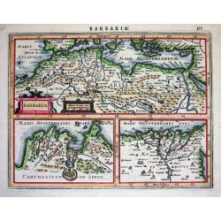
Barbaria.
Excellent map by Jansson, engraved for Mercators Atlas Minor (page 575). The map is divided in three parts: the top part is showing Northern Africa with the Mediterranean...
Date: Amsterdam, c.1628
Selling price: ????
Please login to see price!
Sold
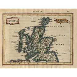
Schotia
Charming small map of Scotland decorated with a strapwork title cartouche. Latin text on verso.
Date: Amsterdam 1628
Selling price: ????
Please login to see price!
Sold
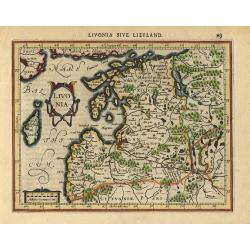
Livonia
Finely engraved small map of Estonia and Latvia filled with forests, rivers and lakes. Latin text on verso. Embellished with a strapwork title cartouche and distance scal...
Date: Amsterdam 1628
Selling price: ????
Please login to see price!
Sold
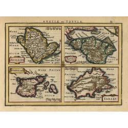
Anglesey, Wight, Garnesey, Iarsay.
This is a reduced version of Mercator's folio map with four maps on one sheet depicting the English islands of Jersey, Guernsey, Wright and Alderney. Each map is embellis...
Date: Amsterdam 1628
Selling price: ????
Please login to see price!
Sold
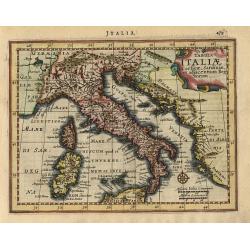
Tabula Italiae Corsicae, Sardiniae, et adjacentium Regnorum
Fine small map of all Italy, with Sardinia and Corsica, but only the northern part of Sicily. Decorated with a strapwork title cartouche and compass rose. Latin text on v...
Date: Amsterdam, 1628
Selling price: ????
Please login to see price!
Sold
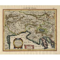
Forum Iulium Karstia, Caniola Histria etc.
Charming small map of the northern tip of the Adriatic Sea and the Gulf of Venice, present-day north-eastern Italy, Slovenia and Croatia. Two cartouches fill the Gulf of ...
Date: Amsterdam, 1628
Selling price: ????
Please login to see price!
Sold
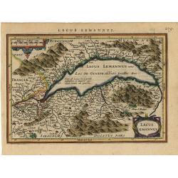
Lacus Lemannus
Handsome map of Lake Geneva with good detail of surrounding towns and villages. Decorated with 2 strapwork title cartouches. Latin text on verso.
Date: Amsterdam 1628
Selling price: ????
Please login to see price!
Sold
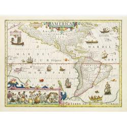
America.
Jodocus Hondius's fine delineation of the Americas is probably the most attractive map of the Western Hemisphere in the Mercator/Hondius/Janssonius succession. A clarity ...
Date: Amsterdam 1628
Selling price: ????
Please login to see price!
Sold in 2011
Daniae. . .
Map of Denmark. Ornamental title cartouche in the upper right has been painted in recent colors.Mercator was born in Rupelmonde in Flanders and studied in Louvain under G...
Date: Amsterdam, 1628
Selling price: ????
Please login to see price!
Sold in 2008
Ivtia Septentrionalis. . .
Map of southern part of Denmark. Ornamental title cartouche in the center bottom has been hand colored in recent colors.Mercator was born in Rupelmonde in Flanders and st...
Date: Amsterdam, 1628
Selling price: ????
Please login to see price!
Sold in 2016
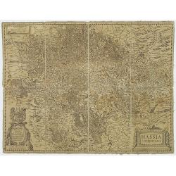
Hassa Landgraviarus.
Folding-map of Hassia: the Latin name for the German state Hessen (capital Wiesbaden). Beautiful map of a part of Germany from Jansson's edition of Mercator's Atlas.More ...
Date: Amsterdam, 1628
Selling price: ????
Please login to see price!
Sold in 2020
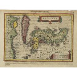
Japonia.
Drawn to a smaller scale than the 1607 map: including Korea and part of China. Engraved by Petrus Kaerius.
Date: Amsterdam, 1628
Selling price: ????
Please login to see price!
Sold in 2009
Abissinorum sive Pretiosi Ioannis Imperiu
Hondius' Prester John Map. French text on verso.
Date: Amsterdam, 1628
Selling price: ????
Please login to see price!
Sold in 2010
America sive India Nova.
The map's geography is based on the appropriate portions of Rumold Mercator's 1569 world map. The central hemisphere, which is a general map of the two continents, is sur...
Date: Amsterdam, 1628
Selling price: ????
Please login to see price!
Sold in 2009
Asia ex magna Orbis terre descriptione Gerardi Mercatoris. . .
The cartography derives directly from the 1569 Mercator world map and includes the southern landmasses of New Guinea and Terra Australis, the East Indian Islands, the Phi...
Date: Amsterdam, 1628
Selling price: ????
Please login to see price!
Sold in 2016
Africa ex magna orbis terre descriptione Gerardi Mercator. . .
Map of Africa, based on Gerard Mercator's twenty-one sheet wall map of the World, first published in 1569. Much of the interior of Africa defers to the traditions of Ptol...
Date: Amsterdam, 1628
Selling price: ????
Please login to see price!
Sold in 2010