Browse Listings
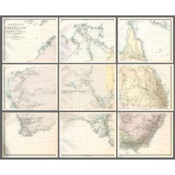
Specialkarte von Australien in 9 Blättern nach originalen & officiellen Quellen .
Large map of Australia showing towns, drainage, railways and telegraph lines and county boundaries. The map features the routes taken by explorers inland including some l...
Date: Gotha, 1875
Selling price: ????
Please login to see price!
Sold in 2010
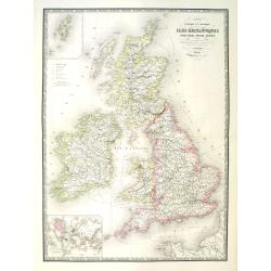
Carte physique et politique des iles britanniques.
Very large, highly detailed and uncommon map of the British Isles, with inset map of the world and the Shetland Islands. The map shows according to the title: main interr...
Date: Paris, 1875
Selling price: ????
Please login to see price!
Sold in 2010
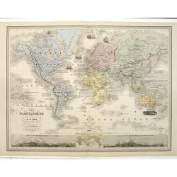
Nouveau Planisphère indiquant las grandes divisions physiques et politiques de la Terre. . .
Beautifully steel engraved map of the world on Mercator's Projection. Two large insets show the relative height of mountains in both hemispheres. A third inset shows the ...
Date: Paris / New York, 1875
Selling price: ????
Please login to see price!
Sold in 2016

Nouvelle carte de l'Amérique Méridionale et des iles qui en dépendent Dédié à l'Academie Imp.le des Sciences de l'Institut de Franc. . . . 1876
Very large, highly detailed and scarce issue of the map of South America prepared by A. Vuillemin after Adrien Hubert Brué (1786-1832). The map has shipping lines added ...
Date: Paris, 1875
Selling price: ????
Please login to see price!
Sold in 2018
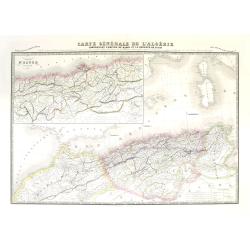
Carte générale de l'Algérie comprenant l'empire de Maroc et la régence de Tunis. Dresée d'après les derniers documents publiés par les Dépots de la Marine. . .
Very large, highly detailed and uncommon map of Algeria together with Morocco and Tunisia, with inset map "Environs d'Alger Divisés par tribus" (the surroundin...
Date: Paris, 1875
Selling price: ????
Please login to see price!
Sold
![[Tobacco Jack]](/uploads/cache/83441-250x250.jpg)
[Tobacco Jack]
An original hand colored lithograph, lower part of the print cut missing the title "Tobacco Jack" and address and date 1875.A very unusual anamorphic depiction ...
Date: New York, 1875
Selling price: ????
Please login to see price!
Sold in 2019
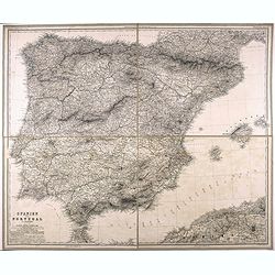
Spanien und Portugal.
Very detailed folding map of Spain and Portugal, by Vogel, C.
Date: 1875
Selling price: ????
Please login to see price!
Sold in 2021
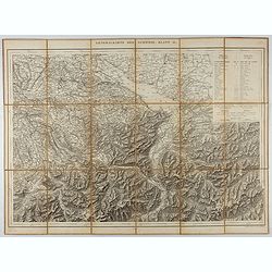
Generalkarte der Schweiz. Blatt II.
Folding map showing Lake Constance and surroundings. The map, engraved by Müllhaupt, is probably part of the 'Topographical Atlas of the Federal General Staff reduced un...
Date: Bern, 1875
Selling price: ????
Please login to see price!
Sold in 2021
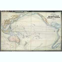
Physikalische Wandkarten. VIII. Der Grosse Ocean (Australien und Polynesien).
Giantic School wall map of Australia and the Pacific printed in chromo-lithography, in very good to mint condition and with its original card board cover. Published by &q...
Date: Berlin, D. Reimer, 1875
Selling price: ????
Please login to see price!
Sold in 2013
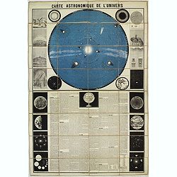
Carte Astronomique de L'Univers. . .
An educational wall map with a chart of the Solar System backed by the stars, printed in blue and black, surrounded with 17 diagrams and descriptive text in French, prepa...
Date: Paris, 1875
Selling price: ????
Please login to see price!
Sold in 2013
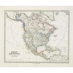
Nord-America. Entworfen u. gezeichnet von F. von Stülpnagel.
Large and detailed steel engraving showing North and Central America as well as the Caribbean.Published in Stieler's Hand Atlas.Texas named.
Date: Gotha, 1875
Selling price: ????
Please login to see price!
Sold in 2017
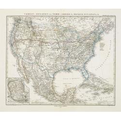
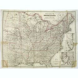
Verein-Staaten von Nord-America, Mexico, Yucatan..
Very detailed map of the United States of America showing the Caribbean. With an inset map of the surrounding area of Mexico city. Details of towns, forts, topo., railroa...
Date: Gotha, 1875
Selling price: ????
Please login to see price!
Sold in 2020
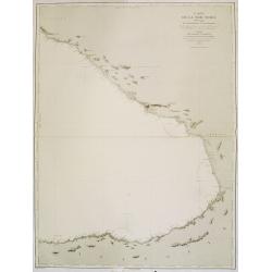
Carte de la Mer Noire. (4e Feuille). Du Cap Idokopas au Cap Zefiros.
Very detailed chart of the eastern part of the Black Sea with the coast of Georgia, including the towns of Lidzava, Anaklia, Poti, Supsa, Kobuleti. Showing soundings in m...
Date: Paris, 1860 updated to 1875
Selling price: ????
Please login to see price!
Sold in 2013
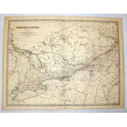
Dominion of Canada (Western Sheet).
Nice hand-colored lithographed map of the Dominion of Canada (Western Sheet). Engraved& printed by W & A.K. Johnston of Edinburgh. Published in London by William ...
Date: Edinburgh, 1875
Selling price: ????
Please login to see price!
Sold in 2014

Venice. (Lot of 3 engravings)
Three fine steel engravings featuring canal scenes in Venice, Italy. They are entitled: "VENICE", "APPROACH TO VENICE" & "THE GRAND CANAL VEN...
Date: New York, 1875
Selling price: ????
Please login to see price!
Sold in 2015

Caligula's Palace and Bridge.
Fine hand-colored steel engraving by E. Goodall from a painting by the renowned J.M.W. Turner. It was published in 1875 by Appleton in New York. The engraving features &...
Date: New York, 1875
Selling price: ????
Please login to see price!
Sold in 2015

The Lightning Express. Train express.
A very decorative print of the express train called The Lightning Express, an American railroad scene published by Currier & Ives. The train, consisting of a locomoti...
Date: New York, ca. 1875
Selling price: ????
Please login to see price!
Sold in 2014

Moonlight on the Mississippi. Vapeur du Mississippi. Clair de lune sur le Mississippi.
"Moonlight on the Mississippi" showing the Great Republic. A closeup of the famous steamboat said to be surpassed only in size, speed and luxury by the J. M. Wh...
Date: New York, ca. 1875
Selling price: ????
Please login to see price!
Sold in 2014

The Through Express. Train express.
A very decorative print of the express train called the Through Express, an American railroad scene published by Currier & Ives. A steam locomotive pulls a tender and...
Date: New York, ca. 1875
Selling price: ????
Please login to see price!
Sold in 2014
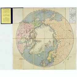
Stanford's Map of the countries round the North Pole.
A scarce example of Edward Stanford’s map depicting the entire Arctic Region. In the Russia section, the map extends until the Caspian Sea.To the left an explanation of...
Date: London, 1875
Selling price: ????
Please login to see price!
Sold in 2024

Egypt, by J. Arrowsmith.
Charming, folding map of Egypt, northern part of the Red Sea, giving a detailed overview of the Nile.In lower left a scale.Still in its original publisher's yellow advert...
Date: London, ca. 1875
Selling price: ????
Please login to see price!
Sold in 2017
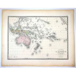
Carte Generale de L'Oceanie Cinquieme Partie du Monde ...
Pleasant engraved map that shows the entire South Pacific Ocean. It extends to include the entire East Indies, southern China, part of Japan, and across the Pacific to sh...
Date: Paris , 1875
Selling price: ????
Please login to see price!
Sold in 2020
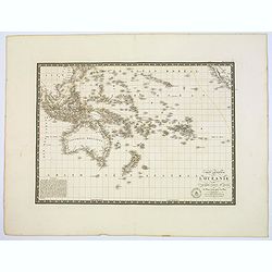
Carte Generale de l'Oceanie ou cinquieme partie du monde.
Pleasant engraved map that shows the entire South Pacific Ocean. It extends to include the entire East Indies, southern China, part of Japan, and across the Pacific to sh...
Date: Paris, 1875
Selling price: ????
Please login to see price!
Sold in 2017
Atlas Geographie Moderne Physique et Politique. . .
The 1875 edition of Brue's Atlas Geographie Moderne Physique et Politique, complete with title page, contents page and all 21 folding maps of European and regional maps o...
Date: Paris, 1875
Selling price: ????
Please login to see price!
Sold in 2018

12 engravings from The Works of Shakspere with notes By Charles Knight
The titles:"Ariel" (The Tempest) engraved by C W Sharpe after H J Townsend.“There Sleeps Titania” from The Midsummer Night’s Dream engraved by Fred Heath ...
Date: London, 1876
Selling price: ????
Please login to see price!
Sold in 2017
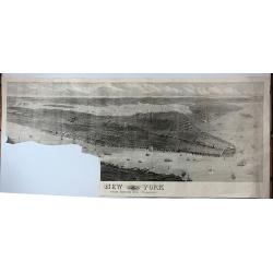
New York from Bergen Hill - Hoboken.
A large and detailed view of New York City issued in the year of America's centennial as an "extra supplement" to the Illustrated London News (Aug. 19, 1876).Fr...
Date: London, 1876
Selling price: ????
Please login to see price!
Sold in 2017
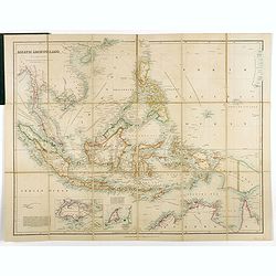
Asiatic Archipelago.
Map of the South East Asia with very good detail on Philippines. In lower left corner inset of Singapore Island. An extensive note on Singapore 'Singapore was granted to ...
Date: London, 1876
Selling price: ????
Please login to see price!
Sold in 2019
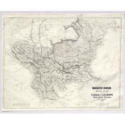
Manchester Guardian War Map of Turkey in Europe with Latest Divisions and Railways 1876.
A fine detailed War Map of Turkey in Europe with Latest Divisions and Railways 1876. It was an insert in the Manchester Gaurdian newspaper. It was published by W. & K...
Date: Edinburgh, 1876
Selling price: ????
Please login to see price!
Sold in 2019
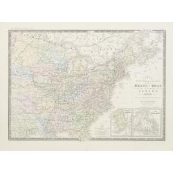
Carte de la region orientale des Éts-Unis et de la dominion du Canada.
Detailed map of The United States of America and Canada, with in lower right corner inset maps of Florida and Newfoundland.Prepared by A.Brué, re-edited by E.Levasseur a...
Date: Paris, 1876
Selling price: ????
Please login to see price!
Sold in 2020

Paris fashion plate. (238)
From Revue de la Mode. Gazette de la Famille.. Underneath the print are the names of the shops where the clothing's, perfumes, porcelains, flowers, etc., depicted in the ...
Date: Paris 1876
Selling price: ????
Please login to see price!
Sold

Paris fashion plate. (254)
From Revue de la Mode. Gazette de la Famille.. Underneath the print are the names of the shops where the clothing's, perfumes, porcelains, flowers, etc., depicted in the ...
Date: Paris 1876
Selling price: ????
Please login to see price!
Sold
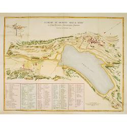
Curort St.Moritz Bad & Dorf in Ober-Engadin. . .
A detailed plan of St.Moritz, with extensive key to the principal places of interest.
Date: Zürich 1876
Selling price: ????
Please login to see price!
Sold

Paris fashion plate. (213)
From Revue de la Mode. Gazette de la Famille.. Underneath the print are the names of the shops where the clothing's, perfumes, porcelains, flowers, etc., depicted in the ...
Date: Paris, 1876
Selling price: ????
Please login to see price!
Sold in 2009

Paris fashion plate. (210)
From Revue de la Mode. Gazette de la Famille.. Underneath the print are the names of the shops where the clothing\'s, perfumes, porcelains, flowers, etc., depicted in the...
Date: Paris, 1876
Selling price: ????
Please login to see price!
Sold in 2009

Machinery Hall - International Exhibition Fairmount Park
Very fine depiction of Machinery Hal at the 1876 International World exhibition in Philadelphia. The building was 1402 feet wide and used 14 acres. The centennial exhibit...
Date: Philadelphia 1876
Selling price: ????
Please login to see price!
Sold in 2008

Argicultural Hall - International Exhibition Fairmount Park
A very fine depiction of Agricultural Hal at the 1876 International World exhibition in Philadelphia. The building was 826 feet wide and used 10.15 acres. The centennial ...
Date: Philadelphia, 1876
Selling price: ????
Please login to see price!
Sold in 2008

Main Building - International Exhibition Fairmount Park
Very fine depiction of Memorial Hal at the 1876 International World exhibition in Philadelphia. The building was 1880 feet wide and used 21.47 acres. The centennial exhib...
Date: Philadelphia 1876
Selling price: ????
Please login to see price!
Sold in 2008

Memorial Hall - International Exhibition Fairmount Park
Very fine depiction of Memorial Hal at the 1876 International World exhibition in Philadelphia. The building was 365 feet wide and used 1.5 acres. The centennial exhibiti...
Date: Philadelphia 1876
Selling price: ????
Please login to see price!
Sold in 2008

Horticultural Hall-International Exhibition Fairmount Park
Very fine depiction of Horticultural Hal at the 1876 International World exhibition in Philadelphia. The building was 360 feet wide and used 1.5 acres. The centennial exh...
Date: Philadelphia 1876
Selling price: ????
Please login to see price!
Sold in 2008
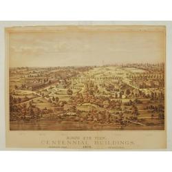
Bird's eye view, Centennial buildings.
Overview of the grounds of the 1876 International Exhibition Worldexpo in Philadelphia. The centennial exhibition took place to celibrate the 100 year eccistance of the R...
Date: Philadelphia 1876
Selling price: ????
Please login to see price!
Sold
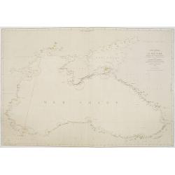
Carte générale de la Mer Noire Dressée d'après les travaux russes . . .
Chart of the Black Sea, with latitude and longitude scales, villages, banks and soundings in fathoms. Lighthouses highlighted in yellow and red.A line in red pen and ink ...
Date: Paris, 1860 with updates for 1868 - 1876
Selling price: ????
Please login to see price!
Sold in 2011
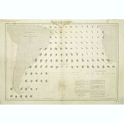
Atlantique sud carte de la direction et de l'intensité propable des vents. . . Juillet, Aout, Septembre.
Map of the south of Atlantic Ocean. Showing South America and South Africa and the different wind directions for July, August, and September prepared by L.Brault.
Date: Paris, 1876
Selling price: ????
Please login to see price!
Sold in 2011
Travelers' Rail Road Map of the United States to Accompany ‘Boston to Washington' Riverside Series Centennial Guides. . .
Lithographed folding map with excellent original outline hand color for state boundaries. 28 1/4 x 38" at neat line. Sheet size: 30 x 39 1/4". Three inset maps ...
Date: New York, G. W. & C. B. Colton & Co., 1876
Selling price: ????
Please login to see price!
Sold in 2014
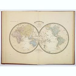
Mappemonde céleste en deux hémisphères à l'usage des écoles normales primaires.
Double hemisphere celestial wall chart, prepared by A. Logerot. Surrounded by a armilary sphere according to the Copernic system, celestial globe, solar system, movement ...
Date: Paris, c.1876
Selling price: ????
Please login to see price!
Sold in 2013
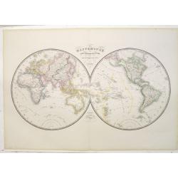
Mappemonde ou carte générale de la Terre dressée d'après les voyages les plus récents et des cartes de la Marine. . .
This double hemisphere world map was published by A. Logerot, drawn by the french map-maker A.R.Fremin (fl. c. 1810 – c. 1860), who was a French geographer active in th...
Date: Paris, 1876
Selling price: ????
Please login to see price!
Sold in 2023
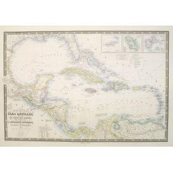
Carte générale des Iles Antilles, des iles et bancs de Bahama, des Etats-Unis . . .
Scarce and large (614 x 930 mm / 24.2 x 36.6 inches) map of the Caribbean, including the Gulf coast and central America, and insets of the Virgin Islands, Martinique and ...
Date: Paris, 1876
Selling price: ????
Please login to see price!
Sold in 2023
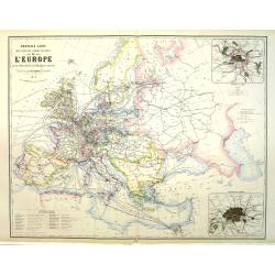
Nouvelle carte des voies de communication de l'Europe par des chemins de fer et la Navigation maritime.
Uncommon map of Europe showing the rail way system, steamboat routes connecting the European cities. Inset maps of London and Paris and a color key in lower left. Publish...
Date: Paris, 1876
Selling price: ????
Please login to see price!
Sold in 2011
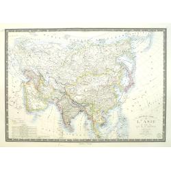
Nouvelle carte de l'Asie et des îles qui en dépendent dressée par A.Brué Géographe revue et argumentée par A. Vuillemin . . .1876
Very large, highly detailed and uncommon issue of the map of Asia prepared by A. Vuillemin after Adrien Hubert Brué (1786-1832).The map has shipping lines added and in l...
Date: Paris, 1876
Selling price: ????
Please login to see price!
Sold in 2015
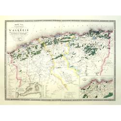
Nouvelle carte forestière de l'Algérie indiquant la division territoriale civile et militaire par provinces et départements.
Very large, highly detailed and uncommon map of Algeria, with 2 inset maps "Carte du territoire d'Alger" and "Carte du Bassin occidental de la Méditerran�...
Date: Paris, 1876
Selling price: ????
Please login to see price!
Sold
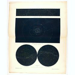
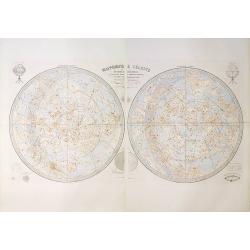
Constellations célestes des deux Hémisphères.
Celestial chart printed in 1876, published in Paris in "Atlas Universel" by Vivien de Saint Martin. Printed by Chardon aîné. Shows the northern and southern c...
Date: Paris, Chardon aîné, 1876
Selling price: ????
Please login to see price!
Sold in 2020
![LE TOUR DU MONDE EN UN CLIN DE OEIL [‘Around the World in a Wink']](/uploads/cache/85141-250x250.jpg)
LE TOUR DU MONDE EN UN CLIN DE OEIL [‘Around the World in a Wink']
Spectacular view of the World with pictorial illustration.Extra large wooden graved, highly decorative World map, with flags of major nations ,views ,costumes ,economic i...
Date: Paris, 1876
Selling price: ????
Please login to see price!
Sold in 2021

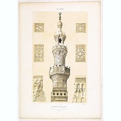
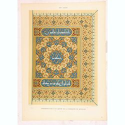
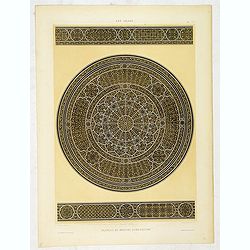
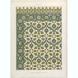
Arabesques. - Mosquée de thelay abou-rézyq détails du Mimbar. . .
Lithographed by Daumont. From the author's "L'Art Arabe d'après les monuments du Kaire…". Emile Prisse d'Avennes, Orientalist and Muslim convert, obsessive i...
Date: Paris, 1877
Selling price: ????
Please login to see price!
Sold in 2020
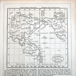
Scheidelinie für Wochen-Tag u. Datum
A rare German map of the date line in the Pacific. Shows the line running west of the Caroline Islands. Curiously the map still shows the phantom island 'Rica de Plata'! ...
Date: Regensburg, ca 1877
Selling price: ????
Please login to see price!
Sold in 2021
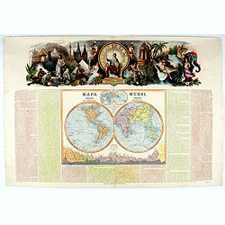
Mapa Mundi.
Very attractive large double hemisphere map with stunning panorama at top of figures representing the continents, etc. A rare and decorative map. From "Atlas geográ...
Date: Madrid, 1877
Selling price: ????
Please login to see price!
Sold in 2021
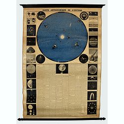
Carte Astronomique de L'Univers.
A large, decorative and informative educational chart, illustrating and describing the solar system. The top half of the chart consists of the solar system with the 12 mo...
Date: Paris ca 1877
Selling price: ????
Please login to see price!
Sold in 2022

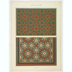
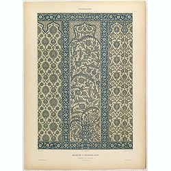
Art arabe. - Parallèle de dômes.
Lithographed by Daumont. From the author's "L'Art Arabe d'après les monuments du Kaire…". Emile Prisse d'Avennes, Orientalist and Muslim convert, obsessive i...
Date: Paris, 1877
Selling price: ????
Please login to see price!
Sold in 2023

Art arabe. - Parallèle de Minarets.
Lithographed by Daumont. From the author's "L'Art Arabe d'après les monuments du Kaire…". Emile Prisse d'Avennes, Orientalist and Muslim convert, obsessive i...
Date: Paris, 1877
Selling price: ????
Please login to see price!
Sold in 2013
Art arabe. - Mosquée de Qaytabay.
Lithographed by Daumont. From the author's "L'Art Arabe d'après les monuments du Kaire…". Emile Prisse d'Avennes, Orientalist and Muslim convert, obsessive i...
Date: Paris, 1877
Selling price: ????
Please login to see price!
Sold in 2013

Art arabe. - Scènes diverses.
Lithographed by Daumont. From the author's "L'Art Arabe d'après les monuments du Kaire…". Emile Prisse d'Avennes, Orientalist and Muslim convert, obsessive i...
Date: Paris, 1877
Selling price: ????
Please login to see price!
Sold in 2012
Art arabe. - Ornementation d'un Qorân de la mosquée de Qeyçoun.
Lithographed by Daumont. From the author's "L'Art Arabe d'après les monuments du Kaire…". Emile Prisse d'Avennes, Orientalist and Muslim convert, obsessive i...
Date: Paris, 1877
Selling price: ????
Please login to see price!
Sold in 2012
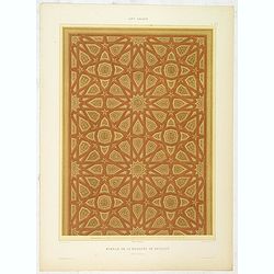
Art arabe. - Spécimens de plafonds.
Lithographed by Daumont. From the author's "L'Art Arabe d'après les monuments du Kaire…". Emile Prisse d'Avennes, Orientalist and Muslim convert, obsessive i...
Date: Paris, 1877
Selling price: ????
Please login to see price!
Sold in 2022
Art arabe. - Deux sédriehs en cuivre.
Lithographed by Daumont. From the author's "L'Art Arabe d'après les monuments du Kaire…". Emile Prisse d'Avennes, Orientalist and Muslim convert, obsessive i...
Date: Paris, 1877
Selling price: ????
Please login to see price!
Sold in 2019
Art arabe. - Mimbar de la mosquée de Qeyçoun. . .
Lithographed by Daumont. From the author's "L'Art Arabe d'après les monuments du Kaire…". Emile Prisse d'Avennes, Orientalist and Muslim convert, obsessive i...
Date: Paris, 1877
Selling price: ????
Please login to see price!
Sold in 2013
Art arabe. - Plateau en bronze damasquiné. . .
Lithographed by Daumont. From the author's "L'Art Arabe d'après les monuments du Kaire…". Emile Prisse d'Avennes, Orientalist and Muslim convert, obsessive i...
Date: Paris, 1877
Selling price: ????
Please login to see price!
Sold in 2014

Paris fashion plate. (295)
From "Revue de la Mode - Gazette de la Famille". Underneath the print are the names of the shops where the clothing's, perfumes, porcelains, flowers, etc., depi...
Date: Paris, 1877
Selling price: ????
Please login to see price!
Sold in 2015

Mosquée sépulcrale de Soultan Barqouq.
Lithograph by Philippe Benoist. Representing a religious reading, the Qoran inside Sultan Barqouq's mosque. From the author's "L'Art Arabe d'après les monuments du ...
Date: Paris, 1877
Selling price: ????
Please login to see price!
Sold in 2016

Paris fashion plate. (312)
From "Revue de la Mode - Gazette de la Famille". Underneath the print are the names of the shops where the clothing's, perfumes, porcelains, flowers, etc., depi...
Date: Paris, 1877
Selling price: ????
Please login to see price!
Sold in 2022

Paris fashion plate. (313)
From "Revue de la Mode - Gazette de la Famille". Underneath the print are the names of the shops where the clothing's, perfumes, porcelains, flowers, etc., depi...
Date: Paris, 1877
Selling price: ????
Please login to see price!
Sold in 2013
![[The City of San Francisco.]](/uploads/cache/27529-250x250.jpg)
[The City of San Francisco.]
A very decorative bird's-eye view of San Francisco. The city is seen from above the harbor, which teems with sailing and steam vessels.Published by Currier & Ives 125...
Date: New York, 1877
Selling price: ????
Please login to see price!
Sold in 2014

Art arabe. - Parallèle de Dômes.
Lithographed by Daumont. From the author's "L'Art Arabe d'après les monuments du Kaire…". Emile Prisse d'Avennes, Orientalist and Muslim convert, obsessive i...
Date: Paris, 1877
Selling price: ????
Please login to see price!
Sold in 2019
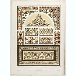
Arabesques. - Incrustations en stuc sur marbre blanc.
Lithographed by Daumont. From the author's "L'Art Arabe d'après les monuments du Kaire…". Emile Prisse d'Avennes, Orientalist and Muslim convert, obsessive i...
Date: Paris, 1877
Selling price: ????
Please login to see price!
Sold in 2015

Arabesques. - Mihrab de la mosquée de Cheykhoun. . .
Lithographed by Daumont. From the author's "L'Art Arabe d'après les monuments du Kaire…". Emile Prisse d'Avennes, Orientalist and Muslim convert, obsessive i...
Date: Paris, 1877
Selling price: ????
Please login to see price!
Sold in 2015
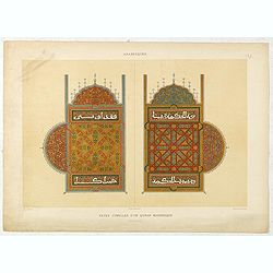
Arabesques. - Pages jumelles d'un qur'an mauresque.
Lithographed by Daumont. From the author's "L'Art Arabe d'après les monuments du Kaire…". Emile Prisse d'Avennes, an Orientalist and Muslim convert, obsessiv...
Date: Paris, 1877
Selling price: ????
Please login to see price!
Sold in 2015
Arabesques. - Etoffe conservée au musée d'Utrecht.
Lithographed by Daumont. From the author's "L'Art Arabe d'après les monuments du Kaire…". Emile Prisse d'Avennes, Orientalist and Muslim convert, obsessive i...
Date: Paris, 1877
Selling price: ????
Please login to see price!
Sold in 2023

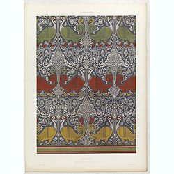
Arabesques. - Grand tapis velouté.
Lithographed by Daumont. From the author's "L'Art Arabe d'après les monuments du Kaire…". Emile Prisse d'Avennes, Orientalist and Muslim convert, obsessive i...
Date: Paris, 1877
Selling price: ????
Please login to see price!
Sold in 2015

Arabesques. - Grand tapis d'une étoffe.
Lithographed by Daumont. From the author's "L'Art Arabe d'après les monuments du Kaire…". Emile Prisse d'Avennes, Orientalist and Muslim convert, obsessive i...
Date: Paris, 1877
Selling price: ????
Please login to see price!
Sold in 2015
Arabesques. - Faïences émaillées à double jeu
Lithographed by Daumont. From the author's "L'Art Arabe d'après les monuments du Kaire…". Emile Prisse d'Avennes, Orientalist and Muslim convert, obsessive i...
Date: Paris, 1877
Selling price: ????
Please login to see price!
Sold in 2019

Arabesques. - Faïences murales du tékyeh des derwiches.
Lithographed by Daumont. From the author's "L'Art Arabe d'après les monuments du Kaire…". Emile Prisse d'Avennes, Orientalist and Muslim convert, obsessive i...
Date: Paris, 1877
Selling price: ????
Please login to see price!
Sold in 2019
Arabesques. - Mosquée d'Ibrahym Agha. Panneau en faïence.
Lithographed by Daumont. From the author's "L'Art Arabe d'après les monuments du Kaire…". Emile Prisse d'Avennes, Orientalist and Muslim convert, obsessive i...
Date: Paris, 1877
Selling price: ????
Please login to see price!
Sold in 2015

Arabesques. - Faïences murales de la Mosquée d'Ibrahym Agha.
Lithographed by Daumont. From the author's "L'Art Arabe d'après les monuments du Kaire…". Emile Prisse d'Avennes, Orientalist and Muslim convert, obsessive i...
Date: Paris, 1877
Selling price: ????
Please login to see price!
Sold in 2015