Browse Listings
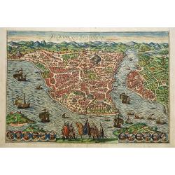
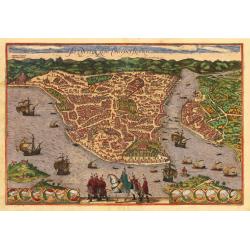
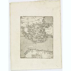
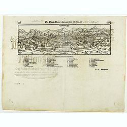
Byzantium nunc Constantinopolis.
One of the finest and most sought-after views of Istanbul. Viewed from the village of Scutari, the City is shown with all its fortifications, the original Genoese distric...
Date: Cologne, ca 1574
Selling price: ????
Please login to see price!
Sold in 2019
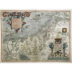
Palestinae sive totius terrae promissionis nova description (....)
A fine example of Ortelius' map of the Holy Land, published in his "Theatrum Orbis Terrarum", the first modern atlas. This famous map by Ortelius is based on th...
Date: Antwerp, ca 1574
Selling price: ????
Please login to see price!
Sold in 2021
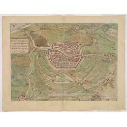
![Weimaria [on sheet with] Iena [and] Erdfordia [and] Gotha [and] Fuldensis Civitatis. [Weimar, Jena, Erfurt, Gotha, and Fulda]](/uploads/cache/84191-250x250.jpg)
Weimaria [on sheet with] Iena [and] Erdfordia [and] Gotha [and] Fuldensis Civitatis. [Weimar, Jena, Erfurt, Gotha, and Fulda]
Five bird's-eye views on one sheet: Weimar, Jena, Erfurt, Gotha and Fulda. TRANSLATION OF CARTOUCHE TEXT: Weimar, a handsome town in Thuringia, the famous seat of the Duk...
Date: Cologne, 1574
Selling price: ????
Please login to see price!
Sold in 2020
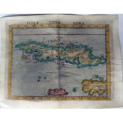
ISOLA CUBA NOVA.
One of the earliest separately published maps of Cuba. Also includes Jamaica and northwestern Hispaniola and the Cayman Islands. The map is elegantly designed and engrave...
Date: Venice, 1574
Selling price: ????
Please login to see price!
Sold in 2021
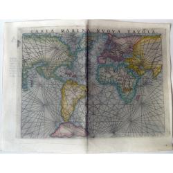
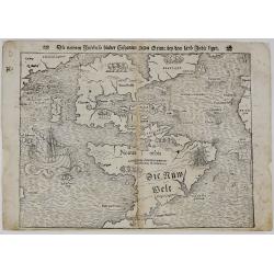
CARTA MARINA NUOVA TAVOLA.
One of the earliest published mariner’s world maps. The map is elegantly designed and engraved on copper with typical Italian taste and skill, with lots of rhumb lines....
Date: Venice, 1574
Selling price: ????
Please login to see price!
Sold in 2020
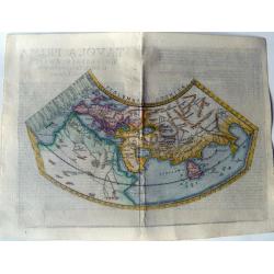
TAVOLA PRIMA UNIVERSALE ANTICA.
A unique map compared to the other Ruscelli maps corrected by Malombra. For this particular map, Malombra returned tot he original conical projection of Ptolemy. The map ...
Date: Venice, 1574
Selling price: ????
Please login to see price!
Sold in 2022
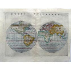
Orbis descriptio.
A separate double-hemispherical world map which was the first to appear in this format in an atlas. The map is elegantly designed and engraved on copper with typical Ital...
Date: Venice, 1574
Selling price: ????
Please login to see price!
Sold in 2021
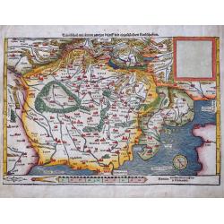
Teutschland mit seinem gantzen begriff und eingeschlossnen Landschaften
Early woodcut map from Munster's Cosmographey, one of the most influential geographical works of the 16th Century. It shows central Europe, Poland, Germany, Austria, S...
Date: Basle, c1574
Selling price: ????
Please login to see price!
Sold in 2022
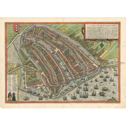
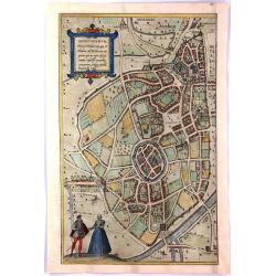
Amsterdam
This important early map of Amsterdam is from Braun and Hogenberg’s important work Civitates Orbis Terrarum, the first atlas of cities of the world.This particular map ...
Date: Cologne, 1574
Selling price: ????
Please login to see price!
Sold in 2023
Byzantium Nunc Constantinopolis
This marvelous engraving of Constantinople in original color is from an early edition of Braun & Hogenberg's Civitates Orbis Terrarum, the most prolific compilation o...
Date: Cologne, 1574
Selling price: ????
Please login to see price!
Sold in 2023
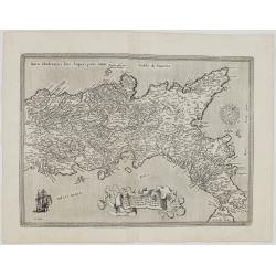
Regni Neapolitani verissima…
Very attractive antique Ortelius map of the Southern Italy. It shows the area with towns of Ascoli Piceno, Napels, Fogia, Bari, Catanzaro and Messina.The map comes from L...
Date: Antwerp, 1574
Selling price: ????
Please login to see price!
Sold in 2023
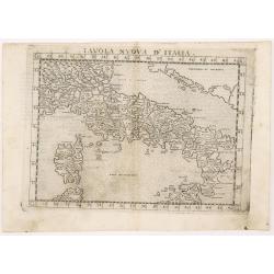
Septentrionalium Partium Nova Tabula
The map of Italy, Corsica and the Gulf of Venice.Comes from atlas “La geografia di Claudio Tolomeo Alessandrino, nuouamente tradotta di Greco in Italiano, da Girolamo R...
Date: Venice, 1574
Selling price: ????
Please login to see price!
Sold in 2023
Daniae Tabula...
Striking map of Denmark, extending from the Mechlenberg, Pomerania and Prussian Coastlines to the Norwegian Coastline, and extending north to show Stockholm. from the 157...
Date: Antwerp,1572/1574
Selling price: ????
Please login to see price!
Sold in 2012
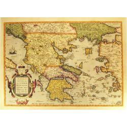
Graeciae Universae Secundum Hodiernum Neoterica Descriptio.
Published in a French edition of the 'Theatrum Orbis Terrarum'. Finely hand-colored in wash and outline. A fine map, showing Greece prominently with its neighbouring coun...
Date: Antwerp, 1572/1574
Selling price: ????
Please login to see price!
Sold in 2012
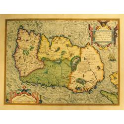
Eryn - Hiberniae, Britannicae Insulae, Nova Descriptio - Irelandt.
A beautiful map of Ireland from Ortelius' "Theatrum Orbis Terrarum." This map is significant as the first separate printed map of Ireland. It’s also one of th...
Date: Antwerp, 1574
Selling price: ????
Please login to see price!
Sold in 2012
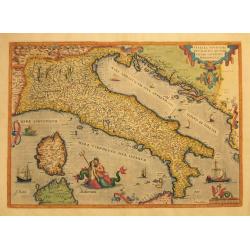
Italiae Novissima Descriptio.
Original copper engraving, published 1572/74 in a French text edition of the Atlas 'Theatrum Orbis Terrarum' at Christopher Platin in Antwerp. A highly decorative and ear...
Date: Antwerp, 1572/1574
Selling price: ????
Please login to see price!
Sold in 2012
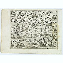
Zarra et Contado citta principale della Dalmatia posta sul mare adriatico loco Ihr.me Sri. Venetiani al pnte molestata aa Turchi.
Uncommon map of the Dalmatian coast with the town of Zadar in Croatia, with Turkish and Venetian warships in the foreground, from Giovanni Francesco Camocio's rare "...
Date: Venice, D.Bertelli, ca.1574
Selling price: ????
Please login to see price!
Sold in 2012
![[Greece]](/uploads/cache/32477-250x250.jpg)
[Greece]
Rare map of Greece. From Giovanni Francesco Camocio's rare " Isole Famose porti, fortezze, e terre maritime . . ." issued by Bertelli. The second state, which i...
Date: Venice, D.Bertelli, ca.1574
Selling price: ????
Please login to see price!
Sold in 2019
(Greece)
Uncommon map of Greece with the western part of Turkey. From Giovanni Francesco Camocio's rare " Isole Famose porti, fortezze, e terre maritime . . ." issued by...
Date: Venice, D.Bertelli, ca.1574
Selling price: ????
Please login to see price!
Sold in 2012
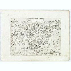
Costantinopoli città principale del gran turcho. . .
Uncommontown-plan of Constantinople. From Giovanni Francesco Camocio's rare " Isole Famose porti, fortezze, e terre maritime . . ." issued by Bertelli. The seco...
Date: Venice, D.Bertelli, ca.1574
Selling price: ????
Please login to see price!
Sold in 2015
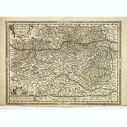
Austriae Descrip. Par Wolfganum Lazium.
Early map of the Duchy of Austria, engraved after the cartographic source by Wolfgang Lazius. This is the first state of two, before the horizontal hatching in the Neusie...
Date: Antwerp, ca. 1574
Selling price: ????
Please login to see price!
Sold in 2012
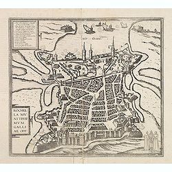
Rochella munitissimum galliae opp :
Town-plan of La Rochelle, with a numbered key (1-16) in the upper left corner gives the locations of the important buildings and landmarks.From volume II of Braun and Hog...
Date: Cologne, ca. 1574
Selling price: ????
Please login to see price!
Sold in 2012
![Russiae, Moscoviae et Tartariae Descriptio. [With Latin text on verso]](/uploads/cache/33401-250x250.jpg)
Russiae, Moscoviae et Tartariae Descriptio. [With Latin text on verso]
From a Latin text edition, v.d. Broecke estimates that 175 copies are printed. Engraved by Frans Hogenberg from an original of 1562 by Anthony Jenkinson of the English Mu...
Date: Antwerp, 1574
Selling price: ????
Please login to see price!
Sold in 2013
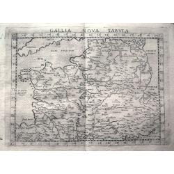
Gallia Nova Tabula.
Early map showing parts of France, Belgium, Luxembourg, Germany, Switzerland, Cornwall, and the Ligurian coast with Genoa and Milan. Engraved with mountains and rivers wi...
Date: Venice, c1574
Selling price: ????
Please login to see price!
Sold in 2013
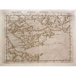
Arabia Felice Nuova Tavola.
A classical map of the Arabian Peninsular, is an enlarged version of Giacomo Gastaldi's published in 1548. Girolamo Ruscelli's edition of Ptolemy's Geographia included ne...
Date: Venice, 1574
Selling price: ????
Please login to see price!
Sold in 2014
![Russiae, Moscoviae et Tartariae Descriptio. [With Latin text on verso]](/uploads/cache/34162-250x250.jpg)
Russiae, Moscoviae et Tartariae Descriptio. [With Latin text on verso]
From a Latin text edition. Engraved by Frans Hogenberg from an original of 1562 by Anthony Jenkinson of the English Muscovy Company. The map covers the region from the Gu...
Date: Antwerp, 1574
Selling price: ????
Please login to see price!
Sold in 2014
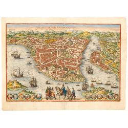
Byzantium nunc Constantinopolis.
One of the finest and most sought-after views of Istanbul. Viewed from the village of Scutari, the City is shown with all its fortifications, the original Genoese distric...
Date: Cologne, ca. 1574
Selling price: ????
Please login to see price!
Sold in 2014
Hiberniae Britannicae insulae nova descriptio.
Copied from Mercator's influential wall map of the British Isles of 1564, this is certainly the best map of Ireland of the 16th century.
Date: Antwerp, 1574
Selling price: ????
Please login to see price!
Sold in 2015
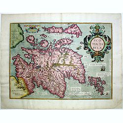
Scotiae tabula.
Very fine general map of Scotland with north to right of page. Derived from Mercator's 1564 map of the British Isles in 8 sheets.
Date: Antwerp, 1574
Selling price: ????
Please login to see price!
Sold in 2016

Americae Sive Novi Orbis, Nova Descriptio.
This is the second state of the first copperplate of Ortelius' map showing the western hemisphere, showing the prominent bulge in the South American coastline. An importa...
Date: Antwerp, 1574
Selling price: ????
Please login to see price!
Sold in 2015
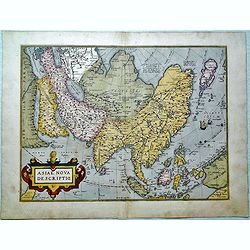
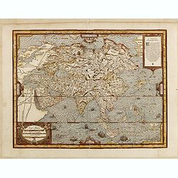
Asiae nova descriptio.
Ortelius' fine map of Asia well represents the continent at a time when Europeans were expanding their power in the Far East. The Indian subcontinent and Malaysian penins...
Date: Antwerp, 1574
Selling price: ????
Please login to see price!
Sold in 2015
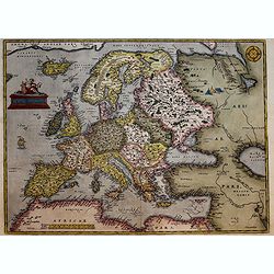
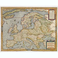
Europae.
Early edition of the classic Europa map by Ortelius. Somewhat distorted land masses: vignette of Europe being carried off by the bull (Zeus). The first plate with title A...
Date: Antwerp, 1574
Selling price: ????
Please login to see price!
Sold in 2017
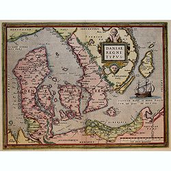
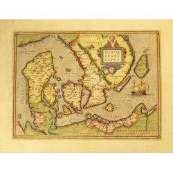
Daniae Regni Typus.
Early decorative map of Denmark, extending from the Mechlenberg, Pomerania and Prussian Coastlines to the Norwegian Coastline, and extending north to show Stockholm. Abra...
Date: Antwerp, 1574
Selling price: ????
Please login to see price!
Sold in 2017
![[Asia Minor]](/uploads/cache/35967-250x250.jpg)
[Asia Minor]
Early, attractive hand-colored woodcut map of Turkey, with an unnamed Cyprus in the lower right corner. From the German edition of Sebastian Münster's Cosmography, title...
Date: Basle, ca. 1574
Selling price: ????
Please login to see price!
Sold in 2016
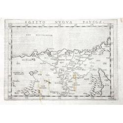
Egitto Nuova Tavola
One of the earliest obtainable maps of Egypt and the Nile delta.Extends to include Cairo, and a part of the Red Sea. Includes several pyramids. Italian text on verso.
Date: Venice, 1574
Selling price: ????
Please login to see price!
Sold in 2016
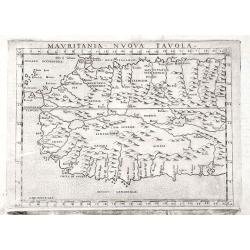
Mauritania Nuova Tavola
A very early map of Western Africa, after Ptolemy, including Gibraltar and the Canary Islands.Displays a rich system of rivers throughout, and a curious set of trees near...
Date: Venice, 1574
Selling price: ????
Please login to see price!
Sold in 2016
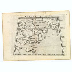
![Tabula Asiae VI. [Arabian Peninsular]](/uploads/cache/39790-250x250.jpg)
Tabula Asiae VI. [Arabian Peninsular]
The ancient depiction of Arabia, based on Claudius Ptolemy's Geographia from the second century A.D. The region appears with many interior mountains and rivers: none of w...
Date: Venice, 1574
Selling price: ????
Please login to see price!
Sold in 2017
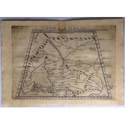
Tabula Asiae II.
A scarce map of the ancient region of Asiatic Sarmatia - now Southern Russia and part of Ukraine, around the Azov sea. Shows Armenia Maior, Iberia, Albania, Colchis, Port...
Date: Venice, 1574
Selling price: ????
Please login to see price!
Sold in 2017
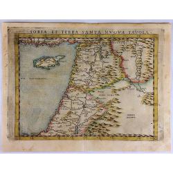
Soria et Terra Santa Nuova Tavola.
Ruscelli's map of the Holy Land, Syria and Cyprus. One of the earliest obtainable separately published maps of the region. The map first appeared in the 1561 edition of R...
Date: Venice, 1574
Selling price: ????
Please login to see price!
Sold in 2017
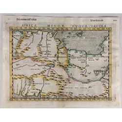
Africa Minor Nuova Tavola.
Striking impression of Ruscelli's map of the region of present day Algiers, Tunisia and Libya. Ruscelli sought the most up-to-date geographical information available, mak...
Date: Venice, 1574
Selling price: ????
Please login to see price!
Sold in 2020
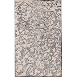
Valesia - Wallisserland.
Early woodcut map of the Valais in southern Switzerland. Showing the region at the river Rhone from the Furka Pass to St. Maurice. Published by Heinrich Petri in Basel.
Date: Basel 1574
Selling price: ????
Please login to see price!
Sold in 2017
Tabula Asiae VI. (Arabian Peninsular)
A lovely example of this classical map depicting an ancient representation of the Arabian Peninsula, based on Ptolemy's second century A.D. Geographia here called Arabia ...
Date: Venice, 1574
Selling price: ????
Please login to see price!
Sold in 2020
![Tabula Europae I [British Isles].](/uploads/cache/42111-250x250.jpg)
Tabula Europae I [British Isles].
An early double page Ptolemaic map of the British Isles from 'La Geografia Di Claudio Tolomeo Alessandrino...' published by G. Ziletti, Venice (using plates from the 1561...
Date: Venice, 1574
Selling price: ????
Please login to see price!
Sold in 2019
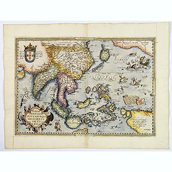
Indiae Orientalis, Insularumque Adiacientium Typus. . .
A finely hand colored example of Ortelius' highly decorative map of South East Asia, Japan, and the Philippines, etc from the Latin text edition of 1574. The map includes...
Date: Antwerp, 1574
Selling price: ????
Please login to see price!
Sold in 2018
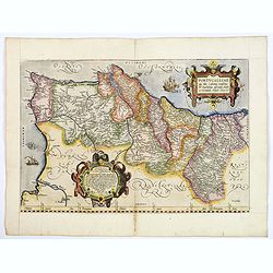
Portugalliae que olim Lusitania.
The best-known map of Portugal, after Alvares Secco (1560), map is orientated west to the top of the sheet, seen here in a fine, early impression in good color. Fernando ...
Date: Antwerp, 1574
Selling price: ????
Please login to see price!
Sold in 2019
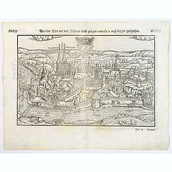
Die statt Eger vor dem Bohemer wald gelegen conrafhe et nach jetziger gelegenheit..
An attractive, large, early woodcut view of Cheb (Eger) in the Karlovy Vary region of the Czech Republic by Sebastian Munster on a full double sheet. Title and a descript...
Date: Basle, 1574
Selling price: ????
Please login to see price!
Sold in 2020
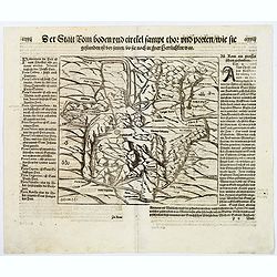
Die Statt Rom boden und circkel sampt thor. . .
An early woodcut map of the ancient Rome by Sebastian Münster. From the German edition of Sebastian Münster's Cosmography, titled Cosmographey oder beschreibung aller L...
Date: Basle, 1574
Selling price: ????
Please login to see price!
Sold in 2020
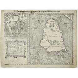
Sumatra ein grosse Insel, so von den alten Geographen Taprobana, ist genent worden (Sri Lanka).
A nice impression of this great map of island of Tabrobana, which was variously thought to be Ceylon or Sumatra. This map depicts Ceylon with the typical misconceptions o...
Date: Basle, 1574
Selling price: ????
Please login to see price!
Sold in 2021
Die statt Montpellier . . .
Panoramic view of Montpellier by Sebastian Münster. Title and a description of the city on verso. With a lettered key underneath the engraving. From the German edition o...
Date: Basel, 1574
Selling price: ????
Please login to see price!
Sold in 2019
Die neüwen Inseln/ so hinder Hispanien gegen Orient bey dem land Indie ligen.
The earliest and one of the most important separate maps to show both Americas. Although it was not the first map to use “America” as a designation for the New World,...
Date: Basle, 1574
Selling price: ????
Please login to see price!
Sold in 2019
![[Algiers].](/uploads/cache/14175-250x250.jpg)
[Algiers].
On recto an early representation of Algiers (142x185 mm). On verso a representation of a sword and a corona.From a French text edition of his Cosmographia , that great co...
Date: Basle, after 1575
Selling price: ????
Please login to see price!
Sold in 2012
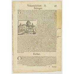
De la Cosmographie. Rauenne. Boloigne.
Text page with imaginary town views of Bologna and Ravenna.From a French text edition of his Cosmographia , that great compendium of Renaissance knowledge. In 1575 Sebast...
Date: Basle, ca. 1575
Selling price: ????
Please login to see price!
Sold in 2012
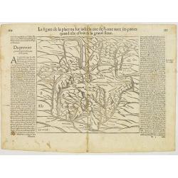
La figure de la place ou sut iadiz la cite de Rome avec ses portes quand elie estoit en sa grand fleur.
Plan of ancient Rome. On recto a child coming out of a bull. From a French text edition of his Cosmographia , that great compendium of Renaissance knowledge. In 1575 Seba...
Date: Basle, ca.1575
Selling price: ????
Please login to see price!
Sold in 2012
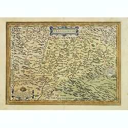
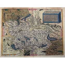
Transilvania.
Detailed map of Hungary prepared by Sambucas in 1566, who itself based his map on Honter's map of 1532.Latin text on verso.
Date: Antwerp, 1575
Selling price: ????
Please login to see price!
Sold
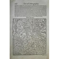
Moschouie.
Early woodcut map of the European part of Russia, centered on Moscow. The area shown extends to Kiev, the Sea of Azov, the Caspian Sea, the Ob River in Siberia, and borde...
Date: Basel, c1575
Selling price: ????
Please login to see price!
Sold in 2012
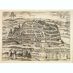
Bloys.
Early and detailed birds-eye town-view of Bloys. From the greatest publication in this genre!. The Civitates was compiled and written by George Braun, Canon of Cologne Ca...
Date: Cologne, 1575
Selling price: ????
Please login to see price!
Sold
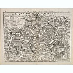
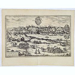
Le Vray pourtraict de la ville d'Aix en Provence.
A very decorative and rare town-plan of Aix en Provence from Franc¸ois de Belleforest's "La Cosmographie universelle de tout le monde". Paris, 1575. The book w...
Date: Nicolas Chesneau and Michel Sonnius, Paris,1575
Selling price: ????
Please login to see price!
Sold in 2012
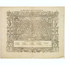
Le vif portaict de la noble ville, & cité de Tours.
Early bird's eye of Tours. In 1575 Sebastian Münster's Cosmographia was translated into French and published in Paris by François de Belle-Forest.
Date: Paris, 1575
Selling price: ????
Please login to see price!
Sold in 2012
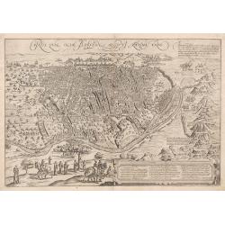
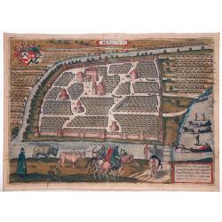
Grodna.
This is a stunning of what is now referred to today as Hrodna or Grodno, a city in Belarus. This image showings the city situated on the banks of the Neman River (called...
Date: Cologne, 1575
Selling price: ????
Please login to see price!
Sold in 2013
Cairus, quae olim Babylon , Aegypti Maxima Urbs.
Bird's-eye view of Cairo with key to locations.The Civitates was compiled and written by George Braun, Canon of Cologne Cathedral. Braun gathered together vast amounts of...
Date: Cologne, c.1575
Selling price: ????
Please login to see price!
Sold in 2013
Leyda, Batavorum Lugdumum, vulgo Leyden.. (Leiden)
A bird's-eye view of Leiden, Voorschoten, Zoeterwoude and Leiderdorp. From the greatest publication in this genre!. The Civitates was compiled and written by George Braun...
Date: Cologne, 1575
Selling price: ????
Please login to see price!
Sold in 2013
Augusta iuxta figuram quam his ce temporibus habet delineata
A bird's-eye of Augsburg, with a numbered key in the lower left corner (1-133) shows the individual groups of buildings very clearly, including the Fuggerei (72, bottom ...
Date: Cologne, 1575
Selling price: ????
Please login to see price!
Sold in 2013
(Arch of Noah.)
Wood block engraved print of the Arch of Noah, from "La Cosmographie Universelle de Tout le Monde", the French and most extended edition of Sebastian Münster's...
Date: Paris, Nicolas Chesneau, 1575
Selling price: ????
Please login to see price!
Sold in 2014
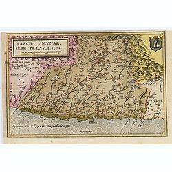
Marcha Anconae, olim Picenum. 1572.
The Ancona region along the coast of the Adriatic Sea. Oceans, mountains, rivers, lakes, cities and important towns are detailed. No text on verso.Taken from a larger she...
Date: Antwerp, 1574-1575
Selling price: ????
Please login to see price!
Sold in 2017
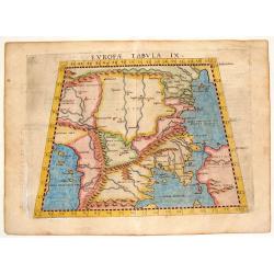
Europae Tabula IX.
One of the earliest maps of Turkey and Macedonia. From Girolamo Ruscelli's edition of "Ptolemy's Geographia". The map is drawn on the trapezoidal projection and...
Date: Venice, 1575
Selling price: ????
Please login to see price!
Sold in 2014
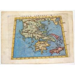
Tabula Europae X - (Greek Islands)
One of the earliest maps of the Greek Islands. From Girolamo Ruscelli's edition of "Ptolemy's Geographia". The woodcut map is drawn on the trapezoidal projectio...
Date: Venice, 1575
Selling price: ????
Please login to see price!
Sold in 2013
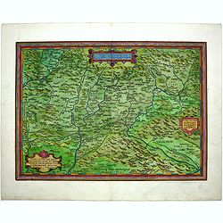
Helvetiae Descriptio Aegidio Tschudo Auct.
Attractive early map of Switzerland. Includes parts of Italy as far south as Milan and Cremona, with the Lago Maggiore, Lago di Lugano, Lago di Como, and Lago d'Iseo. Nor...
Date: Antwerp, ca. 1575
Selling price: ????
Please login to see price!
Sold in 2013
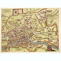
Urbis Romae situs que adhuc conspiuntur..
A bird's-eye view of Rome during the year 1570, 3 local figures lower right. From the greatest publication in this genre!. The Civitates was compiled and written by Georg...
Date: Cologne, 1575
Selling price: ????
Please login to see price!
Sold in 2014
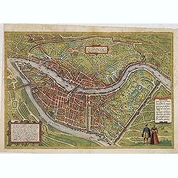
Lugdunum.
Bird's eye view of Lyon.
Date: Cologne, ca. 1575
Selling price: ????
Please login to see price!
Sold in 2014
Europe.
Uncommon wood-cut map of Europe. The surrounding sea is cut in very great detail. The seas are teeming with numerous small sailing vessels of different shapes and sizes t...
Date: Paris, 1575
Selling price: ????
Please login to see price!
Sold in 2014
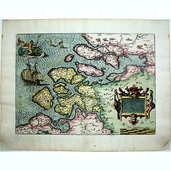
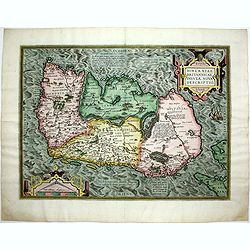
Zelandicarum Insularum Exactissima et Nova Descriptio.
Striking map of Zeeland from 'Theatrum Orbis Terrarum [Atlas of the Whole World]',by Ortelius, Latin ed, pl. 39, CN no. 18.The Theatrum was re-issued in 42 editions with ...
Date: Antwerp, 1575
Selling price: ????
Please login to see price!
Sold in 2015
Transilvania.
Detailed map of Hungary prepared by Sambucas in 1566, who itself based his map on Honter's map of 1532.Dutch text on verso.
Date: Antwerp, 1575
Selling price: ????
Please login to see price!
Sold in 2014
Asie.
Scarce wood-cut map of Asia. New Guinea has disappeared and Japan is represented as a turtle-shaped island. An important innovation is the appearance of the Straits of An...
Date: Paris, 1575
Selling price: ????
Please login to see price!
Sold in 2017
Transilvania.
Detailed map of Hungary prepared by Sambucas in 1566, who itself based his map on Honter's map of 1532.Latin text on verso.
Date: Antwerp, 1575
Selling price: ????
Please login to see price!
Sold in 2015
![[Kings of the Ottoman Empire].](/uploads/cache/14188-250x250.jpg)
[Kings of the Ottoman Empire].
On recto an early representation of the first Ottoman King of the dynasty (112x65 mm). On verso a portrait of Orchanes, second king (80x50 mm), and of Amurathes, third ki...
Date: Basle, about or after 1575
Selling price: ????
Please login to see price!
Sold in 2020
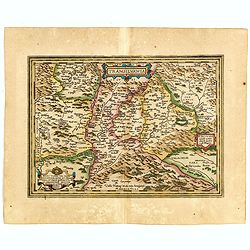
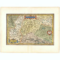
POLONIAE finitimarumque locorum descrip:tio. Auctore WENCESLAO GRODECCIO. Polono.
Ortelius' evocative map of Poland, being a close copy of Grodecki / Pograbka's map of 1558/62 map, itself based on Wapovsky 1526 (Karrow 56) With Latin text on verso, a s...
Date: Antwerp, 1575
Selling price: ????
Please login to see price!
Sold in 2016
Transilvania.
Detailed map of Hungary prepared by Sambucas in 1566, who itself based his map on Honter's map of 1532.Latin text on verso.
Date: Antwerp, 1575
Selling price: ????
Please login to see price!
Sold in 2015
MOSCAVW
From the famous 'Civitates Orbis Terrarum' of Braun and Hogenberg, one of the most sought after early views of Moscow.It depicts the city from an elevated viewpoint acros...
Date: Cologne, 1575
Selling price: ????
Please login to see price!
Sold in 2015
Augustodunum Flauia Heduorum.
A fine engraved view of the city of Autun, in France, on the Loire River. Taken from the Latin edition of George Braun and Frans Hogenberg's landmark "Civitates Orbi...
Date: Cologne, 1575
Selling price: ????
Please login to see price!
Sold in 2017
Ormus.
A scarce and early woodcut view of Hormuz, an island in the Strait of Hormuz, belonging to Iran. On the full text sheet. Based on the Hormuz view of Braun and Hogenberg. ...
Date: Paris, 1575
Selling price: ????
Please login to see price!
Sold in 2016