Browse Listings
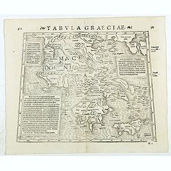
Tabula Graeciae. (Greece and Greek islands)
Double-page woodcut Ptolemaic-style map by Sebastian Münster figuring Greece, published in the edition of Strabo by Henri Petri in 1571."Strabonis rerum geographica...
Date: Basle, Henri Petri, 1571
Selling price: ????
Please login to see price!
Sold in 2018
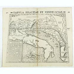
Tabula Rhaetiae et Vindeliciae. (Adriatic coast and Balkan States, Dalmatia, etc.)
Double-page woodcut Ptolemaic-style map by Sebastian Münster figuring Adriatic coast and Balkan States, Dalmatia, etc., published in the edition of Strabo by Henri Petri...
Date: Basle, Henri Petri, 1571
Selling price: ????
Please login to see price!
Sold in 2018
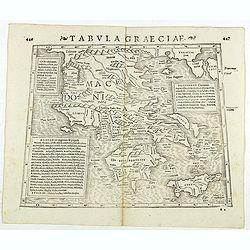
Tabula Graeciae. (Greece)
Double-page woodcut Ptolemaic-style map by Sebastian Münster figuring Greece and Greek islands, published in the edition of Strabo by Henri Petri in 1571."Strabonis...
Date: Basle, Henri Petri, 1571
Selling price: ????
Please login to see price!
Sold in 2018
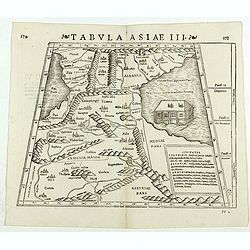
Tabula Asiae III. (Armenia)
Double-page woodcut Ptolemaic-style map by Sebastian Münster figuring Armenia, published in the edition of Strabo by Henri Petri in 1571."Strabonis rerum geographic...
Date: Basle, Henri Petri, 1571
Selling price: ????
Please login to see price!
Sold in 2018
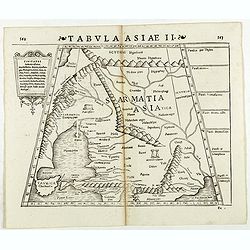
Tabula Asiae II. (Ukraine)
Double-page woodcut Ptolemaic-style map by Sebastian Münster figuring Ukraine, published in the edition of Strabo by Henri Petri in 1571."Strabonis rerum geographic...
Date: Basle, Henri Petri, 1571
Selling price: ????
Please login to see price!
Sold in 2018
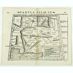
Tabula Asiae IX. (Pakistan, including part of India)
Double-page woodcut Ptolemaic-style map by Sebastian Münster figuring Pakistan, including part of India, published in the edition of Strabo by Henri Petri in 1571."...
Date: Basle, Henri Petri, 1571
Selling price: ????
Please login to see price!
Sold in 2019
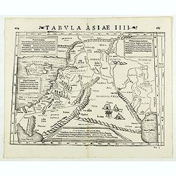
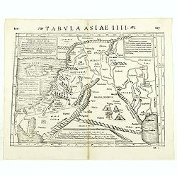
Tabula Asiae IIII. (Holy Land)
Double-page woodcut Ptolemaic-style map by Sebastian Münster figuring Holy Land, published in the edition of Strabo by Henri Petri in 1571."Strabonis rerum geograph...
Date: Basle, Henri Petri, 1571
Selling price: ????
Please login to see price!
Sold in 2019
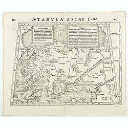
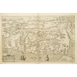
Tabula Asiae I. (Turkey)
Double-page woodcut Ptolemaic-style map by Sebastian Münster figuring Turkey, published in the edition of Strabo by Henri Petri in 1571."Strabonis rerum geographica...
Date: Basle, Henri Petri, 1571
Selling price: ????
Please login to see price!
Sold in 2018
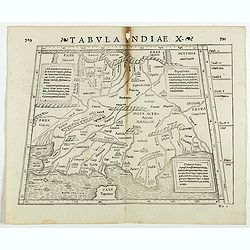
Tabula Indiae X. (part of India and the Indian Ocean)
Double-page woodcut Ptolemaic-style map by Sebastian Münster figuring part of India and the Indian Ocean, published in the edition of Strabo by Henri Petri in 1571."...
Date: Basle, Henri Petri, 1571
Selling price: ????
Please login to see price!
Sold in 2022
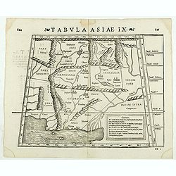
Tabula Asiae IX. (North India and Pakistan)
Double-page woodcut Ptolemaic-style map by Sebastian Münster figuring North India and Pakistan, published in the edition of Strabo by Henri Petri in 1571."Strabonis...
Date: Basle, Henri Petri, 1571
Selling price: ????
Please login to see price!
Sold in 2020
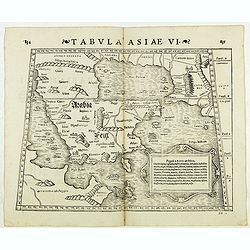
Tabula Asiae VI. ( Arabian Peninsula)
Double-page woodcut Ptolemaic-style map by Sebastian Münster figuring Arabian Peninsula, published in the edition of Strabo by Henri Petri in 1571."Strabonis rerum ...
Date: Basle, Henri Petri, 1571
Selling price: ????
Please login to see price!
Sold in 2018
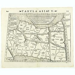
Tabula Asiae V. ( Eastern Iraq and western Iran)
Double-page woodcut Ptolemaic-style map by Sebastian Münster figuring Eastern Iraq and western Iran, published in the edition of Strabo by Henri Petri in 1571."Stra...
Date: Basle, Henri Petri, 1571
Selling price: ????
Please login to see price!
Sold in 2019
Tabula Asiae IIII. ( Holy Land, Cyprus, Syria, etc.)
Double-page woodcut Ptolemaic-style map by Sebastian Münster figuring Holy Land, Cyprus, Syria, etc., published in the edition of Strabo by Henri Petri in 1571."Str...
Date: Basle, Henri Petri, 1571
Selling price: ????
Please login to see price!
Sold in 2018
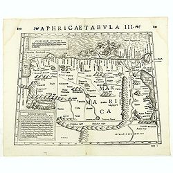
Aphricae Tabula III. (North Africa and Egypt)
Double-page woodcut Ptolemaic-style map by Sebastian Münster figuring North Africa and Egypt., published in the edition of Strabo by Henri Petri in 1571."Strabonis ...
Date: Basle, Henri Petri, 1571
Selling price: ????
Please login to see price!
Sold in 2018
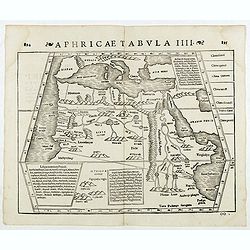
Aphricae Tabula IIII. (North Africa and the Mediterranean)
Double-page woodcut Ptolemaic-style map by Sebastian Münster figuring North Africa and the Mediterranean, published in the edition of Strabo by Henri Petri in 1571."...
Date: Basle, Henri Petri, 1571
Selling price: ????
Please login to see price!
Sold
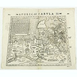
Aphricae Tabula II. (Northern Africa and the Mediterranean showing parts of Sicily, Tunisia and Libya)
Double-page woodcut Ptolemaic-style map by Sebastian Münster figuring Northern Africa and the Mediterranean showing parts of Sicily, Tunisia and Libya, published in the ...
Date: Basle, Henri Petri, 1571
Selling price: ????
Please login to see price!
Sold in 2018
![[Cyprus].](/uploads/cache/41984-250x250.jpg)
[Cyprus].
Woodcut Ptolemaic-style map by Sebastian Münster figuring Cyprus, published in the edition of Strabo by Henri Petri in 1571."Strabonis rerum geographicarum" is...
Date: Basle, Henri Petri, 1571
Selling price: ????
Please login to see price!
Sold in 2018
![[Rhodus].](/uploads/cache/41985-250x250.jpg)
[Rhodus].
Woodcut Ptolemaic-style map by Sebastian Münster figuring Rhodes Island, published in the edition of Strabo by Henri Petri in 1571."Strabonis rerum geographicarum&q...
Date: Basle, Henri Petri, 1571
Selling price: ????
Please login to see price!
Sold in 2018
![[Lesbos].](/uploads/cache/41986-250x250.jpg)
[Lesbos].
Woodcut Ptolemaic-style map by Sebastian Münster figuring Lesbos Island, published in the edition of Strabo by Henri Petri in 1571."Strabonis rerum geographicarum&q...
Date: Basle, Henri Petri, 1571
Selling price: ????
Please login to see price!
Sold in 2018
![[Creta].](/uploads/cache/41987-250x250.jpg)
[Creta].
Woodcut Ptolemaic-style map by Sebastian Münster figuring Crete Island, published in the edition of Strabo by Henri Petri in 1571."Strabonis rerum geographicarum&qu...
Date: Basle, Henri Petri, 1571
Selling price: ????
Please login to see price!
Sold in 2018
![[Cephaelenia].](/uploads/cache/41988-250x250.jpg)
[Cephaelenia].
Woodcut Ptolemaic-style map by Sebastian Münster figuring Cephalonia or Kefalonia Island, published in the edition of Strabo by Henri Petri in 1571."Strabonis rerum...
Date: Basle, Henri Petri, 1571
Selling price: ????
Please login to see price!
Sold in 2018
![[Title page of Theatrum Orbis Terrarum.]](/uploads/cache/81959-250x250.jpg)
[Title page of Theatrum Orbis Terrarum.]
Title page of "Theatrum Orbis Terrarum" verso text EPIGRAMMA DANIELIS ROGERII ALBIMONTANI, A decorative title page from Ortelius's first atlas. Latin Edition.
Date: Antwerp, 1571
Selling price: ????
Please login to see price!
Sold in 2020
![[Creation of earth]](/uploads/cache/32160-250x250.jpg)
[Creation of earth]
RECTO: A wood block print of visualizing the creation of earth.Text page taken from Sebastian Münster's encyclopedic work, the Cosmographia Universalis. The Cosmographia...
Date: Basle, 1572
Selling price: ????
Please login to see price!
Sold in 2012
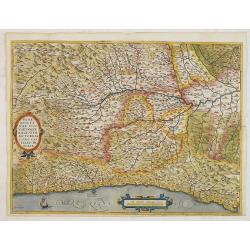
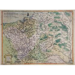
Pedemontanae Vicinorumque Regionum.
Fine map including the Italian coast from Monaco through Genoa to Rapallo, the map shows the Po River. Milan in the upper right-hand corner and Turin in the center of the...
Date: Antwerp, 1572
Selling price: ????
Please login to see price!
Sold in 2015
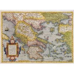
Graeciae Universae Secundum Hodiernum Situm Neoterica..
Ortelius' fine map of Greece, based on Jacobo Gastaldi's map of 1560. First state with the uncorrected scale bar numeral ( . . . 80-90-10.)
Date: Antwerp, 1572
Selling price: ????
Please login to see price!
Sold in 2012
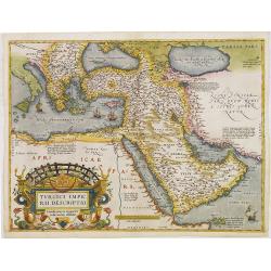
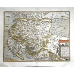
Turcici Imperii Descriptio.
This is Ortelius uncommon first map of the Turkish Empire only used from 1570 until 1579. This is the best known of all the sixteenth-century maps of the Middle East, ext...
Date: Antwerp, 1572
Selling price: ????
Please login to see price!
Sold in 2012
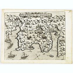
Provincia Di Albania.
An uncommon map of Albania, from Giovanni Francesco Camocio's rare " Isole Famose porti, fortezze, e terre maritime . . ." This plate was made by Giovanni Franc...
Date: Venice, 1572
Selling price: ????
Please login to see price!
Sold in 2012
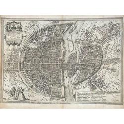
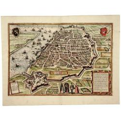
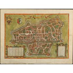
Lutetia vulgari Nomine Paris, Urbs Galliae Maxima ...
Based on Sebastian Munster's map of 1569, this exceptional town plan of 16th Century Paris depicts in details the city as it evolved from a small settlement on an island ...
Date: Cologne, 1572
Selling price: ????
Please login to see price!
Sold in 2012
ANVERPIA
Superb bird's-eye plan of Antwerp. Highly detailed plan showing the town with buildings, streets, places, churches and squares. The river and the harbour are filled with ...
Date: Cologne, ca. 1572
Selling price: ????
Please login to see price!
Sold in 2014
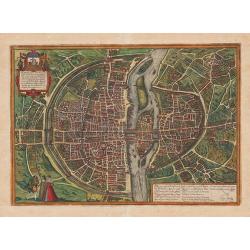
Lutetia vulgari Nomine Paris, Urbs Galliae Maxima, ...
Based on Sebastian Munster's map of 1569, this exceptional town plan of 16th Century Paris depicts in details the city as it evolved from a small settlement on an island ...
Date: Cologne, c.1572
Selling price: ????
Please login to see price!
Sold in 2013
Nimes and Bordeaux.
Text in top frame: "Rotomagus, vulgo Roan, Normandiae Metropolis depingebat Georgius Hoefnagle, cum privilegio."Lower Left Frame - Text: "Nemausus; Nismes ...
Date: Cologne, ca. 1572
Selling price: ????
Please login to see price!
Sold in 2013
Polna vulgo Polm insign : Bohemia.
RARE only included in part VI of his town book. Bird's-eye of Polna in Bohemia by G. Hoefnagel and son, 1617. Key to six locations.Frans Hogenberg (1535 Mechelen - Colog...
Date: Cologne, ca. 1572
Selling price: ????
Please login to see price!
Sold in 2020
Mexico. & Cusco regni Peru in novo orbe caput.
From part one of the "Civitates", the only view in the entire work to depict cities of the New World. Shown here are the great cities of the Aztec and Inca cult...
Date: Cologne, ca. 1572
Selling price: ????
Please login to see price!
Sold in 2013
Anverpia.
Superb bird's-eye plan of Antwerp. Highly detailed plan showing the city with buildings, streets, places, churches and squares. The river and the harbour are filled with ...
Date: Cologne, ca. 1572
Selling price: ????
Please login to see price!
Sold in 2013
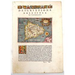
Descrittione del l'Isola di Taprobana.
Charming map of the island of Sri Lanka (Celon). The map is oriented with north to the right. Fancy strapwork cartouche with two faces and a unique compass rose. Printed ...
Date: Venice, 1572
Selling price: ????
Please login to see price!
Sold in 2013
Poloniae finitimarumque locorum descriptio. Auctore Wenceslao Godreccio Polono.
Early map of Poland, Lithuania, parts of Belarus, and the Ukraine, first issued 1570 and replaced 1595. This map has been published in the "Theatrum Orbis Terrarum&...
Date: Antwerp, c1572
Selling price: ????
Please login to see price!
Sold in 2013
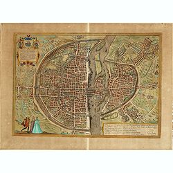
Lutetia, vulgari nomine Paris, urbs Gallia...
Beautiful and early town-plan of Paris with title cartouche and figures in the foreground. The Bastille is shown at the upper center of the engraving and the Notre-Dame c...
Date: Cologne, ca. 1572
Selling price: ????
Please login to see price!
Sold in 2020
![Mexico regia et celebris Hispaniae Novae civitas [with] Cusco regni Peru in novo orbe caput.](/uploads/cache/36845-250x250.jpg)
Mexico regia et celebris Hispaniae Novae civitas [with] Cusco regni Peru in novo orbe caput.
From part one of the "Civitates", the only view in the entire work to depict cities of the New World. Shown here are the great cities of the Aztec and Inca cult...
Date: Antwerp, 1572
Selling price: ????
Please login to see price!
Sold in 2017
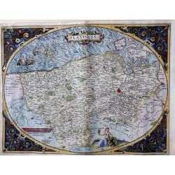
Flandria
A very decorative, unusual, egg-shaped map of Flanders. This is the early state with the farmer's wife and three ships in the North Sea. Nice colors, enhanced by gold.
Date: Antwerp, 1572
Selling price: ????
Please login to see price!
Sold in 2018
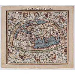
Ptolemeisch General Tafel, die Halbe Kugel der Welt Begreiffende​.
The second ancient map of the World, based upon the writings of Ptolemy. This map by Sebastian Münster features 12 wind heads and other classic pre-Columbian beliefs abo...
Date: Basle, 1572
Selling price: ????
Please login to see price!
Sold in 2018
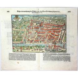
Wahre abcontrasehtung der Loblichen und alten Statt Solothurn / gelegen in der Eydtgnoschaffe an der Uar
A double page bird’s-eye map of Solothurn, town on the Aar River in Switzerland. Solothurn is considered by many to be the most beautiful baroque city in Switzerland. T...
Date: Basel, 1572
Selling price: ????
Please login to see price!
Sold in 2016
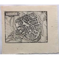
Beaumont en Hainaut.
A bird's-eye plan of Beaumont south of Charleroi, near Walcourt, in Belgium. Walls and a moat protect the city.It provides an excellent view of the city's defences, bridg...
Date: Amsterdam, 1572
Selling price: ????
Please login to see price!
Sold in 2018

Bruxella...
A highly detailed 16th-century plan of Brussels with numerous buildings, streets, places, churches, and squares. Further with the city walls and bridges across the river,...
Date: Cologne, c1572
Selling price: ????
Please login to see price!
Sold in 2017
Hypra Flandriarum Civitas Munitissima.
A very detailed, panoramic view of Leper, from Braun & Hogenberg’s “Civitates Orbis Terrarum." This town is located in Belgium, on the border with France. Po...
Date: Cologne, 1572
Selling price: ????
Please login to see price!
Sold in 2020
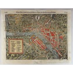
Bende Statt Basel mit dem Furssiessenden Rhein.
Fine double page wood block bird's-eye view of the fortified city of Basel, Switzerland. An original wood engraved map from the “COSMOGRAPHIA UNIVERSALIS” by Sebastia...
Date: Basel, 1572
Selling price: ????
Please login to see price!
Sold in 2018
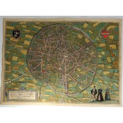
Lovanium Brabanticarum Urbium Caput. . .
A lovely birds-eye view of Louvain with detail even of single buildings. Translated “Louvain, capital of Brabant, unrivalled site of the muses and the most distinguishe...
Date: Cologne, 1572
Selling price: ????
Please login to see price!
Sold in 2018
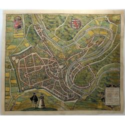
Lutzenburgum Ducatus Eiusdem Nominus. . .
A lovely birds-eye view of Luxemburg with detail even of single buildings. Translated “Luxembourg, old capital of the duchy of the same name, it was once noteworthy on...
Date: Cologne, 1572
Selling price: ????
Please login to see price!
Sold in 2018
Atrebatum Episcopa Lis et Metropolica Artesiae Vivitas.
An early city views of Arras, in the Nord-Pas-de-Calais, North of France, from an early edition of Braun & Hogenberg's Civitates Orbis Terrarum, the most prolific com...
Date: Cologne, 1572
Selling price: ????
Please login to see price!
Sold in 2018
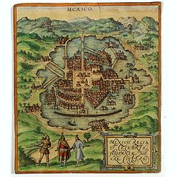
Mexico regia et celebris Hispaniae Novae civitas.
One of the earliest prints of Mexico City and taken from part one of the "Civitates", the only view in the entire work to depict cities of the New World. The vi...
Date: Antwerp, 1572
Selling price: ????
Please login to see price!
Sold in 2018
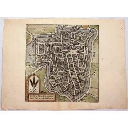
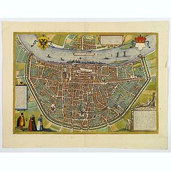
![Traejectum [Utrecht].](/uploads/cache/81839-250x250.jpg)
Traejectum [Utrecht].
An early plan of Utrecht depicting many structures dating back to the early Middle Ages, notably the centrally-located Dom Church, then known as the Cathedral of Saint Ma...
Date: Cologne, 1572
Selling price: ????
Please login to see price!
Sold in 2018
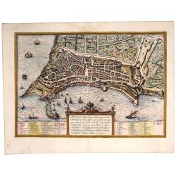
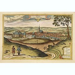
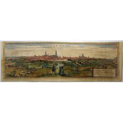
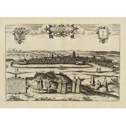
Ancona civitas. (Port of Ancona in a first edition)
Fine first issue of one of this very attractive, early view of Ancona, one of the principal Italian ports on the Adriatic sea. The city’s distinctive harbor is shown te...
Date: Cologne, 1572
Selling price: ????
Please login to see price!
Sold in 2018
Colonia Agrippina.
A bird's-eye view of the city of Cologne. With a strapwork title cartouche, and many figures.From the greatest publication in this genre!. The Civitates was compiled and ...
Date: Cologne, 1572
Selling price: ????
Please login to see price!
Sold in 2020
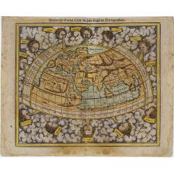
Ptolemeisch General Tafel, die Halbe Kugel der Welt Begreiffende​.
The second ancient map of the World, based upon the writings of Ptolemy. This map by Sebastian Münster features 12 wind heads and other classic pre-Columbian beliefs abo...
Date: Basle, 1572
Selling price: ????
Please login to see price!
Sold in 2019
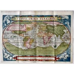
Typus Orbis Terrarum.
Ortelius' Landmark World Map - 1st state, 1st Edition. French text on verso. One of the most famous world maps ever made, "Typus Orbis Terrarum" featured in the...
Date: Antwerp, 1572
Selling price: ????
Please login to see price!
Sold in 2019
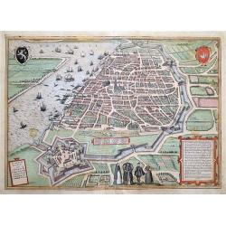
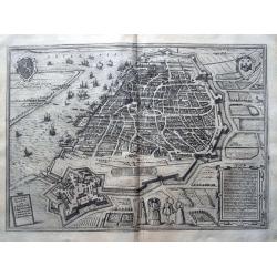
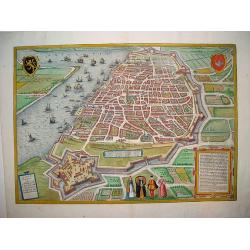
Anverpia, nobile in Brahantia . . .
A Very Early Plan of Antwerp - an Excellent Example. First issue. A beautiful, well-detailed glimpse of Antwerp, portrayed prior to the Spanish Fury when it was a great c...
Date: Cologne, 1572
Selling price: ????
Please login to see price!
Sold in 2019
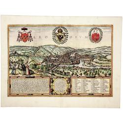
Liege. Leodium... Civitatis Leodiensis Genuina Delineatio.
A Very Early Plan of Liege - an Excellent Example. Earliest issue of the earliest acquirable, detailed view of Liege, showing the walled city in rich detail. With 64 spec...
Date: Cologne, 1572
Selling price: ????
Please login to see price!
Sold in 2019
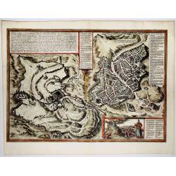
Hierosolyma, Clarrisima Totius Orientis Civitas ludaee Metropolis... (Jerusalem)
A very fine, decorative map with a double-view of Jerusalem depicts Biblical Jerusalem and the modern city during the 16th century. Biblical Jerusalem appears on the left...
Date: 1572
Selling price: ????
Please login to see price!
Sold in 2019

Africae Tabula Nova.
The title is contained in a striking cartouche consisting of a panel flanked by caryatids and strapwork. The sea is engraved in stipple-work, and features a sea-battle in...
Date: Antwerp 1572
Selling price: ????
Please login to see price!
Sold
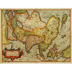
Asiae nova descriptio.
Ortelius' fine map of Asia well represents the continent at a time when Europeans were expanding their power in the far east. The Indian subcontinent and Malaysian penins...
Date: Antwerp 1572
Selling price: ????
Please login to see price!
Sold
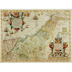
Palestinae sive totius terrae promissionis nova..
A new description of Palestine or the whole Promised Land. The shoreline runs from Berytus (Beirut) to the Nile Delta, reaching inland east of the Jordan and in the south...
Date: Antwerp 1572
Selling price: ????
Please login to see price!
Sold
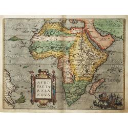
Africae Tabula Nova.
The title is contained in a striking cartouche consisting of a panel flanked by caryatids and strapwork. The sea is engraved in stipple-work, and features a sea-battle in...
Date: Antwerp 1572
Selling price: ????
Please login to see price!
Sold
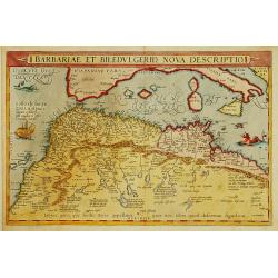
Barbariae et Biledulgerid, nova descriptio.
North-West Africa. Koeman speculated: ''In view of the important trading relationship between Antwerp and Africa, it is not impossible that the original was a manuscript ...
Date: Antwerp 1572
Selling price: ????
Please login to see price!
Sold
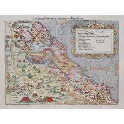
Das hehlig Judisch land mit. . .
This is Sebastian Munster's interesting and detailed double-page map of the Holy Lands from his Cosmographia. The map shows from Sidon and the land of the Phoenicians in...
Date: Basel, (1540) 1572
Selling price: ????
Please login to see price!
Sold in 2012
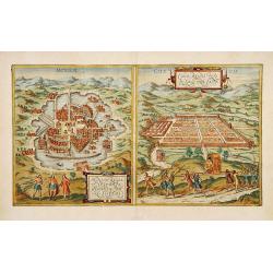
Mexico. & Cusco regni Peru in novo orbe caput.
From part one of the "Civitates", the only view in the entire work to depict cities of the New World. Shown here are the great cities of the Aztec and Inca cult...
Date: Antwerp, 1572
Selling price: ????
Please login to see price!
Sold
![[Descrittione del Mappamondo]](/uploads/cache/13376-250x250.jpg)
[Descrittione del Mappamondo]
From : "L'Isole piu Famose Del Mondo...",Large landmass above the north of the American continent called Grvtlandia.
Date: Venise, later than 1572
Selling price: ????
Please login to see price!
Sold
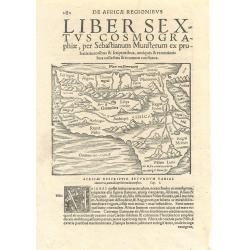
Africae Descriptio...
Munster's smaller woodcut map of Africa, printed area 130 x 160mm, set in a large page of text. From an Italian edition of the Cosmography. One of the earliest obtainable...
Date: Basle, 1572
Selling price: ????
Please login to see price!
Sold
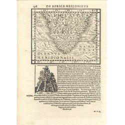
De Africae Regionibus
Munster's uncommon woodcut map of Southern Africa. Although numerous editions of the Cosmography were printed over the span of 50 years, this map appeared in only one edi...
Date: Basle, 1572
Selling price: ????
Please login to see price!
Sold
Tabula Terrae Canaan Abrahae tempore et ante adventum?
Map of Canaan at the times of Abraham and before the conquest by the Children of Israel, with the neighboring regions. Oriented to the east. The shore line runs from Turk...
Date: Antwerp, 1572
Selling price: ????
Please login to see price!
Sold
Dantzigt.
Copper engraving illustrating a general view of Gdansk (Danzig), from Civitates Orbis Terrarum.
Date: Cologne 1572
Selling price: ????
Please login to see price!
Sold
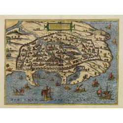
Alexandria vetustissimum AEgypti emporium
A superb image of Alexandria, the famous Egyptian center of learning. From Braun and Hogenberg's "Civitates Orbis Terrarum". An excellent example in fine period...
Date: Cologne, 1572
Selling price: ????
Please login to see price!
Sold in 2008
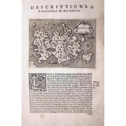
MAIORCA.
One of the earliest separate maps of Majorca (Mallorca)! First issue from 1572. The map shows major cities and several sea monsters. A compass rose orients the map with s...
Date: Venice, c1572
Selling price: ????
Please login to see price!
Sold in 2013
Anverpia, nobile in Barbantia oppidum, parrim maritimum...
This work is the smaller version of the two plans of Antwerp that were included in Braun & Hogenberg's great city atlas. The bird's-eye plan provides an excellent vie...
Date: Cologne, ca. 1572
Selling price: ????
Please login to see price!
Sold in 2008
Augusta iuxta figuram quam his ce temporibus habet delineata
Attractive cityview of Augsburg. Beautiful colored. Latin text on verso.
Date: Cologne, 1572
Selling price: ????
Please login to see price!
Sold in 2008
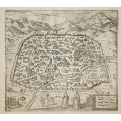
Damascus, urbs.
Early view of Damascus, a town-plan from the greatest publication in this genre !. The ,Civitates, was compiled and written by George Braun, Canon of Cologne Cathedral. B...
Date: Cologne 1572
Selling price: ????
Please login to see price!
Sold in 2011
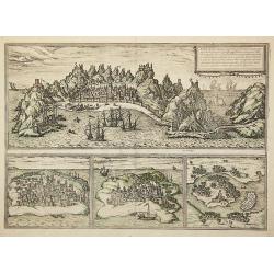
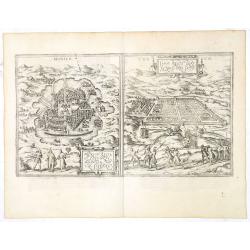
Aden, .../ Mambaza / Quilao / Cefala.
Four town-views of Middle Eastern and East African/Indian Ocean port cities once maintained by the Portuguese in the 16th century as strategic parts of the Lusitanian cro...
Date: Cologne, 1572
Selling price: ????
Please login to see price!
Sold in 2011
![Brilium, Hollandiae opp. [Briel]](/uploads/cache/15473-250x250.jpg)
Brilium, Hollandiae opp. [Briel]
One of the earliest bird's-eye views of Den Briel from the greatest publication in this genre !. The ,Civitates, was compiled and written by George Braun, Canon of Cologn...
Date: Cologne 1572
Selling price: ????
Please login to see price!
Sold in 2009
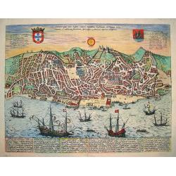
Olissippo quae numc Lisboa...
A beautiful bird's-eye town-view of Lisbon as seen in the 16th century. From the famous CIVITATES ORBIS TERRARUM, the first atlas dedicated to town plans on a global scal...
Date: Cologne, ca. 1572
Selling price: ????
Please login to see price!
Sold in 2009
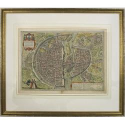
Lutetia, Vulgari Nomine Paris, Urbs Gallia Maxima, sequana navigabili flumine irrigatur. . . frequeta universitate excelenti, stupendi opera Tempso B. Maria..
Beautiful and early town-plan of Paris with title cartouche and figures in the foreground. The Bastille is shown at the upper center of the engraving and the Notre-Dame c...
Date: Cologne, ca. 1572
Selling price: ????
Please login to see price!
Sold
Illyricum.
Finely colored map of of Istria, Slovenia and Croatia by Abraham Ortelius. As noted in the lower right cartouche, this map was by Johann Sambucus in1572. Accompanying La...
Date: Antwerp, 1572
Selling price: ????
Please login to see price!
Sold in 2010
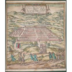
Cusco, Regni Peru in Novo Orbe Caput.
According to George Braun : "The capital of Peru in the south of the New world is Cusco, a city so large, powerful and beautiful that it can easily rank alongside th...
Date: Antwerp, 1572
Selling price: ????
Please login to see price!
Sold in 2014