Browse Listings
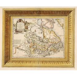
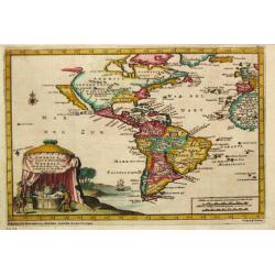
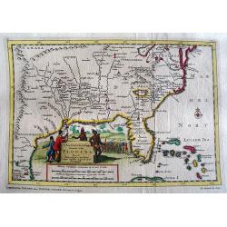
Canada ou Nouvelle France..
Uncommon map of Canada, including Great Lakes and East Coast down to Philadelphia. The map is printed within a large, elaborately engraved mock-frame border, which was pr...
Date: Amsterdam 1706
Selling price: ????
Please login to see price!
Sold
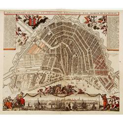
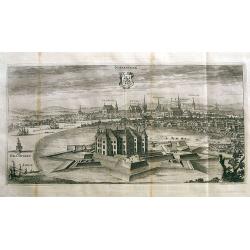
Amstelodami Veteris et Novissimi Delineatio..
A rare contemporary colored town-plan of Amsterdam with a panoramic inset view of the harbour and city. Jacob de la Feuille (1668-1719) was mapmaker, engraver and publish...
Date: Amsterdam 1706
Selling price: ????
Please login to see price!
Sold
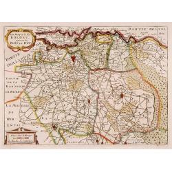
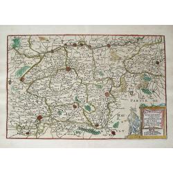
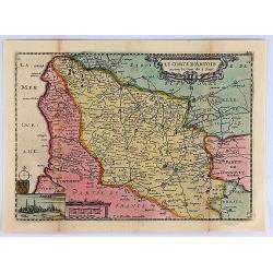
La Mayerie de BOLDVC, autrement dict Bois le Duc.
From his atlas Oorlogs tablessen, Oft uytgesochte Kaarten. Covering the so-called area Meierij van 's-Hertogenbosch. Eindhoven in the centre of the map.
Date: Amsterdam 1706
Selling price: ????
Please login to see price!
Sold
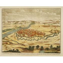
A view of Casal...
Decorative view of the italian city of Casal. engraved by J. Basire.
Date: London, 1706
Selling price: ????
Please login to see price!
Sold
![[Title page] Geographia Die Erd Beschreibung.](/uploads/cache/17479-250x250.jpg)
[Title page] Geographia Die Erd Beschreibung.
Decorative title page engraved by Johannes Meyer. In each corner 4 women representing the four continents, accompanied by native flora and fauna. In center an dramatic en...
Date: Zurich, 1706
Selling price: ????
Please login to see price!
Sold in 2008

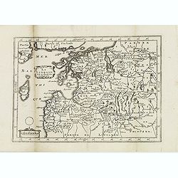
Carte de Tartarie..
Detailed map covering north east Asia, Tibet, Korea and part of Terre d' Eso . Nova Zembla joined with the mainland.
Date: Paris 1706
Selling price: ????
Please login to see price!
Sold
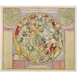
PLANISPHAERII COELESTIS HEMISPHAERIUM SEPTENTRIONALE?
A rare chart of the Northern skies, published in Allard's Atlas Coelestis. A visually striking example of this scarce and important map, in a first state. Later the chart...
Date: Amsterdam 1706
Selling price: ????
Please login to see price!
Sold
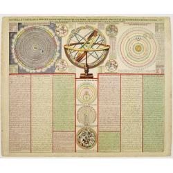
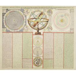
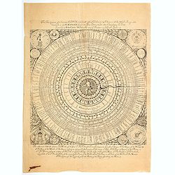
Nouvelle carte de la sphere pour faire connoitre les diver mouvemens des planetes et leurs diverses revolutions..
A rare print showing an armillary globe with smaller circular diagrams illustrating the theories of Ptolemy, Copernicus, Brahe and Descartes.The tables along the sides id...
Date: Amsterdam 1706
Selling price: ????
Please login to see price!
Sold
Carte de Tartarie. . .
Uncommon Amsterdam edition covering north east Asia, Tibet, Korea and part of Terre d'Eso . Nova Zembla joined with the mainland.
Date: Amsterdam, 1706
Selling price: ????
Please login to see price!
Sold in 2017
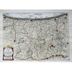
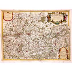
La Flandre Gallicane, Comprennant Le Chastellenie...
Small but very detailed map of the French and Belgian border region, with the fortified cites of Douai, Lille, Courtray, and Tournai. The map is embellished with an attra...
Date: Amsterdam, c1706
Selling price: ????
Please login to see price!
Sold in 2013
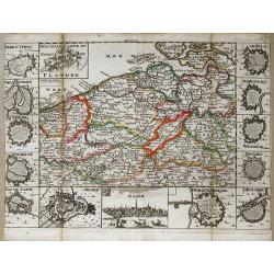
Partie de la Flandre Occidentale. . .
Very detailed map of western Flanders between Calais, Dunkerque, Omer, Ypres and Oostende. Shows many even smallest villages, roads, canals, settlements and fortification...
Date: Amsterdam, c1706
Selling price: ????
Please login to see price!
Sold in 2013
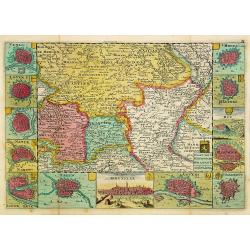
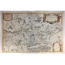
Nouvelle carte du Comte de Flandre.
A detailed map of the county of Flanders stretching from Dunkirk to the Schelde estuary. Surrounding the map are twelve towns plans: Berg St. Vinoc, Dendermonde, Ostende,...
Date: Amsterdam, 1706
Selling price: ????
Please login to see price!
Sold in 2013
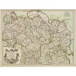
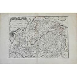
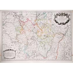
Kaart van 't Hertogdom Brabant.
From his atlas Oorlogs tablessen, Oft uytgesochte Kaarten. Covering the Dutch and Belgium province of Brabant and Limburg.Surrounded by 13 plans of the towns of 's-Hertog...
Date: Amsterdam 1706
Selling price: ????
Please login to see price!
Sold
Nouvelle carte de la sphere pour faire connoitre les diver mouvemens des planetes et leurs diverses revolutions..
A rare print showing an armillary globe with smaller circular diagrams illustrating the theories of Ptolemy, Copernicus, Brahe and Descartes.The tables along the sides id...
Date: Amsterdam, 1706
Selling price: ????
Please login to see price!
Sold in 2013
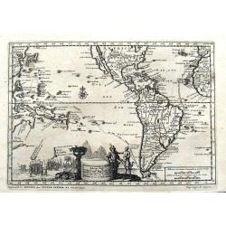
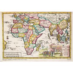
America, of Nieuw-Ontdekte Wereld, tot de Beschryving van Joseph d\'Acosta afgebakend.
Pieter van der Aa was a prolific publisher. He published a.o. ' Naauwkeurge versameling der gedenkwaardigste zee- en land-reysen', a series of accounts of voyages (1706-0...
Date: Leiden, 1706
Selling price: ????
Please login to see price!
Sold in 2010
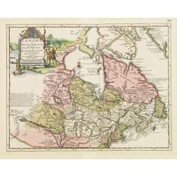
Canada ou Nouvelle France..
Uncommon map of Canada, including Great Lakes and East Coast down to Philadelphia.
Date: Amsterdam, 1706
Selling price: ????
Please login to see price!
Sold in 2008
![La Bretagne diviseé en ses neuf eveschés qui font aussi [. . .] generalité de Nantes. . .](/uploads/cache/25301-250x250.jpg)
La Bretagne diviseé en ses neuf eveschés qui font aussi [. . .] generalité de Nantes. . .
A large and most beautifully colored title cartouche with coats of arms: a very decorative map, engraved by Cordier. The map is dedicated to Pontchartain.The uncommon thi...
Date: Paris, 1706
Selling price: ????
Please login to see price!
Sold in 2008
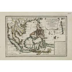
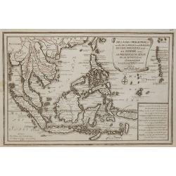
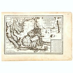
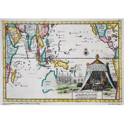
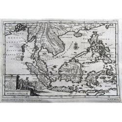
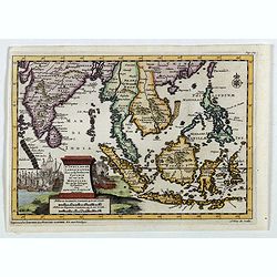
Les Isles Philippines et celles Des Larrons oude Marianes, Les Isles Moluques et de la Sonde, avec la Presqu'isle de L'Inde de la le Gange ou Orientale?
A map of the Malaysia, Indonesian and Philippines islands, by Nicolas De Fer, Royal French Geographer. The island of Taiwan is labeled "I.Formosa ou Bel Isle".
Date: Paris, 1706
Selling price: ????
Please login to see price!
Sold in 2015
Partie du Briançonnois, du Graisivaudan, du Gapençois et l'Ambrunois dans le Dauphiné.
Map of the Dauphiné region in France.
Date: Paris, 1706
Selling price: ????
Please login to see price!
Sold in 2009
Les Isles Philippines et celles Des Larrons oude Marianes, Les Isles Moluques et de la Sonde, avec la Presqu\'isle de L\'Inde de la le Gange ou Orientale.
A map of the Malaysia, Indonesian and Philippines islands, by Nicolas De Fer, Royal French Geographer. The island of Taiwan is labeled "I.Formosa ou Bel Isle".
Date: Paris, 1706
Selling price: ????
Please login to see price!
Sold in 2010
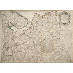
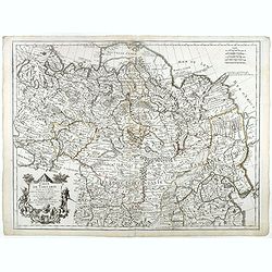
Carte de Moscovie.
Map of northwest region of Russia, including Russian Lapland and the White Sea, with a decorative cartouche in the upper right corner.
Date: Paris, 1706
Selling price: ????
Please login to see price!
Sold in 2010
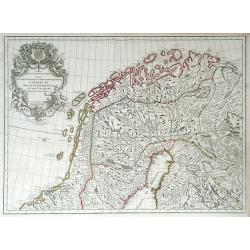
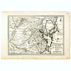
Carte des Courones du Nord Dediee Autres Puissant et tres Invincible Prince Charles XII Roy de Suede, des Gots et des Vandales
This is the top half of a two-part map of the larger Scandinavia/Russia region. This detailed map depicts Norway, Sweden, and Finland's northern areas and the Gulf of Bot...
Date: Paris, 1706
Selling price: ????
Please login to see price!
Sold in 2010
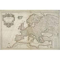
L'Europe divisee suivant l'estendue de ses principaux estats. . .
Fine map of Europe with a decorative title and scale cartouche. Prepared by Nicolas Sanson.Published by Alexis-Hubert Jaillot (1632-1712), who was a French cartographer. ...
Date: Paris, 1706
Selling price: ????
Please login to see price!
Sold in 2011
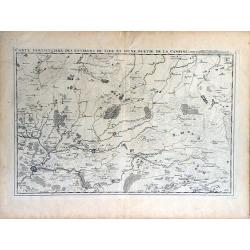
Carte Particuliere des Environs de Lier et d'Une Partie de la Campine.
Interesting map of the region of northern Belgium surrounding the town of Lier, including the Walloon region of La Bruyere (Bruyere) and part of the Campine region of nor...
Date: Brussels, 1706
Selling price: ????
Please login to see price!
Sold in 2010
La Castille Vieiele et Nouvelle L'Estramadura De Castille Et De Leon. . .
Beautiful, detailed map of the Leon and Castille regions of Spain by Nicholas de Fer. The cities of Madrid and Toledo are depicted, as well as the mountains, forests, riv...
Date: Paris, 1706
Selling price: ????
Please login to see price!
Sold in 2010
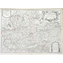
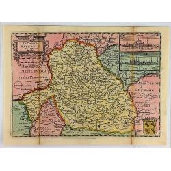
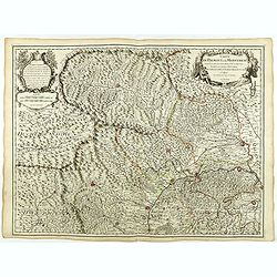
Carte des Comtez de Hainaut de Namur et de Cambresis. . .
Finely detailed map of the Walloon region, the regions of Hainaut, Namur and Cambresis, of southern Belgium by Guillaume de L'Isle. Cities, villages, rivers, forests and ...
Date: Paris, 1706
Selling price: ????
Please login to see price!
Sold in 2010
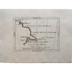
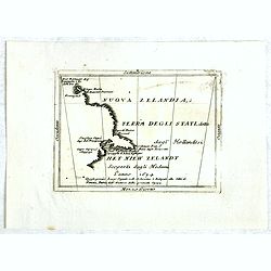
Nuova Zelandia, ò Terra Degli Stati, detta dagl'Hollandesi Het Niew Zelandt. scoperta dagli medemi l'anno 1654 . . .
Rare small map titled 'Nouva Zelanda, ò Terra Degli Stati, detta dagl'Hollandesi Het Niew Zelandt. scoperta dagli medemi l'anno 1654'. Earliest printed copper engraving ...
Date: Venice, 1706
Selling price: ????
Please login to see price!
Sold in 2019
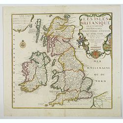
Les Isles Britanniques ou se trouvent Les Royaumes d'Angleterre, d'Ecosse et d'Irlande. . .
A nice, scarce large scale map of the British Isles by de Fer, published in Paris at the beginning of the 18th century. Outline color highlight the old Saxon, pre Norman ...
Date: Paris, 1706
Selling price: ????
Please login to see price!
Sold in 2020
The Frontispiece of a Curiouse CLOCK which will inform Gentlemen & Others in all Usefull Things Contained in ALMANACK'S for the Year 1701 . . .
RARE.One of the more obscure, but also one of the more fascinating historic horological texts was penned in the first decades of the 18th century by a London clock maker ...
Date: London, 1702 - 1706
Selling price: ????
Please login to see price!
Sold in 2020
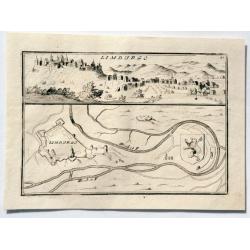
LIMBURGO.
An interesting simple city scene and map. This plate shows a view and a ground plan with fortifications of the Belgian city of Limbourg (Limburg). Vincenzo Coronelli (165...
Date: Venice, 1706
Selling price: ????
Please login to see price!
Sold in 2023
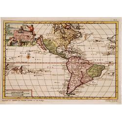
![L'AMERIQUE SEPTENTRIONALE.[California island]](/uploads/cache/85225-250x250.jpg)
L'AMERIQUE SEPTENTRIONALE.[California island]
A map of North and Central America showing California as a hugh island stretching as far north as Alaska with indented coastline, and with the place names of: R'Estiete, ...
Date: Amsterdam, 1706
Selling price: ????
Please login to see price!
Sold in 2021

Vincenzo Maria Coronelli
A wonderfully etched portret of Vincenzo Maria Coronelli (1650-1718), widely recognised as one of Italy's most famous and greatest cartographers, and cosmographer to t...
Date: Venice, 1706
Selling price: ????
Please login to see price!
Sold in 2022
![[Lot of 4] TURKEY](/uploads/cache/410004-250x250.jpg)
[Lot of 4] TURKEY
Pieter van der Aa (1659-1733) was a Dutch mapmaker and publisher who printed pirated editions of foreign bestsellers and illustrated books, but is best known for his vol...
Date: 1706
Selling price: ????
Please login to see price!
Sold in 2023
Norrkiöping.
Rare view of Norrköping in Sweden, with its "Star Fort" before it was destroyed during the Russian attack in 1719. Published by Erik Dahlberg. Highly detail...
Date: Stockholm, 1706
Selling price: ????
Please login to see price!
Sold in 2012
La Livonie. . .
A detailed map of Latvia and Estonia, centered on Riga. From his "Atlas Portatif, ou le nouveau Theatre de la Guerre en Europe, Contenants les cartes geographiques, ...
Date: Amsterdam, 1706
Selling price: ????
Please login to see price!
Sold in 2012
Carte des Comtez de Hainaut de Namur et de Cambresis.
Pleasing copper engraved, hand-colored map of Belgium and France featuring the cities of Douai, Landrecy, Namur, Brussels and Mons. Three decorative figural cartouches wi...
Date: Paris, 1706
Selling price: ????
Please login to see price!
Sold in 2016
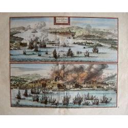
La Ville de Palimbang dans L'Ile de Sumatra.
A very decorative, impressive old-colored engraving of Palembang in Sumatra. Two views on one sheet. In the upper part the overall view with a sea battle in the foregroun...
Date: Leiden, 1706
Selling price: ????
Please login to see price!
Sold in 2014
Carte des Comtez de Hainaut de Namur et de Cambresis.
Striking copper engraved, hand-colored map of Belgium and France, featuring the cities of Douai, Landrecy, Namur, Brussels , Valencienes, and Mons.There are three decorat...
Date: Paris, 1706
Selling price: ????
Please login to see price!
Sold in 2018
Les Isles Philippines et celles Des Larrons ou de Marianes, Les Isles Moluques et de la Sonde, avec la Presqu'isle de L'Inde de la le Gange ou Orientale...
A scarce map of the Malaysia, Indonesian and Philippines islands, by Nicolas De Fer, Royal French Geographer. The island of Taiwan is labeled "I.Formosa ou Bel Isle&...
Date: Paris, 1706
Selling price: ????
Please login to see price!
Sold in 2016
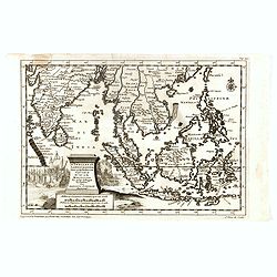
La partie orientale de l'Asie où se trouvent Le Grand Empire des Tartares Chinois et celuidu Iapon.
A map of China, Korea, Japan, Taiwan and northern India, by Nicolas De Fer, Royal French Geographer. The island of Taiwan is labeled "I.Formosa ou Bel Isle" and...
Date: Paris, 1706
Selling price: ????
Please login to see price!
Sold in 2018
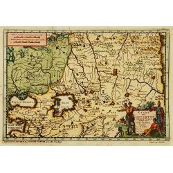
Perse (Persia)
A rare map of the Middle east region, Afghanistan and Persian Empire by a little known map maker - Medrano. Shows Kandahar, Kabu, Hormuz, Kurdistan and Isfahan in Iran.
Date: 1706
Selling price: ????
Please login to see price!
Sold in 2016
Nouva Zelanda, ò Terra Degli Stati, detta dagl'Hollandesi Het Niew Zelandt. scoperta dagli medemi l'anno 1654 . . .
RARE. This is the first printed map to dedicate to New Zealand, although the information dates back to Tasman in 1642. Showing from the Island of Three Kings to Cape Clip...
Date: Naples, 1706
Selling price: ????
Please login to see price!
Sold in 2016
Carte de Tartarie. . .
Covering north east Asia, Tibet, Korea and part of "Terre d'Eso". Nova Zembla joined with the mainland.With good detail in Korea, several cities a labeled: Chau...
Date: Paris, 1706
Selling price: ????
Please login to see price!
Sold
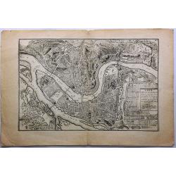
Lion, Ville Tres Considerable du Royaume.
This bird's-eye plan of Lion (Lyon) and vicinity illustrates the strategic position of its fortifications on the Saône and the Rhône rivers.It provides an excellent vie...
Date: Paris, 1706
Selling price: ????
Please login to see price!
Sold in 2019
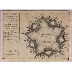
Citta Della Di Tournay.
The City of Tournay. This plate shows the fortifications of the Belgian city of Tournai (Doornik). The plate originates from 'Teatro della Guerra' by Coronelli in 1706.Vi...
Date: Venice, 1706
Selling price: ????
Please login to see price!
Sold in 2018
Le Comte de Haynault.
An interesting map of Haynault first drawn by Daniel de la Feuille in 1706. With ornamental title-cartouche, coat-of-arms and 2 views of the cities of Mons and Valencienn...
Date: Paris, 1706
Selling price: ????
Please login to see price!
Sold in 2018
Le Comte D'Artois.
An interesting map of Artois. France, first drawn by Daniel de la Feuille in 1706. With ornamental title-cartouche, title cartouche and view of the city of Abras. From �...
Date: Paris, 1706
Selling price: ????
Please login to see price!
Sold in 2019
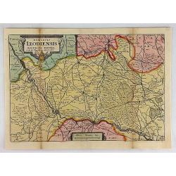
Diocesis Leodiensis Accurata Tabula.
A stunning map of Leodiensis, or the vicinity of Liege, Belgium, first drawn by Daniel de la Feuille in 1706. It depicts from Hoey in the west, eastwards as far as Peer, ...
Date: Paris, 1706
Selling price: ????
Please login to see price!
Sold in 2018
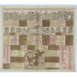
Germaniae Compendium Tria Continens Imperii Collegia. . .
An engraved chart listing the noble families and clergy of Germany, published by Schenk. The chart includes 15 large coats of arms of kings, bishops, dukes and counts, 20...
Date: Amsterdam, 1706
Selling price: ????
Please login to see price!
Sold in 2018
Carte de Tartarie . . .
Uncommon edition with the address : A Paris Chez l’Auteur sur le Quai de l’Horloge a l’Aigle d’Or avec Privilege, 1706". In early 1708 Delisle changed the si...
Date: Paris, 1706
Selling price: ????
Please login to see price!
Sold in 2018
![Carte des Courones du Nord. [2 sheets]](/uploads/cache/41938-250x250.jpg)
Carte des Courones du Nord. [2 sheets]
Two-sheet map of Denmark, Sweden, Finland and the Baltic states with the address : "Carte des Courones du Nord. Chez l’Auteur, Rue des Canétes prés St. Sulpice. ...
Date: Paris, 1706
Selling price: ????
Please login to see price!
Sold in 2025
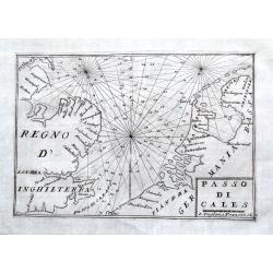
Passo di Cales.
A scarce sea-chart of the Southern Bight of the North Sea with parts of the Netherlands, Belgium, and Great Britain. With main coastal cities shown and many depth soundin...
Date: Venice, 1706
Selling price: ????
Please login to see price!
Sold in 2018
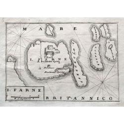
I. Farne.
A scarce map of the Farne Islands which are located off the coast of Northumberland! Published in Isole Britanniche. An apparently quite rare map, we can not find any oth...
Date: Venice, 1706
Selling price: ????
Please login to see price!
Sold in 2018
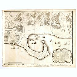
Plan of the Works of the city of Messina . . .
Fine bird's-eye plan of the city Messina. A decorative cartouche encloses a detailed key to the map that locates the castle, bastillon, armaments and government building...
Date: London, 1706
Selling price: ????
Please login to see price!
Sold in 2023
![Antique map of Scandinavia] Carte des Courones du Nord.](/uploads/cache/82019-250x250.jpg)
Antique map of Scandinavia] Carte des Courones du Nord.
[Antique map of Scandinavia] 'Carte des Courones du Nord', by Guillaume de l' Isle (1675-1724), a Royal Geographer. He was the most influential cartographer of the first ...
Date: Paris, 1706
Selling price: ????
Please login to see price!
Sold in 2020
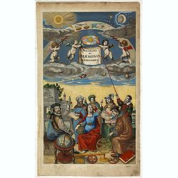
Atlas Coelestis seu Hormonia macrocosmica. (title page)
This elegant title page represents fully the contents of the book. The muse of astronomy, Urania, is surrounded by scientists, mathematicians and astronomers and celestia...
Date: Amsterdam, 1706
Selling price: ????
Please login to see price!
Sold in 2020
Scheeps-Togt door Ferdinand Magellaan. . .
A beautiful map illustrating the great voyage of Ferdinand Magellan from Spain, through the Straits of Magellan, through the Pacific, until Southeast Asia. The maps shows...
Date: Leiden, ca 1706
Selling price: ????
Please login to see price!
Sold in 2019
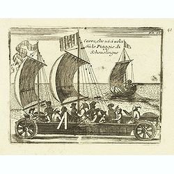
Carro, che uà à vela Su le Piagge di Schevelingue.
Italian version of Prince Maurits' sailing carriage designed by Simon Stevin. The big sailing-carriage could seat 28 persons and could reach a speed of seven miles per ho...
Date: Venice, 1707
Selling price: ????
Please login to see price!
Sold in 2012
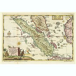
Het eiland Sumatra hoe ten aansien van Malacca . . .
Map of Sumatra, lower part of Malacca with Singapore (Singapura) and western part of Borneo. In lower left a fine title cartouche showing locals.Although not renowned for...
Date: Leiden, 1707
Selling price: ????
Please login to see price!
Sold in 2012
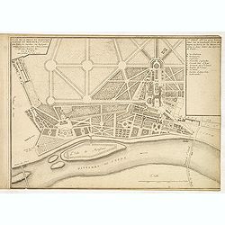
Plan de la belle et magnifique maison de Monsieur à St Cloud. . .
Garden plan in St. Cloud near Paris.
Date: Paris, 1707
Selling price: ????
Please login to see price!
Sold in 2013
La Lorraine.
Alexis-Hubert Jaillot (1632-1712), French cartographer. he joined the Sanson heirs. He redrew Nicolas Sanson's maps on a larger scale. 'Atlas Nouveau' (1674), sea-atlas '...
Date: Paris, 1707
Selling price: ????
Please login to see price!
Sold in 2019
Oostindize Voyagien door Johan Davis tweemaal gedaan.
Pieter van der Aa was a prolific publisher. He published a.o. ' Naaukeurige versameling der gedenkwaardigste zee- en land-reysen', a series of accounts of voyages (1706-0...
Date: Leiden, 1707
Selling price: ????
Please login to see price!
Sold in 2019
Indien onder den Heer Lopo Vaz Sampayo, als Gouverneur Generaal tot aan Nieuw-Spanje in America en kusten van Peru en Chili bevaaren.
Pieter van der Aa was a prolific publisher. He published a.o. ' Naaukeurige versameling der gedenkwaardigste zee- en land-reysen', a series of accounts of voyages (1706-0...
Date: Leiden, 1707
Selling price: ????
Please login to see price!
Sold in 2015
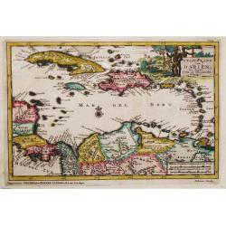
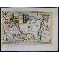
t Vaste Land van Darien ten Zuiden Cuba en Hispaniola Gelegen.
An attractive map showing Colombia, Venezuela and the Caribbean. Embellished with a large and decorative title-cartouche.Pieter van der Aa was a prolific publisher. He pu...
Date: Leiden, 1707
Selling price: ????
Please login to see price!
Sold in 2020
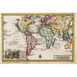
F. Draakx Schip-vaart door de Straat en Zuyd Zee.
An attractive world map in Mercator projection,showing the circumnavigation of Francis Drake. Embellished with a decorative title-cartouche. Pieter van der Aa was a proli...
Date: Leiden, 1707
Selling price: ????
Please login to see price!
Sold in 2019
d'Uytrusting der Engelze Maatshappye onder den Genernal James Lancaster Voor d'Eerst maal over Zee na d' Oost-Indien gedaan.
Detailed map of the region from India to Australia and Japan, illustrating the voyage of James Lancaster in the region.James Lancaster was prominent trader and privateer....
Date: Leiden, 1707
Selling price: ????
Please login to see price!
Sold in 2015
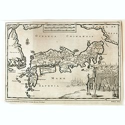
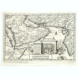
William Adams Reystogt na Oost-Indien.. JAPAN. . .
Map of Japan and Korea. In lower right a fine title cartouche showing William Adams during an audience with the shogun, who sits under a baldachin on a fancifully portray...
Date: Leiden, 1707
Selling price: ????
Please login to see price!
Sold
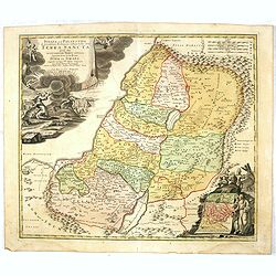
IUDAEA seu PALAESTINA... TERRA SANCTA... IUDA et ISRAEL
Map of Palestine divided among the Tribes, drawn by Homann after Guillaume Sanson. The shoreline runs from Sidon as far as Rinocorura. The Kishon River is shown as connec...
Date: Nuremberg, 1707
Selling price: ????
Please login to see price!
Sold in 2016
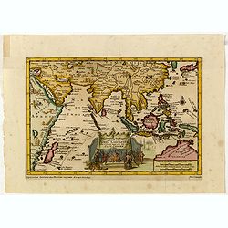
D'Indize Kusten van Bengale, Pegu, Malacca en Siam tot in China, met d'Eylanden Sumatra, Iava, Borneo, Moluccos en andere.
A map of Indonesia extending from the Gulf of Bengal to Taiwan (Formosa) and south to Timor. Including southern China, the Philippines, Sumatra, Borneo, Vietnam and Cambo...
Date: Leiden, 1707
Selling price: ????
Please login to see price!
Sold in 2017
D'Indiaanze Landschappen, Zeen en Eylanden, van Couchin Af, tot in de Moluccos, En na by Gelegen Eylanden, Door Antionio Galvaon Besyevend.
Map of Southeast Asia with India, Malacca, Philippines, Indonesia, Formosa, etc. Lower left a fine title cartouche showing a naval battle and a siege of a town.The map wa...
Date: Leiden? 1707
Selling price: ????
Please login to see price!
Sold in 2016
Jomathan Dickensons Ramspoedige Reystogt van Jamaika na Pensylvania Nagespond
A scarce Van Der Aa map of Florida and the Carolinas unusually oriented to the east and covering the Great Lakes to Jamaica. A very crisp copy in bright example.
Date: Leiden, 1707
Selling price: ????
Please login to see price!
Sold in 2016
De kusten van Arabie het Roode Meer en Persize Zee..
Map of the Arabian Peninsula till West Coast of India, southern Persia and the 'Horn of Africa'.
Date: Leiden, 1707
Selling price: ????
Please login to see price!
Sold in 2016
T Amerikaans Gewest van Florida Door Ferdinand de Soto.
A scarce early 18th century Van Der Aa map of Florida with enormous boundaries covering all of southeastern America from Texas to Lake Erie. A decorative cartouche shows ...
Date: Leiden, 1707
Selling price: ????
Please login to see price!
Sold in 2017
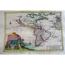
America of Nieuw Ontekte Weereld tot de Beschryving Joseph D'Acosta afgebakend
An interesting 1707 Van Der Aa map of the Western Hemisphere showing one open-ended Great Lake, a misshapen Hudson Bay, California as an island, spurious North American m...
Date: Leiden, 1707
Selling price: ????
Please login to see price!
Sold in 2017
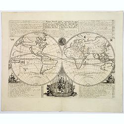
Mappe-Monde pour connoitre les progres & les conquestes...
Unusual double hemisphere map with California as an Island. French text describes the expeditions and colonial possessions of the Dutch East India Company.The map origina...
Date: Amsterdam, ca 1707
Selling price: ????
Please login to see price!
Sold in 2017
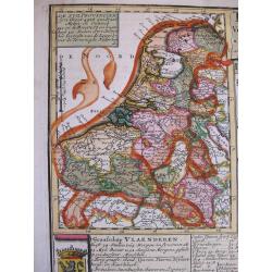
Tabula XVII Foederati Belgii Provinciarum (with Leo Belgicus inset map)
An inset map with a shape of the lion indicated in the sea, shore, and on land.The map is the left part of a folio copper engraving that includes also a distance table, a...
Date: Amsterdam, 1707
Selling price: ????
Please login to see price!
Sold in 2020
D'Indiaanze Landschappen, Zeen en Eylanden, van Couchin Af, tot in de Moluccos, En na by Gelegen Eylanden, Door Antionio Galvaon Besyevend.
Map of Southeast Asia with India, Malacca, Philippines, Indonesia, Formosa, etc. Lower left a fine title cartouche showing a naval battle and a siege of a town.The map wa...
Date: Leiden, 1707
Selling price: ????
Please login to see price!
Sold in 2023
Carte du Piemont et du Montferrat.
Map of Piemont and Montferrat in Italy with the imprint " Chez l’Auteur sur le Quai de l’Horloge (address erased after Horloge). Avec Privilege, Avril 1707. Se t...
Date: Paris, Avril 1707
Selling price: ????
Please login to see price!
Sold in 2018
Amerika of de Nieuwe Weereld.
A fine detailed map centred on the American continent. With charming pictorial title piece on the upper left-hand corner.Although not renowned for the originality of his ...
Date: Leiden 1707
Selling price: ????
Please login to see price!
Sold
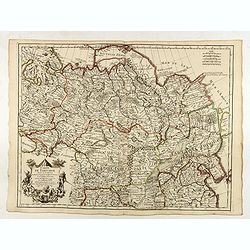
Kaart van Tartaryen.
A fine detailed map of Ukraine, the Crimea and the north-eastern part of the Caspian Sea. With charming pictorial title piece on the lower right-hand corner.Although not ...
Date: Leiden 1707
Selling price: ????
Please login to see price!
Sold