Browse Listings
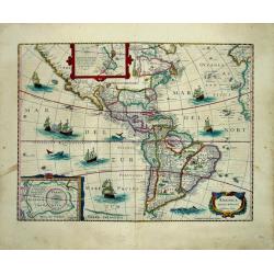
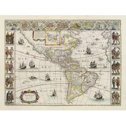
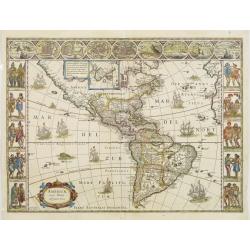
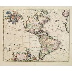
AMERICA / noviter delineata / Auct: Henrico Hondio 1641 / Amstelodami, Excudit Ioannes Ianssonius
A decorative, original color map of North and South America by the famed Hondius publishing house. This map is noted for its elegant engraving and pleasing layout.Th...
Date: Amsterdam, (1618) 1646-1657
Selling price: ????
Please login to see price!
Sold in 2013
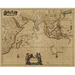
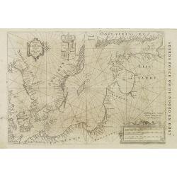
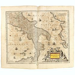
Mar di India.
This from Johannes Janssonius' important sea-atlas 'De Water-Weereld' covers the area between the Cape of Good Hope, Korea and Korea (INS: CORAI) and Japan.It owes its i...
Date: Amsterdam, 1657
Selling price: ????
Please login to see price!
Sold in 2011
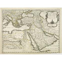
Estats de L'Empire du grand Seigneur des Turqs..
A decorative map of the Mediterranean and countries bordering, extending eastwards to include all the Arabian Peninsula. This edition carries the date 1654.Nicolas Sanson...
Date: Paris, 1654-1657
Selling price: ????
Please login to see price!
Sold in 2013
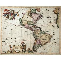
Novissima et accuratissima Totius Americae descriptio..
"""A map of importance...it became the standard representation of North America for a number of years and was copied by other Dutch and English publishers....
Date: Amsterdam 1658
Selling price: ????
Please login to see price!
Sold
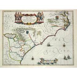
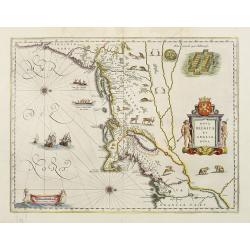
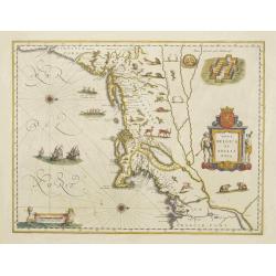
Virginiae partis australis et Floridae paertis orientalis, interjacentiumq3 regionum Nova Descriptio.
Johannes Janssonius, the great rival of Willem Blaeu, was the son-in-law of Jodocus Hondius. Together with Jodocus' son Hendrick, he continued to publish the successive e...
Date: Amsterdam, 1647-1658
Selling price: ????
Please login to see price!
Sold
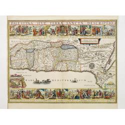
Palestina, Sive Terrae Sanctae Descriptio.
Oriented to the east, divided into the Tribes on both sides of the Jordan, the shoreline from Sidon to Alexandria. Along the top and the bottom 18 vignettes showing the E...
Date: Amsterdam 1658
Selling price: ????
Please login to see price!
Sold
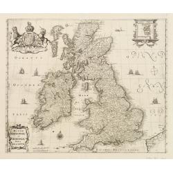
Magnae Britanniae et Hiberniae nova descriptio.
Map shows England, Scotland and Ireland, Shetland islands on separate insert in upper right corner. Belgium coastal area in right bottom. Large uncolored cartouche on top...
Date: Frankfurt, c.1658
Selling price: ????
Please login to see price!
Sold in 2017
![[No title] I. de S.Iuan de Puerto rico?](/uploads/cache/23557-250x250.jpg)
[No title] I. de S.Iuan de Puerto rico?
Interesting chart of the Lesser Antilles, from Porto Rico as far as Trinidad & Tobago and the South American coast. North is orientated to the left of the page. One o...
Date: Amsterdam 1658
Selling price: ????
Please login to see price!
Sold in 2008
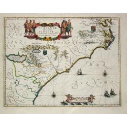
Virginiae partis australis et Floridae paertis orientalis, interjacentiumq regionum Nova Descriptio.
Johannes Janssonius, the great rival of Willem Blaeu, was the son-in-law of Jodocus Hondius. Together with Jodocus' son Hendrick, he continued to publish the successive e...
Date: Amsterdam, 1647-1658
Selling price: ????
Please login to see price!
Sold in 2017
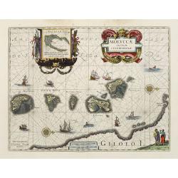
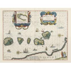
Moluccae Insulae Celeberrimae.
Showing the geographical features of the spice islands, and decorated with ships, sea monsters and a handsome cartouche. In addition to a sumptuous title cartouche, the m...
Date: Amsterdam, 1658
Selling price: ????
Please login to see price!
Sold
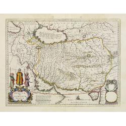
Persia sive Sophorum Regnum.
A finely designed map from the great Blaeu family of Amsterdam. With decorative title cartouche.The cartouches and decoration are colored in an artistic way.The edition w...
Date: Amsterdam, 1658
Selling price: ????
Please login to see price!
Sold in 2012
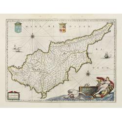
Cyprus Insulae.
Blaeu's beautiful map of Cyprus embellished with a very decorative title cartouche, shows Leda being drawn across the sea by a pair of swans.
Date: Amsterdam, 1658
Selling price: ????
Please login to see price!
Sold
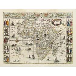
Africae nova descriptio.
Much of the geographical information is still based on the Ptolemaic maps, with the Nile shown with its source in the Lakes Zaire and Zaflan. Also included are various ot...
Date: Amsterdam, 1658
Selling price: ????
Please login to see price!
Sold
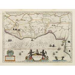
Guinea.
An attractive map covered with intersecting rhumb lines and decorated with monkeys, lions, elephants and native figures. With a dedication to Amsterdam anatomist and phys...
Date: Amsterdam, 1658
Selling price: ????
Please login to see price!
Sold in 2013
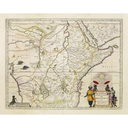
Aethiopia Superior vel Interior vulgo Abissinorum.
An attractive map of the Eastern African and the fictitious kingdom of Prester John. The map shows a major section of central and eastern Africa including Mozambique nort...
Date: Amsterdam, 1658
Selling price: ????
Please login to see price!
Sold in 2010
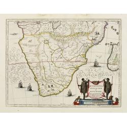
Aethiopia inferior, vel exterior.
The standard map of South Africa throughout the 17th century. The lake out of which the 'Zambere' -the Zambesi- flows is probably based on reports of Lake Ngami, undiscov...
Date: Amsterdam, 1658
Selling price: ????
Please login to see price!
Sold in 2016
Americae Nova Tabula.
The delineation of the coast and the nomenclature on both the Pacific and Atlantic coasts are basically Spanish in origin and follow the maps of Ortelius and Wytfliet. To...
Date: Amsterdam, 1658
Selling price: ????
Please login to see price!
Sold
Nova Belgica et Anglia Nova.
Orientated with north to the right. This is one of the earliest maps to concentrate solely on this area of the colonies, excluding Virginia and the extreme north east coa...
Date: Amsterdam, 1658
Selling price: ????
Please login to see price!
Sold
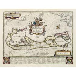
Mappa Aestivarum Insularum alias Barmudas.
Blaeu based his work on John Speed's remarkably accurate map of 1626-1627. It shows the island divided into tribes and lots, and below the map itself appear the names of ...
Date: Amsterdam, 1658
Selling price: ????
Please login to see price!
Sold in 2008
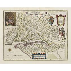
Nova Virginiae Tabula.
The map is based on the first state of Smith's map, 1612, and is slightly larger and more expertly engraved. In 1629 the Hondius plate was purchased by Blaeu who deleted ...
Date: Amsterdam, 1658
Selling price: ????
Please login to see price!
Sold
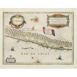
Chili.
Willem Blaeu's very decorative map of Chili with two large and beautiful cartouches, a compass and ships. The modern cities of Santiago (identified on the map as "S ...
Date: Amsterdam, 1658
Selling price: ????
Please login to see price!
Sold in 2012
Moluccae Insulae Celeberrimae.
Showing the geographical features of the spice islands, and decorated with ships, sea monsters and a handsome cartouche. In addition to a sumptuous title cartouche, the m...
Date: Amsterdam, 1658
Selling price: ????
Please login to see price!
Sold
Nova Belgica et Anglia Nova.
Orientated with north to the right. This is one of the earliest maps to concentrate solely on this area of the colonies, excluding Virginia and the extreme north east coa...
Date: Amsterdam, 1658
Selling price: ????
Please login to see price!
Sold
Americae Nova Tabula.
The delineation of the coast and the nomenclature on both the Pacific and Atlantic coasts are basically Spanish in origin and follow the maps of Ortelius and Wytfliet. To...
Date: Amsterdam, 1658
Selling price: ????
Please login to see price!
Sold
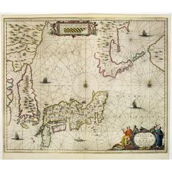
Nova et accurata Japoniae terrae Esonis, ac Insularum. . .
Johannes Janssonius' important map of Japan, notable for its detail of Hokkaido, the first printed map to use the detailed manuscript charts of Maarten de Vries from his ...
Date: Amsterdam, 1658
Selling price: ????
Please login to see price!
Sold in 2011
![[Title page] Nouvelle Methode pour Dresser les Chevaux](/uploads/cache/25521-250x250.jpg)
[Title page] Nouvelle Methode pour Dresser les Chevaux
Copper engraving by Peter Clouwet (1629-1670) after a drawing by Abraham van Diepenbeke. From the famed 17th century work on horsemanship by William Cavendish, Duke of Ne...
Date: Paris, 1658
Selling price: ????
Please login to see price!
Sold in 2011
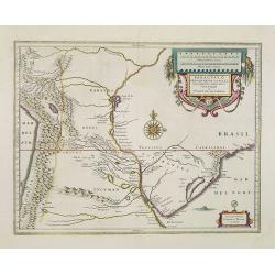
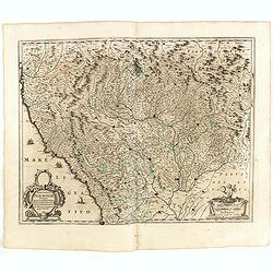
Paraguayo Prov. De Rio De La Plata cum regionibus..
This is an early map showing this northern Patagonia territory. Also showing Rio de Janeiro, Sao Paolo, Santa Cruz of Bolivia, Paraguay, Uruguay, Buenos Ayres, Chili and ...
Date: Amsterdam, 1658
Selling price: ????
Please login to see price!
Sold in 2020
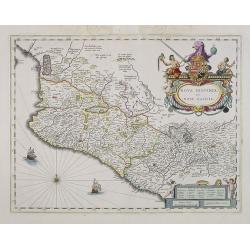
Nova Hispania et Nova Galicia.
Based on Ortelius's map of 1579 which became the basis for many of the seventeenth century maps of the area. Despite the implications in the title, the map does not cover...
Date: Amsterdam, 1658
Selling price: ????
Please login to see price!
Sold in 2013
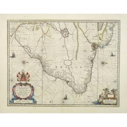
Brasilia.
A mint copy of this map by Krystof Arciszewski, a Polish general who worked for the Dutch West Indian Company. The map perpetuates various myths including the Parime Lago...
Date: Amsterdam, 1658
Selling price: ????
Please login to see price!
Sold in 2009
Americae Nova Tabula.
The delineation of the coast and the nomenclature on both the Pacific and Atlantic coasts are basically Spanish in origin and follow the maps of Ortelius and Wytfliet. To...
Date: Amsterdam, 1658
Selling price: ????
Please login to see price!
Sold in 2015
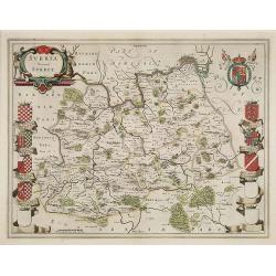
Surria Vernacle Surrey.
Highly decorative showing the seven coats of arms of the Surrey Earls all in full color. Shows towns of London and Kingston on the Thames River, Guildford, Croydon, Richm...
Date: Amsterdam, 1658
Selling price: ????
Please login to see price!
Sold in 2009
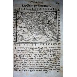
Constantinopolis.
Very rare woodcut birds-eye view of Istanbul/Constantinople. Showing numerous buildings and ships! From Saur's important work "Stätte-Buch... / Beschreibung der f�...
Date: Frankfurt, 1658
Selling price: ????
Please login to see price!
Sold in 2009
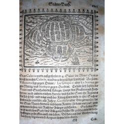
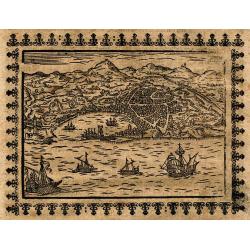
Calaris
Very rare woodcut birds-eye view of Cagliari, the capital of Sardinia. Showing numerous buildings and ships! From Saur's important work "Stätte-Buch... / Beschreib...
Date: Frankfurt, 1658
Selling price: ????
Please login to see price!
Sold in 2009
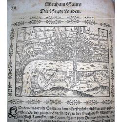
London.
Very rare woodcut birds-eye view of London during the early 17th century. Shows numerous buildings and ships! From Saur's important work "Stätte-Buch.....
Date: Frankfurt, 1658
Selling price: ????
Please login to see price!
Sold in 2009
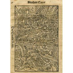
Die Stadt Rom.
Very rare woodcut birds-eye view of Rome during the early 17th century. Shows numerous buildings and streets! On page within text, text also to verso. From Saur's importa...
Date: Frankfurt, 1658
Selling price: ????
Please login to see price!
Sold in 2010
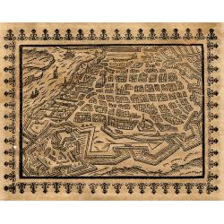
Die Statt Genua.
Very rare German woodcut birds-eye view of Genoa from the early 17th century. Shows the city and the harbour from the sea-side with sailing-ships! On page within decorati...
Date: Frankfurt, 1658
Selling price: ????
Please login to see price!
Sold in 2010
Antorff
Very rare German woodcut birds-eye view of Antwerp during the early 17th century. Shows the city with its buildings and fortifications, and the Scheldt river with ships! ...
Date: Frankfurt, 1658
Selling price: ????
Please login to see price!
Sold in 2010
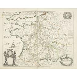
Carte Geograhicque des Postes qui traversent la France. . .
The earliest post road mapspost route map was first published 1632 by Melchior Tavernier - this "Carte Géographique des Postes qui traversent France" shows all...
Date: Paris, 1632-1658
Selling price: ????
Please login to see price!
Sold in 2011
Pascaart vande Oost-Zee beschreven door Willem Ians Blauw ao. 1622.
Very rare chart of the Baltic Sea and the Gulf of Finland. Published in De groote Zee-spiegel. inhoudende een korte Onderswij singe in de konst der zeevaert en eene besch...
Date: Amsterdam, Joan Blaeu, 1655-1658
Selling price: ????
Please login to see price!
Sold in 2010
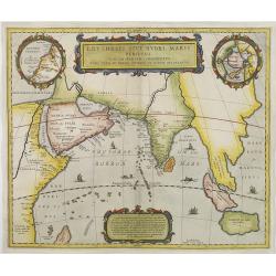
Erythraei sive rubri Maris Periplus. . .
Decorative map covering the north-west coast of Africa, Arabian peninsular, India, Malaysia.Upper right hand corner inset map Hyper Borei , the North Pole after Mercator....
Date: Amsterdam, 1658
Selling price: ????
Please login to see price!
Sold in 2010
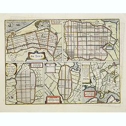
De Zype./ Purmer/ Wormer/ Beemster/ Waterland.
Five maps on one sheet. Showing the polders of De Zype, De Purmer, De Wormer, De Beemster and a map of Waterland, including de Bylmermeer and Monnekedam. Showing the Noor...
Date: Amsterdam, 1652-1658
Selling price: ????
Please login to see price!
Sold in 2011
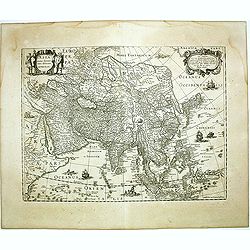
ASIA recens summa cura delineata. Auct. Henr. Hondio.
Henricus Hondius' fine and decorative map of the Continent of Asia depicting a refined Japan and Korea, issued in editions of the Hondius and Janssonius Atlases.French te...
Date: Amsterdam, 1658
Selling price: ????
Please login to see price!
Sold in 2011
Novissima et accuratissima Totius Americae. . .
The second state with privilege along the lower margin. A map of importance. . . it became the standard representation of North America for a number of years and was copi...
Date: Amsterdam, 1658
Selling price: ????
Please login to see price!
Sold in 2013
Nova descriptio totius regni Polonici nec non Magni Ducatus Lithuaniae cum suis Palatinatibus Castellaniis ac Confiniis.
Very rare map of Poland in the shape of an eagle, toped with a crown "Aquila Polonica". The map appeared in the rare work by August Gudicanus "Borussi-Polo...
Date: Cologne, J. A. Kinckium, 1658
Selling price: ????
Please login to see price!
Sold in 2011
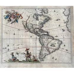
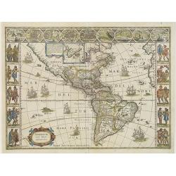
Novissima et Accuratissima Totius Americae Descriptio per N. Visscher.
An extremely decorative, large and famous map of the Western Hemisphere, showing California as an Island and noticeably, at the lower left corner, a small part of New Zea...
Date: Amsterdm, 1658
Selling price: ????
Please login to see price!
Sold in 2020
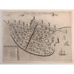
Civitas Acon Sive Ptolomaida.
A very rare plan of Acre, one of the oldest continuously inhabited cities in the world. It shows extensive fortifications, town plan, buildings and a key identifying sign...
Date: Paris, 1658
Selling price: ????
Please login to see price!
Sold in 2023
![[Title page] Topographia Galliae. . .](/uploads/cache/47997-250x250.jpg)
[Title page] Topographia Galliae. . .
Title page from Casper Merian's Topographia Galliae...More about title pages [+]
Date: Frankfurt, 1658
Selling price: ????
Please login to see price!
Sold in 2023
![[Frontispiece] Toonneel des Aerdrycx, oft Nieuwe Atlas.. Tweede stuck.](/uploads/cache/24512-250x250.jpg)
[Frontispiece] Toonneel des Aerdrycx, oft Nieuwe Atlas.. Tweede stuck.
Frontispiece from a Dutch text edition of this fine atlas. The title is attached on a separate piece of paper, as is common, and set in an architectural framework flanked...
Date: Amsterdam, 1658
Selling price: ????
Please login to see price!
Sold in 2022

De Kust van Barbarien. . . / De Reede voor de Stadt Angra. . . / De Eylanden van Madera. . . / De Vlaamsche Eylanden By Jacob Colom. . . /
Rare of the Canaries. Lower right pagination number 35. Unusually large scale chart. Eight charts on one sheet, with on verso Dutch text and two wood cut profiles of Mar...
Date: Amsterdam, 1658
Selling price: ????
Please login to see price!
Sold in 2018
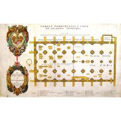
Temple Parochialis s fidis (Faithful of the Parish).
Antique etching published in "History of St. Paul's" by William Dugale in 1658. It was illustrated and etched by the famous Old Master, Wenceslaus Hollar. This...
Date: London, 1658
Selling price: ????
Please login to see price!
Sold in 2013
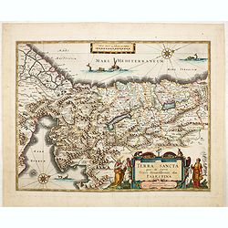
Terra Sancta quae in Sacris Terra Promissionis. . .
Very decorative map of Palestine. Orientated west to the top. The decoration is inspired by the Old Testament. Moses stands to the left of the title cartouche, Aaron to t...
Date: Amsterdam, 1658
Selling price: ????
Please login to see price!
Sold in 2015
![[Title page] Nieuwen ATLAS ofte Weereldt-Beschrijvinghe Eerste Deels Vervolgh ...](/uploads/cache/35603-250x250.jpg)
[Title page] Nieuwen ATLAS ofte Weereldt-Beschrijvinghe Eerste Deels Vervolgh ...
At the top two eagles support six armorial shields.
Date: Amsterdam, 1658
Selling price: ????
Please login to see price!
Sold in 2016
Ager Parisiensis Vulgo L'Isle de France. . .
A very decorative map showing the environs north of Paris with beautiful cartouches.
Date: Amsterdam, 1658
Selling price: ????
Please login to see price!
Sold in 2016
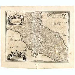
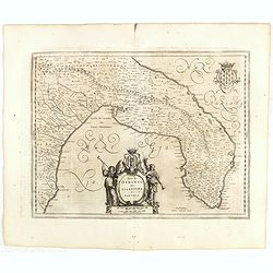
Stato della CHIESA con la Toscana.
Decorative and attractive map of the region from the rare last edition of Janssonius Atlas. Includes sailing ships, sea monster and other decorative embellishments.
Date: Amsterdam, 1645-1658
Selling price: ????
Please login to see price!
Sold in 2015
Stato di Milano.
A most attractive and fascinating map of northern Italy with Milan in center, including Lago Maggiore, Parma, Turin, and Como.
Date: Amsterdam, 1645-1658
Selling price: ????
Please login to see price!
Sold in 2015
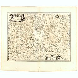
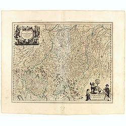
Signoria di Vercelli.
Decorative map centered on Vercelli, including also Novara, etc.
Date: Amsterdam, 1645-1658
Selling price: ????
Please login to see price!
Sold in 2015
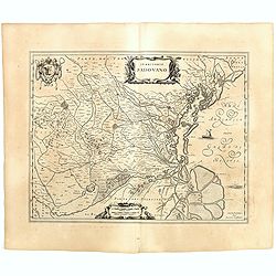
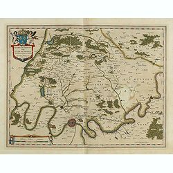
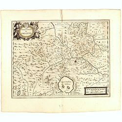
Territorio Podovano.
Map of the Territory of Padua in Northern Italy’s Veneto region. It’s known for the frescoes by Giotto in its Scrovegni Chapel and the vast 13th-century Basilica of S...
Date: Amsterdam, 1645-1658
Selling price: ????
Please login to see price!
Sold in 2015
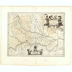
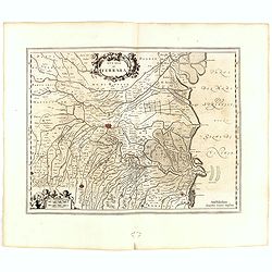
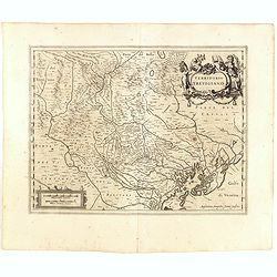
Territorio di Cremona.
Decorative map centered on Cremona and Mantua in the utmost right hand corner.
Date: Amsterdam, 1645-1658
Selling price: ????
Please login to see price!
Sold in 2015
Ducato di Ferrara.
Nice example of Janssonius' map of the Ferrara region, including the towns of Ferrara and Bologna. Includes a decorative cartouche.
Date: Amsterdam, 1645-1658
Selling price: ????
Please login to see price!
Sold in 2015
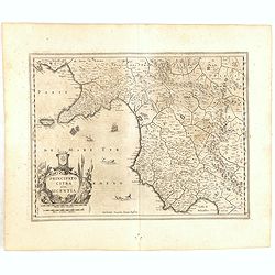
Principato Citra olim Picentia.
Nice example of Janssonius' map of the Mediterranean Coast of Southern Italy, including the Island of Capri and the Gulf of Salerno and the Gulf of Policastro.
Date: Amsterdam, 1645-1658
Selling price: ????
Please login to see price!
Sold in 2015
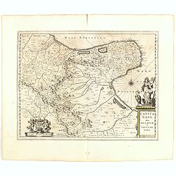
Capitanata olim mesapiae ey iapygiae pars.
Great detail of villages throughout the area, mountains in relief, river systems.
Date: Amsterdam, 1645-1658
Selling price: ????
Please login to see price!
Sold in 2015
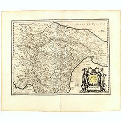
Terra Di Bari et Basilicata .
Janssonius map of the Territory of Bari in Southern Italy. Includes sailing ships, sea monsters and decorative cartouche.
Date: Amsterdam, 1645-1658
Selling price: ????
Please login to see price!
Sold in 2015
Territorio Di Orvieto.
Nice example of Janssonius' map of the Territory of Orvieto in Southern Italy.
Date: Amsterdam, 1645-1658
Selling price: ????
Please login to see price!
Sold in 2015
Contado Di Molise et Principato Ultra.
Decorative regional map of Italy, engraved by Jansson.
Date: Amsterdam, 1645-1658
Selling price: ????
Please login to see price!
Sold in 2015
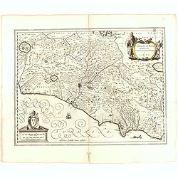
CAMPAGNA DI ROMA olim Latium: Patrimonio Di Pietro et Sabina.
Fine map of the region around Rome that extends from Lago di Bolsena to Gaeta. Rome is depicted in a block plan with its fortifications evident.
Date: Amsterdam, 1645-1658
Selling price: ????
Please login to see price!
Sold in 2015
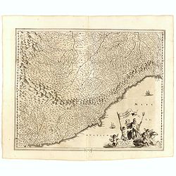
Riviera di Genova Di Ponente.
Nice example of Janssonius' maps of the Italian Riviera, from Nice to Genoa, extending north to Turin. Includes a decorative cartouche and sailing ships.
Date: Amsterdam, 1645-1658
Selling price: ????
Please login to see price!
Sold in 2015
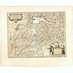
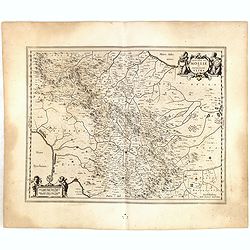
Territorio di VERONA.
The Province of Verona, centered on the city but also showing Mantua and Lake Garda.
Date: Amsterdam, 1645-1658
Selling price: ????
Please login to see price!
Sold in 2015
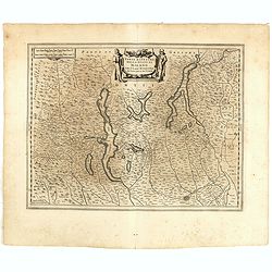
Territorio Trevigiano.
Detailed map of the Gulf of Venice and the area north west of Venice, with Mestre, Padua, Treviso, etc.
Date: Amsterdam, 1645-1658
Selling price: ????
Please login to see price!
Sold in 2015
Parte Alpestre dello Stato di Milano con il Lago Maggiore di Lugano, é di Como.
Detailed map of Milano, with the lakes of Lugano, Maggiore and Como.
Date: Amsterdam, 1645-1658
Selling price: ????
Please login to see price!
Sold in 2015
Neapolitanum Regnum.
Engraved map of the Kingdom of Naples, the 'boot' or southern portion of Italy.
Date: Amsterdam, 1645-1658
Selling price: ????
Please login to see price!
Sold in 2015
Romagna olim Flaminia..
Very fine map centered on the town of Ravenna.
Date: Amsterdam, 1645-1658
Selling price: ????
Please login to see price!
Sold in 2015
Ducato di Modena Regio et Carpi col Dominio della Carfagnana.
Nice example of Janssonius' map of the Emilia Romagna region including Parma, Reggio, Modena, Bologna.
Date: Amsterdam, 1645-1658
Selling price: ????
Please login to see price!
Sold in 2015
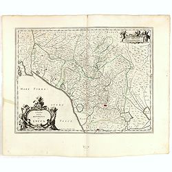
Stato della Republica di Lucca.
Including the area north of the towns of Pisa and Lucca. Two very decorative cartouches.
Date: Amsterdam, 1645-1658
Selling price: ????
Please login to see price!
Sold in 2015
Terra di Otranto olim Salentina et Iapigia.
Map of the Salento Peninsula, Italy.
Date: Amsterdam, 1645-1658
Selling price: ????
Please login to see price!
Sold in 2015
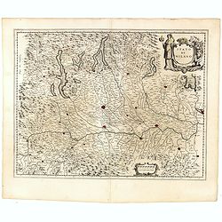
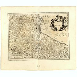
Principatus Pedemontii, Ducatus Augustae Praetoriae, Salutii Marchionatus, Astae, Vercellarum et Niceae Comitatus Nova Tabula
This is a detailed map of the Piedmont region centered on Turin. The Mediterranean coastline is illustrated from Nice to Genoa and the many fortified cities are well docu...
Date: Amsterdam, 1645-1658
Selling price: ????
Please login to see price!
Sold in 2015
![[Title page] from Novus Atlas, Das ist Weltbeschreibung...](/uploads/cache/36449-250x250.jpg)
[Title page] from Novus Atlas, Das ist Weltbeschreibung...
Attractive title page of Janssonius' New Atlas. Very decorative, and finely engraved architectural façade, with figures.The title is printed on a paste-on slip.
Date: Amsterdam, 1658
Selling price: ????
Please login to see price!
Sold in 2015
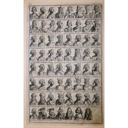
‘Icons of Roman Emperors and Kings of Hungary'
An unusual engraving, comprised of 63 portraits of Roman Emperors and Kings of Hungary. Latin text.From ‘Icons of Roman Emperors and Kings of Hungary’ by Paul Fürst ...
Date: Nuremberg, 1658
Selling price: ????
Please login to see price!
Sold in 2018
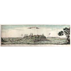
Monmedi en Luxemberg.
A very fine copper engraving featuring the Citadel of Montmedy. In 1221, the first castle of Montmédy was built on top of a hill by the Count of Chiny. Montmédy soon be...
Date: Paris, 1658
Selling price: ????
Please login to see price!
Sold in 2018
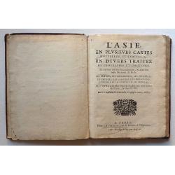
L'Asie en plusievers cartes nouvelles, et exactes, &c
17 copper-engraved double-page maps, outlined in contemp. color. Sheets measure: 27.3 x 36.5 cm. Plate images measure: approx. 20.0 x 26.0 cm., each map varying by a cm. ...
Date: Paris, Chez L'Autheur, rue S. Jacques, 1658
Selling price: ????
Please login to see price!
Sold in 2016

Title page : Topographia Galliae. . .
Title page from Casper Merian's Topographia Galliae...
Date: Frankfurt, 1658
Selling price: ????
Please login to see price!
Sold in 2016