Browse Listings
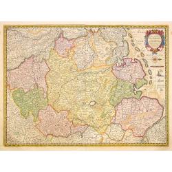
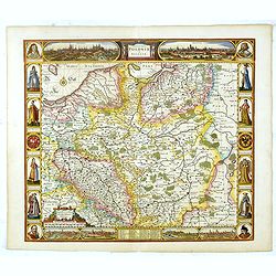
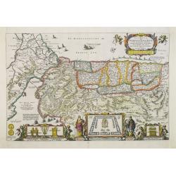
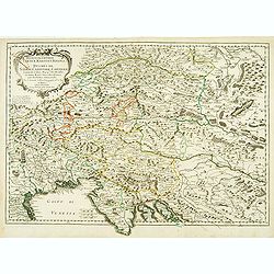
Nova Totius Westphaliae.
Shows the area between Maastricht, Dockum, Herschfelt and Hamburg. A fine copy in attractive colors.
Date: Amsterdam 1656
Selling price: ????
Please login to see price!
Sold
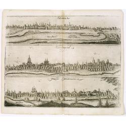
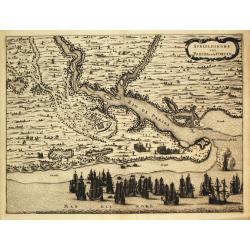
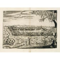
View of Colomna, Cassimogorod and Moru. ma Mordwinorum.
Three early town-views of Colomna, Cassimogorod and Mordwinorum on the Occa river on one sheet.From "Voyages en Moscovie, Tartarie et Perse, par Adam Olearius"....
Date: Paris, Abraham de Wicquefort , 1656
Selling price: ????
Please login to see price!
Sold in 2013
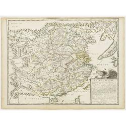
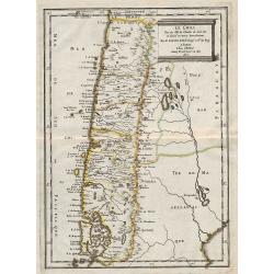
La Chine Royaume. . .
An important and attractive French map of the whole of China, the northern tip of the Philippines, with a strangely curved Korea and an under-sized Taiwan here called &qu...
Date: Paris, 1656
Selling price: ????
Please login to see price!
Sold in 2016
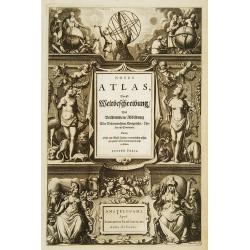
Title page from
Attractive title page of Janssonis's New Atlas. Very decorative, and finely engraved architectural façade, with figures.Engraved by D.v.Bremden.On verso a part of anothe...
Date: Amsterdam, 1656
Selling price: ????
Please login to see price!
Sold
Afbeeldinghe van Pariba ende Forten.
The Dutch fleet before the entrance of the Rio de Paribo. From Isaac Commelin's description of the life and acts of Prince Frederik Hendrik van Nassau (the 'Brasilian').
Date: Amsterdam, 1656
Selling price: ????
Please login to see price!
Sold
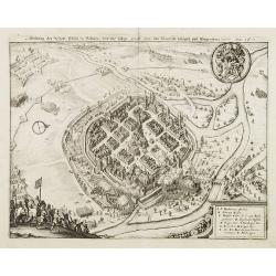
Abbildung der Statt Pilsen in Böhmen und diesselbige durch den:von Mansfeldt belägert und Eingenohmen worden. Anno 1618.
Decorative plan of the town of Pilsen.
Date: Frankfurt, 1656
Selling price: ????
Please login to see price!
Sold in 2008
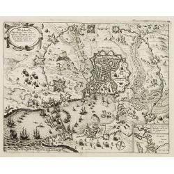
Wahrhaffte Abbildung der Vesten Statt Rochelle, mit Ihren Fortificationen, und dem Königl. Läger und Schantzen Anno 1627. Obsidio Rupellae.
Decorative plan of the siege of 1627 of the town of La Rochelle.
Date: Frankfurt, 1656
Selling price: ????
Please login to see price!
Sold in 2008
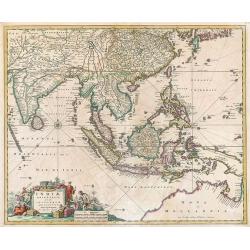
India Orientalis nec non Insularum Adiacentium Nova Descriptio.
This superb map of South East Asia presents a detailed image of the sphere of operations and Asian trading empire of the Dutch East India Company. The map extends from In...
Date: Amsterdam, 1656
Selling price: ????
Please login to see price!
Sold in 2009
Casan Tartacorium.
An early of Kazan, with the Volga river on the left. From "Voyages en Moscovie, Tartarie et Perse, par Adam Olearius".Adam Olearius was a seventeenth-century G...
Date: Paris, Abraham de Wicquefort , 1656
Selling price: ????
Please login to see price!
Sold in 2010
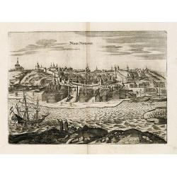
View of Nisen-Navgorod.
An early of Nisen-Navgorod, on the Volga river. From "Voyages en Moscovie, Tartarie et Perse, par Adam Olearius".Adam Olearius was a seventeenth-century German...
Date: Paris, Abraham de Wicquefort , 1656
Selling price: ????
Please login to see price!
Sold in 2013
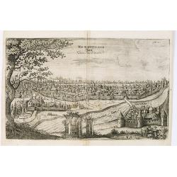
View of Weliki Nowgorod.
An early of Weliki Nowgorod, in the North-West of Russia, on the Volkhov river.From "Voyages en Moscovie, Tartarie et Perse, par Adam Olearius".Adam Olearius w...
Date: Paris, Abraham de Wicquefort , 1656
Selling price: ????
Please login to see price!
Sold in 2012

Combat between John de Astley and Peter de Masse.
Combat between John de Astley & Peter de Masse" which took place in 1438 from 'The Antiquities of Warwickshire' by William Dugdale. 1656.“Of the Patshull bran...
Date: London, 1656
Selling price: ????
Please login to see price!
Sold in 2013
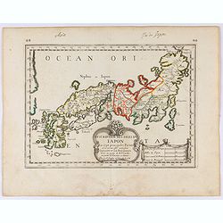
Description des Isles du Iapon. . .
Map of Japan prepared by N.Sanson and published by Pierre Mariette.Published in an early edition of the small Sanson atlas L'Europe Dediée a Monseigneur . . . Le Tellier...
Date: Paris, P. Mariette, 1656
Selling price: ????
Please login to see price!
Sold in 2025
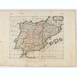
Espagne. . .
Map of Spain and Portugal prepared by N.Sanson and published by Pierre Mariette.Published in an early edition of the small Sanson atlas L'Europe Dediée a Monseigneur . ....
Date: Paris, P. Mariette, 1656
Selling price: ????
Please login to see price!
Sold in 2021
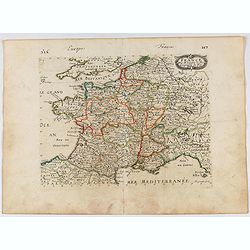
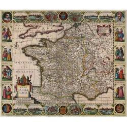
France.
Engraved map of France.
Date: Paris, 1656
Selling price: ????
Please login to see price!
Sold in 2021
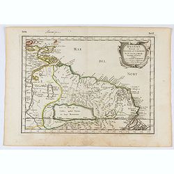
Guiane divisee en Guiane, et Caribane. . .
Map of Guinea prepared by N.Sanson and published by Pierre Mariette. This is a reduced derivative of the famous Sanson map of 1650.Published in an early edition of the sm...
Date: Paris, P. Mariette, 1656
Selling price: ????
Please login to see price!
Sold in 2025
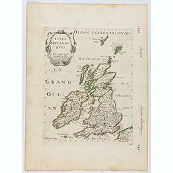
Isles Britanniques . . .
Map of Great Britain prepared by N.Sanson and published by Pierre Mariette. This is a reduced derivative of the famous Sanson map of 1650.Published in an early edition of...
Date: Paris, P. Mariette, 1656
Selling price: ????
Please login to see price!
Sold in 2025
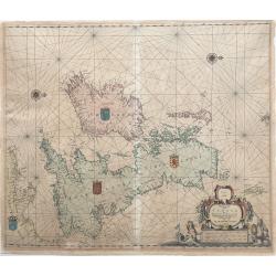
Pascaarte vant Canaal door Arnold Colom t Amsterdam op het Watter by de Nieuwe brugh inde Lichtende Colom.
This large folio, extremely decorative sea chart offered here is one of the earliest and rarest sea charts depicting the British Isles. It appeared in the famous Colom's...
Date: Amsterdam, 1656
Selling price: ????
Please login to see price!
Sold in 2022
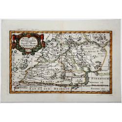
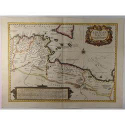
PARTIE DU BILEDULGERID ou sont TESSET, DARHA et SEGELMESSE &c.
A very fine decorative map of Morocco and the Canary Islands. In upper left hand corner decorative title cartouche. Engraved by A.de Winter.
Date: Paris 1657
Selling price: ????
Please login to see price!
Sold in 2019
ISLE DE MADAGASCAR ou de St. LAURENS.
Very fine map of Madagascar, first published by Sanson in 1657. A detailed map of Madagascar and near islands.Sanson notes the source of his map as Livio Sanuto and other...
Date: Paris 1657
Selling price: ????
Please login to see price!
Sold in 2019
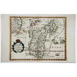
Partie de BARBARIE ou Sont les ROYAUMES de TUNIS et TRIPOLI.
Very decorative map of part of the Mediterranean Coastlines o Tunisia and Libya, first published by Nicholas Sanson in 1657.
Date: Paris, 1657
Selling price: ????
Please login to see price!
Sold in 2019
Mar del Nort.
This lovely sea chart is from the Johannes Janssonius' sea-atlas De Water-Weereld. The decorative title cartouche shows a native American (as interpreted by those in Euro...
Date: Amsterdam, 1657
Selling price: ????
Please login to see price!
Sold in 2020
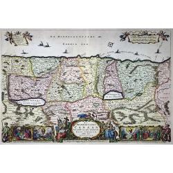
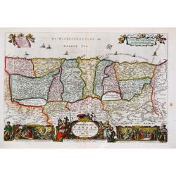
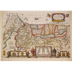
Het Beloofde Landt Canaan door wandelt van onsen Salichmaecker Iesu Christo, neffens syne Apostelen.
Showing the travels of Christ and His disciples. With 36 numbered sites and insets of the Birth, Resurrection, Ascension and Pentecost. Orientated with east to the top.
Date: Amsterdam, 1657
Selling price: ????
Please login to see price!
Sold in 2020
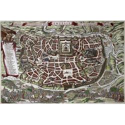
De Heylige en Wytvermaerde stadt Ierusalem Eerst Genaemt Salem, Genesis 14 vers 18
Bird's eye plan of the holy city of Jerusalem with 36 principal sites numbered and keyed to a table in a scroll at left, which is held aloft by an eagle. Biblical scenes ...
Date: Amsterdam, 1657
Selling price: ????
Please login to see price!
Sold in 2020
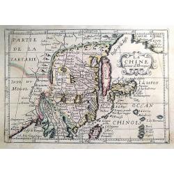
La Chine.
A very uncommon map of China by Picart. With rivers, mountains, lakes and many place names given.
Date: Paris, ca. 1657
Selling price: ????
Please login to see price!
Sold in 2021
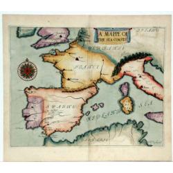
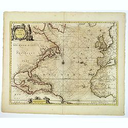
A Mappe of The Sea Coasts. (South-west Europe)
A unusual map showing the Atlantic coasts of Europe and part of the Western Mediterranean, with the northern tip of North Africa. Ungraduated chart. Text in English and L...
Date: England, ca. 1657
Selling price: ????
Please login to see price!
Sold in 2020
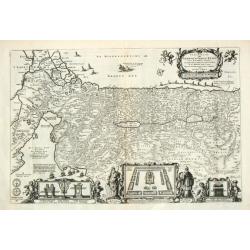
Het Beloofde Landt Canaan door wandelt van onsen Salichmaecker Iesus Christo, neffens syne Apostelen
A decorative map depicting the Holy Land with 4 scenes from the life of Christus, 3 cartouches and two fisherman. Claes Jansz. Visscher (1587-1652). The Dutch so-called '...
Date: Amsterdam, 1657
Selling price: ????
Please login to see price!
Sold in 2021
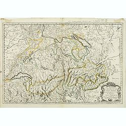
Les Suisses les Allies des Suisses et leurs Suiets. . .
Early imprint of this detailed map of Switzerland. This edition carries the date 1648 and was engraved by R.Cordier Abbauil.Nicolas Sanson was to bring about the rise of ...
Date: Paris, 1648-1657
Selling price: ????
Please login to see price!
Sold in 2013
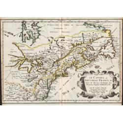
Le Canada, ou Nouvelle France, &c. ...
Map of Canada, from the first edition of the atlas L'Amérique en plusieurs cartes, et en divers traittés de Géographie, et d'Histoire.Nicolas Sanson was to bring about...
Date: Paris, 1657
Selling price: ????
Please login to see price!
Sold in 2012
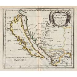
Audience de Guadalajara, Nouveau Mexique, Californie, &c.
Map of California, shown as an island, from the first edition of the atlas L'Amérique en plusieurs cartes, et en divers traittés de Géographie, et d'Histoire.Nicolas S...
Date: Paris, 1657
Selling price: ????
Please login to see price!
Sold in 2012
Le Chili ...
Map of Chile, from the first edition of the atlas L'Amérique en plusieurs cartes, et en divers traittés de Géographie, et d'Histoire.Nicolas Sanson was to bring about ...
Date: Paris, 1657
Selling price: ????
Please login to see price!
Sold in 2012
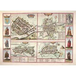
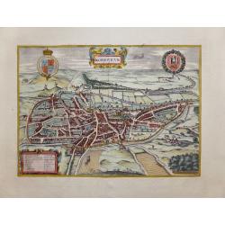
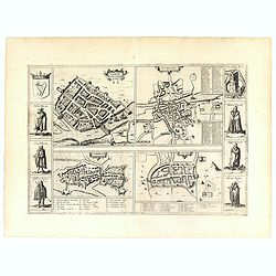
Galwaye, Dubline , Lymericke, and Corcke - Braun & Hogenberg, 1618.
Fine "carte à figures"- map with four Irish bird's-eye plans: Galway, Dublin, Limerick and Cork with left and right borders of costumed figures and top right v...
Date: Amsterdam, (1618) 1657
Selling price: ????
Please login to see price!
Sold in 2013
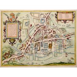
Cantebrigia, Opulentissimi Angliae Regni . . .
A sought after and highly decorative early bird's-eye plan of the ancient university town of Cambridge.The plan originally appeared in Braun & Hogenberg's Civitates O...
Date: Amsterdam, 1657
Selling price: ????
Please login to see price!
Sold in 2013
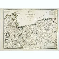
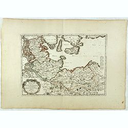
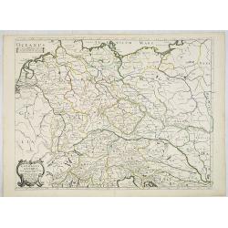
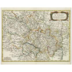
Duché de Pomeranie Contenant les Duchés de Stettin, de Wolgats, de Bardt, de Cassubie, de Vandalie, la Principauté et Isle de Rugen, le Comté de Gutzkow les Seigneuries de Louwenbroch et de Butow. . .
Fine map of Pomerania, now split between Germany and Poland, showing from Rostock east to Gdansk by George-Louis le Rouge.
Date: Paris, 1657
Selling price: ????
Please login to see price!
Sold in 2015
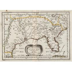
La Floride.
Map of Florida, from the first edition of the atlas L'Amérique en plusieurs cartes, et en divers traittés de Géographie, et d'Histoire.Nicolas Sanson was to bring abou...
Date: Paris, 1657
Selling price: ????
Please login to see price!
Sold in 2013
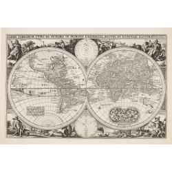
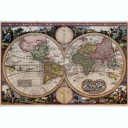
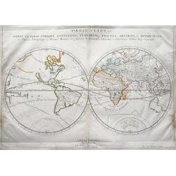
Orbis Terrarum Typus De Integro In Plurimis. . .
Exquisitely decorated double hemisphere world map, surrounded by engravings including allegorical representations of the continents as well as native inhabitants and wild...
Date: Amsterdam, 1657
Selling price: ????
Please login to see price!
Sold in 2014
Nordoviaim.....
The English city of Norwich in the county of Norfolk is shown here from the north-west. The cathedral church "called Christes" is immediately identifiable withi...
Date: Amsterdam, 1657
Selling price: ????
Please login to see price!
Sold in 2014
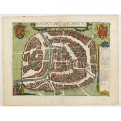
Moscovia urbs Metropolis totius Russiae Albae.
Detailed bird's-eye town-plan of Moscow from Jansson's rare town book. With a key (1-20) to important spots in town. The verso has French text and originates from Jansson...
Date: Amsterdam, 1657
Selling price: ????
Please login to see price!
Sold
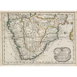
Pays, et Coste des Caffres: Empires du Monomotapa Monoemugi, &c.
Map of South Africa, from the first edition of the atlas L'Afrique en plusieurs cartes nouvelles, et exactes; & en divers traictés de Géographie, et d'Histoire.Nico...
Date: Paris, 1657
Selling price: ????
Please login to see price!
Sold in 2014
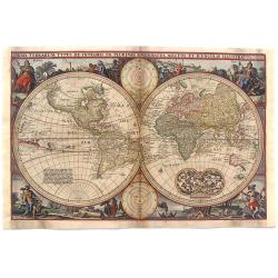
Orbis Terrarum Typus De Integro In Plurimis. . .
Exquisitely decorated double hemisphere world map, surrounded by engravings including allegorical representations of the continents as well as native inhabitants and wild...
Date: Amsterdam, 1657
Selling price: ????
Please login to see price!
Sold in 2017
Orbis Terrarum Typus De Integro In Plurimis Emendatus Auctus et Icunculis Illustratus.
Fine early World Map by Nicolaus Visscher, published in Amsterdam in 1657. This was the "first map" to be inserted in a Dutch bible by Nicholas Visscher and bec...
Date: Amsterdam, 1657
Selling price: ????
Please login to see price!
Sold in 2016
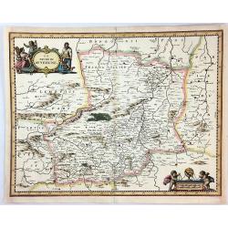
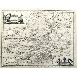
Le Duche de Auvergne.
A quaint map of the Auvergne, printed in Frankfurt by Caspar Merian in 1657. With a decorative title cartouche featuring three peasants from the region. A striking scale ...
Date: Frankfurt, 1657
Selling price: ????
Please login to see price!
Sold in 2016
Galwaye, Dubline , Lymericke, and Corcke.
Four early town plans with six costume vignettes, the Irish crest and a view of Enniskillen Castle down the sides, published in the 'Civitates Orbis Terrarum'. All the il...
Date: Amsterdam, 1657
Selling price: ????
Please login to see price!
Sold in 2019
Tabula nova Poloniae et Silesiae.
Seventh state, with new title and changes in borders. Since a crack was already visible in the view of Gdansk on the 1657 state, Pieter Hendricksz Schut had to etch a new...
Date: Amsterdam, 1630 but after 1657
Selling price: ????
Please login to see price!
Sold in 2016
Basse partie de la Basse Saxe.. Duches de Sleswick, Holsace, Meckelenbourg..
Detailed map of the northeastern part of Germany. Nicolas Sanson was to bring about the rise of French cartography, although the fierce competition of the Dutch would las...
Date: Paris, 1657
Selling price: ????
Please login to see price!
Sold in 2017
Nova Galliae Tabula.
A rare carte à figures of France by Cloppenburg.
Date: Amsterdam, 1657
Selling price: ????
Please login to see price!
Sold in 2017
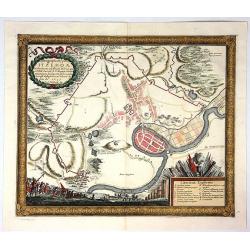
Ichnogeraphia Oppidi Itzehoae.
Itzehoe Germany town plan with course of the Stoer River. The map is copperplate engraved with hand coloring and shows the hinterland of Itzehoe during the Swedish Thirt...
Date: Stockholm , 1657
Selling price: ????
Please login to see price!
Sold in 2017
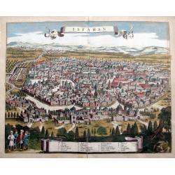
Isfahan.
Jansson's fantastic town-view of Isfahan from his rare 8 volume "Theatrum Urbium", which was the most comprehensive Dutch town-book of the 17th century. The cit...
Date: Amsterdam, 1657
Selling price: ????
Please login to see price!
Sold in 2018
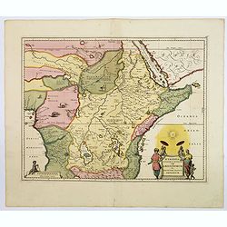
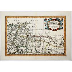
Aethopia Superior vel Inferior vulgo Abissinorum sive.
An attractive map of Eastern Africa and the fictitious kingdom of Prester John. The map shows a large section of central and eastern Africa including Mozambique north to ...
Date: Amsterdam, ca 1657
Selling price: ????
Please login to see price!
Sold in 2018
![[Title page] Theatrum Urbium celebriorum totius Belgii sive Germaniae inferioris pars prior.](/uploads/cache/43263-250x250.jpg)
[Title page] Theatrum Urbium celebriorum totius Belgii sive Germaniae inferioris pars prior.
Rare title page from Janssonius' Town book of the Low Countries and Germany. The town books, published in 1657, containing 500 plates of cities and towns all over the wor...
Date: Amsterdam, 1657
Selling price: ????
Please login to see price!
Sold in 2020
Africae Propriae Tabula. . .
A fine example of Jansson's map of Sicily and North Africa. Decorative map showing the North African coast (Tunisia), Malta and its neighbouring islands, and a part of S...
Date: Amsterdam, 1657
Selling price: ????
Please login to see price!
Sold in 2019
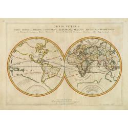
Orbis Vetus, et Orbis Veteris Utraque Continens, Terrarum. . .
Sanson's double-hemisphere world map with ancient place names and latin text. California is shown as an island. A very large suggested Alaska. With parti coastal lines of...
Date: Paris, 1657
Selling price: ????
Please login to see price!
Sold in 2019
Le Duche de Auvergne.
A fine 17th century copper engraved map after Jansson, published in Martin Zeiller's Topographia Galliae. Very detailed, filled with towns, areas, rivers, woods, etc. Wit...
Date: Frankfurt, c1657
Selling price: ????
Please login to see price!
Sold in 2019
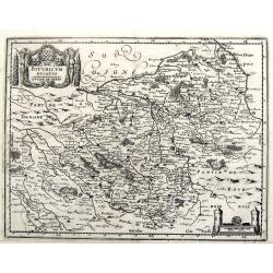
Bituricum Ducatus / Duche de Berri.
A fine copper engraved map published in Martin Zeiller's Topographia Galliae. Very detailed, filled with towns, areas, rivers, woods, etc.
Date: Frankfurt, ca. 1657
Selling price: ????
Please login to see price!
Sold in 2019
![[Title page] Historiae Naturalis de Avibus Libri VI..](/uploads/cache/23372-250x250.jpg)
[Title page] Historiae Naturalis de Avibus Libri VI..
Richly engraved frontispiece, with title at the centre flanked by two winged creatures and surrounded by various specimens of birds.In comparison with the 1650 edition, t...
Date: Amsterdam, 1657
Selling price: ????
Please login to see price!
Sold in 2019
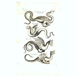
Draco hipes apteros in Agro Bononiensi. . . .
Decorative and early copper engraving showing four dragons, from : Historiae Naturalis de Quadrupedibus libri.The re-edition of the edition of Frankfurt of 1650-53 illust...
Date: Amsterdam, 1657
Selling price: ????
Please login to see price!
Sold in 2020

Utilis Piscis serram ad instar Picis habens. Delphinus prior, Delphin. . .
Decorative and early copper engraving showing a narwhale and four dolphins, from : Historiae Naturalis de Quadrupedibus libri.The re-edition of the edition of Frankfurt o...
Date: Amsterdam, 1657
Selling price: ????
Please login to see price!
Sold in 2020
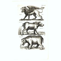
Grijphus, Grijps, Hippopotanus. . .
Decorative and early copper engraving showing a griffin and two sorts of hippopotamus, from : Historiae Naturalis de Quadrupedibus libri.The re-edition of the edition of ...
Date: Amsterdam, 1657
Selling price: ????
Please login to see price!
Sold in 2020
Perigrinatie ofte Veertich-Jarige Reyse der Kinderen..
Finely engraved and detailed. Showing the dispersion of the tribes of Israel. With an inset showing the actual lay out of the camp of the Israelis According to the law of...
Date: Amsterdam, Nic. Visscher, c. 1657
Selling price: ????
Please login to see price!
Sold in 2009
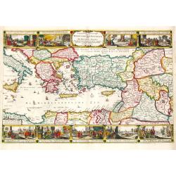
Thessaliae accurata descriptio.
A map of northeast of Greece in classical times by the hand of Johannes Laurenberg appeared in part V of Johannes Janssonius? ?Atlantis Majoris?.Embellished with two deco...
Date: Amsterdam, 1650-1657
Selling price: ????
Please login to see price!
Sold
Hertzogthuber Steyer, Karnten, Krain
Covering southern part of Austria, northern part of the Gulf of Venice and part of former Yugoslavia. Nicolas Sanson was to bring about the rise of French cartography, al...
Date: Paris, 1657
Selling price: ????
Please login to see price!
Sold
Perigrinatie ofte Veertich-jarige Reyse der Kinderen Israels.
Dutch so-called ' Staten' bibles, published between 1637 and c. 1760, contained 5 maps: The World, ' Paradise', The Perigrinations, The Promised Land Canaan, The Travels ...
Date: Amsterdam, Nic. Visscher, c. 1657
Selling price: ????
Please login to see price!
Sold
Peregrinatie ofte Veertich-jarige Reyse der Kinderen Israels.
Claes Jansz. Visscher (1587-1652), founder of the publishing house
Date: Amsterdam, 1657
Selling price: ????
Please login to see price!
Sold
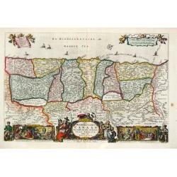
Het Beloofde Landt Canaan door wandelt van onsen Salichmaecker Iesus Christo, neffens syne Apostelen
Claes Jansz. Visscher (1587-1652), founder of the publishing house
Date: Amsterdam, 1657
Selling price: ????
Please login to see price!
Sold
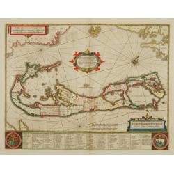
Mappa Aestivarum Insularum, alias Barmudas..
This magnificent map is based on the famous survey by John Norwood of the Bermuda Company in 1618. The map shows the division into the original Tribes and shows the vario...
Date: Amsterdam 1646-1657
Selling price: ????
Please login to see price!
Sold
Geographishe Beschryvinghe van de Wandeling der Apostelen ende de Reysen Pauli . . . door Nicolaes Visscher.
Claes Jansz. Visscher (1587-1652), founder of the publishing house.
Date: Amsterdam, 1657
Selling price: ????
Please login to see price!
Sold
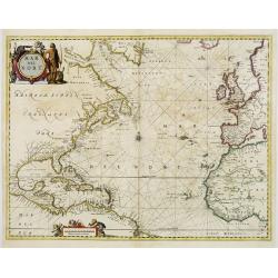
Mar del Nort.
This chart from Johannes Janssonius' sea-atlas 'De Water-Weereld'. The decorative title cartouche shows a native American (as interpreted in Europe!) and various species ...
Date: Amsterdam, 1657
Selling price: ????
Please login to see price!
Sold in 2008
Orbis Vetus, et Orbis Veteris, utraque Continens, Terrarumq Tractus Arcticus, et Antarcticus ex Platone, Theopompo sive Aehano, Manilio. . . Auctore N.Sanson. . .
According to the title Mariette is here presenting Nicolas Sanson's map of the ancient world. The map however includes many 18th century features. Engraved by Jean Somer ...
Date: Paris, Mariette, P., c.1657
Selling price: ????
Please login to see price!
Sold in 2011
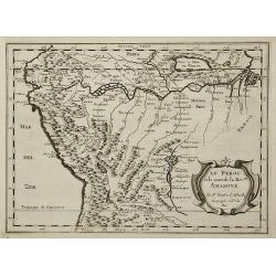
Le Perou et le cours de la Riv.re Amazone ...
Standard map of Peru and the River Amazon prepared by N. Sanson.
Date: Paris, 1657
Selling price: ????
Please login to see price!
Sold in 2011
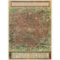
Antiquae Urbis Romae...
Large view of ancient Rome on two joined sheets. Rare. Originally engraved for Braun and Hogenberg, the plates eventually passed to Joannes Janssonius who reissued the pl...
Date: Amsterdam, 1657
Selling price: ????
Please login to see price!
Sold in 2009
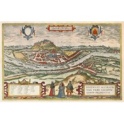
Saltzburgk.
Jansson edition of the Braun & Hogenberg of Salzburg.
Date: Amsterdam, 1657
Selling price: ????
Please login to see price!
Sold in 2009
Germania antiqua. . .
Fine map of ancient Germany, The Netherlands, Belgium, Switzerland, Austria and Poland. The map was first published by Tavernier and later by Mariette. This edition carri...
Date: Paris, 1641-1657
Selling price: ????
Please login to see price!
Sold in 2022
![Mexico, Regia et Celebris Hispaniae Novae Civitas ... [on sheet with] Cusco, Regni Peru in Novo Orbe Caput](/uploads/cache/91340-250x250.jpg)
Mexico, Regia et Celebris Hispaniae Novae Civitas ... [on sheet with] Cusco, Regni Peru in Novo Orbe Caput
Janssonius rare town-plan of Mexico and Cusco. After Braun & Hogenberg. Latin text on verso. From "Theatrum Urbium Celebriorum totius Belgii sive Germaniae Infer...
Date: Amsterdam, 1657
Selling price: ????
Please login to see price!
Sold in 2010
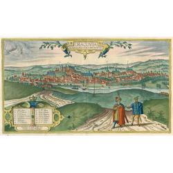
Cracovia Minoris Poloniae Metropolis.
Joannes Janssonius rare town-view of Krakow. After Braun & Hogenberg. Jansson's Theatrum Urbium was the only Dutch atlas to attempt a complete or near complete visual...
Date: Amsterdam, 1657
Selling price: ????
Please login to see price!
Sold in 2010
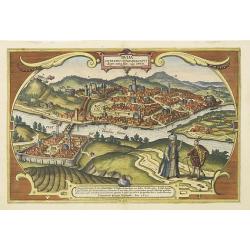
Buda Citerioris Hungariae Caput Regni avita sedes, vulgo Ofen.
Town-plan of the Hungarian capital of Budapest. Originally engraved for the Civitates. Compiled and written by George Braun, Canon of Cologne Cathedral. The drawings was ...
Date: Amsterdam, ca. 1657
Selling price: ????
Please login to see price!
Sold in 2013
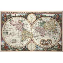
Orbis Terrarum Typus de Integro ..
Exquisitely decorated double hemisphere world map, surrounded by engravings including allegorical representations of the continents and native inhabitants and wildlife. T...
Date: Amsterdam, 1657
Selling price: ????
Please login to see price!
Sold in 2011
Gouvernement General du Lyonnois. . .
Very detailed map of the area Limonges and Lyon in France. Showing also Thiers, Vichy, Bourges, Vallance, Vienne. From M. Merian's famous "Topographia".
Date: Frankfurt, 1657
Selling price: ????
Please login to see price!
Sold in 2011
Lucerna Helvetiorum Vulgo Lucernn.
Very scarce original town view of Lucerne by the Bohemian master Wenceslaus Hollar who worked with Jan Jansson.Highly decorative: The view is presented with 95 (!) number...
Date: Amsterdam, 1657
Selling price: ????
Please login to see price!
Sold in 2011
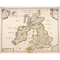
Carte generale des Royaume d'Angleterre Escosse et Irlande..
Fine map of the British Isles, in a second state. The map was first published by Tavernier and later by Mariette. This edition carries the date 1640, and address of Pierr...
Date: Paris, 1640-1657
Selling price: ????
Please login to see price!
Sold in 2011
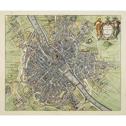
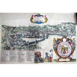
Lutetia Parisiorum Vulgo PARIS.
First state of this fine town-plan of Paris published in Joannes Janssonius Town book "Theatrum exhibens celebriores Galliae et Helvetiae urbes". This plan deri...
Date: Amsterdam, c.1657
Selling price: ????
Please login to see price!
Sold