Browse Listings
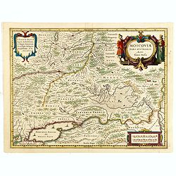
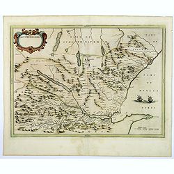
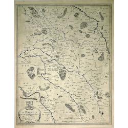
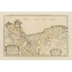
Moscoviae pars australis...
Fine example of this early map of the southern part of Russia, showing the region centered on Moscow. Prepared by Isaac Massa, a Dutch map-maker who travelled to Russia, ...
Date: Amsterdam, ca. 1654
Selling price: ????
Please login to see price!
Sold in 2015
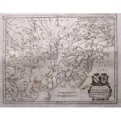
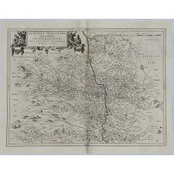
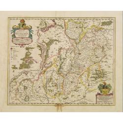
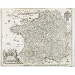
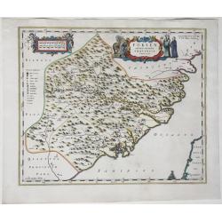
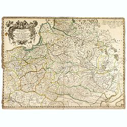
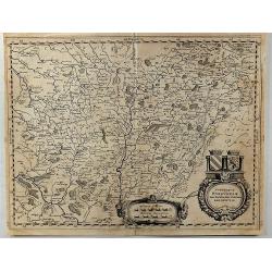
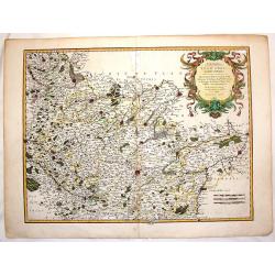
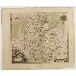
Wine Region Burgundy - Utriusque Burgundiae tum Ducatus tum Comitatus descriptio.
Decorative map of the Wine Region Burgundy. Large cartouche with coats of arms and pictorial scale of miles.
Date: Frankfurt am Main, 1654
Selling price: ????
Please login to see price!
Sold in 2015
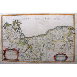
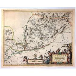
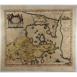
HERTZOGTHUMB POMMERN DUCHE DE POMERANIE divise en ses Princip les Parties qui sont les Princip te de Rugue, Duche de Stettin, Pomeranie, Cassubie, et Wandalie ...
Very fine map of the northern part of Poland. Nice details of forests, villages and rivers. Two nice full color cartouches.Nicolas Sanson was to bring about the rise of F...
Date: Paris, 1654
Selling price: ????
Please login to see price!
Sold in 2015
Anciens Royaumes de Mercie et East Angles. . .
Ancient Kingdoms of Mercia and East Anglia. This is a striking map showing the ancient Saxon kingdoms of Mercia and East Anglia including the counties and shires of Chest...
Date: Paris, 1654
Selling price: ????
Please login to see price!
Sold in 2017
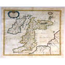
Insulae Albion et Hibernia Cum Minoribus Adjacentibus.
This map of the British Isles during ancient times is based on the cartography of Mercator. The map delineates and names ancient regions via hand coloring and engraved li...
Date: Amsterdam, 1654
Selling price: ????
Please login to see price!
Sold in 2016
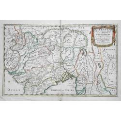
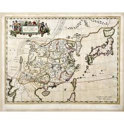
L'Inde decà et dela le Gange, ou est L'Empire du Grand Mogol.
An excellent mid 17th century map showing the area from Afghanistan and Pakistan in the west, and western China on the east, with most of India and extending north to the...
Date: Paris, 1654
Selling price: ????
Please login to see price!
Sold in 2017
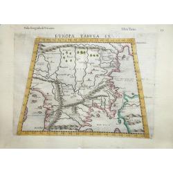
Europae Tabula IX .
A fine Ptolemaic map that covers the Balkans and includes the Bosphorus one of the earliest maps of Turkey and Macedonia. The map, drawn on a trapezoidal projection, is b...
Date: Venice, 1654
Selling price: ????
Please login to see price!
Sold in 2016
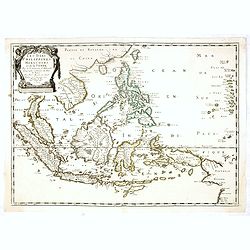
Les Isles Philippines Molucques et de la Sonde.
Sanson's important mid-seventeenth century map of the East Indies, covering modern Indonesia, the Philippines, Malaysia and parts of Southeast Asia and New Guinea. At a s...
Date: Paris, 1654
Selling price: ????
Please login to see price!
Sold in 2017
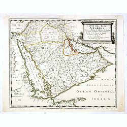
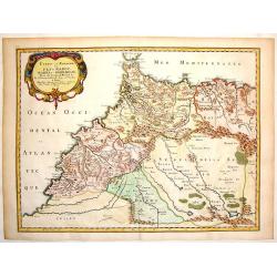
Carte des Trois Arabies. Tiree en Partie de l'Arabe de Nubie, en Partie de Divers autres Autheurs. . .
Rare map of the Arabian Peninsula, first published in 1654 and one of the first large maps focused specifically on the Arabian Peninsula. Sanson's map of the Arabian Peni...
Date: Paris, 1654
Selling price: ????
Please login to see price!
Sold in 2016

Pascaerte van Guinea, en Angola, van R de Gambia tot Cabo de Bona Esperanca.
A sea chart of the Gulf of Guinea, with the neighbouring countries, it shows the coasts and all places. In the sea some boats for decoration and the islands of Fernando, ...
Date: Amsterdam, 1654
Selling price: ????
Please login to see price!
Sold in 2017
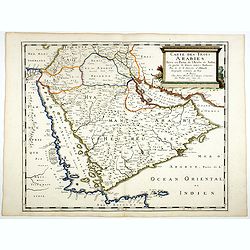
Carte des Trois Arabies. Tiree en Partie de l'Arabe de Nubie, en Partie de Divers autres Autheurs. . .
Rare map of the Arabian Peninsula, first published in 1654 and one of the first large maps focused specifically on the Arabian Peninsula. Sanson's map of the Arabian Peni...
Date: Paris, 1654
Selling price: ????
Please login to see price!
Sold
Southerlandia.
A map from the first comprehensive atlas of Scotland, published by Blaeu in 1654, after an earlier work of the region by Gordon. 'Southerlandia' is a highland region of n...
Date: Amsterdam, 1654
Selling price: ????
Please login to see price!
Sold in 2018
Glottiana Praefectura Inferior cum Baronia Glascuensi.
A fine map of the Glasgow region of Scotland. It extends from Glasgow to Lanark with Hamilton at its centre, and Kyle to Lothian. The map was drawn by Timothy Pont and su...
Date: Amsterdam, 1654
Selling price: ????
Please login to see price!
Sold in 2018
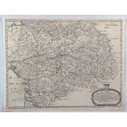
Le Barrois.
A detailed map centred on Bar-le-Duc in the province of Le Barrois. It features a decorative title cartouche with a coat of arms at the lower left. It was engraved by Je...
Date: Paris, 1654
Selling price: ????
Please login to see price!
Sold in 2019
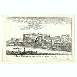
Veuë et Perspective d'une partie des Ville et Chasteau d'Avignon.
Eye-bird view of castle at Avignon and part of the town. Etching by Israel Silvestre called the Younger to distinguish him from his father, was a prolific French draftsma...
Date: Paris, 1654
Selling price: ????
Please login to see price!
Sold in 2020
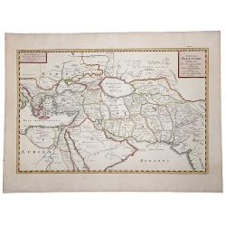
EXPEDITIONS ALEXANDRI MAGNI Per Europam, Assiam et Africam, Tabula Geographica.
A detailed outlined hand-colored map of the region bounded by the Eastern Mediterranean in the West and India in the east, centered on the Arabian Peninsula, Persia and I...
Date: Paris, 1654
Selling price: ????
Please login to see price!
Sold in 2019
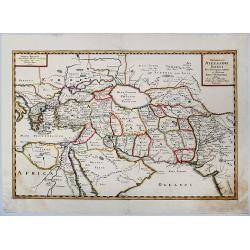
Expeditionis ALEXANDRI MAGNI Per Europa, Asiam et Africam.
Detailed, colored map of the region bounded by the Eastern Mediterranean in the West and India in the east, centered on the Arabian Peninsula, Persia and Iraq.
Date: 1654
Selling price: ????
Please login to see price!
Sold in 2019
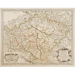
Konigreich Boheim. Royaume de Boheme..
Covering Czech Republic and centered on Prague. Nicolas Sanson was to bring about the rise of French cartography, although the fierce competition of the Dutch would last ...
Date: Paris 1654
Selling price: ????
Please login to see price!
Sold in 2010
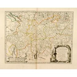
Le Tirol.. Bregentz/ Feldkirck.. Trente/ Brixen.
Fine map of Tyrol.This edition carries the date 1654.Nicolas Sanson was to bring about the rise of French cartography, although the fierce competition of the Dutch would ...
Date: Paris 1654
Selling price: ????
Please login to see price!
Sold
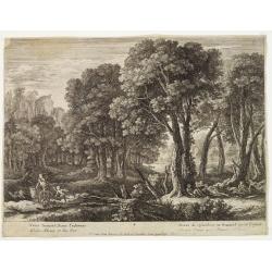
The adventures of Diana with Endormye, and Venus with Adonis.
v.Swanevelt drew, sculped and edited the engraving.
Date: The Netherlands 1654
Selling price: ????
Please login to see price!
Sold
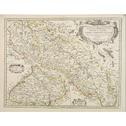
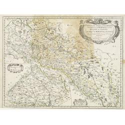
Provinces Unies, et Incorporees a la Couronne de Boheme, qui sont les Duche de Silesie, Marq sats de Moravie, et Lusace.
Two maps on one sheet. A fine map of East Poland & Lithuania. With Breslaw in the center.Nicolas Sanson was to bring about the rise of French cartography, although th...
Date: Paris 1654
Selling price: ????
Please login to see price!
Sold
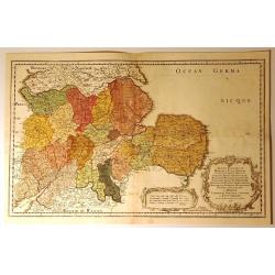
Duche de Pomeranie..
Fine map of the northern part of Poland.This edition carries the date 1654. Nicolas Sanson was to bring about the rise of French cartography, although the fierce competit...
Date: Paris 1654
Selling price: ????
Please login to see price!
Sold
Lidelia Vel Lidisdalia Regio, Lidisdail.
A map of Liddesdale, a historic district of Scotland, bordering Teviotdale to the east, Annandale to the west, and Tweeddale to the north, with the English county of Cumb...
Date: Amsterdam, 1654
Selling price: ????
Please login to see price!
Sold in 2016
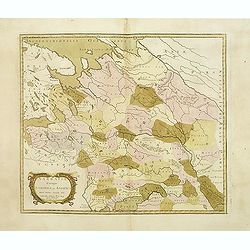
Provinces unies et . . . De Silesie . . . / Marquisat de Moravie.
Two maps on one sheet. Covering Poland, the main map centered on the river Odwer with Wroclaw. In lower left corner inset map of Slovakia.This edition carries the date 16...
Date: Paris, 1654
Selling price: ????
Please login to see price!
Sold
Sarmatia Utraque Europaea et Asiatica..
The ancient map of the European part of Russia. Nicolas Sanson was to bring about the rise of French cartography, although the fierce competition of the Dutch would last ...
Date: Paris, 1654
Selling price: ????
Please login to see price!
Sold in 2011
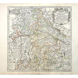
Bayern Baviere..
"Covering southern part of Germany, centered on Regensburg, Augsburg, Munich, etc. Engraved by R.Cordier Abbauil. Nicolas Sanson was to bring about the rise of Frenc...
Date: Paris 1655
Selling price: ????
Please login to see price!
Sold
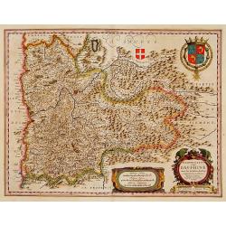
Delphinatus vulgo DAUPHINÉ...Par Jean de Beins.
Beautiful map of a province of France by the most famous map publisher. Centered on Grenoble. Also showing Lyon, Chambéry, Briançon, Vienne, Valence, etc. In the lower ...
Date: Amsterdam 1644-1655
Selling price: ????
Please login to see price!
Sold
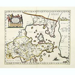
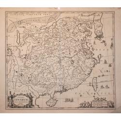
Xantung, sinarum imperii provincia quarta.
Map of the province of Shandong.From the Blaeu\'s \"Novus Atlas Sinensis\". Ornated with the typical high decorative ornated title cartouche together with an mi...
Date: Amsterdam, 1655
Selling price: ????
Please login to see price!
Sold in 2008
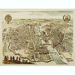
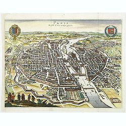
Paris Wie Solche A.° 1620. im Weffen geftanden.
Bird's eye view of Paris presenting the town's coat of arms on the upper left corner and the coat of arms of France on the upper right corner.
Date: Francfort-sur-le-main, 1655
Selling price: ????
Please login to see price!
Sold
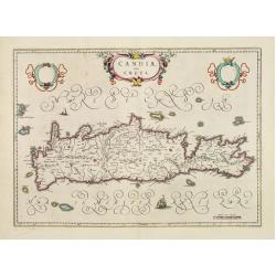
Candia, olim Creta.
One of the most beautiful ever produced maps of Crete.
Date: Amsterdam 1655
Selling price: ????
Please login to see price!
Sold
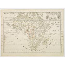
Afrique..
Fine map of Africa including the twin lake sources of the Nile and a peculiar mountain ranges.The format includes the Canary and Cape Verde Islands as well as several oth...
Date: Paris c.1655
Selling price: ????
Please login to see price!
Sold
Partie de la Coste de Barbarie en Africque..
Decorative map of northern part of Africa with Tunisia and Libya, including Malta.Engraved by Joannes Somer. A first state with address A Paris chez Pierre Mariette en la...
Date: Paris 1655
Selling price: ????
Please login to see price!
Sold
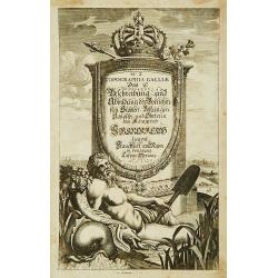
Title page : Topographia Galliae....
Title page from Merian's Topographia Galliae...
Date: Frankfurt 1655
Selling price: ????
Please login to see price!
Sold
Ducatus Silesiae Glogani Vera Delineatio..
Centered on Glogàw. Decorative map prepared by Jonas Scultetus, a Silesian cartographer (1603-1664).
Date: Amsterdam, 1655
Selling price: ????
Please login to see price!
Sold in 2017

Title page : Novus Atlas Sinensis..
Title page of this cartographic landmark: the first European atlas of China, that's why the cute little cherubs are holding a map of East Asia and the globe's face also s...
Date: Amsterdam 1655
Selling price: ????
Please login to see price!
Sold
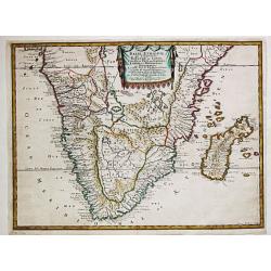
Aethiopie, qui Compren les Royaume de Congo, Coste et Pays des Cafres, Empires du Monomotapa et Monoemugi...Par N. Sanson... A Paris Chez P. Marieete...1655. I Somer Pruthenis sculp.
Nicolas Sanson (1600-67), 'father of the French cartography' and founder of the Sanson firm. Atlas ' Cartes générales de toutes les parties du Monde', 1658-70 and a poc...
Date: Paris, P. Mariette, 1655
Selling price: ????
Please login to see price!
Sold in 2017
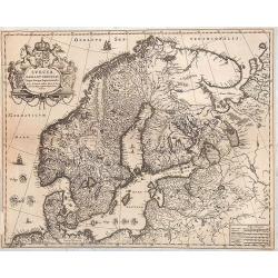
Suecia, Dania et Norvegia, Regna Europae Septentrionalia.
Decorative map of Scandinavia.
Date: Amsterdam, 1655
Selling price: ????
Please login to see price!
Sold in 2014
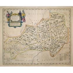
Quangsi, Sinarum Imperii Provinciae Decimatertia.
A map of a part of China published by J. Blaeu, in the second landmark in the European mapping of China "the Atlas Sinensis" in 1655.
Date: Amsterdam, 1655
Selling price: ????
Please login to see price!
Sold in 2009
Galliae Nouael accurata descriptio Vulgo Royaume de France. . .
A map of France.From Merian's Topographia Galliae. . . . In lower left corner fine title cartouche, and upper right coat of arms of France.
Date: Frankfurt, 1655
Selling price: ????
Please login to see price!
Sold
Imperii Sinarum.
A very decorative map of China. In the ocean, six vessels are depicted. Title cartouche on the lower left hand corner.Joannes van Loon was an accomplished mathematician a...
Date: Amsterdam, 1655
Selling price: ????
Please login to see price!
Sold in 2009
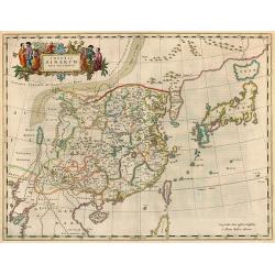
Imperii Sinarum Nova Descriptio
A important general map of China, Korea and Japan, published by Joan Blaeu in the Jesuit Martino Martini's Atlas Sinensis , the first western atlas of China. Incorporates...
Date: Amsterdam, 1655
Selling price: ????
Please login to see price!
Sold in 2010
Gouvernement General de L'Isle de France et Pais Circomvoisins.
Map of regions in France by Casper Merian from his Topographia Galliae. Overall a wonderfully detailed composition which features major cities such as Paris, Chartres, an...
Date: Frankfurt, 1655
Selling price: ????
Please login to see price!
Sold in 2010
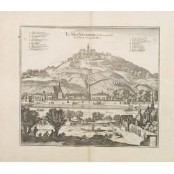
Le Mont Valerien. Autrement dit-Le Calvaire. 2 lieus de Paris.
A view of the Mount Valerien in the Paris vicinities. Very well engraved with excellent detail. Plan for the Mont Valérien Calvary near Paris. As early as the 15th centu...
Date: Frankfurt, 1655
Selling price: ????
Please login to see price!
Sold in 2013
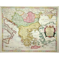
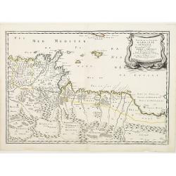
Estats de L´Empire des Turqs en Europe et Pays circomvoisins....
Map of Greece with all islands, partly showing Italy and Turkey.
Date: Paris, 1655
Selling price: ????
Please login to see price!
Sold in 2014
Paris Wie Solche A.° 1620. im Weffen geftanden.
Decorative and important town-plan of Paris with coats of arms of the city.
Date: Frankfort, 1655
Selling price: ????
Please login to see price!
Sold
Estats et Royaumes de Fez et Maroc, Darha et Seglmesse.
A decorative map of Morocco with illustrated topography and many towns and villages. Beautifully engraved title cartouche. Extends into Algeria with good detail of rivers...
Date: Paris, 1655
Selling price: ????
Please login to see price!
Sold in 2019
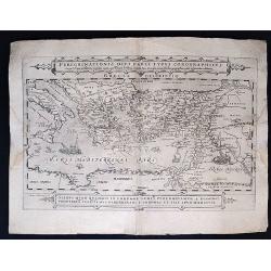
Peregrinationis Divi Pauli Typus Corographicus. . .
Peregrinationis Divi Pauli Typus Corographicus In quo & novi testamenti, in primis autem apostulorum historiae, a Sancto Luca descripta, omnia fere loca geographica, ...
Date: Paris, 1655
Selling price: ????
Please login to see price!
Sold in 2020
Fokien, Imperii Sinarum Provincia Undecima.
A map of the Chinese province of Fokien, by Joan Blaeu. Title in a cartouche with Chinese figures at top centre. At top left a cartouche with putti containing mileage sca...
Date: Amsterdam, 1655
Selling price: ????
Please login to see price!
Sold in 2020
Gouvernement General D'Orleans.
A nice regional map of France showing the area around Tours and Orleans. From M. Merian's "Topographiae Galliae".Matthäus Merian the Elder (1593-1650) studied ...
Date: Frankfort, 1655
Selling price: ????
Please login to see price!
Sold in 2020
Nova Delineatio PERSIAE et Confiniorum Veteri longe accuratior edita Anno 1655.
The first realistic map of Iran. Highly important regional map of the Persian Empire, published by Adam Olearius in 1656, in his Vermehrte newe Beschreibung der muscowiti...
Date: Schleswig or Hamburg, 1655
Selling price: ????
Please login to see price!
Sold in 2020
![[ Lot of 3 maps] Terra Firma et Novum Regnum.](/uploads/cache/19390-(1)-250x250.jpg)
[ Lot of 3 maps] Terra Firma et Novum Regnum.
Willem Blaeu’s map of Columbia with the Isthmus of Panama. Embellished with two cartouches and two compass-roses. Willem Blaeu, the father of Johan and Cornelis Blaeu, ...
Date: Amsterdam, 1655
Selling price: ????
Please login to see price!
Sold in 2022
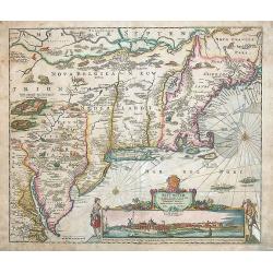
Novi Belgii novaeque Angliae nec non partis Virginiae tabula multis in locis emendata a Iusto Dackers.
This map belongs to the most famous maps of New England. It shows the East coast from the Chesapeake to the St. Lawrence river. The map was firstly published by J. Dancke...
Date: Amsterdam, 1655
Selling price: ????
Please login to see price!
Sold in 2014
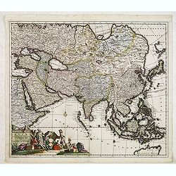
Exactissima Asiae Delineatio..
With a very decorative title cartouche lower left featuring camels, cockatoos and Eastern merchants bartering their wares.
Date: Amsterdam, 1655
Selling price: ????
Please login to see price!
Sold in 2013
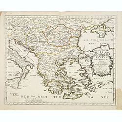
Estats de L'Empire des Turqs en Europe et pays circomvoisins.
Fine map of Greece, including lower part of Italy, western part of Turkey and the Black Sea with Crimea.This edition carries the date 1655.Nicolas Sanson was to bring abo...
Date: Paris, 1655
Selling price: ????
Please login to see price!
Sold in 2013
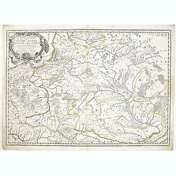
Germano-Sarmatia in qua Populi maiores Venedi et Aetiaei Peucini et Bastarnae in minores Populos divisi ad hodiernam locorum et Regionum
Fine map of ancient Poland and the whole of Eastern Europe, showing part of the Baltic and Gulf of Riga, including the modern countries of Poland, Lithuania, Ukraine and ...
Date: Paris, 1655
Selling price: ????
Please login to see price!
Sold in 2013
Estats et Royaumes de Fez et Maroc, Darha et Segelmesse.
A striking map of today's Morocco and Algeria that includes the southern tip of Spain and the Strait of Gibraltar. Decorated by a large title cartouche.Nicolas Sanson (16...
Date: Paris, 1655
Selling price: ????
Please login to see price!
Sold in 2014
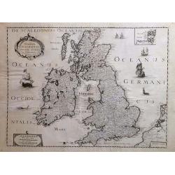
Novissima descriptio Angliae Scotiae et Hiberniae.
A striking and highly detailed copper engraved map of British Islands, including United Kingdom, Ireland and portions of Netherlands. The map gives several details concer...
Date: Paris, 1655
Selling price: ????
Please login to see price!
Sold in 2018

Xensi Imperii Sinarum provincia tertia.
Based on the remarkably accurate compilations of the Jesuit Father Martino Martini during his travels between 1643 and 1650, this map of the Xensi (Shaanxi) province feat...
Date: Amsterdam, 1655
Selling price: ????
Please login to see price!
Sold in 2015
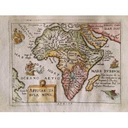
Africae Tabula Nova.
From Italian pirated edition of Ortelius miniature atlas 'Theatro del Mondo di Abraamo Ortelio' by Giovanni Turrini in 1655. Italian text on verso. Page size about 135 by...
Date: Venice, G. Turrini, 1655
Selling price: ????
Please login to see price!
Sold in 2015
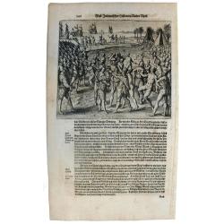
Sir Francis Drake crowned King of California.
Rare 1655 view of Sir Francis Drake, English soldiers paraded and planting the flag while native Californians celebrate and place a crown on Drake's head. From "Newe...
Date: Frankfurt, 1655
Selling price: ????
Please login to see price!
Sold in 2015
Diocese, Prevoste, et Eslection de Paris le Diocese Divise en Archipbreis .....
Fine copper engraved map of the Island of Paris. Adorned by a striking strap title cartouche.By Matthaus Merian, considered to be the grandmaster of the city view. He inh...
Date: Frankfurt, 1655
Selling price: ????
Please login to see price!
Sold in 2017
Estats De La Couronne De Pologne ou sont les Royaume de Pologne, Duches et Provinces De Prusse, Cuiave, Mazovie, Russie Noire &c.
First state of Sanson's map of modern day Poland, Lithuania, Belarus and Ukraine. Dated 1655 and revised several times over the next 50 years. Engraved by J.Sommer.Nicola...
Date: Paris, 1655
Selling price: ????
Please login to see price!
Sold in 2016
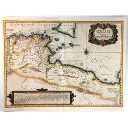
Africae Propriae Tabula. In Qua, Punica Regna Vides, Tyrios, et Agenoris Urbem
A fine decorative map of the coasts of present day Tunisia and Libya, with southern Sicily and Malta. It has a fancy title cartouche, a detailed compass rose, and a large...
Date: Amsterdam, ca.1655
Selling price: ????
Please login to see price!
Sold in 2016
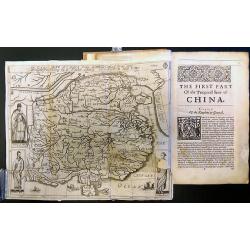
The History of That Great and Renowned Monarchy of China.
An important account of China, written by the Portuguese Jesuit Alvarez de Semedo (1586-1658), who was stationed in China from 1613 to 1637. On his return to Europe, Seme...
Date: London, 1655
Selling price: ????
Please login to see price!
Sold in 2017
Imperii Sinarum Nova Descriptio.
A superb map of the Chinese Empire based on the compilation of the Jesuit Father Martino Martini who travelled through the region between 1643 and 1650.This was a period ...
Date: Amsterdam, 1655
Selling price: ????
Please login to see price!
Sold in 2017
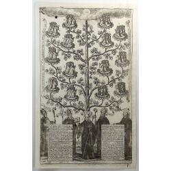
Order of St. Benedict (The Benedictine Tree).
A fine religious print featuring St. Benedict by Wenseslaus Hollar (signed by him in print). Published in 1655. It features a tree with St. Benedict with a crozier in his...
Date: London, 1655
Selling price: ????
Please login to see price!
Sold in 2018
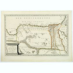
Royaume et Desert de Barca et L'Egypte. . .
A striking map of Egypt and the eastern parts of Libya by Nicholas Sanson, "the founder of French cartography" (Tooley). The map extent is from Sidon in the Hol...
Date: Paris, 1655
Selling price: ????
Please login to see price!
Sold in 2018
Xantung Sinarum Imperii Provincia Quarta.
A map of the province of Shandong, China. Many larger cities are named including Tungchang, Cinan, Yencheu. Laicheu and Leaochang. At the upper right side is an engrave...
Date: Amsterdam, 1655
Selling price: ????
Please login to see price!
Sold in 2018
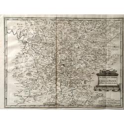
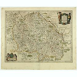
Urivsque Burgundiae tum Ducatus tum Comitatus Descriptio.
Fine copper engraved map by Matthäus Merian from “Neuwe Archontologia Cosmica” Published in Frankfurt in 1646. The map shows the French region of Burgundy with the...
Date: Frankfurt, 1655
Selling price: ????
Please login to see price!
Sold in 2018
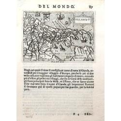
Ollandt.
A fine miniature map of Holland, including a sea-monster and several sailing ships. The map was published by Pietro Marchetti in his Il Theatro del Mondo, an Italian pir...
Date: Venice, ca. 1655
Selling price: ????
Please login to see price!
Sold in 2019
![[Atlas]](/uploads/cache/44057-250x250.jpg)
[Atlas]
>Early edition of Sanson’s atlas Cartes générales de toutes les parties du monde, before title page. Illustrated with 74 double page maps in original outline color...
Date: Paris, ca. 1655
Selling price: ????
Please login to see price!
Sold

L. Colivri / Pie Griesche.
A very fine and decorative representation of two birds, with flowers and insects. In the style of DeBry, but here by François Langlois, French (1589-1647).
Date: Paris, c.1655
Selling price: ????
Please login to see price!
Sold in 2022
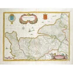
Normandia Ducatus.
Very decorative map of the Normandy coast. The map shows details of even the tiniest villages and prominently depicts the fortified cities. Numerous ships, fishing boats ...
Date: Amsterdam, 1656
Selling price: ????
Please login to see price!
Sold in 2012
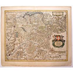
Sabaudia Ducatus Savoye
Lovely, very detailed map of Savoy with two cartouches: An ornamental title cartouche with two putti and a coat of arms and a strapwork scale cartouche. Features the two ...
Date: Amsterdam, 1656
Selling price: ????
Please login to see price!
Sold in 2013
Atrebates. Evesche d'Arras Comte d'Artois.
Fine copper engraved map of the French department of Nord-Pas-de-Calais. The map includes the cities of Douai, Lens, Cambrai and Bapaume. Very decorative ribboned title c...
Date: Paris, 1656
Selling price: ????
Please login to see price!
Sold in 2016
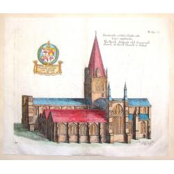
The North Prospect of ye Conuentuall Church of Christ in Oxford.
Hand-colored copper engraving of the Church of Christ in Oxford from Daniel King's "The Cathedrall & Conventuall Churches of England". King was a friend an...
Date: London, 1656
Selling price: ????
Please login to see price!
Sold in 2015
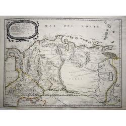
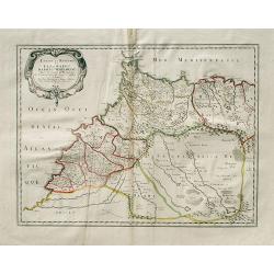
Terre Ferme ou sont les Governations, ou Gouvernemens de Terre Ferme, Cartagene, St. Marthe, Rio De la Hache, Venezuela, Nouvelle Andaluise, Popyan
A beautiful early map of the northern coast of South America, Venezuela and Columbia, showing the course of the Rio de Paria or Yuyapari or Orinaque River, Venezuela's Ca...
Date: Paris, 1656
Selling price: ????
Please login to see price!
Sold in 2020
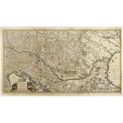
Totius Regni Hungarie et Adjacentium Regionum.
A beautiful, large, detailed map of southeastern Europe; featuring Hungary by Nicolas Visscher. Includes the regions of Northern Italy (showing the cities Bologna, Padua,...
Date: Amsterdam, 1656
Selling price: ????
Please login to see price!
Sold in 2018
Quercy olim Cadurcium.
Decorative map east to the top of the French province in the south-east of the country. With Cahors and the river Lot in the center.
Date: Amsterdam, 1656
Selling price: ????
Please login to see price!
Sold in 2020
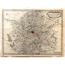
Borbonium Ducatus - Bourbonnois.
A fine map of the Bourbon in central France with nice detail of cities, villages, forests and rivers. Decorated with two beautiful cartouches flanked by musketeers and pu...
Date: Amsterdam, 1656
Selling price: ????
Please login to see price!
Sold in 2019