Browse Listings
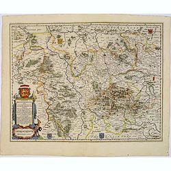
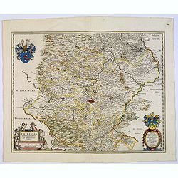
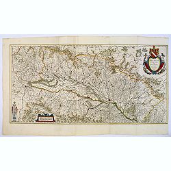
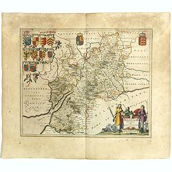
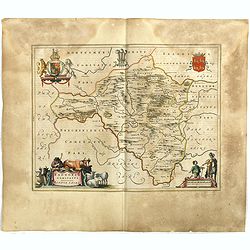
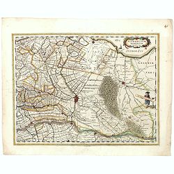
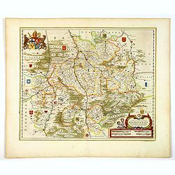
Ducatus Brunsvicensis fereq Lunaeburgensis. . .
Shows the Duchy of Braunschweig in detail with many locations. In the north it borders the Duchy of Lüneburg, in the south the Eichsfeldt, in the west to Minden, and eas...
Date: Amsterdam, 1645
Selling price: ????
Please login to see price!
Sold in 2017
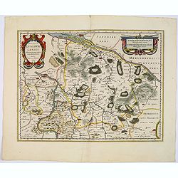
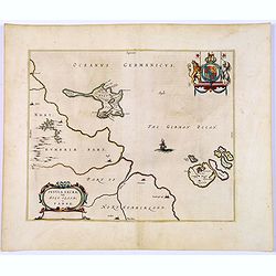
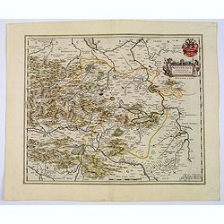
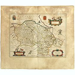
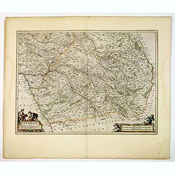
Ducatus Luneburgensis. . .
A very detailed Blaeu map centered on the Albis river, and the northern cities of Hamburg and Lunburg. Also shows Bremen. With a very decorative title cartouche. Scale ca...
Date: Amsterdam, 1645
Selling price: ????
Please login to see price!
Sold in 2017
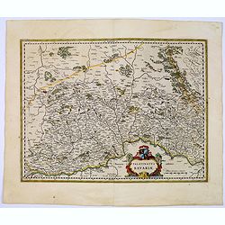
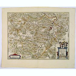
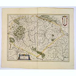
Palatinatus Bavariae.
Area north of Danube. Including the towns of Nuremberg, Ingolstadt, Regensburg, etc. Attractive title cartouche lower right portion of map.From early on Willem Jansz. Bla...
Date: Amsterdam, 1645
Selling price: ????
Please login to see price!
Sold in 2023
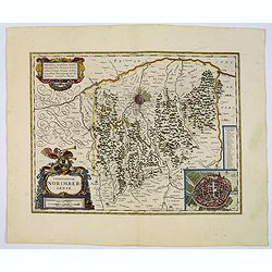
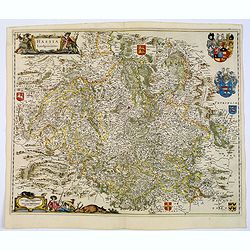
Territorium Norimbergense.
Centered on Nuremberg the capital of the printing shop of Homann. Lower right hand corner inset plan of Nuremberg, with a key to the major buildings. The large title cart...
Date: Amsterdam, 1645
Selling price: ????
Please login to see price!
Sold in 2022
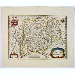
Erpach Comitatus.
Blaeu's regional map of Erpach, showing the region between the Rhine, Necar and Mayn Rivers, including Heidelberg and Erpach. Other cities include Dorfenbach, Miltenberg,...
Date: Amsterdam 1645
Selling price: ????
Please login to see price!
Sold in 2023

Nassovia Comitatus.
An elegantly engraved map of the region including Koblenz, Sigen and Dillenburg. The mountainous topography is graphically depicted and there is a coats of arms in the ri...
Date: Amsterdam, 1645
Selling price: ????
Please login to see price!
Sold in 2019
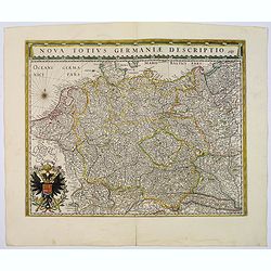
Nova Totius Germaniae Descriptio.
This map was prepared by the German cartographer Gaspher Henneberg of Erlich. Showing central Europe, including the Netherlands, Belgium, Luxemburg, part of Poland and Hu...
Date: Amsterdam, 1645
Selling price: ????
Please login to see price!
Sold in 2017

Bavaria Ducatus.
A beautiful map depicting the southern Germany province of Bavaria.Prepared by Gerard Mercator who is given credit in the attractive title cartouche. Plenty of map detail...
Date: Amsterdam, 1645
Selling price: ????
Please login to see price!
Sold in 2017
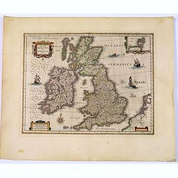
Magnae Britanniae et Hiberniae Tabula.
Map of Great Britain comprising England, Scotland, and Wales. Small inset map of the Orkneys, galleons, a compass rose, cartouches and sea-monster. French text on verso. ...
Date: Amsterdam, 1645
Selling price: ????
Please login to see price!
Sold in 2017
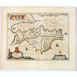
Vectis Insula. Anglice The Isle of Wight.
A beautifully engraved map seventeenth-century map of the Isle of Wight, just off the southern English coast. Features a nice decorative title cartouche in lower left cor...
Date: Amsterdam, 1645
Selling price: ????
Please login to see price!
Sold in 2018
Insula Sacra, Vulgo Holy Iland, et Farne.
Double-page map of Holy Island and Farne Island off the coast of Northumberland. The Abbey, the Old Fort and the town are clearly marked. Latin text on verso.Taken from J...
Date: Amsterdam, 1645
Selling price: ????
Please login to see price!
Sold in 2018
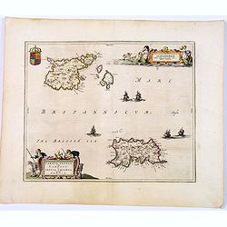
Sarnia insula vulgo Garnsey et Insula Caesarea. . . Garnsey. . .
Fine decorative map depicting the English Channel Islands of Jersey and Guernsey.Taken from Joan Blaeu's French edition Le Theatre du Monde, ou Nouvelle Atlas, Mise en l...
Date: Amsterdam, 1645
Selling price: ????
Please login to see price!
Sold in 2017
Tartaria sive Magni Chami Imperium.
A detailed and decorative map of Tartary and the northern part of China. The very northern tip of Korea included. The Chinese Great Wall is depicted, with Central Asia, e...
Date: Amsterdam, 1645
Selling price: ????
Please login to see price!
Sold in 2018
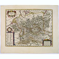
Germaniae veteris typus.
A very attractive historical map of Germany that was concepted after the map of Abraham Ortelius. It shows the area from the North Sea and Baltic Sea in the north to sout...
Date: Amsterdam, 1645
Selling price: ????
Please login to see price!
Sold in 2017
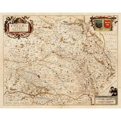
Thuringia Landgraviatus...
A beautifully detailed map of Thüringen, centered on Erfurt on the middle of the map, also showing Weimar. Embellished with a very decorative title cartouche surrounded ...
Date: Amsterdam, 1645
Selling price: ????
Please login to see price!
Sold in 2018
Mansfeldia Comitatus. . .
An attractive and detailed map centered on Mansfield, prepared by Tilemano Stella (1527-1589) a German cartographer who made maps of Germany and the Holy Land. Plenty of ...
Date: Amsterdam, 1645
Selling price: ????
Please login to see price!
Sold in 2021
Territorium Abbatiae Heresfeldensis. 't Stift Hirszfeldt.
A large seventeenth century hand colored map of the territory of Hirschfeld, (Hersfeld / Hesse) in Germany by Blaeu. It shows the Bad Hersfeld vicinity. There is Latin on...
Date: Amsterdam, 1645
Selling price: ????
Please login to see price!
Sold in 2021
Hassia Landgraviatus.
A very attractive map centered on the town of Kassel. With a decorative title cartouche. Latin text on verso, together with a beautiful mileage scale, regional heraldic a...
Date: Amsterdam, 1645
Selling price: ????
Please login to see price!
Sold in 2018
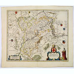
Archiepiscopatus Trevirensis.
An attractive map showing the area either side of the Moselle and Rhine rivers. Rhineland-Palatinate (Germany). Towns shown include: Trier, Kern, Gerrestein, Witlich, Cob...
Date: Amsterdam, 1645
Selling price: ????
Please login to see price!
Sold in 2017
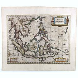
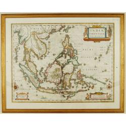
Indiae Orientalis nova descriptio.
An important map of South East Asia, noteworthy for being amongst the first maps to include any information on the discoveries made by the Dutch vessel Duyfkens in New Gu...
Date: Amsterdam, 1645
Selling price: ????
Please login to see price!
Sold in 2021
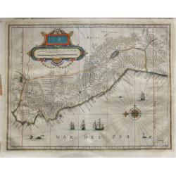
Peru.
French text edition. A map of Peru, orientated with north to the left, also showing most of Equador and Northern Chile, also includes Potosi, the famous mountain of silve...
Date: Amsterdam, 1645
Selling price: ????
Please login to see price!
Sold in 2018
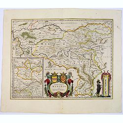
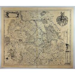
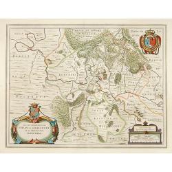
Comitatus Marchia et Ravensberg.
With an inset of Ravensberg comitatus in lower left corner. A central, decorative title cartouche with coats of arms. Mileage scale cartouche with a surveyor, lower right...
Date: Amsterdam, 1645
Selling price: ????
Please login to see price!
Sold
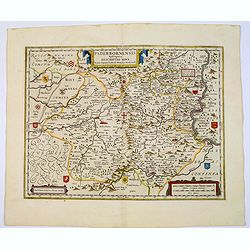
Paderbornensis Episscopatus Descriptio Nova.
An extremely detailed map centered on Paderborn. Prepared by Joannes Michael Gigas (1580-1650), a doctor, mathematician and geographer who made also maps of Osnabrug, Wes...
Date: Amsterdam, 1645
Selling price: ????
Please login to see price!
Sold in 2022
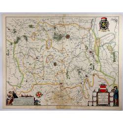
Palatinatus ad Rhenum.
Blaeu's attractive, detailed map of the Rheinpfalz, including Frankfurt and Heidelberg. It features an attractive separate coat-of-arms, a title, a scale of miles, and a ...
Date: Amsterdam, 1645
Selling price: ????
Please login to see price!
Sold in 2018
Flandriae Partes Duae. . .
A very detailed map with Ghent in the centre. Lower right corner is Antwerp, and Vlissingen in top right. At bottom left is a very decorative cartouche with a dedication ...
Date: Amsterdam, 1645
Selling price: ????
Please login to see price!
Sold in 2018
Prima Pars Brabantiae Cuius Caput Louanium.
A striking map showing the region of Loewen in the Duchy of Brabant in the Netherlands. Loewen and Tienen are shown prominently in the centre of the map. Inside the map a...
Date: Amsterdam, 1645
Selling price: ????
Please login to see price!
Sold in 2018
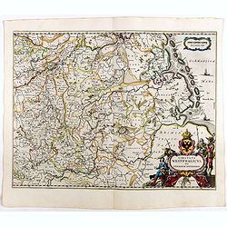
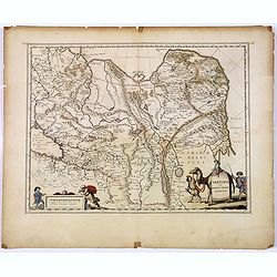
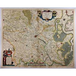
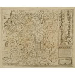
Circulus Westphalicus sive Germaniae Inferioris.
West orientated to the top, north to the right. A fine and detailed map by Blaeu of the northern part of Germany as far south to Düsseldorf, Waldeck and Paderborn.Lower ...
Date: Amsterdam, 1645
Selling price: ????
Please login to see price!
Sold in 2022
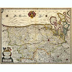
Comitatus Flandriae Nova Tabula.
Fine map of Flanders prepared by Henricus Hondius, the famous mapmaker.A beautiful ornamental title cartouche located on the lower left corner. Dedicated to Dr. Ionni d'H...
Date: Amsterdam, 1645
Selling price: ????
Please login to see price!
Sold in 2018
Nouvelle Description de l'Isle de Malte jadis Melita, et des Isles de Comin et Cominot, avec l'Isle et Principauté de Goze..
A very rare map of Malta, Gozo & Comino.
Date: Paris, 1645
Selling price: ????
Please login to see price!
Sold
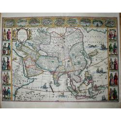
Asia Noviter Delineata.
A superb Carte-à-figures of Asia, adorned with five vignettes on either side which depict natives in mufti, and 9 small views of cities at the top, incl. Calcutta, Goa, ...
Date: Amsterdam, ca. 1645
Selling price: ????
Please login to see price!
Sold in 2020
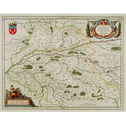
Alsatia Landgraviatus cum Suntgoia et Brisgoia.
Large map of Alsace based on the work of Gerard Mercator. Covers the region including the Rhine from Granville to Sarburg in the north and from Basel to Landaw in the sou...
Date: Amsterdam, 1645
Selling price: ????
Please login to see price!
Sold in 2018
Franconia vulgo Franckenlandt.
A fine copy centered on Bamberg, Nuremberg, Würzburg, and Nuremberg, Latin text on verso. With a decorative title cartouche adorned with two cherubs.As Willem Blaeu died...
Date: Amsterdam, 1645
Selling price: ????
Please login to see price!
Sold in 2023
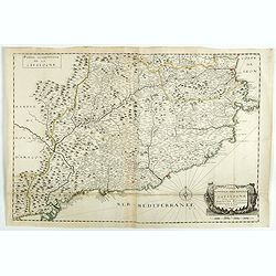
Nouvelle description de la principauté de Catalogne et des comtéz de Barcelone, Roussillon, Cerdagne et d'Ampurias. . .
A separately published and very rare two sheet map of Catalonia in original outline colors and compass rose.Apparently another recorded example of the map in Volume XV of...
Date: Paris, 1645
Selling price: ????
Please login to see price!
Sold in 2018
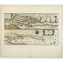
Celeberrimi Fluvii Albis nova delineatio.
A beautiful map of part of the river Elbe and Hamburg. The River Elbe is depicted in two sections from the mouth to Hamburg. The upper map hones in on the area immediatel...
Date: Amsterdam, 1645
Selling price: ????
Please login to see price!
Sold in 2018
Glocestria Ducatus, Vulgo Glocestershire.
Double-page map of the county of Gloucester. Shows cities of Bristol, Tewkesbury, Cheltenham, and Stroud. Decorative title cartouche lower right corner of shepherds and t...
Date: Amsterdam, ca. 1645
Selling price: ????
Please login to see price!
Sold in 2020
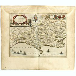
Comitatus Dorcestria, sive Dorsettia, Vulgo Anglice Dorset shire.
Double-page map of Dorsetshire county with decorative title and scale cartouches, six family coats of arms and two blank shields at bottom left.
Date: Amsterdam, ca. 1645
Selling price: ????
Please login to see price!
Sold in 2020
Wigorniensis Comitatus et Comitatus Warwicensis, nec non Coventrae libertas, Worcester, Warwic shire. And the Liberty of Coventre.
A double-page general map of the English counties of Warwickshire and Worcestershire with other towns such as Birmingham, Coventry, Leamington, Nuneaton, Kenilworth, Rugb...
Date: Amsterdam, ca. 1645
Selling price: ????
Please login to see price!
Sold in 2019
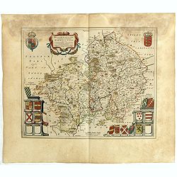
Leicestrensis Comitatus. Leicester shire.
Double-page map of the English county of Leicestershire. Decorative figurative and allegoric title cartouche with many heraldic family coat of arms on the bottom left por...
Date: Amsterdam, ca. 1645
Selling price: ????
Please login to see price!
Sold in 2020
Radnoria Comitatus. Radnor shire.
Double-page map of Radnorshire county, East of Wales. It is richly embellished with figurative title and scales cartouches, as well as coats of arms and royal arms.
Date: Amsterdam, ca. 1645
Selling price: ????
Please login to see price!
Sold in 2020
Denbigiensis Comitatus et Comitatus Flintensis, Denbigh et Flintshire.
Double-page map of Denbigshire and Flintshire, Wales with ornamental cartouches and armorials.
Date: Amsterdam, ca. 1645
Selling price: ????
Please login to see price!
Sold in 2020
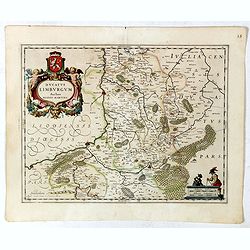
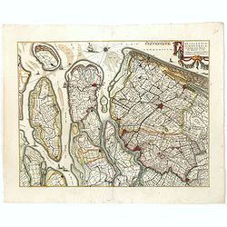
Ducatus Limburgum.
Decorative map of Belgium that is centered roughly on the Meuse River (Latin Mosa) and its cities of Hoy, Liege, and Maastricht. Finely detailed to show numerous towns an...
Date: Amsterdam, 1645
Selling price: ????
Please login to see price!
Sold in 2019
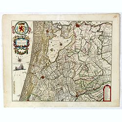
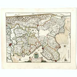
Rhenolandiae et Amstellandiae.
Encompasses the area between 's-Gravenhage and Gouda in the south, to Beverwijk in the north. Large expanse of the Haarlemmermeer occupies the center of the plate. A very...
Date: Amsterdam, 1645
Selling price: ????
Please login to see price!
Sold in 2019
![[Set of 11 maps of different regions of France]](/uploads/cache/43028-250x250.jpg)
[Set of 11 maps of different regions of France]
Set of 11 maps of different regions of France:- Gouvernement general du Lyonnois ( 410mm x 580mm)- Diocese de Rheims . . . ( 410mm x 520mm)- Gouvernement de la Cappelle (...
Date: Amsterdam, ca. 1645
Selling price: ????
Please login to see price!
Sold in 2020
Ultraiectum Dominium.
Based on the map by B.F.van Berckenrode (1620-21). A highly detailed map of Utrecht and its surroundings of The Netherlands. From a German edition of Blaeu's atlas.From e...
Date: Amsterdam, 1645
Selling price: ????
Please login to see price!
Sold in 2019
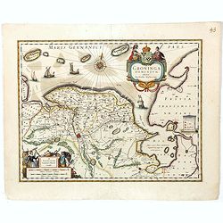
Groninga Dominium.
This finely proportioned, well-designed map was made by the Groningen patrician Barthold Wichering in 1616. An impressive title cartouche top right: key on plinth right c...
Date: Amsterdam, 1645
Selling price: ????
Please login to see price!
Sold in 2019
Delflandia, Schielandia.
This finely engraved map shows the estuary of the River Maas and includes the area from 's-Gravenhage to Gouda to Steenbergen and Ouddorp. Includes Rotterdam and Delft: G...
Date: Amsterdam, 1645
Selling price: ????
Please login to see price!
Sold in 2019
Hollandiae pars septentrionalis, Vulgo Westvriesland..
Based on the work of B.F.van Berckenrode, this fine map, orientated west to the top of the sheet, includes Kennemerland and Hollands Noorderkwartier and is a reasonably u...
Date: Amsterdam, 1645
Selling price: ????
Please login to see price!
Sold in 2019
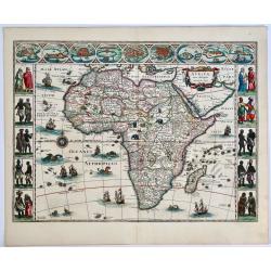
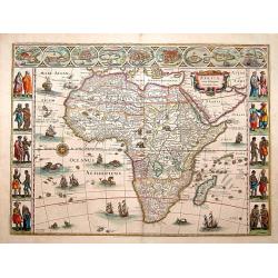
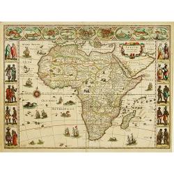
Africae Nova Descriptio.
A fine example of one of the most decorative early maps of Africa in original color. 2nd state of 1621-30. Latin text on verso. The top border panels consist of oval vign...
Date: Amsterdam, 1645
Selling price: ????
Please login to see price!
Sold in 2019
Mansfeldia Comitatus.
A pleasing detailed map of Mansfeld, Germany. Prepared by Tilemano Stella (1527-1589) a German cartographer who made maps of Germany and the Holy Land. Published by Blae...
Date: Amsterdam, 1645
Selling price: ????
Please login to see price!
Sold in 2019
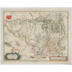
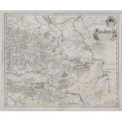
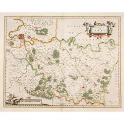
Lusatia Superior.
A detailed regional map of Lusatia, centered on Gorlitz, Germany and shows Zitta Lieba, Budissin, Seidenberg, Dresden, and Pirnaw. With two decorative cartouches and sma...
Date: Amsterdam, 1645
Selling price: ????
Please login to see price!
Sold in 2019
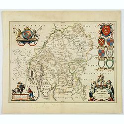
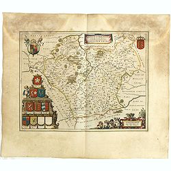
Westmoria Comitatus: Anglice Westmorland.
A double-page map of Westmorland county in the northwest of England. Two very decorative cartouches with putti and figures display the title and scale in the two lower co...
Date: Amsterdam, 1645
Selling price: ????
Please login to see price!
Sold in 2020
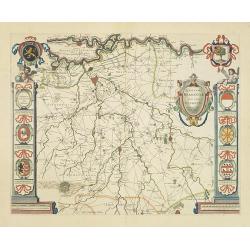
Episcopatus Hildesiensis descriptio novissima.
A fine and attractive mid-17th century folio sheet copper engraved map of the region around the Bishopric of Hildesheim, in Lower Saxony, the map includes numerous cities...
Date: Amsterdam, ca 1645
Selling price: ????
Please login to see price!
Sold in 2021
Senonois, & La Partie Meridionale de la Champagne.
A beautiful mid seventeenth-century map of Senonois and the southern region of Champagne in northern France. The region of Champagne, lying to the east of Paris, is one o...
Date: Amsterdam, ca 1645
Selling price: ????
Please login to see price!
Sold in 2021
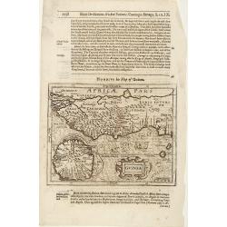
Guinea.
Samuel Purchas' edition of the Mercator/Hondius "Atlas Minor". Map of Guinea published in his famous collection of voyages "His Pilgrimes". With descr...
Date: London 1645
Selling price: ????
Please login to see price!
Sold
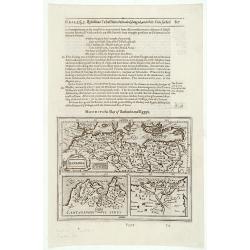
Barbaria / Egypt / Tunesia.
Samuel Purchas' edition of the Mercator/Hondius "Atlas Minor". Northern Africa published in his famous collection of voyages "His Pilgrimes". With des...
Date: London 1645
Selling price: ????
Please login to see price!
Sold
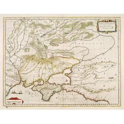
Taurica Chersonesus, Nostra aetate Prezecopsca, et Gazara dicitur.
Detailed map of the Ukraine, Russia with in the north Smolensk and Moscow and in the south the Black Sea. Shows ports, fortified cities and the mouths of the Danube. Mino...
Date: Amsterdam 1645
Selling price: ????
Please login to see price!
Sold
Le Pais de Brie.
A very decorative map with beautiful cartouches of a province of France by one of the most famous map publishers.
Date: Amsterdam 1645
Selling price: ????
Please login to see price!
Sold
Les Souverainetez de Sedan et de Raucourt.. Doncheri.
A very decorative map with beautiful cartouches of a province of France by one of the most famous map publishers.
Date: Amsterdam 1645
Selling price: ????
Please login to see price!
Sold
Africae nova descriptio.
Much of the geographical information is still based on the Ptolemaic maps, with the Nile shown with its source in the Lakes Zaire and Zaflan. Also included are various ot...
Date: Amsterdam 1645
Selling price: ????
Please login to see price!
Sold
Aethiopia inferior, vel exterior.
The standard map of South Africa throughout the 17th century. The lake out of which the 'Zambere' -the Zambesi- flows is probably based on reports of Lake Ngami, undiscov...
Date: Amsterdam 1645
Selling price: ????
Please login to see price!
Sold
Americae Nova Tabula.
The delineation of the coast and the nomenclature on both the Pacific and Atlantic coasts are basically Spanish in origin and follow the maps of Ortelius and Wytfliet. To...
Date: Amsterdam 1645
Selling price: ????
Please login to see price!
Sold
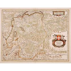
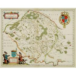
Sabaudia Ducatus.-Savoye.
Including town and Lake Geneva, Grenoble and the Alps.
Date: Amsterdam, 1645
Selling price: ????
Please login to see price!
Sold
Dioecese de Rheims, et le païs de Rethel.
A very decorative map with beautiful cartouches of a province of France by one of the most famous map publishers.
Date: Amsterdam 1645
Selling price: ????
Please login to see price!
Sold
Ducatus Turonensis.. Touraine.
A very decorative map with beautiful cartouches of a province of France by one of the most famous map publishers. Including the River Loire Valley with the towns of Tours...
Date: Amsterdam 1645
Selling price: ????
Please login to see price!
Sold
Vale Sium Ducatus. Valois
A very decorative map with beautiful cartouches of a province of France by one of the most famous map publishers.
Date: Amsterdam 1645
Selling price: ????
Please login to see price!
Sold in 2009
Fessae regnum.
The rare Samuel Purchas' edition of the Mercator/Hondius Atlas Minor atlas map. Early map of Morocco published in his famous collection of voyages His Pilgrimes . With de...
Date: London, 1645
Selling price: ????
Please login to see price!
Sold
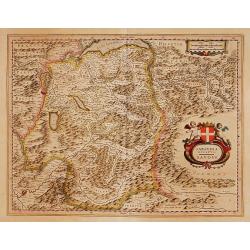
Sabaudia Ducatus. Savoye.
A very decorative map with beautiful cartouches of Savoie by one of the most famous map publishers. Showing Geneva and the Leman Lake on top of the map and Grenoble in th...
Date: Amsterdam 1645
Selling price: ????
Please login to see price!
Sold
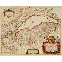
Lacus Lemanni Locorumque circumiacentium Accuratissima
Row boats and sailing vessels dot the surface of Lake Geneva, which is further enchanted by a compass rose radiating rhumb lines. The lake is surrounded by mountains and ...
Date: Amsterdam 1645
Selling price: ????
Please login to see price!
Sold
Africae nova descriptio.
Much of the geographical information is still based on the Ptolemaic maps, with the Nile shown with its source in the Lakes Zaire and Zaflan. Also included are various ot...
Date: Amsterdam 1645
Selling price: ????
Please login to see price!
Sold

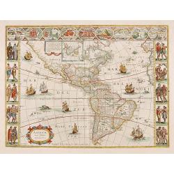
Americae Nova Tabula.
One of the best known and sought after seventeenth century maps of America. Blaeu's famous carte à figure map of America is regarded as a high point in Dutch cartography...
Date: Amsterdam 1645
Selling price: ????
Please login to see price!
Sold
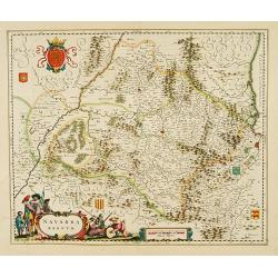
Navarra regnum.
With decorative title cartouche.
Date: Amsterdam, 1645
Selling price: ????
Please login to see price!
Sold
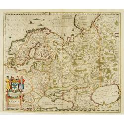
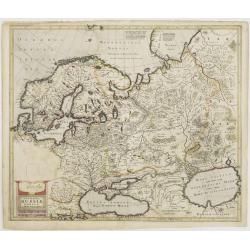
Novissima Russiae Tabula.
Detailed map of Russia including Scandinavia.Bottom left title cartouche and dedication. Prepared by Isaac Masso.
Date: Amsterdam 1645
Selling price: ????
Please login to see price!
Sold
Indiae Orientalis nova descriptio.
An important map of South East Asia, noteworthy for being amongst the first maps to include any information on the discoveries made by the Dutch vessel Duyfkens in New Gu...
Date: Amsterdam 1645
Selling price: ????
Please login to see price!
Sold
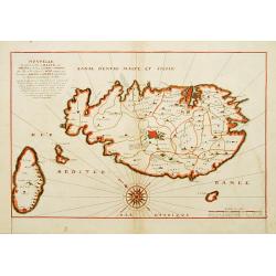
Nouvelle Description de l'Isle de Malte jadis Melita, et des Isles de Comin et Cominot, avec l'Isle et Principauté de Goze..
A separately published and very rare map of Malta, Gozo & Comino in brilliant original outlines colors, compass rose also in original colors. °
Date: Paris, 1645
Selling price: ????
Please login to see price!
Sold
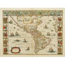
Americae Nova Tabula.
One of the best known and sought after seventeenth century maps of America. Blaeu's famous carte a figures map of America is regarded as a high point in Dutch cartography...
Date: Amsterdam 1645
Selling price: ????
Please login to see price!
Sold
Magni Ducatus Lithuaniae..
Detailed map of Poland and part of Russia up to the River Dnepr.
Date: Amsterdam 1645
Selling price: ????
Please login to see price!
Sold
Novissima Russiae Tabula.
Detailed map of Russia including Scandinavia.A rare PROFF-STATE: unfinished, empty space at bottom left for title cartouche and dedication. This is the second variant of ...
Date: Amsterdam, 1645
Selling price: ????
Please login to see price!
Sold in 2009
Quarta pars Brabantiae cujus caput Sylvaducis.
A good and dark impression in strong original colors.The third state. The coat of arms of Brabant and 's-Hertogenbosch appears on the map. The municipal arms in the colum...
Date: Amsterdam, 1645
Selling price: ????
Please login to see price!
Sold
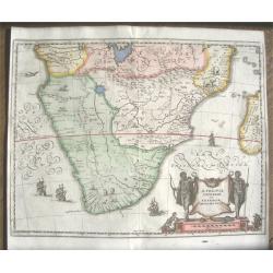
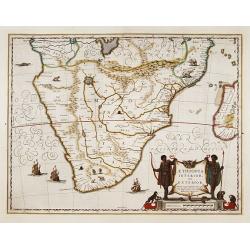
Aethiopia Inferior vel Exterior Monomotapa...
Very attractive and decorative double page map of the southern half of Africa. This map is an reduced version of the Bleau and Jansson maps. The area shown is from the Co...
Date: Frankfurt ca. 1645
Selling price: ????
Please login to see price!
Sold
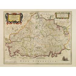
Comitatus Lageniae. The Countie of Leinster.
Finely engraved map of the eastern part of Ireland. Orientated with the West on top. Decorated with vessels, title cartouche and scale of miles cartouche. Relief shown pi...
Date: Amsterdam 1645
Selling price: ????
Please login to see price!
Sold