Browse Listings
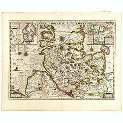
Ducatus Holsatiae nova tabula.
Beautiful map of Schleswich Holstein covering the region from Hussum till Hamburg, with numerous place-names of cities, towns, villages, forests and castles. With two ins...
Date: Amsterdam, 1635
Selling price: ????
Please login to see price!
Sold in 2016
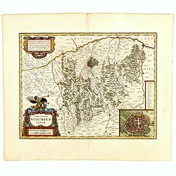
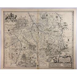
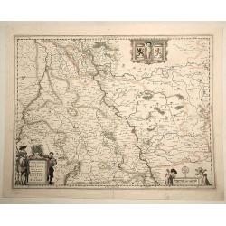
Territorium Norimbergense.
Centered on Nuremberg the capital of the printing shop of Homann. Lower right hand corner inset plan of Nuremberg. Very fine.As Willem Blaeu died in 1638 most of his maps...
Date: Amsterdam, 1635
Selling price: ????
Please login to see price!
Sold in 2015
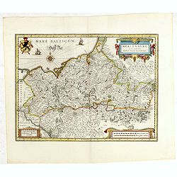
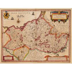
Meklenburg Ducatus...
Finely engraved map with a very decorative title cartouche adorned with a chain of fruits. A ship is sailing on the Baltic near a wind rose. In the left-hand upper part, ...
Date: Amsterdam, 1635
Selling price: ????
Please login to see price!
Sold in 2015
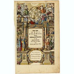
Ander Theil Novi Atlantis Das ist Abbildung und Beschreibung von allen Ländern des Erdreichs. . .
Architectural frontage with a wealth of figures.
Date: Amsterdam, 1635
Selling price: ????
Please login to see price!
Sold in 2016
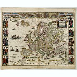
Europa recens descripta à Guilielmo Blaeuw.
On either side columns depicting the manner of dress in the major countries of Europe, surmounted by nine city views and plans.For European mapmakers their own continent ...
Date: Amsterdam, 1635
Selling price: ????
Please login to see price!
Sold in 2016
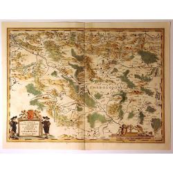
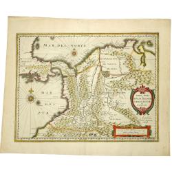
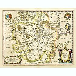
Les Environsde L'Estang de Longpendu Comprenant une Grande Partie du COMTÉ DE CHAROLOIS par Jean van Damme Sr. d'Amendale.
Gorgeous regional map of France, showing a portion of Charolois with lands belonging to the Duke of Charolais, an area between Dijon and Lyon in France. Two large decorat...
Date: Amsterdam, ca. 1635
Selling price: ????
Please login to see price!
Sold in 2016
La Principauté d'ORANGE et Comtat de VENAISSIN. Par Jacques de Chieze.
A beautiful map of Orange and Avignon, decorated with finely engraved title cartouches. South to the top. Lower right early signature of Willem Blaeu: Guiljelmus Janssoni...
Date: Amsterdam , ca. 1635
Selling price: ????
Please login to see price!
Sold in 2022
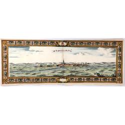
Moyenvic Lorraine, 1631
A striking and highly decorative, unusual copper engraved panoramic view of Moyenvic on the Sealle River in the region of Lorraine in France.With fortifications surroundi...
Date: Paris, ca. 1635
Selling price: ????
Please login to see price!
Sold in 2016
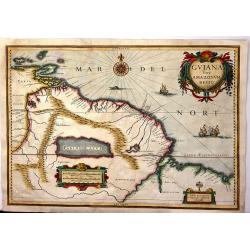
Guiana Siue Amazonu, Regio
Striking. 1635 map of the northwestern part of South America including Lake Parima (Parime Lacus), and the route to El Dorado. The map covers from Isla Margarita and the ...
Date: Amsterdam, 1635
Selling price: ????
Please login to see price!
Sold in 2016
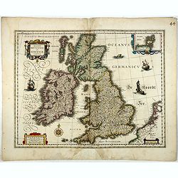
Magnae Britanniae et Hiberniae Tabula.
A finely engraved map from the most important Dutch map publishers of the 17th century. The plate was acquired by the Blaeu's from Jodocus Hondius Jr. in 1629, and was re...
Date: Amsterdam, 1635
Selling price: ????
Please login to see price!
Sold in 2017
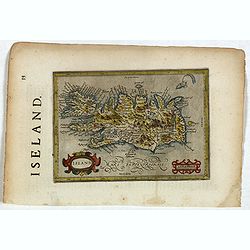
Island.
Map of Iceland from the rare English text edition of Jodocus Hondius' "Historia mundi, or, Mercator's Atlas. Containing his Cosmographical Description of the Fabrick...
Date: Michael Sparke and Samuel Cartwright, 1635
Selling price: ????
Please login to see price!
Sold in 2021
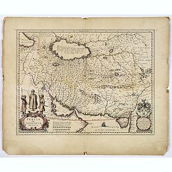
Persia sive Sophorum Regnum.
A finely designed map from the great Blaeu family of Amsterdam. An antique map of Persia that stretches from the Caucasus to Afghanistan, and from the Deserts of Arabia t...
Date: Amsterdam, ca. 1635
Selling price: ????
Please login to see price!
Sold in 2018
Episcopatus Hildesiensis Descriptio Novissima.
A fine and attractive mid-17th century folio sheet copper engraved map of the region around Hildesheim, in Lower Saxony. It includes numerous cities and corresponding coa...
Date: Amsterdam, 1635
Selling price: ????
Please login to see price!
Sold in 2018

Meklenburg Ducatus...
Finely engraved map with a very decorative title cartouche adorned with a chain of fruits. A ship is sailing on the Baltic near a wind rose. In the left-hand upper part, ...
Date: Amsterdam, 1635
Selling price: ????
Please login to see price!
Sold in 2020
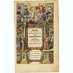
(Title page) Ander Theil Novi Atlantis Das ist Abbildung und Beschreibung von allen Ländern des Erdreichs. . .
Architectural frontage with a wealth of figures, among them figures representing astronomy and geography surveying a celestial and terrestrial globe. Other figures repres...
Date: Amsterdam, 1635
Selling price: ????
Please login to see price!
Sold in 2019
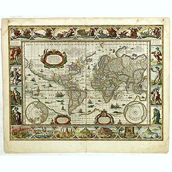
Nova Totius Terrarum Orbis Geographica Ac Hydrographica Tabula auct Guiljelmo Blaeuw.
Sought-after world map by one of the most famous Dutch mapmakers. The paneled borders show, at the top allegorical representations of the sun, moon and the five known pla...
Date: Amsterdam, 1635
Selling price: ????
Please login to see price!
Sold in 2018
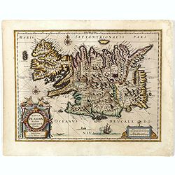
Tabula Islandiae. . .
This handsome map of Iceland was based on information from a Dutch navigator named Joris Carolus in about 1620. The map shows the influence of both versions of bishop Gud...
Date: Amsterdam, 1635
Selling price: ????
Please login to see price!
Sold in 2019
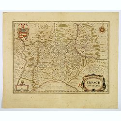
Erpach Comitatus.
An elegantly engraved Dutch map of the early seventeenth century of the region including Heidelberg, centered on Eparch and showing part of the River Rhine and River Main...
Date: Amsterdam, ca 1635
Selling price: ????
Please login to see price!
Sold in 2021
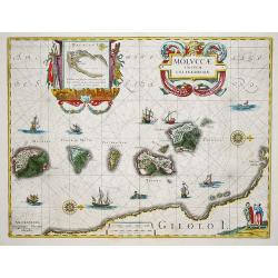
Moluccae Insulae Celeberrimi.
Willem Blaeu's very fine map of the Spice islands, with a detailed map of the Island of Bachian in a handsome border. Further embellished with a large title-cartouche, an...
Date: Amsterdam, ca 1635
Selling price: ????
Please login to see price!
Sold in 2019
Iulacensis et Montensis Ducatus de Hertoghdomen Gulick en Berghe.
A fine map showing the Duchies of Julich and Berg on both sides of the Rhine River between Bonn and Wesel. Centered on Dusseldorf and reaching to Maastricht in the west a...
Date: Amsterdam, 1635
Selling price: ????
Please login to see price!
Sold in 2019
TERRA FIRMA et NOVUM REGNUM GRANATENSE et POPAYAN.
A fine example of this handsome map of modern-day Panama and Colombia. Decorated with a cartouche, a distance memorandum and two rose compasses. Very fine and rare. Frenc...
Date: Amsterdam, 1635
Selling price: ????
Please login to see price!
Sold in 2019
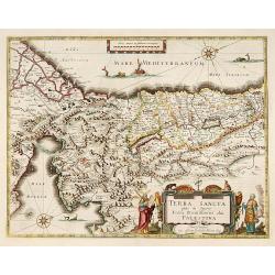
Terra Sancta quae in Sacris Terra Promissionis..
Very decorative map of Palestine. Orientated west to the top. The decoration is inspired by the Old Testament. Moses stands to the left of the title cartouche, Aaron to t...
Date: Amsterdam 1635
Selling price: ????
Please login to see price!
Sold
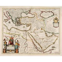
Turcicum Imperium.
A very handsome map with a particularly fine cartouche showing the Turkish Sultan on his throne and allegorical figures at either side brandishing weapons. At right is a ...
Date: Amsterdam 1635
Selling price: ????
Please login to see price!
Sold
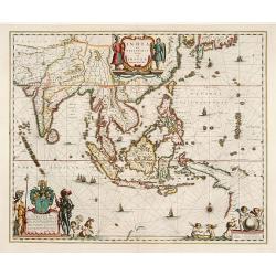
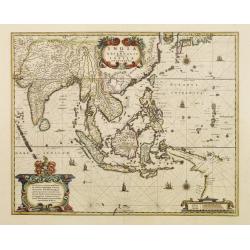
India quae Orientalis..
Extending from India to Japan and showing parts of Australia. It is indeed one of the first printed maps to show identifiable parts of Australia. It was not revised until...
Date: Amsterdam 1635
Selling price: ????
Please login to see price!
Sold
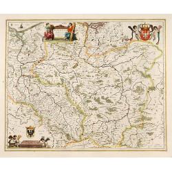
Polonia regnum et Silesia ducatus
Very decorative map of Poland embellished with two cartouches and two coats of arms surmounted by cherubs and female figures.
Date: Amsterdam 1635
Selling price: ????
Please login to see price!
Sold
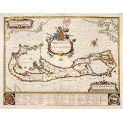
Mappa Aestivarum Insularum alias Barmudas.
Blaeu based his work on John Speed's remarkably accurate map of 1626-1627. It shows the island divided into tribes and lots, and below the map itself appear the names of ...
Date: Amsterdam 1635
Selling price: ????
Please login to see price!
Sold
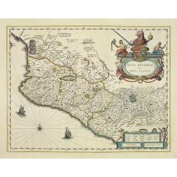
Nova Hispania et Nova Galicia.
Based on Ortelius' map of 1579 which became the basis for many of the seventeenth century maps of the area. A splendid and colored title cartouche with two allegorical fi...
Date: Amsterdam, 1635
Selling price: ????
Please login to see price!
Sold in 2022
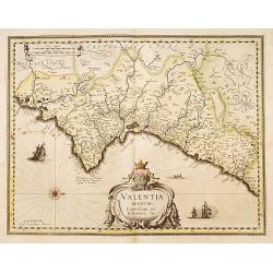
Valentia regnum Contestani, Ptol. Edentani, Plin.
Fine map of the Spanish province of Valencia, with large title cartouche and Dutch vessels offshore. West on top.Dutch text on verso. In original outline line color, with...
Date: Amsterdam 1635
Selling price: ????
Please login to see price!
Sold
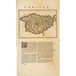
Corsica.
Map of Corsica. East on top.Dutch edition. In original outline line color, with some later color additions.
Date: Amsterdam 1635
Selling price: ????
Please login to see price!
Sold
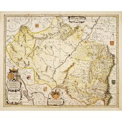
Arragonia regnum.
A beautiful, highly decorative map of Aragon, centered on Saragossa and extending to Balbasdtor, Huesca, Calataiud, Tortosa, Tervel, Albarrazin and Cuenca. Towns, rivers,...
Date: Amsterdam 1635
Selling price: ????
Please login to see price!
Sold
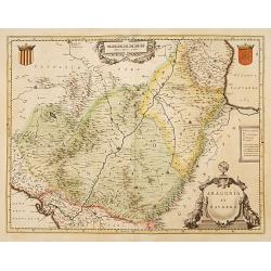
Aragonia et Navarra.
A fine map of the Spanish provinces of Aragon and Navarre, centered on Saragossa and Pamplona. Towns, rivers, mountains, lakes and valleys are depicted.Dutch text on vers...
Date: Amsterdam 1635
Selling price: ????
Please login to see price!
Sold
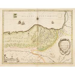
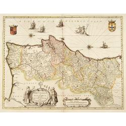
Biscaia et Guipuscoa Cantabriae Veteris.
Shows cities of Bilbao and Laredo, and includes a charming vignette of a putti with surveying equipment, being observed by a kitten.Dutch text on verso. In original outli...
Date: Amsterdam 1635
Selling price: ????
Please login to see price!
Sold
Legionis regnum..
Decorative map of the Spanish Province Asturias, Castile and Léon, including the towns of Oviedo, León, Santander, Valladolid, etc. With two fine ti...
Date: Amsterdam 1635
Selling price: ????
Please login to see price!
Sold
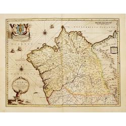
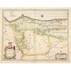
Gallaecia, regnum..
A beautiful map of Galicia in Spain, decorated with finely engraved and windroses, sailing boats, a triton [supporter of the God Neptune] as bearer of the title cartouche...
Date: Amsterdam 1635
Selling price: ????
Please login to see price!
Sold
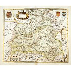
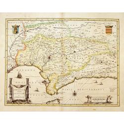
Utriusque Castiliae.
Ornate and richly embellished map of Castillia, showing Saragossa, Valencia, Alicante, Cartagena, Madrid, Cordoba, Seville, Salamanca, Palencia, Segovia, Toledo, Cuenca, ...
Date: Amsterdam 1635
Selling price: ????
Please login to see price!
Sold
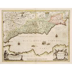
Granata et Murcia regna.
A fine copy decorated with the Arms of both States and the figure of a surveyor. Extending from the Straits of Gibraltar to Alicante as far inland as the Guagalquivir val...
Date: Amsterdam 1635
Selling price: ????
Please login to see price!
Sold
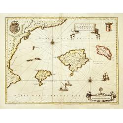
Insulae Balearides..
A map of Mallorca and Minorca and with Ibiza and Formentera, called the Pytuisae Islands, with the coastline from Barcelona to Denia.Dutch text on verso. In original outl...
Date: Amsterdam 1635
Selling price: ????
Please login to see price!
Sold
Andaluzia continens Sevillam..
Features the province of Andalusia and the city of Seville, but also depicts the Straights of Gibraltar, know in classical times as the Pillars of Hercules. The title car...
Date: Amsterdam 1635
Selling price: ????
Please login to see price!
Sold
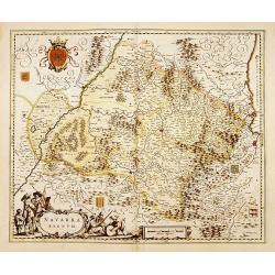
Navarra regnum.
Decorative map of the Spanish Province of Navarra centered on Pampelona. Showing the french city of Bayonne. West on top. Towns, rivers, mountains, lakes and valleys are ...
Date: Amsterdam 1635
Selling price: ????
Please login to see price!
Sold
Portugallia et Algarbia quae olim Lusitania.
Prepared by Fernando Alvarez Secco, a Portuguese map maker who's map was used by various publishers till the end of the 17th century.Dutch text on verso. In original outl...
Date: Amsterdam 1635
Selling price: ????
Please login to see price!
Sold
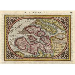
Zelandia Comitatus.
Finely engraved oval map showing the south-western part of the Netherlands, Province of Zeeland. Strapwork title cartouche and intricate surrounding border. German text o...
Date: Amsterdam 1635
Selling price: ????
Please login to see price!
Sold
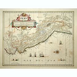
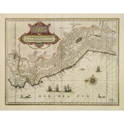
Peru.
Decorated with ships and monsters on the sea. Orientated with east at the top. A most attractive item.
Date: Amsterdam 1635
Selling price: ????
Please login to see price!
Sold
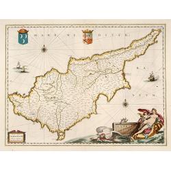
Cyprus Insulae.
Blaeu's beautiful map of Cyprus embellished with a very decorative title cartouche, a scale cartouche, two coats of arms, two wind roses and three sailing ships.
Date: Amsterdam, 1635
Selling price: ????
Please login to see price!
Sold in 2016
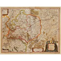
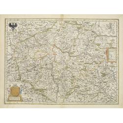
Sueviae nova tabula
Beautiful map of Swaben, including Ulm, Augsburg, Stuttgart, Zürich, Lucerne and Lake Constance.Originally, we owe the first edition of this map to Jodocus Hondius. On J...
Date: Amsterdam, 1635
Selling price: ????
Please login to see price!
Sold in 2016
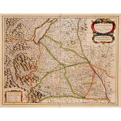
Alemania sive suevia superior
Map of Upper Schwabenland, with the BodenSee in upper left corner. French text edition. Two colored title and key cartouches.
Date: Amsterdam, 1635
Selling price: ????
Please login to see price!
Sold in 2016
Meklenburg Ducatus.
Finely engraved map with a very decorative title cartouche adorned with a chain of fruits. A ship is sailing on the Baltic near a wind rose. In the left-hand upper part, ...
Date: Amsterdam, 1635
Selling price: ????
Please login to see price!
Sold in 2017
Virginiae Partis Australis, et Floridae Partis Orientalis.
This beautifully engraved map is based on the Mercator-Hondius work of 1606, with a significant number of geographic changes / improvements, particularly along the Caroli...
Date: Amsterdam, ca. 1635
Selling price: ????
Please login to see price!
Sold
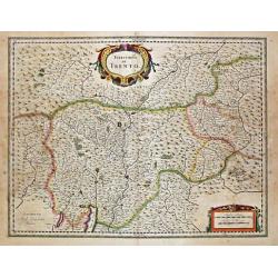
Territorio di Trento.
\"Willem Blaeu, founder of the famous publishing firm. Originally publishing pilot-guides, he issued his first atlas, \"Atlantis Appendix\", in 1630, follo...
Date: Amsterdam, 1635
Selling price: ????
Please login to see price!
Sold in 2009
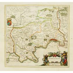
Middle-Sexia.
A finely engraved map of the area north of London, from the most important Dutch map publishers of the 17th century.
Date: Amsterdam 1635
Selling price: ????
Please login to see price!
Sold
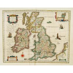
Magnae Britanniae et Hiberniae Tabula.
A finely engraved map from the most important Dutch map publishers of the 17th century. The plate was acquired by the Blaeu's from Jodocus Hondius Jr. in 1629, and was re...
Date: Amsterdam 1635
Selling price: ????
Please login to see price!
Sold
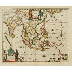
India quae Orientalis..
Extending from India to Japan and showing parts of Australia. It is indeed one of the first printed maps to show identifiable parts of Australia. It was not revised until...
Date: Amsterdam 1635
Selling price: ????
Please login to see price!
Sold
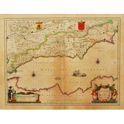
Granata et Murcia regna.
A fine copy decorated with the Arms of both States and the figure of a surveyor. Extending from the Straits of Gibraltar to Alicante as far inland as the Guagalquivir val...
Date: Amsterdam 1635
Selling price: ????
Please login to see price!
Sold
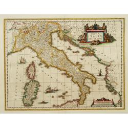
Nova Italiae delineatio.
Detailed map of Italy, Sardinia and Corsica embellished with four sailing ships, a sea monster and two very decorative scale and title cartouches.
Date: Amsterdam 1635
Selling price: ????
Please login to see price!
Sold
Freti Magellanici ac novi Freti vulgo Le Maire..
Early impression of this fine map of Tierra del Fuego. Hondius added a Dutch translation of the explanatory text of the passage by Barent Jansz. Potgieter who accompanied...
Date: Amsterdam 1635
Selling price: ????
Please login to see price!
Sold
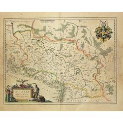
Silesia Ducatus.
Willem Blaeu, founder of the famous publishing firm. Originally publishing pilot-guides, he issued his first atlas, 'Atlantis Appendix', in 1630, followed by his "Th...
Date: Amsterdam, 1635
Selling price: ????
Please login to see price!
Sold
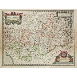
Montisferrati Ducatus.
Willem Blaeu, founder of the famous publishing firm. Originally publishing pilot-guides, he issued his first atlas, 'Atlantis Appendix', in 1630, followed by his "Th...
Date: Amsterdam, 1635
Selling price: ????
Please login to see price!
Sold in 2013
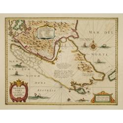
PERU.
Decorative map of Peru, shows the Pacific coast of South America from Ecuador (at the left-hand side) as far south as the Atacama desert in the northern reaches of Chile....
Date: Amsterdam 1635
Selling price: ????
Please login to see price!
Sold
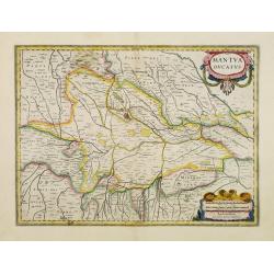
Mantua ducatus.
Centered on the town of Mantua.
Date: Amsterdam 1635
Selling price: ????
Please login to see price!
Sold
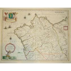
GALLAECIA REGNUM
A highly desirable map of the Spanish province of Galicia, located in the northwest corner of Iberia. This work contains two decorative cartouches, compass roses, sailin...
Date: Amsterdam, 1635
Selling price: ????
Please login to see price!
Sold
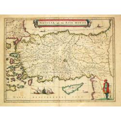
Natolia quae olim Asia Minor.
A finely designed map of Turkey and Cyprus from the great Blaeu family of Amsterdam. The decoration consist of a colored title cartouche, sea monsters, a naval engagement...
Date: Amsterdam, c. 1635
Selling price: ????
Please login to see price!
Sold in 2016
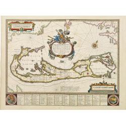
Mappa Aestivarum Insularum alias Barmudas.
Blaeu based his work on John Speed's remarkably accurate map of 1626-1627. It shows the island divided into tribes and lots, and below the map itself appear the names of ...
Date: Amsterdam 1635
Selling price: ????
Please login to see price!
Sold
India quae Orientalis..Insulae Adiacentes.
An important Dutch map of South East Asia, noteworthy for being the first map to include, albeit incompletely, the discoveries made by the Dutch vessel Duyfken in 1605-06...
Date: Amsterdam 1635
Selling price: ????
Please login to see price!
Sold
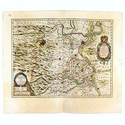
Territorium Metense.
A beautiful colored engraved map centred on Metz in France. Cartouche decorated with a chain of leaves and fruits and three coats of arms. The author of this map was the ...
Date: Amsterdam, 1635
Selling price: ????
Please login to see price!
Sold in 2009
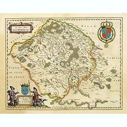
Valesium Ducatus. Valois
The map shows the area between Senlis, Compiègne, Soissons and Meaux which was the ancient duché de Valois. In the left-hand lower part of the image a beautiful cartouc...
Date: Amsterdam, 1635
Selling price: ????
Please login to see price!
Sold in 2009
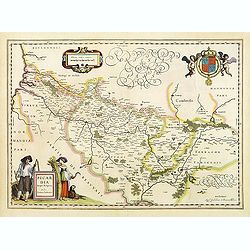
Picardia Regio Belgica, Auctore Ioanne Surhonio.
A map of Picardie centered on the city of Amiens. Two beautiful and colored cartouches. The one in the left-hand lower part is decorated with two human figures. In the up...
Date: Amsterdam, 1635
Selling price: ????
Please login to see price!
Sold in 2009
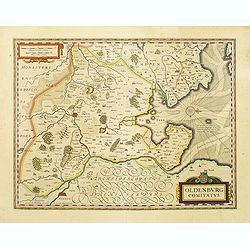
Oldenburg Comitatus.
Willem Blaeu's attractive map of Oldenburg, also depicting Bremen. From the French edition of Willem Blaeu's atlas "Theatrum".
Date: Amsterdam, 1635
Selling price: ????
Please login to see price!
Sold in 2022
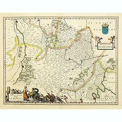
Belsia, Vulgo la BEAUSSE.
In the left-hand lower part of the image a beautiful contemporary colored cartouche with goddess Ceres [agricultural] holding a reaping-hook in her right hand and receivi...
Date: Amsterdam, 1635
Selling price: ????
Please login to see price!
Sold in 2013
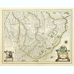
Champagne latine Campania, comitatus.
A good engraved map embellished with two decorative scale cartouches showing putti.
Date: Amsterdam, 1635
Selling price: ????
Please login to see price!
Sold in 2015
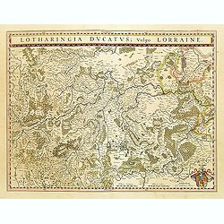
Lotharingia Ducatus Vulgo LORRAINE.
This is a map of Lorraine with a coat of arms.
Date: Amsterdam, 1635
Selling price: ????
Please login to see price!
Sold in 2009
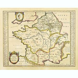
Gallia Vetus, Ad iul Caesaris Commentaria, ex conatibus geographicis Abrah Ortelii.
Decorative map depicting the Roman Empire during Caesar.
Date: Amsterdam, 1635
Selling price: ????
Please login to see price!
Sold
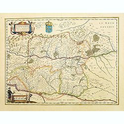
Lionnois, Forest, Beaujolois et Masconnois.
A map of the northern area of Lyon. In the left-hand upper part, a cartouche with two cherubs and a coast of arms.In the left-hand lower part, a third putti with surveyor...
Date: Amsterdam, 1635
Selling price: ????
Please login to see price!
Sold
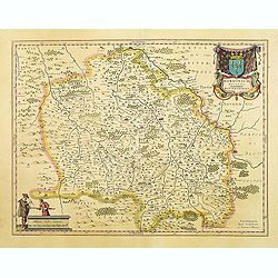
BORBONIUM Ducatus BOURBONNOIS.
Decorative map of the area called Bourbonnais. In the Top left-hand corner, a big cartouche with title and coast of arms. In the opposite corner, a smaller cartouche with...
Date: Amsterdam, 1635
Selling price: ????
Please login to see price!
Sold in 2009
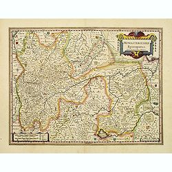
Monasteriensis Episcopatus.
A very detailed map of Germany centered on Munster and Linge. Also showing Wessel to the top of the map and Oldenburg to the right. North to the right. The map is adorned...
Date: Amsterdam, 1635
Selling price: ????
Please login to see price!
Sold in 2021
Bohemia.
Willem Blaeu, founder of the famous publishing firm. Originally publishing pilot-guides, he issued his first atlas, 'Atlantis Appendix', in 1630, followed by his "Th...
Date: Amsterdam, 1635
Selling price: ????
Please login to see price!
Sold in 2011
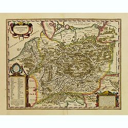
Germaniae veteris typus
A very attractive historical map of Germany was concepted after the map of Abraham Ortelius. It shows the area from the North Sea and Baltic Sea in the north to south of ...
Date: Amsterdam, 1635
Selling price: ????
Please login to see price!
Sold
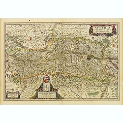
Austria Archiducatus auctore Wolfgango Lazio.
Showing the Danube and its cities. Bordering Bohemia, Moravia, Salzburg, Corinthian and Styria. Vienna is prominently featured and the map is filled with villages, cities...
Date: Amsterdam, 1635
Selling price: ????
Please login to see price!
Sold in 2017
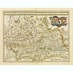
Saltzburg Archiepiscopatus, et Carinthia Ducatus.
A beautiful map showing an Austrian region with a splendid decoration consisting of two big coats of arms between three cherubs.
Date: Amsterdam, 1635
Selling price: ????
Please login to see price!
Sold in 2015
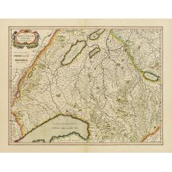
Das Wiflispurgergow. Gerardo Mercatore Auctore.
Finely engraved map including in the left-hand lower part Geneva and Lake Geneva with Lausanne and in center of the map, the cantons of Fribourg and Bern.
Date: Amsterdam, 1635
Selling price: ????
Please login to see price!
Sold in 2013
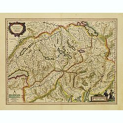
Helvetia cum finitimis regionibus confoederatis.
Date: Amsterdam, 1635
Selling price: ????
Please login to see price!
Sold
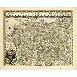
Nova totius germaniae descriptio.
Detailed and finely engraved map of Germany, Poland, Netherlands, Belgium, Austria and a little part of Italy and Croatia. Embellished with an enormous title cartouche al...
Date: Amsterdam, 1635
Selling price: ????
Please login to see price!
Sold in 2018