Browse Listings
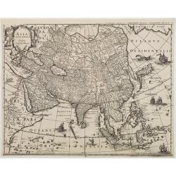
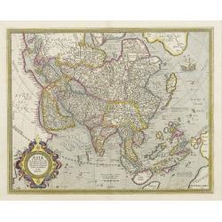
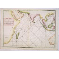
Asia noviter delineata.
Very detailed map of Asia showing animals and natives on the continent, sea monsters, sailing ships and a decorative title cartouche with two natives.During the printing ...
Date: Amsterdam 1633
Selling price: ????
Please login to see price!
Sold
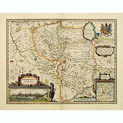
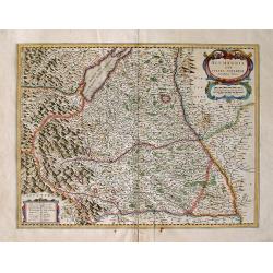
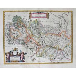
Osnabrugensis episcopatus.
A beautiful map of Münster centered on the city of Osnabruck. Prepared by Joannes Michael Gigas (1580-1650+), a doctor, mathematician and geographer. Showing an inset wi...
Date: Amsterdam, 1633
Selling price: ????
Please login to see price!
Sold in 2017
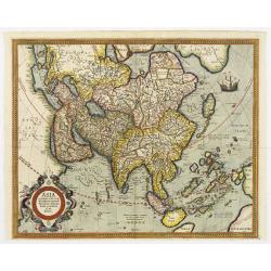
Asia noviter delineata.
During the printing process the figured borders have been covered. No text on verso. There exists a continent map of the Americas which has been printed in the same way. ...
Date: Amsterdam, 1633
Selling price: ????
Please login to see price!
Sold in 2016
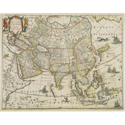
Asia ex magna Orbis terre descriptione Gerardi Mercatoris..
The cartography derives directly from the 1569 Mercator world map and includes the southern landmasses of New Guinea and Terra Australis, the East Indian Islands, the Phi...
Date: Amsterdam, 1595-1633
Selling price: ????
Please login to see price!
Sold in 2008
Asia ex magna Orbis terre descriptione Gerardi Mercatoris..
The cartography derives directly from the 1569 Mercator world map and includes the southern landmasses of New Guinea and Terra Australis, the East Indian Islands, the Phi...
Date: Amsterdam, 1633
Selling price: ????
Please login to see price!
Sold
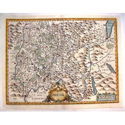
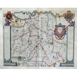
Bresse
Detailed map of Bresse in the Burgundy region of France. French text describing Bresse is on verso. Large decorative cartouche. From Atlas, das ist, Abbildung der Gantzen...
Date: Amsterdam, 1633
Selling price: ????
Please login to see price!
Sold in 2013
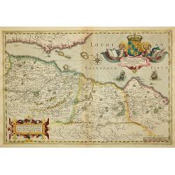
A New Description of the Shyres Lothian and Linlitquo. Be T.Pont.
A Scottish clergyman, Timothy Pont's survey of Scotland of 1595-1608 made that country the best mapped in the world. However it was not until Blaeu issued the maps as Vol...
Date: Amsterdam, 1633
Selling price: ????
Please login to see price!
Sold in 2011
![[Titlepage] Atlas ou representation du Monde. . .](/uploads/cache/25954-250x250.jpg)
[Titlepage] Atlas ou representation du Monde. . .
Architectural frontage with personifications of the four Continents, Atlas, Peruana, and Magalanica.Together with a text page, "advertissement au lecteur" and o...
Date: Amsterdam, 1633
Selling price: ????
Please login to see price!
Sold in 2008
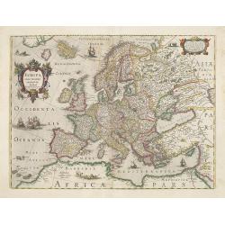
Europa exactissime descripta.
Very decorative map of Europe decorated with many ships and sea monster. Dated 1631.
Date: Amsterdam, 1633
Selling price: ????
Please login to see price!
Sold in 2009
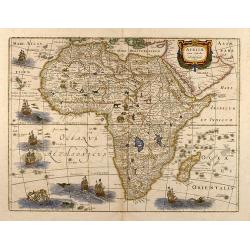
Africae nova tabula
Attractive colored map of Africa. Various animals appear in Africa, sea monsters and fishes in the ocean. It was publish first 1619 by Jodocus Hondius with four decorativ...
Date: 1633
Selling price: ????
Please login to see price!
Sold in 2009
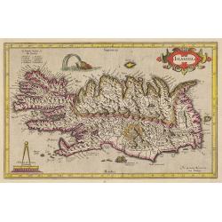
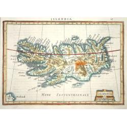
Islandia.
A very nice map from Iceland showing a sea monster and exploding volcano.Mercator was born in Rupelmonde in Flanders and studied in Leuven under Gemma Frisius, Dutch writ...
Date: Amsterdam, 1633
Selling price: ????
Please login to see price!
Sold in 2009
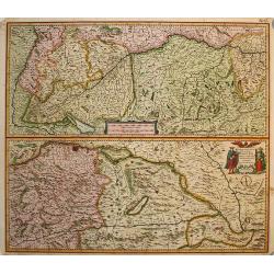
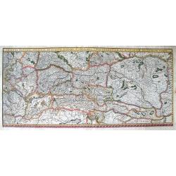
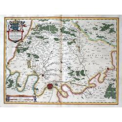
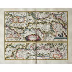
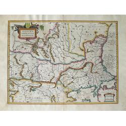
Maximi Totius Europae Fluminis Danubii
Two copper engraved maps on one sheet that detail the flow of the Danube from its source in Germany near the Boden See (Lake Constance) to Belgrade. Very fine detail alon...
Date: Amsterdam, 1633
Selling price: ????
Please login to see price!
Sold in 2009
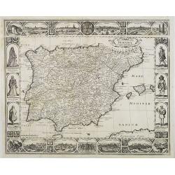
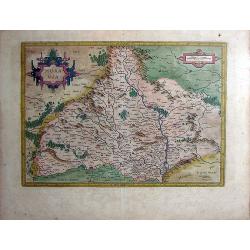
Nova et accurata Tabula Hispaniae . . .
An extremely rare "carte à figures" map of Spain and Portugal. Second state. The map shows the geographical image introduced by Hessel Gerritsz's 1612 wall map...
Date: Amsterdam, 1633
Selling price: ????
Please login to see price!
Sold in 2009
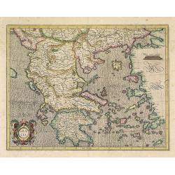
Graeciae.
Mercator's fine map of Greece, based on Nikolaus Sophianos (1500-1552).
Date: Amsterdam, 1633
Selling price: ????
Please login to see price!
Sold in 2022
Freti Magellanici ac novi Freti vulgo Le Maire exactissima delinatio..
Early impression of this fine map of Tierra del Fuego. With a Dutch translation of the explanatory text of the passage by Barent Jansz. Potgieter who accompanied captain ...
Date: Amsterdam, 1633
Selling price: ????
Please login to see price!
Sold in 2020
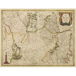
La Beauce.
A very decorative map with beautiful title cartouche of the Beauce region of France - flanked by Paris on the Seine to the north and Orleans on the Loire to the south. A ...
Date: Amsterdam, 1633
Selling price: ????
Please login to see price!
Sold in 2012
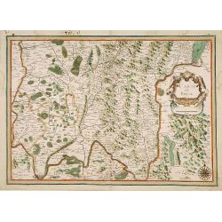
Carte de Bresse.
Map of the center of France. In lower left corner Lyon. In upper right corner Geneva. Nicolas Tassin, who was active from 1633 till 1655, was appointed 'royal cartographe...
Date: Paris, 1634
Selling price: ????
Please login to see price!
Sold
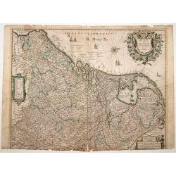
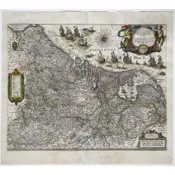
Belgii sive Germaniae Inferioris..
An extremely rare map finely engraved. According to van der Heijden, only 5 other copies are known. The map is copied by Cornelis Danckerts II after a map by Henricus Hon...
Date: Amsterdam, 1634
Selling price: ????
Please login to see price!
Sold in 2021
![Carte de Bretagne. [12].](/uploads/cache/13859-250x250.jpg)
Carte de Bretagne. [12].
"Attractive map of Bretagne. Depicts sailing vessels in the Ocean. Includes title in an ornamental cartouche on the upper left-hand corner. The atlas of the "&q...
Date: Paris 1634
Selling price: ????
Please login to see price!
Sold
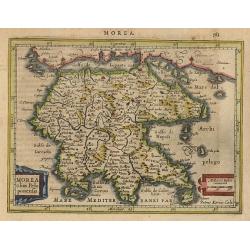
Morea olim Peloponensis.
A small map of the Peloponnesus decorated with a strapwork title cartouche. Latin text on verso.
Date: Amsterdam 1634
Selling price: ????
Please login to see price!
Sold
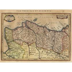
Portugallia et Algarve.
nice small map of Portugal with north oriented to the right of the map. The map is further ornamented with strapwork title and distance scale cartouches. Latin text on ve...
Date: Amsterdam 1634
Selling price: ????
Please login to see price!
Sold
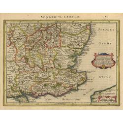
Warwicum..
Nice map of south-eastern England. Includes London, Salisbury, Oxford, Cambridge, Leicester and Norwich and the Isle of Wight. Strapwork title cartouche and scale of mile...
Date: Amsterdam 1634
Selling price: ????
Please login to see price!
Sold
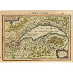
Lacus Lemannus
Handsome map of Lake Geneva with good detail of surrounding towns and villages. Decorated with 2 strapwork title cartouches. Latin text on verso.
Date: Amsterdam 1634
Selling price: ????
Please login to see price!
Sold
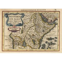
Abissinorum..
Nice map engraved by Petrus Kaerius. It depicts the kingdom of the fabled Christian king Prester John, with his fortified kingdom shown on a mountain. The Nile River eman...
Date: Amsterdam 1634
Selling price: ????
Please login to see price!
Sold
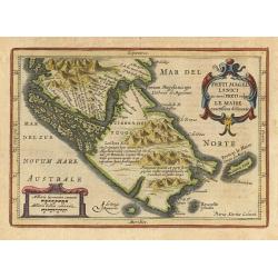
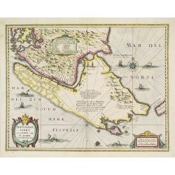
Freti Magellanici.
Decorative small map of Tierra del Feugo showing both the Strait of Magellan and the newly discovered Strait le Maire. Engraved by Petrus Kaerius. Strapwork title cartouc...
Date: Amsterdam 1634
Selling price: ????
Please login to see price!
Sold
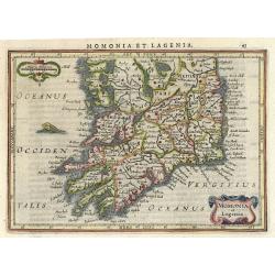
Momonia et Lagenia.
Nice map of the Southern part of Ireland. Decorated with a small strapwork title cartouche and a monster in the Ocean. Latin text on verso.
Date: Amsterdam 1634
Selling price: ????
Please login to see price!
Sold
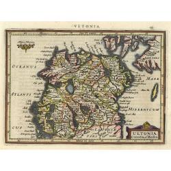
Ultonia, Conatia et Media.
This small map provides a detailed view of Northern Ireland and includes a handsome title cartouche. Latin text on verso.
Date: Amsterdam 1634
Selling price: ????
Please login to see price!
Sold
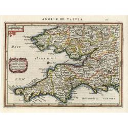
Cornubia, Devonia,..
Nice map Southwest England and South Wales. Decorated with a small strapwork title cartouche. Latin text on verso.
Date: Amsterdam 1634
Selling price: ????
Please login to see price!
Sold
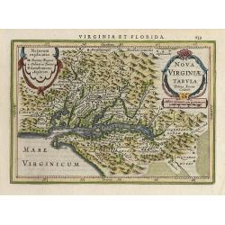
Nova Virginiae Tabula.
A decorative small version of John Smith's map of Chesapeake Bay region. It is the only regional map of North America to appear in the Atlas Minor. Engraved by Pieter van...
Date: Amsterdam 1634
Selling price: ????
Please login to see price!
Sold
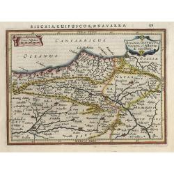
Biscaia.
Small map of the coastal Basque Country in northern Spain. The map is decorated with 2 title and distance scale cartouches. Latin text on verso.
Date: Amsterdam 1634
Selling price: ????
Please login to see price!
Sold
Gallicia.
Small map of the coast in northern Spain. The map is decorated with 2 title and distance scale cartouches. Latin text on verso.
Date: Amsterdam 1634
Selling price: ????
Please login to see price!
Sold
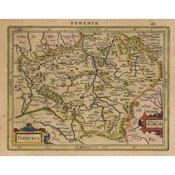
Bohemia.
Detailed map with Prague near center. Boldly engraved in Mercator's style with mountains, forests and hundreds of tiny villages. Two strapwork cartouches at bottom. Latin...
Date: Amsterdam 1634
Selling price: ????
Please login to see price!
Sold
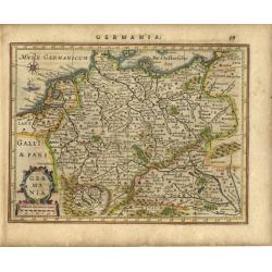
Germania.
Copper engraved map of the German empire, which stretches from Holland to Poland and from Switzerland to Hungary. Strapwork title and scale of miles cartouche with a sail...
Date: Amsterdam 1634
Selling price: ????
Please login to see price!
Sold
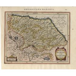
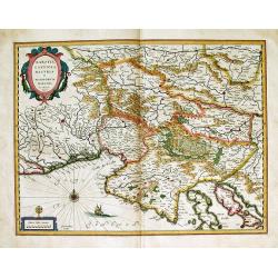
Marcha anconitana..
Map depicting a part of Italy with Ancona. Decorated with a small strapwork title cartouche. Latin text on verso.
Date: Amsterdam 1634
Selling price: ????
Please login to see price!
Sold
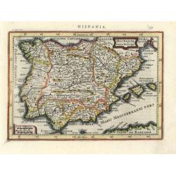
Hispania nova Descript.
Decorative small map of Spain and Portugal. Engraved by Petrus Kaerius. Small title cartouche and scale of miles. Latin text on verso.
Date: Amsterdam 1634
Selling price: ????
Please login to see price!
Sold
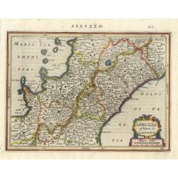
Abruzzo et Terra di Lavoro.
Nice map of a part of Italy with Napels at the left seacoast. Decorated with a small strapwork title cartouche. Latin text on verso.
Date: Amsterdam 1634
Selling price: ????
Please login to see price!
Sold
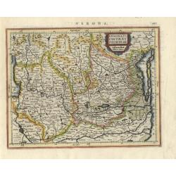
Verona, Vicentiae et Pataviae dit.
Map depicting the northern part of Italy with Lago di Garda at left and Venice at right. Decorated with a small strapwork title cartouche. Latin text on verso.
Date: Amsterdam 1634
Selling price: ????
Please login to see price!
Sold
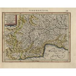
Pedemontana..
Map depicting the northern part of Italy with Monaco, Nice, Antibes, Milano and Genua. Decorated with a small strapwork title cartouche. Latin text on verso.
Date: Amsterdam 1634
Selling price: ????
Please login to see price!
Sold
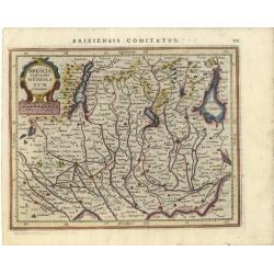
Brescia episcopatus Mediolanum Ducatus
Map depicting a part of Italy with the lakes Como and Garda and the cities Milano and Brescia. Decorated with a small strapwork title cartouche. Latin text on verso.
Date: Amsterdam 1634
Selling price: ????
Please login to see price!
Sold
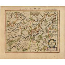
Cleve et Muers.
Map depicting a part of Germany with Coln and Cleve. Decorated with a small strapwork title cartouche. Latin text on verso.
Date: Amsterdam 1634
Selling price: ????
Please login to see price!
Sold
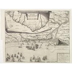
Das Norder theil des Lands Brasilien.
The map, displayed on a roll above, shows the coastal contours, with place-names along the Brazilian coast near Recife, and below is a bird?s-eye view of the siege with s...
Date: Frankfurt 1633-1634
Selling price: ????
Please login to see price!
Sold
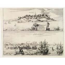
\"Olinda\" and \"Olinda de Phernambuco\".
Above, this shows a view of the town of Olinda, with two figures in the foreground displaying a cloth on which are displayed fourteen places by name. Below an offshore vi...
Date: Frankfurt 1633-1634
Selling price: ????
Please login to see price!
Sold
Tabula Geographica vnova omnium oculis exibens et proponens venssimam descriptionem..
De Bry's important map of the Orinoco Basin and El Dorado, including Venezuela and Guiana. The islands of Aruba, Curaçao, Bonaire, etc in upper left corner.The map inclu...
Date: Frankfurt 1633-1634
Selling price: ????
Please login to see price!
Sold
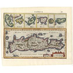
Candia
Map of the island with smaller inset maps above: Corfu, Zante, Milo, Nicsia, and Scarpanto. Strapwork title cartouche and Latin text on verso.
Date: Amsterdam 1634
Selling price: ????
Please login to see price!
Sold
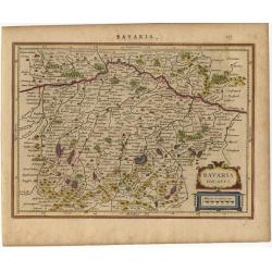
Bavaria Ducatus.
Map depicting a part of Germany. Decorated with a small strapwork title cartouche. Latin text on verso.
Date: Amsterdam 1634
Selling price: ????
Please login to see price!
Sold
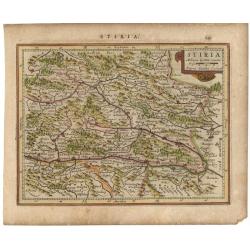
Stiria
Map depicting a part of Austria with Graz in the middle. Decorated with a small strapwork title cartouche. Latin text on verso.
Date: Amsterdam 1634
Selling price: ????
Please login to see price!
Sold
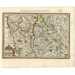
Lotharingia Septentrional.
Detailed map of the North/east part of France. Decorated with a small strapwork title cartouche. Latin text on verso.
Date: Amsterdam 1634
Selling price: ????
Please login to see price!
Sold
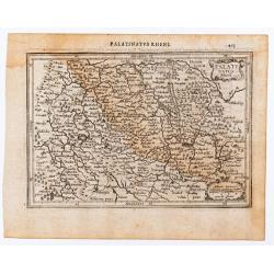
Palatinatus Rheni.
Map depicting a part of Germany with Heidelberg. Decorated with a small strapwork title cartouche. Latin text on verso.
Date: Amsterdam 1634
Selling price: ????
Please login to see price!
Sold
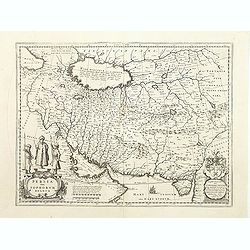
Persia Sive Sophorum Regnum.
A finely designed map of the region stretching from the Caucasus trough Afghanistan an the Arabian Desert to the Indus River from the great Blaeu family of Amsterdam. Wit...
Date: Amsterdam, 1634
Selling price: ????
Please login to see price!
Sold
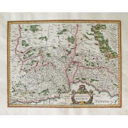
BAVARIA DUCATUS.
Beautiful map of Bavaria, based on Mercator's earlier map of this region.Willem Janszoon, or Willem Jansz Blaeu (1571-1638) as he is more commonly known, was one of the m...
Date: Amsterdam, 1634
Selling price: ????
Please login to see price!
Sold in 2013
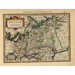
Russia cum Confinijs.
Charming small map of European Russia. Nicely detailed including engraved forests and mountains and embellished with two strapwork cartouches. Latin text on verso.
Date: Amsterdam 1634
Selling price: ????
Please login to see price!
Sold
Hildesheim: Episcopatus HILDESIENSIS Descriptio ...
Highly attractive map. First appearance in an atlas of Blaeu's folio map of Hildesheim, Hartz Mountains, etc. with numerous attractive elements. Willem Janszoon, or Wil...
Date: Amsterdam, 1634
Selling price: ????
Please login to see price!
Sold in 2013
STIRIA Steymarck. . .
The First Appearance of this map of Steiermark in Austria in Blaeu's atlas. Willem Janszoon, or Willem Jansz Blaeu (1571-1638) as he is more commonly known, was one of th...
Date: Amsterdam, 1634
Selling price: ????
Please login to see price!
Sold in 2014
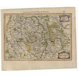
PALATINATUS AD RHENUM
Attractive map of the Rheinpfalz and the lower Rhine, with the Rhine River running top to bottom through the center of the map, shows major cities such as Heidelberg, wit...
Date: Amsterdam, 1634
Selling price: ????
Please login to see price!
Sold in 2013
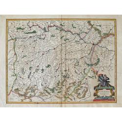
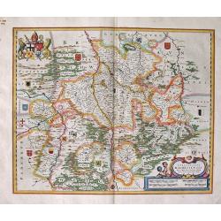
Alemannia Sive Sueuia Superior. . .
Highly detailed map of the region of upper Swabia centered on Ulm. Willem Janszoon, or Willem Jansz Blaeu (1571-1638) as he is more commonly known, was one of the most ...
Date: Amsterdam, 1634
Selling price: ????
Please login to see price!
Sold in 2014
Islandia
Delightful small map of Iceland, which is shown filled with mountains and volcanoes. Strapwork title and distance scale cartouche. Latin text on verso.
Date: Amsterdam, 1634
Selling price: ????
Please login to see price!
Sold
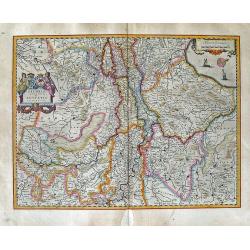
Tractus Danubii, Fluminis in Europa Maximi, A Fontibus, Per Germaniam...
This is Blaeu’s first map of the Danube and surrounding regions. The Danube River runs through the map from the top left with its headwaters in the German Black Forest...
Date: Amsterdam, 1634
Selling price: ????
Please login to see price!
Sold in 2011
Quarta pars Brabantiae cujus caput Sylvaducis. . .
This is a rare first state of Blaeu's map of Brabant (north). This marvelous map is only found in the relatively scarce Novus Atlas by Willem Blaeu, published in Amsterd...
Date: Amsterdam, 1634
Selling price: ????
Please login to see price!
Sold in 2012
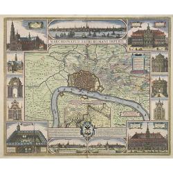
Marchionatus Sacri Romani Imperii. Nobilissimo,. . . Dedicat, consecrat, Nicolaus Janssonius Piscator. C. J. Visscher Excudebat. Anno. 1624. From the atlas by Kaerius.
Beautiful and decorative town-plan of Antwerp with its surroundings. Three panoramic city views of Antwerp and ten vignette views of remarkable buildings, together with a...
Date: Amsterdam, 1634
Selling price: ????
Please login to see price!
Sold in 2012
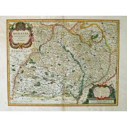
Mora Via.
Displays the Moravia region of the Czech Republic in extraordinary detail. Represented are mountain regions, forests, and rivers. Towns are highlighted by red markers and...
Date: Amsterdam, 1634
Selling price: ????
Please login to see price!
Sold in 2010
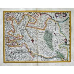
Geldria Ducatus et Zutfania Comitatus.
A highly decorative and detailed map of the Gelderland and Zutphen in The Netherlands. This is variant "B" of the map with the right coat of arms above the tit...
Date: Amsterdam, (1631) 1634
Selling price: ????
Please login to see price!
Sold in 2011
AGER PARISIENSIS Vulgo L'ISLE DE FRANCE ... / Apud Guiljelmum Blaeu.
This is the first appearance of Blaeu’s map of Paris and its surrounding region; from Blaeu's atlas of 1634. Paris is shown toward the bottom center of the map with th...
Date: Amsterdam, 1634
Selling price: ????
Please login to see price!
Sold in 2012
Tractus RHENI et MOSAE totusque VAHALIS ... Exc Guiljel Blaeuw.
A highly attractive map. The two maps depict the area around the Rhine, Waal, and Meuse Rivers in The Netherlands. Shows all the villages, fortresses, cities and castl...
Date: Amsterdam, (1630) 1634
Selling price: ????
Please login to see price!
Sold in 2011
Palatinus Rheni.
Single page map of the region surrounding Mannheim. Several old light pencil annotations. Latin text on verso.
Date: Amsterdam, J.Janssonius, 1628-1634
Selling price: ????
Please login to see price!
Sold in 2020
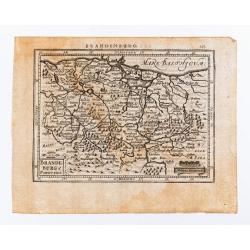
Brandeburg et Pomerania.
Single page map of north eastern Germany.
Date: Amsterdam, J.Janssonius, 1628-1634
Selling price: ????
Please login to see price!
Sold in 2023
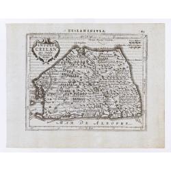
Insula Ceilan quae incolis Tenarisin dicitur.
Single page map of Sri Lanka. Latin text on verso.
Date: Amsterdam, J.Janssonius, 1628-1634
Selling price: ????
Please login to see price!
Sold in 2020
Novus XVII Inferioris Germaniae Provinciarum Typus
One of the most decorative maps of the Benelux countries. Title in a cartouche with Mercury and Mars at top right, with dedication and the name of 'Guliel. Blaeu'. Bottom...
Date: Amsterdam, 1630/1634
Selling price: ????
Please login to see price!
Sold in 2022
WALACHIA SERBIA BULGARIA ROMANIA ... Guiljelmus Blaeu excudebat.
A highly decorative, well-prepared map of southeast Europe. This map, from the 1634 German edition of the Blaeu atlas, is its first appearance in an atlas. Willem Janszo...
Date: Amsterdam, 1634
Selling price: ????
Please login to see price!
Sold in 2012
TRANSYLVANIA Sibenburgen ... Apud Guiljelmum et Ioannem Blaeu.
A highly decorative, well-prepared map of Transylvania in southeast Europe. This particular map, from the 1634 German edition of the Blaeu atlas, is its first appearance ...
Date: Amsterdam, 1634
Selling price: ????
Please login to see price!
Sold in 2012
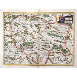
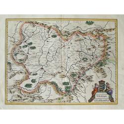
MORAVIA MARCHIONATUS Auctore I.A. Comenio.
A decorative map that shows the eastern part of the Czech Republic with Poland to the north. It is a finely detailed map with numerous placenames throughout.
Date: Amsterdam, (1629) 1634
Selling price: ????
Please login to see price!
Sold in 2012
KARSTIA CARNIOLA HISTRIA et WINDORVM MARCHIA Ger. Mercatore Auctore. Guiljel Blaeu excudit.
This is a decorative map of the area showing the area around Triest, a city and seaport in northeastern Italy. It is situated towards the end of a narrow strip of land ly...
Date: Amsterdam, 1634
Selling price: ????
Please login to see price!
Sold in 2012
ULTRAIECTUM DOMINIUM Excudit Guiljelmus Blaeu.
A highly detailed map of Utrecht and its surroundings of The Netherlands. From a German edition of Blaeu's atlas.
Date: Amsterdam, 1634
Selling price: ????
Please login to see price!
Sold in 2012
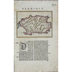
SARDINIA.
This is the first appearance of this Blaeu map. It is without the title cartouche and is on a page of text. Willem Janszoon, or Willem Jansz Blaeu (1571-1638) as he is m...
Date: Amsterdam, 1634
Selling price: ????
Please login to see price!
Sold in 2012
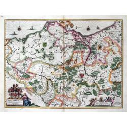
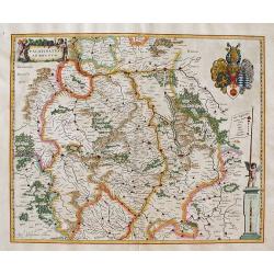
Brandenburg, Pommern, Mecklenburg, with Berlin : BRANDEBURGUM MARCHIONATUS Ducatibus Pomeraniae et Mekelenburg. Amsterdami Apud Guiljelmum et Ioannem Blaeu.
Highly attractive and detailed map of Brandenburg, Pommern, Mecklenburg, with Berlin.The example we have is from the early 1634 German edition of Willem Blaeu's Novus Atl...
Date: Amsterdam, 1634
Selling price: ????
Please login to see price!
Sold in 2012
Leodiensis Dioecesis.
This is a rare proof state of Blaeu's map of Leige. It is only known in the relatively scarce Novus Atlas by Willem Blaeu, published in Amsterdam in 1634-1635. The proo...
Date: Amsterdam, 1634
Selling price: ????
Please login to see price!
Sold in 2012
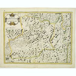
Carte d'Auvergne.
Map of Auvergne. Beautiful title cartouche affecting the form of a sea monster. Nicolas Tassin, who was active from 1633 till 1655, was appointed 'royal cartographer' at ...
Date: Paris, 1634
Selling price: ????
Please login to see price!
Sold
PALATINATUS BAVARIA.
Attractively colored map of the Oberpfalz, showing a large section of southwestern Germany. The Palatinate, historically also Rhenish Palatinate, and at one time in union...
Date: Amsterdam, 1634
Selling price: ????
Please login to see price!
Sold in 2014
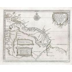
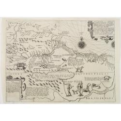
Die Landschafft Gvaiana Inhaltende alle die Prouincien awischen dem Fluss AMAZONVM und dem wasser YVIAPARI oder ORINOQVE
This map appeared in the "Historia antipodvm sive Novi Orbis, qvi vvlgo Americae et Indiae Occidentalis. . ., edited by J.L. Gottfried and published by Matthas Meria...
Date: Frankfurt, M. Merian, 1633-1634
Selling price: ????
Please login to see price!
Sold in 2018
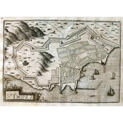
St Tropez.
Early view of St. Tropez showing the fortifications. The harbour with several sailing ships. Published by Nicolas Tassin in "Les Plans et Profilz de toutes principal...
Date: Paris, c1634
Selling price: ????
Please login to see price!
Sold in 2013
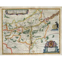
NAMURCUM COMITATUS Auctore Iohann Surhino.
This is Blaeu’s highly decorative map of the region of Namur in Belgium. Willem Janszoon, or Willem Jansz Blaeu (1571-1638) as he is more commonly known, was one of t...
Date: Amsterdam, 1634
Selling price: ????
Please login to see price!
Sold in 2014