Browse Listings

Dôme de Nikolskoï dans le Gastinnoï-dwor, (Grand Bazar).
A view of the Dome of Nikolskoï. Figures are lithographed by Raffet. Plate taken from the first illustrated account of Russian architecture. This publication was the pro...
Date: Paris, 1844
Selling price: ????
Please login to see price!
Sold in 2019

Cathédrale de la Nativite.
A view of the Nativité Cathedral. Figures are lithographed by Raffet. Plate was taken from the first illustrated account of Russian architecture. This publication was th...
Date: Paris, 1844
Selling price: ????
Please login to see price!
Sold in 2022
![[Title page] Voyage pittoresque et archaéologique en Russie.](/uploads/cache/41442-250x250.jpg)
[Title page] Voyage pittoresque et archaéologique en Russie.
Title page of "Voyage pittoresque et archaéologique en Russie" with two joined pages. The first is a letter for a certain "Mathilde" from Anatole Dé...
Date: Paris, 1844
Selling price: ????
Please login to see price!
Sold in 2018

Monastère de Saint-Jean-Baptiste.
A view of Saint-Jean-Baptiste monastery, the 15 of September 1839. Figures are lithographed by Raffet. Plate taken from the first illustrated account of Russian architect...
Date: Paris, 1844
Selling price: ????
Please login to see price!
Sold
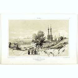
Vue de Nijni-Novgorod et du Monastère de l'annonciation.
A view of Nijni-Novgorod village, the 2 of September 1839. Figures are lithographed by Raffet. Plate taken from the first illustrated account of Russian architecture. Thi...
Date: Paris, 1844
Selling price: ????
Please login to see price!
Sold in 2019

Chappelle et village de Tver.
A view of Tver village. Figures are lithographed by Raffet. Plate taken from the first illustrated account of Russian architecture. This publication was the project of Co...
Date: Paris, 1844
Selling price: ????
Please login to see price!
Sold in 2019
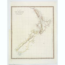
The Islands of New Zealand.
This is a map of New Zealand produced by the Society for the Diffusion of Useful Knowledge (S.D.U.K.). It covers the entire island country from Cape Reinga (C. Maria Van ...
Date: London, ca. 1844
Selling price: ????
Please login to see price!
Sold in 2019

HOTEL DE BOURG-THEROULDE A ROUEN. Dessiné d'après nature par Chapuy. Lith. par Rouargue.
Original lithograph of De Bourg-Theroulde Hotel, situated in Rouen. Lithographed by Rouargue after a design by Chapuy and printed in Paris by Lemercier, Bernard Cie.
Date: Paris, 1844
Selling price: ????
Please login to see price!
Sold in 2019
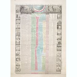
Tableau historique et chronologique du Royaume de Belgique ainsi que du Royaume Neerlandais depuis la plus haute antiquité jusqu'à nos jours
According to the text below, an "Nouvelle edition" of the decorative sheet giving a historical overview of the history of Belgium and events in the Netherlands.
Date: Paris, 1845
Selling price: ????
Please login to see price!
Sold in 2014
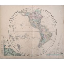
Western Hemisphere & Eastern Hemisphere.
Two steel engraved maps with original coloring and centerfold as issued. They are from The Edinburgh Imperial Atlas, published in Edinburgh by Gall & Inglis, 1859. Th...
Date: Edinburgh, 1845
Selling price: ????
Please login to see price!
Sold in 2013
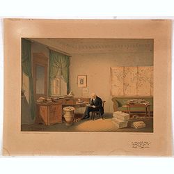
(Alexander von Humboldt in his study)
This rare and charming lithography of Alexander von Humboldt (1769-1859) in his study was made after a water color of his close friend E. Hildebrandt. Printed facsimile c...
Date: Berlin, A. Duncker, 1845
Selling price: ????
Please login to see price!
Sold in 2015
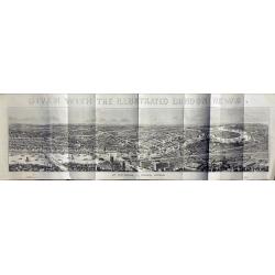
View of London.
Very large wood engraving printed and published as a supplement for the Illustrated London News, by William Little, London, January 11, 1845.
Date: London, 1845
Selling price: ????
Please login to see price!
Sold in 2014
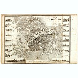
Plan von St. Petersburg.
Detailed plan of St. Petersburg features engraved vignettes of buildings throughout the great city, including a hospital, theater, library, bank, and churches. The title ...
Date: Hildburghausen, 1845
Selling price: ????
Please login to see price!
Sold in 2015

Bewohner der Insel Timor, Habitans de L'Isle Timor.
Four hand colored pictures on one print of inhabitants of the Island of Timor. From "NATIVE PEOPLE OF THE WORLD" by Heinrich Rudolf Schinz in Zurich, Switzerlan...
Date: Zürich, 1845
Selling price: ????
Please login to see price!
Sold in 2017

Mandan Chef. / Chef Mandan.
Original lithograph by J. Honegger, after an aquarell by Karl Bodmer, for Maximilian Prinz zu Wied's': "Reise in das innere Nord-America in den Jahren 1832 bis 1834&...
Date: Zurich, 1845
Selling price: ????
Please login to see price!
Sold in 2015

Dacota-Krieger./ Guerrier Dacota.
Original lithograph by J. Honegger, after an aquarell by Karl Bodmer, for Maximilian Prinz zu Wied's's: “Reise in das innere Nord-America in den Jahren 1832 bis 1834”...
Date: Zurich, 1845
Selling price: ????
Please login to see price!
Sold in 2015

Fazenda du Secretario.. .Manicipe de Vassouras.
Scare lithograph of Fazenda du Secretario. Lithographed by Jacottet. After a photograph of Victor Frond.
Date: Paris, ca. 1845
Selling price: ????
Please login to see price!
Sold in 2015

Fazenda du Secretario Manicipe de Vassouras.
Scare lithograph of Fazenda du Secretario. Lithographed by Jacottet. After a photograph of Victor Frond.
Date: Paris, 1845
Selling price: ????
Please login to see price!
Sold in 2015
Atlas classique et universel de Géographique ancienne et moderne contenant les decouvertes et les divisions les plus nouvelles.
Important atlas complete with 30 large engraved maps on 31 sheets (Switzerland on two sheets).The highly detailed maps are:1) Monde ancien 2) Palestine 3) Grece ancienne ...
Date: Paris, 1845
Selling price: ????
Please login to see price!
Sold in 2016
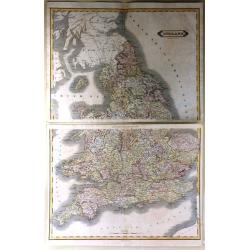
England
A very large map of England and Wales, focusing on the railway network constructed by W. H. Lizars from the most recent surveys, published by Lizars in Edinburgh in 1848....
Date: Edinburgh, 1845
Selling price: ????
Please login to see price!
Sold in 2016
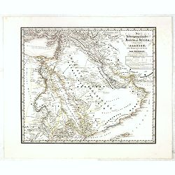
Die übergangsländer von Asien und Afrika begreifend : Arabien nebst Mesopotamien und Syrien und das Nilgebiet. . .
This extremely rare separately-issued map of the Middle East was made as a private commission by a group of Münich grandees led by Gotthilf Heinrich von Schubert (1780 -...
Date: Munich, 1845
Selling price: ????
Please login to see price!
Sold
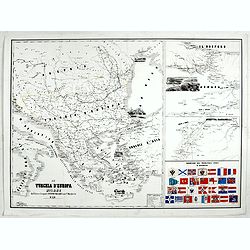
La Turchia d'Europa Milano dall'Editore Lithografo Antonio Vallardi. . .
Three maps on one sheet: to the left map of present Greece, with European part of Turkey, Marmara Sea and the west coast of Turkey. In the Black Sea a small panoramic vie...
Date: Milan, ca. 1845
Selling price: ????
Please login to see price!
Sold in 2017
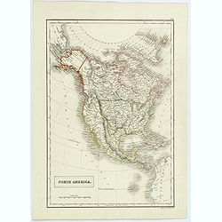
North America.
Sidney Hall's map of North America, showing Texas as a republic. Other interesting facts are that Alaska is still Russian Territory, Canada stretches down 'Western Territ...
Date: London, ca 1845
Selling price: ????
Please login to see price!
Sold in 2020
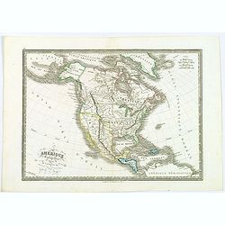
Amérique septentrionale.
An uncommon map of North America prepared by N.Lorrain, who worked for Dépot de la Guerre. Showing the state of Texas as a republic. Mexico occupied the south west, and ...
Date: Paris, 1845
Selling price: ????
Please login to see price!
Sold in 2020
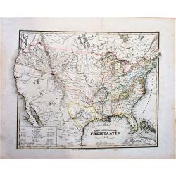
Nord-Americanische Freistaaten (shows Republic of Texas).
An attractive map of the United States just prior to the Mexican-American War. It shows a small Republic of Texas with its southwestern border on the Nueces River. The na...
Date: Hildburghausen, 1845
Selling price: ????
Please login to see price!
Sold in 2018
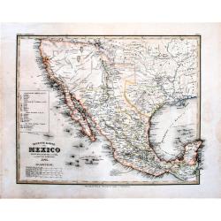
Neueste Karte von Mexico Nach den Besten Quellen . . . (shows Republic of Texas)
The Republic of Texas was a sovereign state from 1836 to 1845. It claimed a region including all of the present state of Texas, together with parts of present-day New Mex...
Date: Hildburghausen, 1845
Selling price: ????
Please login to see price!
Sold in 2018
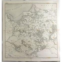
Carte du Pays Compris Entre la Vistule et la Pregel.
A map of Polish regions, including Warsaw, part of Russia and Danzig Bay, prepared by Dufour, and engraved by Ch. Dyonnet. It features the prominent cities of Gdansk (wri...
Date: Paris, 1845
Selling price: ????
Please login to see price!
Sold in 2019
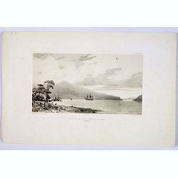
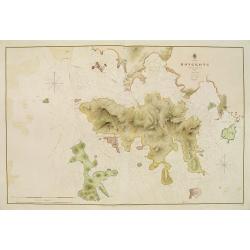
Fond de la Baie Sarah's Bosom (Iles Aukland)
On 11 March 1840 Jules Dumont d’Urville, commanding the French ship Astrolabe, sailed from Hobart to the sub Antarctic Auckland Islands. This sweeping view is of the ba...
Date: Paris, ca 1845
Selling price: ????
Please login to see price!
Sold in 2019
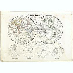
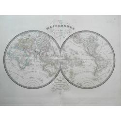
Mappemonde.
Detailed double hemisphere world map, prepared by Charles V. Monin (fl.1830-1880) a French cartographer of Caen and Paris. Published in Atlas Universel de Géographie Anc...
Date: Paris, 1845
Selling price: ????
Please login to see price!
Sold in 2023
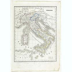
Italie.
Detailed map of Italy, prepared by Charles V. Monin (fl.1830-1880) a French cartographer of Caen and Paris. Published in Atlas Universel de Géographie Ancienne &c Mo...
Date: Paris, 1845
Selling price: ????
Please login to see price!
Sold in 2023
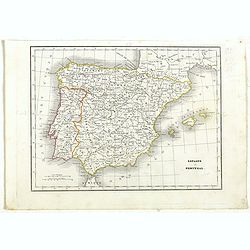
Espagne et Portugal.
Detailed map of Spain and Portugal, prepared by Charles V. Monin (fl.1830-1880) a French cartographer of Caen and Paris. Published in Atlas Universel de Géographie Ancie...
Date: Paris, 1845
Selling price: ????
Please login to see price!
Sold in 2019
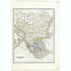
Turquie d'Europe.
Detailed map of European Turkey, including Greece, Romania, Bulgaria, Bosnie, etc. Prepared by Charles V. Monin (fl.1830-1880) a French cartographer of Caen and Paris. Pu...
Date: Paris, 1845
Selling price: ????
Please login to see price!
Sold in 2019
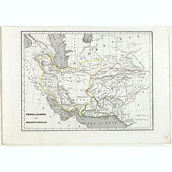
Perse, Kaboul et Beloutchistan.
Detailed map of Persia, Kabul and Baluchistan, prepared by Charles V. Monin (fl.1830-1880) a French cartographer of Caen and Paris. Published in Atlas Universel de Géogr...
Date: Paris, 1845
Selling price: ????
Please login to see price!
Sold in 2024
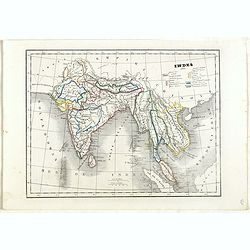
Indes.
Detailed map of India, Malaysia, Cambodia, Tibet and Thailand, prepared by Charles V. Monin (fl.1830-1880) a French cartographer of Caen and Paris. Published in Atlas Uni...
Date: Paris, 1845
Selling price: ????
Please login to see price!
Sold in 2024
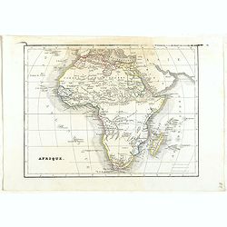
Afrique.
Detailed map of Africa, prepared by Charles V. Monin (fl.1830-1880) a French cartographer of Caen and Paris. Published in Atlas Universel de Géographie Ancienne &c M...
Date: Paris, 1845
Selling price: ????
Please login to see price!
Sold in 2022
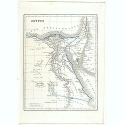
Egypte.
Detailed map of Egypt, prepared by Charles V. Monin (fl.1830-1880) a French cartographer of Caen and Paris. Published in Atlas Universel de Géographie Ancienne &c Mo...
Date: Paris, 1845
Selling price: ????
Please login to see price!
Sold in 2022
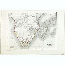
Afrique Meridionale.
Detailed map of the Southern part of Africa, including Madagascar and close islands, prepared by Charles V. Monin (fl.1830-1880) a French cartographer of Caen and Paris. ...
Date: Paris, 1845
Selling price: ????
Please login to see price!
Sold in 2022
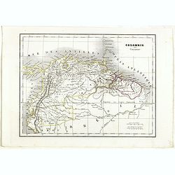
Colombie et Guyanne.
Detailed map of Colombia and Guyana / Surinam, prepared by Charles V. Monin (fl.1830-1880) a French cartographer of Caen and Paris. Published in Atlas Universel de Géogr...
Date: Paris, 1845
Selling price: ????
Please login to see price!
Sold in 2019
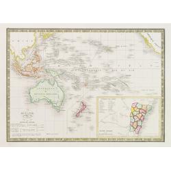
Océanie.
Detailed map of the Pacific with Australia, New Zealand, Indonesia and California. Lower right inset map of the south east coast of Australia Colonie Anglaise de la Nouve...
Date: Paris 1845
Selling price: ????
Please login to see price!
Sold
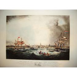
"This View of the Port of Liverpool..."
A large and impressive prospect of the city of Liverpool as seen from the port viewpoint. The ?active? nautical scene showing vessels in turbulent waters originates from ...
Date: Liverpool, ca. 1845
Selling price: ????
Please login to see price!
Sold
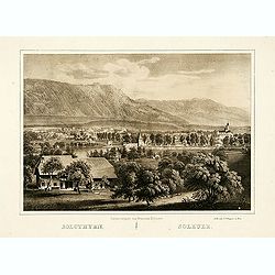
Solothurn.
"The lithography is made after a Daguerreotype by Franziska Möllinger. Lithographed by J. P. Wagner."
Date: Bern, 1845
Selling price: ????
Please login to see price!
Sold
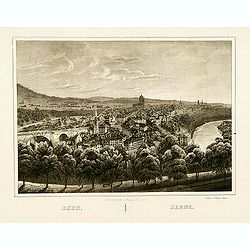
Bern.
The lithography is made after a Daguerreotype by Franziska Möllinger. Lithographed by J. P. Wagner.
Date: Bern, 1845
Selling price: ????
Please login to see price!
Sold in 2013
18 plates taken from <I>Rio de Janeiro Pitoresco.</I>
Group of 18 very rare lithographes made Heaton e Rensburg active in Rio de Janeiro. Edited by L. Buvelot after design of Auguste Moreau. Originating from RIO DE JANEIRO P...
Date: Rio de Janeiro 1845
Selling price: ????
Please login to see price!
Sold
HONG KONG surveyed by Captn. Sir Edward Belcher, in H.M.S. Sulphur 1841. Corrected to 1845.
Nautical chart of Hong Kong. Engraved by J. & C. Walker, it is based on the observations of Sir Edward Belcher, a British naval officer and explorer.Belcher entered t...
Date: London 1841 - 1845
Selling price: ????
Please login to see price!
Sold
Texas.
Rare map of Texas by Flemming. With counties outlined in color and an inset map of Galveston Bay.
Date: Glogau 1841 - 1845
Selling price: ????
Please login to see price!
Sold
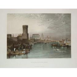
Cologne from the River.
An uncommon, nicely defined steel-plate view of Cologne as seen in the early-to-mid 1800s. The city's famous cathedral is shown. The river scene includes commercial barge...
Date: New York, ca. 1845
Selling price: ????
Please login to see price!
Sold in 2011
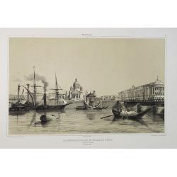
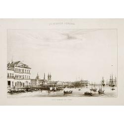
Cathédrale d'Isaac et Palais du Sénat. Vue prise de la Néva. (17 juillet 1839).
A view from the port of the Isaac Cathedral and the Senat Palace in Saint Petersburg on July 17 1839. Plate taken from the first illustrated account of Russian architectu...
Date: Paris, 1845
Selling price: ????
Please login to see price!
Sold in 2025
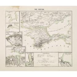
Die Krymm.
Uncommon map of Crimea and the area south of the Dnieper. Surrounded by six detailed inset plans of harbor towns (Sevastopol, Balaklava, Feodosia, etc) and a scale.
Date: Glogau, 1845
Selling price: ????
Please login to see price!
Sold in 2010
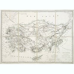
Asie mineure ou Natolie selon l'état actuel des connaissances. . .
Map of Turkey, including Cyprus prepared by Louis Vivien de Saint-Martin (1802-1897), who was French geographer born in Saint-Martin-de-Fontenay and died in Paris. He wro...
Date: Paris, 1845
Selling price: ????
Please login to see price!
Sold in 2021
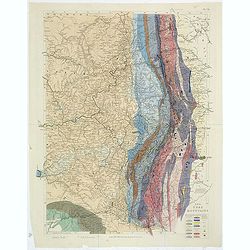
The Ural Mountains. Pl.VII.
A soil map of the Ural Mountains, with a color key in lower right corner. With very delicate original hand coloring.
Date: London,1845
Selling price: ????
Please login to see price!
Sold in 2011
Karte des Euler Bezirkes im Prager Kreise zusammengestellt nach den neuesten und verlässchsten Quellen. . . / Mapa Okresu Jilovského v Prazskem kraji. . .
Uncommon folding map of Jilovského region. Printed in color lithography by J.Habel in Prague. Lithographed by J.Wagner. Decorative inset upper right of the Ringhoffer Ku...
Date: Prague, J.Habel, c 1845
Selling price: ????
Please login to see price!
Sold in 2013
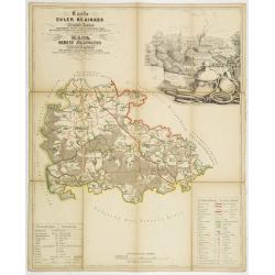
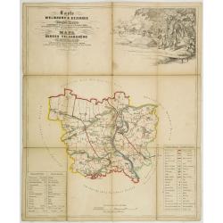
Karte des Pürglitzer bezirkes im Prager- Kreise. . . / Mapa Okresu Krivoklatského v Prazkém kraji. . .
Uncommon folding map of Krivoklatského region. Printed in color lithography by J.Habel in Prague. Lithographed by Jan Ed. Wagner. Decorative inset upper right with a ret...
Date: Prague, J.Habel, c 1845
Selling price: ????
Please login to see price!
Sold in 2011
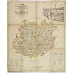
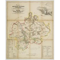
Karte des Welwarner Bezirkes im Prager Kreise zusammengestellt nach den neuesten und verlässchsten Quellen. . . / Mapa Okresu Velvarského v Prazskem kraji. . .
Uncommon folding map of Velvarského region. Printed in color lithography by J.Habel in Prague. Lithographed by J.Wagner. Decorative inset upper right of people harvestin...
Date: Prague, J.Habel, c 1845
Selling price: ????
Please login to see price!
Sold in 2011
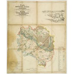
Karte des Brandeiser Bezirkes im Prager Kreise zusammengestellt nach den neuesten und verlässchsten Quellen. . . / Mapa Okresu Brandýského v Prazskem kraji. . .
Uncommon folding map of Brandýského region. Printed in color lithography by J.Habel in Prague. Lithographed by J.Wagner. Decorative landscape upper right and key in low...
Date: Prague, J.Habel, c 1845
Selling price: ????
Please login to see price!
Sold in 2013
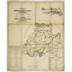
Karte des Böhmisch-Broder bezirkes im Prager- Kreise. . . / Mapa Okresu Cesko-Brodského v Prazkém kraji. . .
Uncommon folding map of Brodského region. Printed in color lithography by J.Habel in Prague. Lithographed by J.E.Wagner. Decorative landscape upper left with a hunting s...
Date: Prague, J.Habel, c 1845
Selling price: ????
Please login to see price!
Sold in 2011
Karte des Melniker bezirkes im Prager- Kreise. . . / Mapa Okresu Mélnického v Prazkém kraji. . .
Uncommon folding map of Mélnického region with the rivers Moldova and the Elbe at Melník. Printed in color lithography by J.Habel in Prague. Lithographed by Jan Ed. Wa...
Date: Prague, J.Habel, c 1845
Selling price: ????
Please login to see price!
Sold in 2011
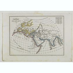
Monde connu des anciens.
Detailed map of Europe, Russia, Arabia and part of Africa, prepared by Charles V. Monin (fl.1830-1880) a French cartographer of Caen and Paris. Published in Atlas Univers...
Date: Paris, 1845
Selling price: ????
Please login to see price!
Sold in 2023
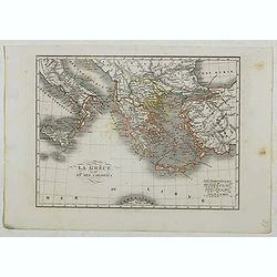
La Grèce et ses colonies.
Detailed map of Greece, prepared by Charles V. Monin (fl.1830-1880) a French cartographer of Caen and Paris. Published in Atlas Universel de Géographie Ancienne &c M...
Date: Paris, 1845
Selling price: ????
Please login to see price!
Sold in 2020
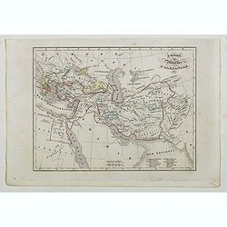
Empire et Marches D'Alexandrie.
Detailed map of Egypt, part of Arabia, prepared by Charles V. Monin (fl.1830-1880) a French cartographer of Caen and Paris. Published in Atlas Universel de Géographie An...
Date: Paris, 1845
Selling price: ????
Please login to see price!
Sold in 2023
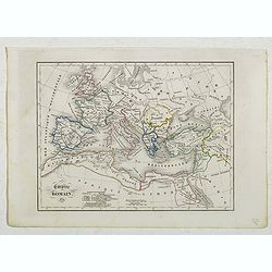
Empire Romain.
Detailed map of Europe and North Africa, prepared by Charles V. Monin (fl.1830-1880) a French cartographer of Caen and Paris. Published in Atlas Universel de Géographie ...
Date: Paris, 1845
Selling price: ????
Please login to see price!
Sold in 2022
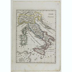
Italie Ancienne.
Detailed map of Italy, prepared by Charles V. Monin (fl.1830-1880) a French cartographer of Caen and Paris. Published in Atlas Universel de Géographie Ancienne &c Mo...
Date: Paris, 1845
Selling price: ????
Please login to see price!
Sold in 2022
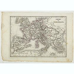
Empire de Charlemagne.
Detailed map of Europe, prepared by Charles V. Monin (fl.1830-1880) a French cartographer of Caen and Paris. Published in Atlas Universel de Géographie Ancienne &c M...
Date: Paris, 1845
Selling price: ????
Please login to see price!
Sold in 2022

London in Miniature With The Surrounding Villages. An Entire New Plan In which the Improvements both present and intended are actually reduced (by permission) from the surveys of the Several Proprietors ...
Folding plan of London showing the extents from Islington through to Camberwell and the River Lea to Kensington. Bright original color in block and outline. The plan diss...
Date: London: Edward Mogg, No. 14 Great Russell Street. January 1st, 1845
Selling price: ????
Please login to see price!
Sold in 2020
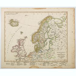
Schweden und Norwegen, Danemark, Island u. Faer-Oer. . .
A map of the northern Atlantic Ocean, centered on Scandinavia, the British Isles and Iceland published by Stieler in his 'Hand-Atlas.' Scandinavian region are listed belo...
Date: Gotha, 1845
Selling price: ????
Please login to see price!
Sold in 2021
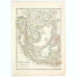
Eastern Islands Birmah &c.
A detailed early-Victorian map of south east Asia, from 'Black's General Atlas.' The map covers parts of modern day Burma (Myanmar) Thailand, Malaysia, Cambodia, Vietnam,...
Date: London, 1845
Selling price: ????
Please login to see price!
Sold in 2020
![[Fortifications de Paris.]](/uploads/cache/48146-250x250.jpg)
[Fortifications de Paris.]
A lovely quite detailed plan of Paris published towards the middle of the 19th century. The plan identifies the various fortifications that surrounded the city. They are ...
Date: Paris, ca 1845
Selling price: ????
Please login to see price!
Sold in 2022
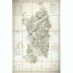
Carta dell isola e regno di Sardegna.
Considered the first map of Sardinia according to modern geodesic methods, it was realized thanks to the work of Alberto Ferrero della Marmora, later assisted by Majo...
Date: Paris and Torino, 1845
Selling price: ????
Please login to see price!
Sold in 2022
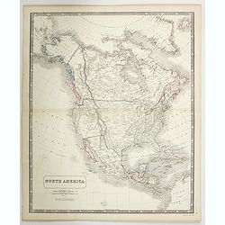
North America.
A detailed map of North America by William and Alexander Keith Johnston, a well-known publisher of maps who continually updated his maps. From his National Atlas of Geogr...
Date: Edinburgh, ca 1845
Selling price: ????
Please login to see price!
Sold in 2023

Atlante di Geografia Storica universale. Raccolta di tavole, cronologiche, geografiche, etnografiche e monumentali appositamente disegnate…
This uncommon and decorative atlas contains 52 maps in original outline colors and is followed by 60 ethnographic plates, of which the first 30 are colored in full origin...
Date: Firenze: Vincenzo Batelli e Compagni, 1845
Selling price: ????
Please login to see price!
Sold in 2024
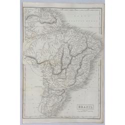
Brazil.
A detailed map of Brazil in South America from Adam & Charles Black, who were among the leading publishers of atlases and travel books in the 19th Century in England....
Date: London, 1846
Selling price: ????
Please login to see price!
Sold in 2021
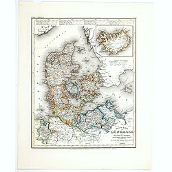
Neueste Karte von Danemark mit Holstein und Lauenburg. . .
A detailed regional map of Denmark, with inset map of the Danish dependency of Iceland. Administrative boundaries hand col. Relief shown by hachures. From Meyer's Hand At...
Date: Hildburghausen, 1846
Selling price: ????
Please login to see price!
Sold in 2021
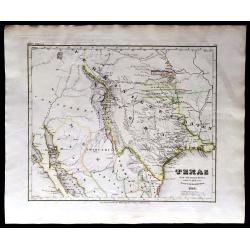
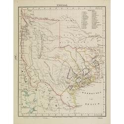
Texas, 1846.
RARE! The first year Texas as a state. A large lithographic map showing the state of Texas, with county boundaries, in original hand coloring. It shows the brand new stat...
Date: Leipzig, 1846
Selling price: ????
Please login to see price!
Sold in 2020
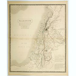
Palestine.
A large detailed map of the Holy Land, in fact, one of the largest maps of of this region to appear in a mid-19th century. Shows many towns, roads, rivers, mountains, lak...
Date: Edinburgh, 1846
Selling price: ????
Please login to see price!
Sold in 2021
![DIE VEREINIGTEN STAATEN VON NORD-AMERICA .. 1846 [Texas Republic]](/uploads/cache/85591-250x250.jpg)
DIE VEREINIGTEN STAATEN VON NORD-AMERICA .. 1846 [Texas Republic]
Rare late edition of Streit's fascinating map of the United States with inset maps of the region around Washington DC, Boston, Philadelphia, and New York. Very nice detai...
Date: Leipzig, 1846
Selling price: ????
Please login to see price!
Sold in 2021
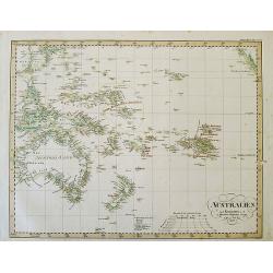
AUSTRALIEN nach Krusenstern u. A. in Meractors Projection...
A fantastic steel engraved map of Australia and the Pacific. Published in Stieler's Hand-Atlas.Dated 1826 but updated until around 1845 with superb geography and exact de...
Date: Gotha, c1846
Selling price: ????
Please login to see price!
Sold in 2012

Djar Mougal de la Milice Lesghine Djar. 29
A very decorative print of a Moghul (also spelled Mughal) from the Lesghine militia after Prince Grigory Grigorievich Gagarin and lithographed by J.Keller. Printed by Lem...
Date: Paris, A.Hauser, ca. 1846
Selling price: ????
Please login to see price!
Sold in 2012

Milice Georgienne à Zakataly.
A very decorative print of Georgian militia in Zakataly in the Azerbaijan region after Prince Grigory Grigorievich Gagarin and lithographed by J.Keller. Printed by Lemerc...
Date: Paris, A.Hauser, ca. 1846
Selling price: ????
Please login to see price!
Sold in 2012

Asflan, Kadi de Tsoudakhar. 38
A very decorative print of a Turkish judge of Tsoudakhar in the Daghestan central region after Prince Grigory Grigorievich Gagarin and lithographed by J.Keller. Printed b...
Date: Paris, A.Hauser, ca. 1846
Selling price: ????
Please login to see price!
Sold in 2015

Femme de Kazanistih. Domaine du Chamkhal de Tarky. 39
A very decorative print of a woman from Kazanistih, a Domain of Tarky in Dagestan after Prince Grigory Grigorievich Gagarin and lithographed by J.Keller. Printed by Lemer...
Date: Paris, A.Hauser, ca. 1846
Selling price: ????
Please login to see price!
Sold

TOUCHINE. Costumes du Caucase.
A very decorative print of a Tuchin peasant from Dagestan by Prince Gagarine. Good detail of the costume.The Kumyks live in the plains and the foothills of Dagestan. They...
Date: Paris, A.Hauser, ca. 1846
Selling price: ????
Please login to see price!
Sold