Browse Listings
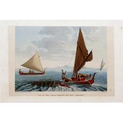
Vue De L'Île Tinian: Pirogues des ÎLes Carolines.
Superb stipple engraving with fantastic color showing two boats and several native sailors. In the background two more boats and an island are visible. By Taunay for Frey...
Date: Paris, 1825
Selling price: ????
Please login to see price!
Sold in 2016

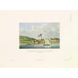
Vue d'une distillerie sur l'Ìle Guam.
Rare and beautiful view of a distillery on Guam Island. By Chasselat after Pellion, engraved by Pomel. Published in the important Voyage autour du monde under the command...
Date: Paris, 1825
Selling price: ????
Please login to see price!
Sold in 2016

Femme de l'Ile Guam: Josephe Cortez.
Rare and beautiful image of a woman from Guam. Located in the western Pacific Ocean, Guam is one of five American territories with an established civilian government. By...
Date: Paris, 1825
Selling price: ????
Please login to see price!
Sold in 2018
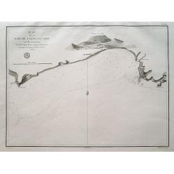
Plan de la Baie de Lyeoung-Soy en l'Île d'Hainan...
A scarce sea-chart from the explorations of Achille de Kergariou in 1817, showing a part of southern Hainan (Lingshui Bay?). With the tracks of the ships, small rocks and...
Date: Paris, ca. 1825
Selling price: ????
Please login to see price!
Sold in 2016
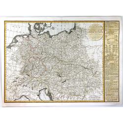
Carte de l'Allemagne Contenant les Etats de la Confédération Germanique, le Royaume de Prusse.
A large, finely detailed map of central Europe, showing the Confederation of the Rhine, which was formed in 1806 by a group of Germans, that decided to throw their nation...
Date: Paris, 1825
Selling price: ????
Please login to see price!
Sold in 2016
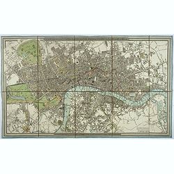
A new Plan of London and Westminster, with the borough of Southwark. 1825.
Beautiful plan of London, Westminster and Southwark, with parks and gardens in green published by James Wyld. To the right of the plan are the famous London docks built i...
Date: London, 1825
Selling price: ????
Please login to see price!
Sold in 2017
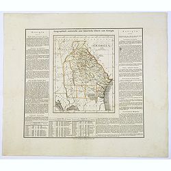
Geographisch-Statistische und Historische Charte von Georgia.
A nice map of the southern US state of Georgia, from the German version of Carey and Lea's English language atlas. This atlas was issued in six editions, from 1822-1827, ...
Date: Weimar, 1825
Selling price: ????
Please login to see price!
Sold in 2017
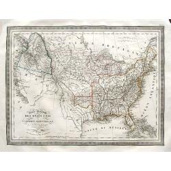
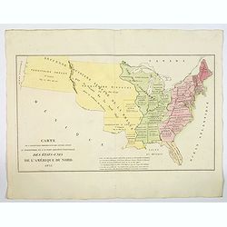
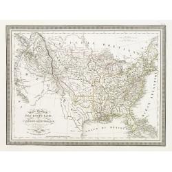
Carte Générale des Etats Unis de L'Amérique Septentrionale. . .
A highly interesting map of much of today's USA, the Bahamas, and parts of Canada. The map features the 54° 40' or Fight border with the huge Northwest region extending ...
Date: Paris, 1825
Selling price: ????
Please login to see price!
Sold in 2018
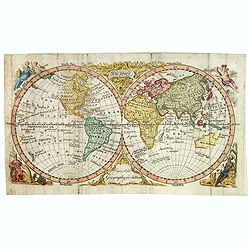
The World.
A very attractive small twin hemisphere world map "Engraved for Geography for Children." Peoples of the four continents adorn each corner of the map, but the en...
Date: London, ca 1825
Selling price: ????
Please login to see price!
Sold in 2018
![North America [2 maps].](/uploads/cache/42445-250x250.jpg)
North America [2 maps].
A differing pair of North American maps, both published in 1820s, one in London, the other in Edinburgh. The map published by Constable, after Arrowsmith shows N. America...
Date: London, Edinburgh 1820 -1825
Selling price: ????
Please login to see price!
Sold in 2020
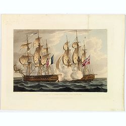
Capture of L'Immoratalite, Oct 20th 1798.
A nice colored aquatint of a naval battle from Jenkins Naval Achievements of Great Britain from the Year 1793 to 1817. It shows the an English warship alongside the Frenc...
Date: London, ca 1825
Selling price: ????
Please login to see price!
Sold in 2018
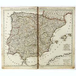
Karte der beeden koenidreiche Spanien und Portugal.
Uncommon map of Spain and Portugal published by Johannes Walch.Johann Walch (1757-1824) was cartographer and map publisher active in Augsburg, he was the son-in-law of Jo...
Date: Augsburg, 1825
Selling price: ????
Please login to see price!
Sold in 2019
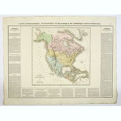
Carte Géographique, Statistique et Historique L'Amerique Septentrionale.
A lovely detailed map of North America, from Buchon's, Atlas Gégraphique Statistique, historique et chronologique des deux Ameriques et des isles adjacentes: traduit de ...
Date: Paris, 1825
Selling price: ????
Please login to see price!
Sold in 2019
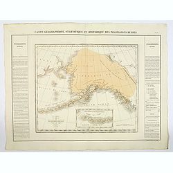
Carte Geographique, Statistique et Historique des Possessions Russes.
A very significant, desirable map of Alaska still possessed by Russia, From Buchon's Atlas Gégraphique Statistique, historique et chronologique des deux Ameriques et des...
Date: Paris, 1825
Selling price: ????
Please login to see price!
Sold in 2019
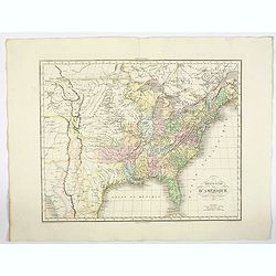
Etats-Unis d'Amerique.
A nicely detailed map of the U.S.A., showing the various states with their political borders, in fine original colors. This interesting map shows the Oregon Territory, th...
Date: Paris, 1825
Selling price: ????
Please login to see price!
Sold in 2019
Carte de l'Adjonction Progressive des divers Etats au Territoire et a l'Union Constitutionnelle des Etats-Unis de l'Amerique du Nord. 1825.
An interesting map of the United States from Buchon's Atlas Gégraphique Statistique, historique et chronologique des deux Ameriques et des isles adjacentes, traduit de l...
Date: Paris, 1825
Selling price: ????
Please login to see price!
Sold in 2019
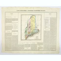
Carte Geographique, Statistique et Historique du Maine.
A finely engraved early map of the state of Maine, U.S.A., hand colored by counties. It includes roads, towns, rivers, and lakes and there are key note flags for 10 Maine...
Date: Paris, 1825
Selling price: ????
Please login to see price!
Sold in 2022
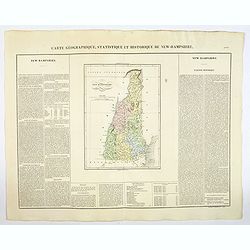
Carte Geographique, Statistique et Historique du New Hampshire.
A detailed map of New Hampshire, from Buchon's Atlas Gégraphique Statistique, historique et chronologique des deux Ameriques et des isles adjacentes, traduit de l'atlas ...
Date: Paris, 1825
Selling price: ????
Please login to see price!
Sold in 2019
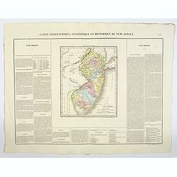
Carte Géographique, Statistique et Historique du New-Jersey.
A detailed map of New Jersey, from Buchon's Atlas Gégraphique Statistique, historique et chronologique des deux Amériques et des isles adjacentes: traduit de l'atlas ex...
Date: Paris, 1825
Selling price: ????
Please login to see price!
Sold in 2019
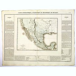
Carte Geographique, Statistique ey Historique du Mexique.
A lovely, detailed map of Mexico, from Buchon's, Atlas Gégraphique Statistique, historique et chronologique des deux Ameriques et des isles adjacentes traduit de l'atlas...
Date: Paris, 1825
Selling price: ????
Please login to see price!
Sold in 2019
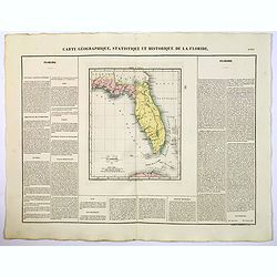
Carte Geographique, Statistique ey Historique de la Floride.
A lovely, detailed map of Florida, from Buchon's, Atlas Gégraphique Statistique, historique et chronologique des deux Ameriques et des isles adjacentes traduit de l'atla...
Date: Paris, 1825
Selling price: ????
Please login to see price!
Sold in 2022
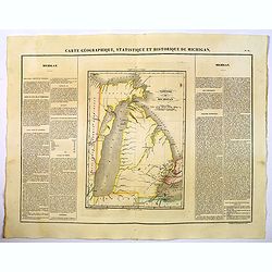
Carte Geographique, Statistique et Historique de Michigan.
A nice detailed map of Michigan, from Buchon's Atlas Gégraphique Statistique, historique et chronologique des deux Ameriques et des isles adjacentes traduit de l'atlas e...
Date: Paris, 1825
Selling price: ????
Please login to see price!
Sold in 2019
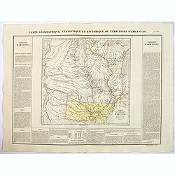
Carte Geographique, Statistique et Historique du Territoire d'Arkansas.
A nice detailed map of the Territory of Arkansas, from Buchon's Atlas Gégraphique Statistique, historique et chronologique des deux Ameriques et des isles adjacentes tra...
Date: Paris, 1825
Selling price: ????
Please login to see price!
Sold in 2019
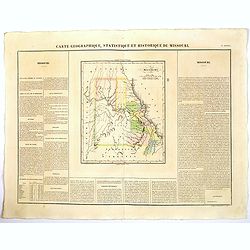
Carte Geographique, Statistique et Historique du Territoire Missouri.
A nice detailed map of the state of Missouri, from Buchon's Atlas Gégraphique Statistique, historique et chronologique des deux Ameriques et des isles adjacentes traduit...
Date: Paris, 1825
Selling price: ????
Please login to see price!
Sold in 2019
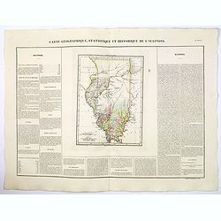
Carte Geographique, Statistique et Historique de Illinois.
A nice detailed map of the state of Illinois, from Buchon's Atlas Gégraphique Statistique, historique et chronologique des deux Ameriques et des isles adjacentes traduit...
Date: Paris, 1825
Selling price: ????
Please login to see price!
Sold in 2019
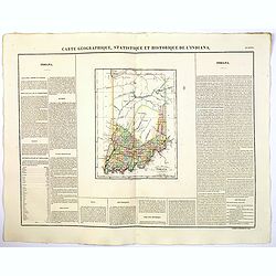
Carte Geographique, Statistique et Historique de L'Indiana.
A nice detailed map of the state of Indiana from Buchon's Atlas Gégraphique Statistique, historique et chronologique des deux Ameriques et des isles adjacentes traduit d...
Date: Paris, 1825
Selling price: ????
Please login to see price!
Sold in 2019
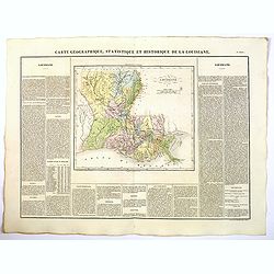
Carte Geographique, Statistique et Historique de Louisiane.
A nice detailed map of the state of Louisiana from Buchon's Atlas Gégraphique Statistique, historique et chronologique des deux Ameriques et des isles adjacentes traduit...
Date: Paris, 1825
Selling price: ????
Please login to see price!
Sold in 2022
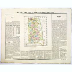
Carte Geographique, Statistique et Historique de d'Alabama.
A nice detailed map of the state of Alabama from Buchon's Atlas Gégraphique Statistique, historique et chronologique des deux Ameriques et des isles adjacentes traduit d...
Date: Paris, 1825
Selling price: ????
Please login to see price!
Sold in 2019
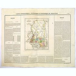
Carte Geographique, Statistique et Historique de Mississipi.
A nice detailed map of the state of Mississippi from Buchon's Atlas Gégraphique Statistique, historique et chronologique des deux Ameriques et des isles adjacentes tradu...
Date: Paris, 1825
Selling price: ????
Please login to see price!
Sold in 2020
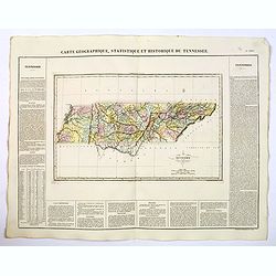
Carte Geographique, Statistique et Historique du Tennessee.
A nice detailed map of the state of Tennessee from Buchon's Atlas Gégraphique Statistique, historique et chronologique des deux Ameriques et des isles adjacentes traduit...
Date: Paris, 1825
Selling price: ????
Please login to see price!
Sold in 2019
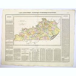
Carte Geographique, Statistique et Historique du Kentucky.
A nice detailed map of the state of Kentucky from Buchon's Atlas Gégraphique Statistique, historique et chronologique des deux Ameriques et des isles adjacentes traduit ...
Date: Paris, 1825
Selling price: ????
Please login to see price!
Sold in 2021
Carte Geographique, Statistique et Historique de L'Ohio.
A nice detailed map of the state of Ohio from Buchon's Atlas Gégraphique Statistique, historique et chronologique des deux Ameriques et des isles adjacentes traduit de l...
Date: Paris, 1825
Selling price: ????
Please login to see price!
Sold in 2022
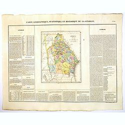
Carte Geographique, Statistique et Historique de la Georgie.
A nice detailed map of the state of Georgia from Buchon's Atlas Gégraphique Statistique, historique et chronologique des deux Ameriques et des isles adjacentes traduit d...
Date: Paris, 1825
Selling price: ????
Please login to see price!
Sold in 2022
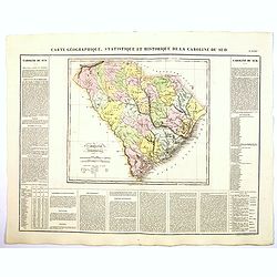
Carte Geographique, Statistique et Historique de la Caroline du Sud.
A nice detailed map of the state of South Carolina from Buchon's Atlas Gégraphique Statistique, historique et chronologique des deux Ameriques et des isles adjacentes tr...
Date: Paris, 1825
Selling price: ????
Please login to see price!
Sold in 2019
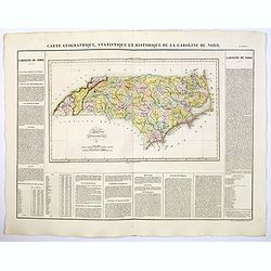
Carte Geographique, Statistique et Historique de la Caroline du Nord.
A nice detailed map of the state of North Carolina from Buchon's Atlas Gégraphique Statistique, historique et chronologique des deux Ameriques et des isles adjacentes tr...
Date: Paris, 1825
Selling price: ????
Please login to see price!
Sold in 2019

Carte Geographique, Statistique et Historique de la Virginie.
A nice detailed map of the state of Virginia from Buchon's Atlas Gégraphique Statistique, historique et chronologique des deux Ameriques et des isles adjacentes traduit ...
Date: Paris, 1825
Selling price: ????
Please login to see price!
Sold in 2020
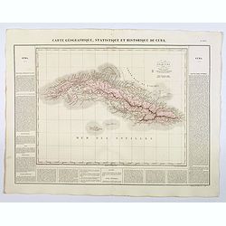
Carte Geographique, Statistique et Historique de Cuba.
A nice detailed map of the island of Cuba, from Buchon's Atlas Gégraphique Statistique, historique et chronologique des deux Ameriques et des isles adjacentes traduit de...
Date: Paris, 1825
Selling price: ????
Please login to see price!
Sold in 2019
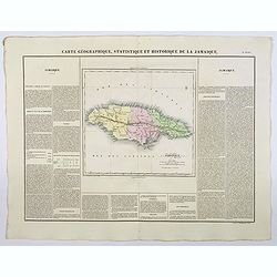
Carte Geographique, Statistique et Historique de la Jamaique.
A nice detailed map of the island of Jamaica, from Buchon's Atlas Gégraphique Statistique, historique et chronologique des deux Ameriques et des isles adjacentes traduit...
Date: Paris, 1825
Selling price: ????
Please login to see price!
Sold in 2023
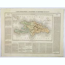
Carte Geographique, Statistique et Historique de Haity.
A nice detailed map of the island of Haiti, from Buchon's Atlas Gégraphique Statistique, historique et chronologique des deux Ameriques et des isles adjacentes traduit d...
Date: Paris, 1825
Selling price: ????
Please login to see price!
Sold in 2019
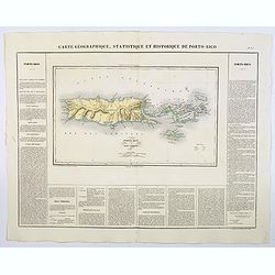
Carte Geographique, Statistique et Historique de Porto-Rico.
A nice detailed map of the island of Porto-Rico, and the Virgin Islands, from Buchon's Atlas Gégraphique Statistique, historique et chronologique des deux Ameriques et d...
Date: Paris, 1825
Selling price: ????
Please login to see price!
Sold in 2019
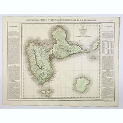
Carte Geographique, Statistique et Historique de la Guadeloupe.
A nice detailed map of the island of Guadeloupe, from Buchon's Atlas Gégraphique Statistique, historique et chronologique des deux Ameriques et des isles adjacentes trad...
Date: Paris, 1825
Selling price: ????
Please login to see price!
Sold in 2019
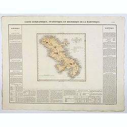
Carte Geographique, Statistique et Historique de la Martinique.
A nice detailed map of the island of Martinique, from Buchon's Atlas Gégraphique Statistique, historique et chronologique des deux Ameriques et des isles adjacentes trad...
Date: Paris, 1825
Selling price: ????
Please login to see price!
Sold in 2019
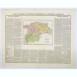
Carte Geographique, Statistique et Historique de la Republique Colombienne.
A nice detailed map of Columbia from Buchon's Atlas Gégraphique Statistique, historique et chronologique des deux Ameriques et des isles adjacentes traduit de l'atlas ex...
Date: Paris, 1825
Selling price: ????
Please login to see price!
Sold in 2019
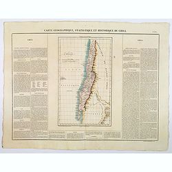
Carte Geographique, Statistique et Historique du Chili.
A nice detailed map of Chile from Buchon's Atlas Gégraphique Statistique, historique et chronologique des deux Ameriques et des isles adjacentes traduit de l'atlas exéc...
Date: Paris, 1825
Selling price: ????
Please login to see price!
Sold in 2019
![[Map of Martrimony]](/uploads/cache/42145-250x250.jpg)
[Map of Martrimony]
A rare anonymous early 19th century manuscript map of Matrimony. Among the many names are Rocks of jealousy, Sea of flirtation, P. of proposal, Kingdom of suspense, Land ...
Date: ca. 1800 - 1825
Selling price: ????
Please login to see price!
Sold in 2019

Découverte de la vaccine son caractère. ... Les notes explicatives ont été rédigées par le Cen. Chaussier.
Broadsheets etchings each with two vignettes and extensive descriptive text about the cow-pox disease. Composed by François Chaussier and etched by L. Baltard.Francois C...
Date: Paris, ca. 1825
Selling price: ????
Please login to see price!
Sold in 2023
![Carta Di S. Domingo / Carta Delle Isole Antille. [Set of 2 maps]](/uploads/cache/45844-250x250.jpg)
Carta Di S. Domingo / Carta Delle Isole Antille. [Set of 2 maps]
Set of two maps of St. Domingo and Antilles. Size of St. Domingo is 335mm x 410mm and size of Antilles is 415mm x 340mm.From "Nuovo Atlante di Geografia Universale.....
Date: Milan, Batelli, 1825
Selling price: ????
Please login to see price!
Sold in 2021
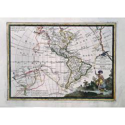
L'America secondo le ultime osservazioni divisa ne' suoi stati principali.
Rare last edition of Cassini's map of America, showing the voyages of Captain James Cook through the South Pacific, Hawaii, New Zealand and the Northwest Coast of America...
Date: Rome, 1825
Selling price: ????
Please login to see price!
Sold in 2020
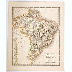
Brazil and Paraguay.
A large, detailed map of Brazil and Paraguay taken from Hall's scarce 'New General Atlas', published just after the Brazilian war of independence, which ceded this enormo...
Date: London, 1825
Selling price: ????
Please login to see price!
Sold in 2020
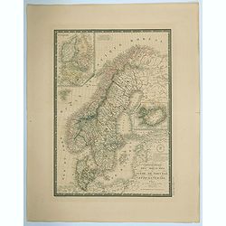
Carte Generale des Royaumes de Suede, de Norvege et de la Danemark.
A fine and detailed large map of the region with insets of Denmark, Faroe Islands, and Iceland. A scroll style title with the embossed royal seal, a keyboard style border...
Date: Paris, 1825
Selling price: ????
Please login to see price!
Sold in 2021

Wormerveer village de la Nord Hollande.
Print showing ice skating in the village Wormerveer situated in the Dutch province Noord-Holland. From “Voyage Pittoresque dans le Royaume des Pays-Bas”, by Mr. De Cl...
Date: Brussels, J. B. A. Jobard, 1825
Selling price: ????
Please login to see price!
Sold in 2023
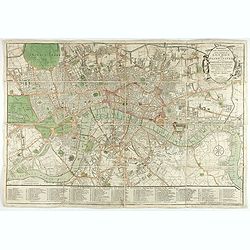
Bowles's one-sheet pan of the cities of London and Westminster
Bowles detailed map of London was updated regularly through the first decade of the 19th century. In addition to providing large scale detail, Bowles maps are also illust...
Date: London, 1825
Selling price: ????
Please login to see price!
Sold in 2022
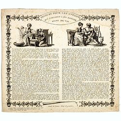
Secours pour les enfants qui naissent sans donner signe de vie.
Broadsheets etchings with two vignettes and extensive descriptive text about child born without sign of life.Composed by François Chaussier and etched by L. Baltard. Fra...
Date: Paris, ca. 1825
Selling price: ????
Please login to see price!
Sold in 2023
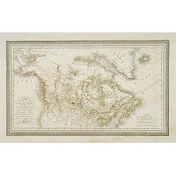
Carte de la partie septentrionale du Nouveau Monde..
Detailed map of Canada and Alaska. Prepared by L.Vivien and engraved in steel by Giraldon-Bovinet. Published by Menard and Desenne, rue Git-le-Ceur 8, Paris.
Date: Paris, 1825
Selling price: ????
Please login to see price!
Sold in 2011

Chapeau de bois dit paille de riz.. (2308)
From Costume Parisien (1797-1839).Paris was the capital for fashion innovation and design. After the final defeat of Napoleon, English and French fashions merged to close...
Date: Paris 1825
Selling price: ????
Please login to see price!
Sold in 2009
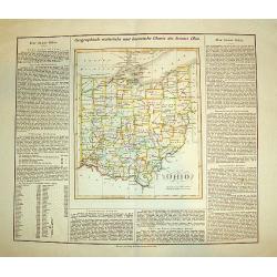
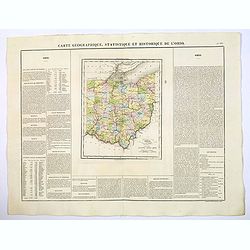
OHIO (Geographisch - statistische und historische Charte de Staates Ohio)
From the rare German edition of Carey and Lea?s, A Complete Historical, Chronological, and Geographical American Atlas, an early and impressive map of Ohio bordered with ...
Date: London and Weimar, 1825
Selling price: ????
Please login to see price!
Sold
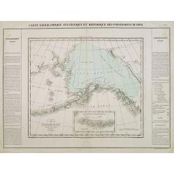
Carte des Possessions Russes.
A very significant, desirable map of Alaska still possessed by Russia. From J.A. Buchon, "Atlas Gégraphique Statistique, historique et chronologique des deux Ameriq...
Date: Paris, 1825
Selling price: ????
Please login to see price!
Sold in 2012
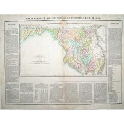
Carte Géographique .. du Maryland.
"Detailed map of Maryland. From J.A. Buchon, ""Atlas Gégraphique Statistique, historique et chronologique des deux Ameriques et des isles adjacentes; trad...
Date: Paris 1825
Selling price: ????
Please login to see price!
Sold
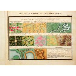
Principes du Dessin et du Lavis de la Carte Topographique.
8vo, oblong, 92 pp, leather (a bit chafed), back gold-stamped. With 3 folding tables and 9 (8 hand-colored) plates.Important instruction book on the drawing and coloring ...
Date: Paris, 1825
Selling price: ????
Please login to see price!
Sold
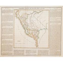
Peru.
This is the map of Peru is from a plano edition of the very scarce German edition of Carey & Lea's "A Complete Historical, Chronological, and Geographical Americ...
Date: Weimar, 1822-1825
Selling price: ????
Please login to see price!
Sold
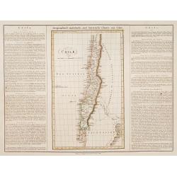
Chili.
This is the map of Chilli is from a plano edition of the very scarce German edition of Carey & Lea's "A Complete Historical, Chronological, and Geographical Amer...
Date: Weimar, 1822-1825
Selling price: ????
Please login to see price!
Sold
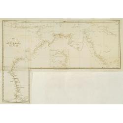
Chart of the intertropical & west coasts of AUSTRALIA as surveyed in the years 1818 to 1822..
Fine detailed map of the north and west coast of Australia and Indonesia. Engraved by J.Walker and published by John Murray.With inset map of the continent of Australia.
Date: London 1825
Selling price: ????
Please login to see price!
Sold
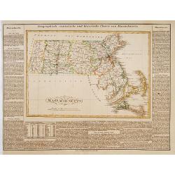
Massachusetts.
This is the map of Massachusetts is from a plano edition of the very scarce German edition of Carey & Lea's "A Complete Historical, Chronological, and Geographic...
Date: Weimar, 1822-1825
Selling price: ????
Please login to see price!
Sold
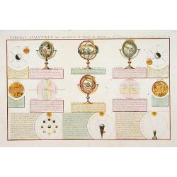
Tableau Analytique des Différens..
The illustrated globes and spheres are similar to the ones sold by Delamarche. Also depicting Sun, Moon and several positions. Engraved by Pelicier.
Date: Paris, 1825
Selling price: ????
Please login to see price!
Sold in 2013
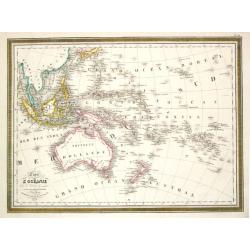
Carte de L\'Oceanie. Paris, 1824.
Louis Vivien de Saint Vivien. French cartographer. Atlas Universal, 1825.A map of the Pacific.
Date: Paris, 1825
Selling price: ????
Please login to see price!
Sold in 2017
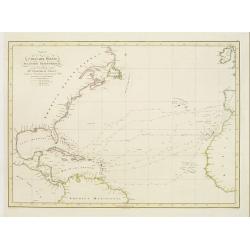
Carta del Oceano Atlantico Setentrional, con las Derrotas que siguió Dn. Cristobal Colon ..
Map of the North Atlantic Ocean, illustrating Christopher Columbus' routes to the New World in 1492, 1495, 1498, 1502.POublished by the "Deposito Hidrografico" ...
Date: Madrid 1825
Selling price: ????
Please login to see price!
Sold
Carte Générale des Etats Unis de L''Amérique Septentrionale..
Detailed map of the United States. Prepared by L.Vivien and engraved in steel by Giraldon-Bovinet.Published by Menard and Desenne, rue Git-le-Ceur 8, Paris.
Date: Paris, 1825
Selling price: ????
Please login to see price!
Sold in 2015

Autour radieux, jeune. Autour tyran. Autour a calotte noire.
3 original handcolored copperplate engravings from Temmnick's Nouveau Receuil des Planches coloriees d'oiseau. (New Collection of Colored Plates of Birds) these prints ar...
Date: Amsterdam, 1825
Selling price: ????
Please login to see price!
Sold in 2010

Colombar Capelle, male
Original handcolored copperplate engraving from Temmnick's Nouveau Receuil des Planches coloriees d'oiseau. (New Collection of Colored Plates of Birds) this print is name...
Date: Amsterdam, 1825
Selling price: ????
Please login to see price!
Sold in 2010
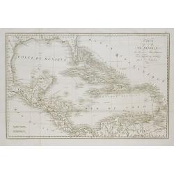
Carte du Golfe du Mexique, des Iles et des Pays Adjacens . . .
Folding map after Robert Benard's map, "Carte du Golfe de Mexique," published in William Robertson's 1778 "Histoire de l'Amerique."
Date: Paris, c.1825
Selling price: ????
Please login to see price!
Sold in 2011
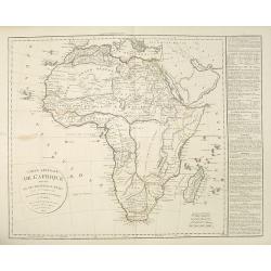
Carte générale de L'Afrique divisée en ses principaux états par Fx Delamarche. . .
Uncommon map of Africa prepared by Felix Delamarche, after R.de Vaugondy. The "Zahara ou Grand désert" and Congo and Zambia "Contrée tout-a-fait Inconnue...
Date: Paris, 1825
Selling price: ????
Please login to see price!
Sold
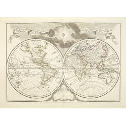
Mappemonde a l'usage de l'instr.on. Par Guillaume Delisle et Philippe Buache.
An updated version of the double hemisphere world map by Buache of 1785. The original dedication to the King is removed, as the map was printed after the French Revolutio...
Date: Paris, 1825
Selling price: ????
Please login to see price!
Sold in 2010
![Carte Géographique [. . .] Connecticut.](/uploads/cache/14220-250x250.jpg)
Carte Géographique [. . .] Connecticut.
Detailed map of Connecticut. From J.A. Buchon, Atlas Gégraphique Statistique, historique et chronologique des deux Amériques et des isles adjacentes, traduit de l'atlas...
Date: Paris, 1825
Selling price: ????
Please login to see price!
Sold in 2015
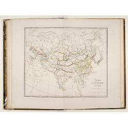
Tableaux historiques de l'Asie..
This atlas, by Martin Heinrich Klaproth (1743-1817), presents 27 geographical charts recalling the history of the Asian continent from the 6th century BC till the 19th AC...
Date: Paris, 1826
Selling price: ????
Please login to see price!
Sold

Tulipe des Jardins.
Finely executed water color with title in bottom, Tulipe des Jardins signed and dated lower right, Jules Alex Delahaye. 1826Representing a superb tulip with dark purple p...
Date: France 1826
Selling price: ????
Please login to see price!
Sold

Cascade de Fanafaoua près du village de Kidikidi.
Original hand colored engraving by Ambroise Tardieu taken from the rare and important book " Voyage autour du Monde, exécuté par ordre du Roi, sur la corvette de s...
Date: Paris, Arthus Bertrand, 1826
Selling price: ????
Please login to see price!
Sold in 2011
An atlas of ancient geography.
A small atlas with 21 maps made by Samuel Butler. The atlas has a titlepage, index, 21 maps of ancient geography in original out line color and a name index at the end.
Date: London, 1826
Selling price: ????
Please login to see price!
Sold
Nouvelle-Zélande.
Original hand colored engraving by Ambroise Tardieu taken from the rare and important book " Voyage autour du Monde, exécuté par ordre du Roi, sur la corvette de s...
Date: Paris, Arthus Bertrand, 1826
Selling price: ????
Please login to see price!
Sold in 2011
Etablissement des Missionnaires Anglais a Kidikidi (Nouvelle-Zélande)
Original hand colored engraving by Ambroise Tardieu taken from the rare and important book " Voyage autour du Monde, exécuté par ordre du Roi, sur la corvette de s...
Date: Paris, Arthus Bertrand, 1826
Selling price: ????
Please login to see price!
Sold in 2011

Coiffures ornées de cordons. . .(2461)
From "Costume Parisien" (1797-1839). Paris was the capital for fashion innovation and design. After the final defeat of Napoleon, English and French fashions me...
Date: Paris, 1826
Selling price: ????
Please login to see price!
Sold in 2016