Browse Listings
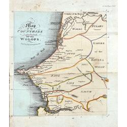
Map of the Countries Inhabited by the Wolofs
Rare map of Senegal and Gambia. The map is shows good detail of villages, regionas, and topographical features. Published in Ackermann's The World in Miniature. Africa.....
Date: London, 1822
Selling price: ????
Please login to see price!
Sold in 2022
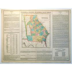
Geographical, Statistical and Historical Map of Georgia
Nice example of this fine map of Georgia, from the 1827 edition of Carey & Lea's Geographical, Statistical and Historical Atlas of America, with two columns of conte...
Date: Philadelphia, 1822
Selling price: ????
Please login to see price!
Sold in 2023
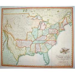
United States of America Compiled from the latest and best..
An uncommon and important map by the well recognized American cartographer John Melish, engraved by Samuel Harrison. Melish was the first American publisher to issue excl...
Date: Philadelphia, 1822
Selling price: ????
Please login to see price!
Sold

Chapeau de velours plein.. (2047)
From Costume Parisien (1797-1839).Paris was the capital for fashion innovation and design. After the final defeat of Napoleon, English and French fashions merged to close...
Date: Paris 1822
Selling price: ????
Please login to see price!
Sold
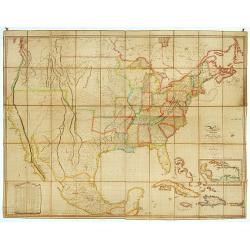
Map of the United States with contiguous British & Spanish Possessions.
.. compiled from the latest & best authorities by John Melish. Engraved by J. Vallance and [H.S.] Tanner. Entered according to Act of Congress the 16.th day of June 1...
Date: Philadelphia, 1822
Selling price: ????
Please login to see price!
Sold
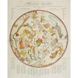
Planisferio Celeste..
Decorative large-scale hemisphere celestial chart, with a diameter 603mm., calculated for the year 1800. With descriptive key to zodiac signs in German, French and Italia...
Date: Milan, c.1822
Selling price: ????
Please login to see price!
Sold in 2009
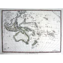
Karte von Australien oder der fünfte Welttheil.
RARE map of Indonesia, Australia, and the South Pacific! Engraved by Rudolph von Rothenburg, and published by Artaria. Large and very detailed map including many even sm...
Date: Vienna, 1822
Selling price: ????
Please login to see price!
Sold in 2011
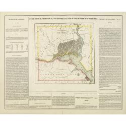
Geographical, statistical, and historical map of the district of Columbia.
Includes a detailed plan of Washington DC, Georgetown and Alexandria and a number of roads and rivers in the District. Muds Tavern is shown just outside the District on t...
Date: Philadelphia, 1822
Selling price: ????
Please login to see price!
Sold in 2010

Doctor Syntax setting out in search of a wife.
Charming title page for "Doctor Syntax.. .. in Search of a Wife .. Printed by R. Ackermann.
Date: London, 1823
Selling price: ????
Please login to see price!
Sold in 2023
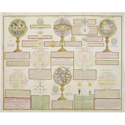
Tableau Analytique des différentes positions de la Sphère, des différens systemes, des révolutions et des distances des Planètes, &c
Containing "Globe Celeste", "Sphere de Copernic", "Globe Terrestre", "Systeme de Ptolomee" ; including diagrams of the solar syste...
Date: Paris, 1823
Selling price: ????
Please login to see price!
Sold in 2014
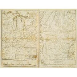
Country drained by the Mississippi Eastern Section. (with) Country of the Mississippi.
Rare map in two sheets stretching from Mississippi to Lake Superior. An inset box at top right includes a series of explanations to the symbols on the map. From: "Ac...
Date: Philadelphia, 1823
Selling price: ????
Please login to see price!
Sold
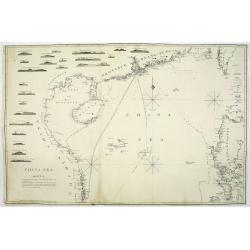
China Sea. sheet 1.
James Horsburgh early of the coast of China, including Hong Kong, Hainan, Strait of Formosa with lower half of Formosa (Taiwan), Northern part of the Philippines.The cha...
Date: London, 1823
Selling price: ????
Please login to see price!
Sold in 2011
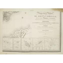
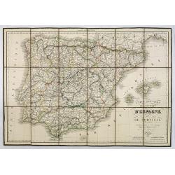
Mapa Civil ii Militar de Espana y Portugal con la nueva Division en distritos enriquecido de los planes particulares de 34 ciudades y puertos principales dedicado A las heroicas naciones espanola y portuguesa. . .
Lower right sheet of a rare six sheet map of Spain and Portugal in its 34 newly divided districts, printed in Paris with Noël et Dauty. Beside the title there are 6 inse...
Date: Paris, 1823
Selling price: ????
Please login to see price!
Sold in 2008
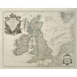
Les Isles Britanniques ou sont le Rme. D'Angleterre . . . Par G. De L'Isle. . . A Paris Chez Dezauche. . .
Uncommon map of the British Isles. The bottom right shows the coasts of the Netherlands, Belgium, and northern France and at the upper right is the southern tip of Norway...
Date: Paris, c.1823
Selling price: ????
Please login to see price!
Sold in 2009
Carte Routière des Royaumes d'Espagne et de Portugal.
Road map of Spain and Portugal. Editor and engraver by L. H. Berthe at the Rue St. Jacques N°66 .
Date: Paris, 1823
Selling price: ????
Please login to see price!
Sold in 2010
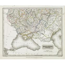
Russia in Europe south past.
Map showing the south of Russia around the Black Sea. Fine steel engraving by Sidney Hall after a drawing by A . Arrowsmith. Published by Archibald Constable
Date: Edinburg, c. 1823
Selling price: ????
Please login to see price!
Sold in 2010
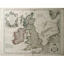
Les Isles Britanniques ou Sont le Rme d\"Angleterre Tire de Speci Celuy d\'Ecosse tire de the Pont &C et Celuy d\'Irlande tire de Petti le tout Rectife par Diverfes Observations.
Map of the British Isles by Guillaume De L'Isle. This wonderfully detailed map includes Great Britain, Scotland, Wales and Ireland, as well as the coast of France. All ma...
Date: Paris, 1823
Selling price: ????
Please login to see price!
Sold in 2010
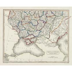
Russia in Europe south past.
Map sowing the area north of the Crimea region, north of the Black Sea and the Caspian Sea, including the Caucasus.
Date: London, Edinburgh, 1823
Selling price: ????
Please login to see price!
Sold in 2010
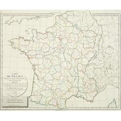
Cartes de France divisée en ses divers départemens,. . .
Map of France showing the different departments, all borders colored in outline.
Date: Paris, 1823
Selling price: ????
Please login to see price!
Sold
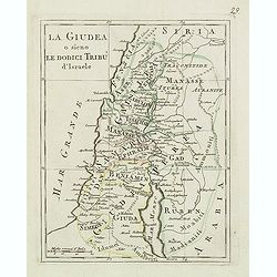
La Giudea o sieno le dodici tribu d'israele
Charming map of the Holy Land from the rare atlas Atlante Tascabile o sia Serie di Num. XXI Cartine Geografiche nelle quali si rappresenta in ristretto lo Stato Attuale d...
Date: Rome, 1823
Selling price: ????
Please login to see price!
Sold in 2014
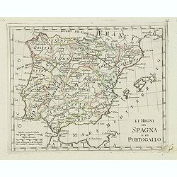
Il regni di spagna e di portogallo.
Charming map of Spain and Portugal from the rare atlas Atlante Tascabile o sia Serie di Num. XXI Cartine Geografiche nelle quali si rappresenta in ristretto lo Stato Attu...
Date: Rome, 1823
Selling price: ????
Please login to see price!
Sold in 2023
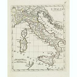
L'italia.
Charming map of Italy, with Corsica and Sardinia from the rare atlas Atlante Tascabile o sia Serie di Num. XXI Cartine Geografiche nelle quali si rappresenta in ristretto...
Date: Rome, 1823
Selling price: ????
Please login to see price!
Sold in 2023
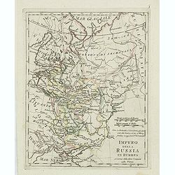
Impero della Russia in Europa. . .
Charming map of European part of Russia from the rare atlas Atlante Tascabile o sia Serie di Num. XXI Cartine Geografiche nelle quali si rappresenta in ristretto lo Stato...
Date: Rome, 1823
Selling price: ????
Please login to see price!
Sold in 2011
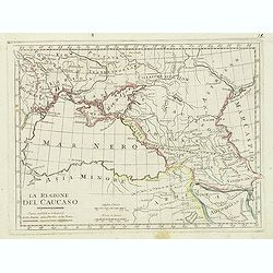
La regione del Caucaso. . .
Charming map of the region around the Black Sea from the rare atlas Atlante Tascabile o sia Serie di Num. XXI Cartine Geografiche nelle quali si rappresenta in ristretto ...
Date: Rome, 1823
Selling price: ????
Please login to see price!
Sold in 2011
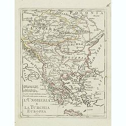
L'ungheria e la turchia Europea. . .
Charming map of Hungary, Macedonia, Bulgaria and Greece from the rare atlas Atlante Tascabile o sia Serie di Num. XXI Cartine Geografiche nelle quali si rappresenta in ri...
Date: Rome, 1823
Selling price: ????
Please login to see price!
Sold in 2011
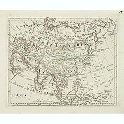
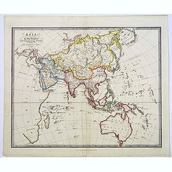
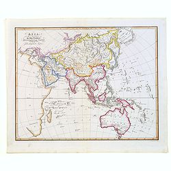
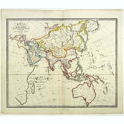
L'Asia
Charming map of the continent of Asia from the rare atlas Atlante Tascabile o sia Serie di Num. XXI Cartine Geografiche nelle quali si rappresenta in ristretto lo Stato A...
Date: Rome, 1823
Selling price: ????
Please login to see price!
Sold in 2013
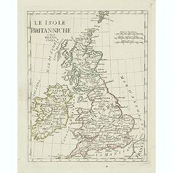
Le isole Britanniche. . .
Charming map of England, Ireland, Scotland from the rare atlas Atlante Tascabile o sia Serie di Num. XXI Cartine Geografiche nelle quali si rappresenta in ristretto lo St...
Date: Rome, 1823
Selling price: ????
Please login to see price!
Sold in 2011
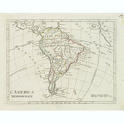
L'america meridionale.
Charming map of South America from the rare atlas Atlante Tascabile o sia Serie di Num. XXI Cartine Geografiche nelle quali si rappresenta in ristretto lo Stato Attuale d...
Date: Rome, 1823
Selling price: ????
Please login to see price!
Sold
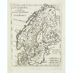
La scandinavia o sia i regni di suezia, norvegia e danimarca.
Charming and uncommon map of Scandinavia, including Norway, Sweden, Denmark, Finland and part of Russia, from the rare atlas Atlante Tascabile o sia Serie di Num. XXI Car...
Date: Rome, 1823
Selling price: ????
Please login to see price!
Sold in 2011
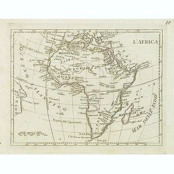
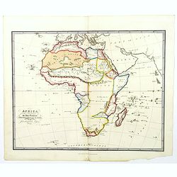
L'Africa.
Finely engraved map of Africa from the rare atlas Atlante Tascabile o sia Serie di Num. XXI Cartine Geografiche nelle quali si rappresenta in ristretto lo Stato Attuale d...
Date: Rome, 1823
Selling price: ????
Please login to see price!
Sold in 2011
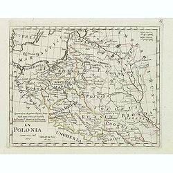
La Polonia comme era nel 1770.
Charming map of Poland during the year 1770 from the rare atlas Atlante Tascabile o sia Serie di Num. XXI Cartine Geografiche nelle quali si rappresenta in ristretto lo S...
Date: Rome, 1823
Selling price: ????
Please login to see price!
Sold in 2012
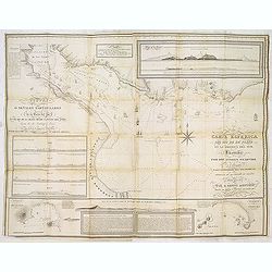
Carta esférica del Rio de la Plata en la América del Sur, Levantada por Don Andres Oyarvide. . .
Stunning chart of the Rio de la Plata with Buenos Aires, Montevideo, Maldonado, etc. prepared by Benito Aizpurúa. The map has several insets including "Puerto de Mo...
Date: Buenos Aires, ca.1823
Selling price: ????
Please login to see price!
Sold in 2013
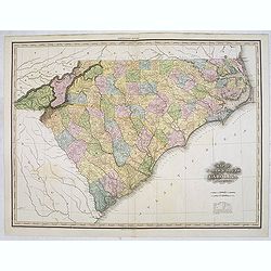
Map of North & South Carolina by H.S. Tanner.
Uncommon and important map of North and South Carolina by H.S. Tanner and published in his "New American Atlas" from 1823. Henry Schenck Tanner (1786-1858) was ...
Date: Philadelphia, Henry Tanner, 1823
Selling price: ????
Please login to see price!
Sold in 2014
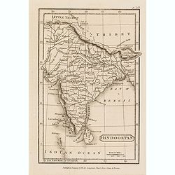
Hindoostan.
Somewhat later but very finely engraved and detailed map of India. Tibet is left blank. Published by Longman, Hurst, Rees, Orne & Brown, a London publishing company b...
Date: London, 1823
Selling price: ????
Please login to see price!
Sold in 2015
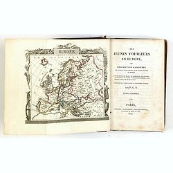
Les jeunes voyageurs en Europe, ou description raisonnée des divers pays compris dans cette partie du monde.
First edition of this fine travel companion illustrated with 16 very decorative maps, each map surrounded with local products and specialties of the region. Included are ...
Date: Paris, Lelong, 1823
Selling price: ????
Please login to see price!
Sold in 2015
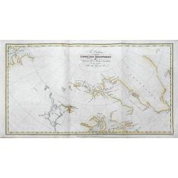
An Outline to shew the Connected Discoveries of Captains Ross, Parry & Franklin in the years 1818, 19, 20 and 21.
A rare first edition of this highly interesting map of early Arctic exploration. It shows the latest coast lines in the polar areas of Canada and Greenland. Two areas sho...
Date: London, 1823
Selling price: ????
Please login to see price!
Sold in 2016
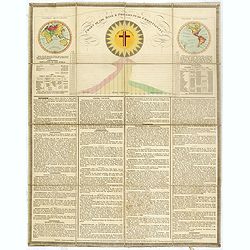
Chart of the rise & progress of christianity.
A very unusual folding sheet with in top double hemisphere hand colored world map with a note saying : In the map of the World, those parts colored RED, are inhabited by...
Date: London, after 1823
Selling price: ????
Please login to see price!
Sold in 2016
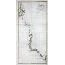
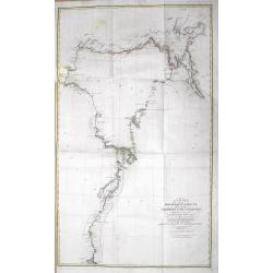
Route of the Expedition from Isle à la Crosse to Fort Providence in 1819 & 20.
A rare first edition of this chart illustrating John Franklin's (1786-1847) first Arctic land expedition (Coppermine Expedition) fromÎle-à-la-Crosse in Saskatchewan to ...
Date: London, 1823
Selling price: ????
Please login to see price!
Sold in 2016
A Chart of the Discoveries & Route of the Northern Land Expedition under the command of Captain Franklin, R.N. in the Years 1820 & 21...
A fantastic map showing John Franklin's expedition from Great Slave Lake to the Coronation Gulf (Nunavut) with incredible detail. It shows Fort Providence, Fort Enterpris...
Date: London, 1823
Selling price: ????
Please login to see price!
Sold in 2016
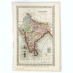
Hindoostan.
Somewhat later but very finely engraved and detailed map of India. Tibet is left blank. Published for the proprietors by Mr.Bull Holles St.Cavendish Square. Printed by Pe...
Date: London, 1823
Selling price: ????
Please login to see price!
Sold in 2017
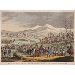
Napoleon Receiving The Sword of General Mack, on the Capitulation of Ulm.
An interesting historical engraving. Engraved by George Cruikshank from the original design of C. Vernet, executed at Paris by I. Duplessi Bertaux.Published on December 2...
Date: London, 1823
Selling price: ????
Please login to see price!
Sold in 2019

Napoleon Forcing the Passage of the Bridge of Arcola.
"Napoleon Forcing the Passage of the Bridge of Arcola."Engraved by George Cruikshank from the original design of C. Vernet, executed at Paris by I. Duplessi Ber...
Date: London, 1823
Selling price: ????
Please login to see price!
Sold in 2020
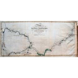
Route of the Expedition from York Factory to Cumberland House and the Summer & Winter Tracks from thence to Isle a La Crosse, in 1819 & 1820.
A rare first edition of this chart illustrating John Franklin's (1786-1847) first Arctic land expedition (Coppermine Expedition) from Île-à-la-Crosse in Saskatchewan to...
Date: London, 1823
Selling price: ????
Please login to see price!
Sold in 2016
A Plane Chart of the World on Mercator's Projection. . .
An unusual Children's educational world map, with exploration routes throughout the world shown. These include explorations by: Vancouver, Parry, Ross, Perouse, Cook and ...
Date: London, 1823
Selling price: ????
Please login to see price!
Sold in 2017
Asia for the Elucification of the Abbe Gaultier's Geographical Games.
An unusual Children's educational map of Asia.
Date: London, 1823
Selling price: ????
Please login to see price!
Sold in 2017
Route of the Expedition from Isle de la Crosse to Fort Providencein 1819 & 20.
A scarce chart of John Franklin's first Arctic land expedition from Ile a la Crosse in what is now Saskatchewan to Fort Providence on northern Great Slave Lake in what is...
Date: London, ca. 1823
Selling price: ????
Please login to see price!
Sold in 2017
Asia for the Elucification of the Abbe Gaultier's Geographical Games.
An unusual Children's educational map of Asia, Countries depicted in different colors, and with only some physical features engraved, like mountain ranges and rivers, som...
Date: London, 1823
Selling price: ????
Please login to see price!
Sold in 2017
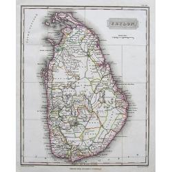
Ceylon.
A fine and richly detailed map of Sri Lanka. With numerous place names. Drawn by A. Arrowsmith, engraved by Sidney Hall, and published by Archibald Constable & Co., i...
Date: Edinburgh, 1823
Selling price: ????
Please login to see price!
Sold in 2017
Africa for the Elucification of the Abbe Gaultier's Geographical Games.
An unusual children's educational map of Africa, the various countries depicted in different colors, and with only some physical features engraved, like mountain ranges a...
Date: London, 1823
Selling price: ????
Please login to see price!
Sold in 2018
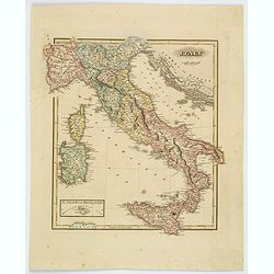
Italy.
Fielding Lucas's 1823 elegantly engraved map of Italy. Fielding Lucas' fine work distinguished him as one of the best publishers of his era. His maps are printed on a hig...
Date: Baltimore, 1823
Selling price: ????
Please login to see price!
Sold in 2019
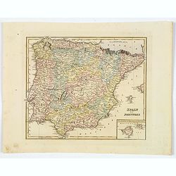
Spain and Portugal.
Fielding Lucas's 1823 elegantly engraved map of Spain & Portugal, with an inset of the islands of Majorca and Minorca. Fielding Lucas' fine work distinguished him as ...
Date: Baltimore, 1823
Selling price: ????
Please login to see price!
Sold in 2019
Asia for the Elucification of the Abbe Gaultier's Geographical Games.
An unusual Children's educational map of Asia, Countries depicted in different colors, and with only some physical features engraved, like mountain ranges and rivers, som...
Date: London, 1823
Selling price: ????
Please login to see price!
Sold in 2024
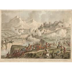
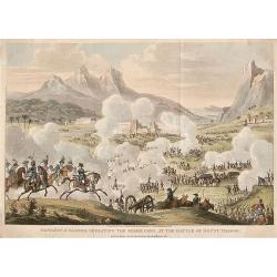
Napoleon & Massena Defeating The Austrian Army, At The Terrible Battle of Roveredo.
Napoleon & Massena defeating The Austrian Army, at The Terrible Battle of Roveredo, engraved by George Cruikshank from the original design of C. Vernet, executed at P...
Date: London, 1823
Selling price: ????
Please login to see price!
Sold in 2020
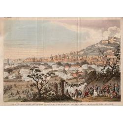
The Attack and Capture of Naples By The French After A Most Obstinate Resistance.
The Attack and Capture of Naples by The French After A Most Obstinate Resistance, engraved by George Cruikshank from the original design of C. Vernet, executed at Paris b...
Date: London, 1823
Selling price: ????
Please login to see price!
Sold in 2020
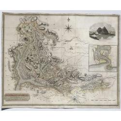
Dumbartonshire Sur'd by Wood for the Atlas of Scotland.
FA fne map of Dumbatonshire, Scotland by John Thomson in 1823. From his Atlas of Scotland published in Edinburgh. It features an inset of the Firth of Clyde and an engrav...
Date: Edinburgh, 1823
Selling price: ????
Please login to see price!
Sold in 2020
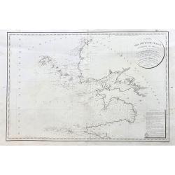
Carte des Cotes de France (environs de Brest) levee en 1816 1817 et 1818
A large sea-chart of the western parts of Finistère in the Bretagne, showing Ouessant, Brest, Plouguerneau, Crozon, Ile de Sein, and Audierne. With fantastic detail ...
Date: Paris, 1823
Selling price: ????
Please login to see price!
Sold in 2023
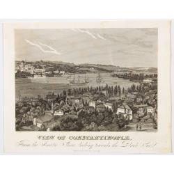
View of Constantinople from the Asiatic Shore, looking towards the Black Sea.
A very pleasant view of the iconic and influential city of Constantinople, which became Istanbul in 1930 after the formation of the Republic of Turkey. The city is seen f...
Date: London, ca 1823
Selling price: ????
Please login to see price!
Sold in 2023
Napoleon & Kleber Defeating the Mamelukes at the Battle of Mount Thabor.
An interesting historical engraving by George Cruikshank, from the original design of Swebach, published in Paris by I. Duplessi Bertaux. Published on March 1 1824, by Jo...
Date: London, 1824
Selling price: ????
Please login to see price!
Sold in 2020
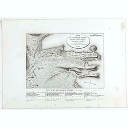
Plan de la Ville de Sydney.
Nice small plan of Sydney from Voyage de découvertes aux terres Australes by François Péron, 1824. This is one of the earliest depictions of the new English settlement...
Date: Paris, 1824
Selling price: ????
Please login to see price!
Sold in 2020
![Terre de Diemen et Nouvelle-Hollande. . . [plate III]](/uploads/cache/46266-250x250.jpg)
Terre de Diemen et Nouvelle-Hollande. . . [plate III]
A charming set of five coastal views from the southern tip of mainland Australia, and some of the islands in the Tasman Strait and of Tasmania, after the original sketche...
Date: Paris, 1824
Selling price: ????
Please login to see price!
Sold in 2020
![Terre de Diemen et Nouvelle-Hollande. . . [plate IV]](/uploads/cache/46267-250x250.jpg)
Terre de Diemen et Nouvelle-Hollande. . . [plate IV]
A charming set of four coastal views off the coast of Tasmania in Australia, after the original sketches by Lesueur, from Voyage de découvertes aux terres Australes by F...
Date: Paris, 1824
Selling price: ????
Please login to see price!
Sold in 2021
![Nouvelle-Hollande. . .[plate VI]](/uploads/cache/46269-250x250.jpg)
Nouvelle-Hollande. . .[plate VI]
A charming set of several coastal views off the west coast of Australia, after the original sketches by Lesueur, from Voyage de découvertes aux terres Australes by Fran�...
Date: Paris, 1824
Selling price: ????
Please login to see price!
Sold in 2020
![Nouvelle-Hollande. . .[plate VII]](/uploads/cache/46270-250x250.jpg)
Nouvelle-Hollande. . .[plate VII]
A charming set of five coastal views on the western and northern coast of Australia, after the original sketches by Lesueur, from Voyage de découvertes aux terres Austra...
Date: Paris, 1824
Selling price: ????
Please login to see price!
Sold in 2022
![Terre de Diemen. Bara-Ourou. [plate VIII]](/uploads/cache/46271-250x250.jpg)
Terre de Diemen. Bara-Ourou. [plate VIII]
A portrait of the Tasmanian Aboriginal Bara-Ourou, after the original sketches by Lesueur, from Voyage de découvertes aux terres Australes by François Péron, 1824.The ...
Date: Paris, 1824
Selling price: ????
Please login to see price!
Sold in 2024
![Terre de Diemen. Paraberi. [plate XI]](/uploads/cache/46274-250x250.jpg)
Terre de Diemen. Paraberi. [plate XI]
A portrait of the Tasmanian Aboriginal Paraberi, after the original sketches by Lesueur, from Voyage de découvertes aux terres Australes by François Péron, 1824.The Fr...
Date: Paris, 1824
Selling price: ????
Please login to see price!
Sold in 2024
![Terre de Diemen. Armes et Ornemens [plate XIII].](/uploads/cache/46276-250x250.jpg)
Terre de Diemen. Armes et Ornemens [plate XIII].
Set of five Aboriginal arms and ornaments, including spears, clubs, basket, necklace etc, after the original sketches by Lesueur, from Voyage de découvertes aux terres A...
Date: Paris, 1824
Selling price: ????
Please login to see price!
Sold in 2020
![Nouvelle-Hollande. Cour-Rou-Bari-Gal. [plate XVIII]](/uploads/cache/46281-250x250.jpg)
Nouvelle-Hollande. Cour-Rou-Bari-Gal. [plate XVIII]
A portrait of a male Tasmanian Aboriginal Cour-Rou-Bari-Gal by Lesueur, from Voyage de découvertes aux terres Australes by François Péron, 1824.The French expedition u...
Date: Paris, 1824
Selling price: ????
Please login to see price!
Sold in 2020
![Nouvelle-Hollande: Terre Napoleon. . . [plate V]](/uploads/cache/46268-250x250.jpg)
Nouvelle-Hollande: Terre Napoleon. . . [plate V]
A charming set of several views off the South Australian coast of Australia, after the original sketches by Lesueur, from Voyage de découvertes aux terres Australes by F...
Date: Paris, 1824
Selling price: ????
Please login to see price!
Sold in 2022
![Terre de Diemen. Navigation. [plate XIV].](/uploads/cache/46277-250x250.jpg)
Terre de Diemen. Navigation. [plate XIV].
Aboriginal boat, getting from island to island, or for gathering food, after the original sketches by Lesueur, from Voyage de découvertes aux terres Australes by Franço...
Date: Paris, 1824
Selling price: ????
Please login to see price!
Sold in 2023
![Nouvelle-Hollande - Y-Erran-Gou-La-Ga. [plate XIX]](/uploads/cache/46341-250x250.jpg)
Nouvelle-Hollande - Y-Erran-Gou-La-Ga. [plate XIX]
A portrait of a male Tasmanian Aboriginal Y-Erran-Gou-La-Ga by Lesueur, from Voyage de découvertes aux terres Australes by François Péron, 1824.The French expedition u...
Date: Paris, 1824
Selling price: ????
Please login to see price!
Sold in 2024
![Nouvelle-Hollande: Nelle Galles du sud - Norou-Gal-Derri s'avancant pour combattre. [plate XX]](/uploads/cache/46342-250x250.jpg)
Nouvelle-Hollande: Nelle Galles du sud - Norou-Gal-Derri s'avancant pour combattre. [plate XX]
A portrait of a male Tasmanian Aboriginal Norou-Gal-Derri by Lesueur, from Voyage de découvertes aux terres Australes by François Péron, 1824.The French expedition und...
Date: Paris, 1824
Selling price: ????
Please login to see price!
Sold in 2024
![Nouvelle-Hollande: Ile Bernier. - Kanguroo a Bandes [plate XXVII]](/uploads/cache/46349-250x250.jpg)
Nouvelle-Hollande: Ile Bernier. - Kanguroo a Bandes [plate XXVII]
Plate illustrating Kanguroo a Bandes by Lesueur, from Voyage de découvertes aux terres Australes by François Péron, 1824.The French expedition under Nicolas Baudin, wa...
Date: Paris, 1824
Selling price: ????
Please login to see price!
Sold in 2024
![Nouvelle-Hollande: Nouvelle Galles du sud. -Dasyure à longue queue. [plate XXXIII]](/uploads/cache/46355-250x250.jpg)
Nouvelle-Hollande: Nouvelle Galles du sud. -Dasyure à longue queue. [plate XXXIII]
Plate illustrating the Dasyure, who lives in Tasmania and south-eastern Australia. Plate by Lesueur, from Voyage de découvertes aux terres Australes by François Péron,...
Date: Paris, 1824
Selling price: ????
Please login to see price!
Sold in 2024
![Nouvelle-Hollande: Nelle Galles du sud. - Ornithorinque Brun, Ornithorinque Roux. [plate XXXIV]](/uploads/cache/46356-250x250.jpg)
Nouvelle-Hollande: Nelle Galles du sud. - Ornithorinque Brun, Ornithorinque Roux. [plate XXXIV]
Plate illustrating the platypus,), or sometimes referred to as the duck-billed platypus, which is a semiaquatic egg-laying mammal endemic to eastern Australia. Plate by L...
Date: Paris, 1824
Selling price: ????
Please login to see price!
Sold in 2020
![Nouvelle-Hollande: Ile Decrès. - Casoar de la Nelle Hollande. [plate XXXVI]](/uploads/cache/46358-250x250.jpg)
Nouvelle-Hollande: Ile Decrès. - Casoar de la Nelle Hollande. [plate XXXVI]
Plate illustrating the extinct dwarf emus Casoar, that once roamed Kangaroo Island. They were bigger than their cousins on King Island but a bit smaller than extinct Tasm...
Date: Paris, 1824
Selling price: ????
Please login to see price!
Sold in 2020
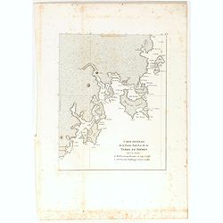
Carte générale de la Partie Sud-Est de la Terre de Diémen . . .
Important map of the south east coastline of Tasmania from South East Cape to Cape Bougainville includes the previous survey by Beautemps-Beaupre together with the later ...
Date: Paris, 1824
Selling price: ????
Please login to see price!
Sold in 2022
![Plan de la Baie Laplace [with] Esquisse du Port Western [with] Plan des Iles Forestier [with] Esquisse du Port Champagny.](/uploads/cache/46372-250x250.jpg)
Plan de la Baie Laplace [with] Esquisse du Port Western [with] Plan des Iles Forestier [with] Esquisse du Port Champagny.
Four maps on one sheet, Laplace Bay, Western Harbour, Forestier islands and Champagny Harbour, from Voyage de découvertes aux terres Australes by François Péron, 1824....
Date: Paris, 1824
Selling price: ????
Please login to see price!
Sold in 2025
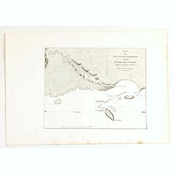
Plan des Iles Louis-Napoléon et de la Rivière des Cygnes.
Map of Louis-Napoléon islands and Swans River, from Voyage de découvertes aux terres Australes by François Péron, 1824. The French expedition under Nicolas Baudin, wa...
Date: Paris, 1824
Selling price: ????
Please login to see price!
Sold in 2020
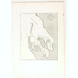
Carte de la Baie des Chiens-Marins. (Shark's Bay)
Map of a portion of the coastline of Western Australia, the Baie des Chiens-Marins, from Voyage de découvertes aux terres Australes by François Péron, 1824. The French...
Date: Paris, 1824
Selling price: ????
Please login to see price!
Sold in 2022
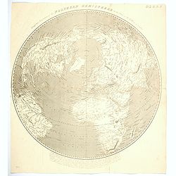
Perspective Projection of the Northern Hemisphere ...
A scarce and unusual hemispherical map, centered on London.
Date: London, 1824
Selling price: ????
Please login to see price!
Sold in 2020