Browse Listings
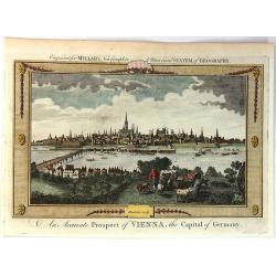
An Accurate Prospect of Vienna, the Capital of Germany.
A fine city view of Vienna, when it was the capital of Germany, not Austria. It is from "Millar's New Complete Universal System of Geography" published in Londo...
Date: London, 1782
Selling price: ????
Please login to see price!
Sold in 2018
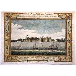
A Prospect of the Castle of Surat, a Great City of Indostan, Commonly called the Mogul Empire in India.
Striking Engraving of the Castle of Surat by John Goldar (1729-1795) for Millar's New Complete and Universal System of Geography dated 1782. The print has a very fancy bo...
Date: London, 1782
Selling price: ????
Please login to see price!
Sold in 2017

(Frontispiece to Millar's New & Universal System of Geography.)
Fine title page showing Neptune and Britannia among several other figures. With lovely details including a globe, a pyramid, fruits, etc.
Date: London, 1782
Selling price: ????
Please login to see price!
Sold in 2017
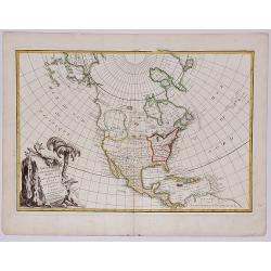
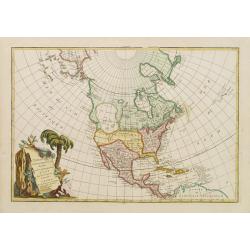
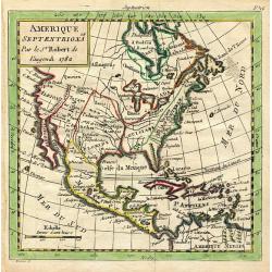
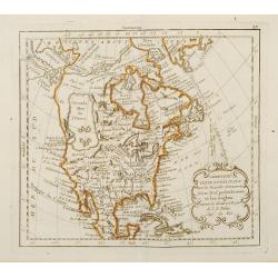
L'AMERIQUE SEPTENTRIONALE divisee en ses principaux Etats.
A fine example of Janvier's map of North America to illustrate the sea of the west "Mer ou Baye de l'Ouest", prior to the incorporation of information from Cook...
Date: Paris, 1782
Selling price: ????
Please login to see price!
Sold in 2017
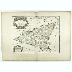
La Sicile divisee en ses trois povinces ou valees. . .
Fine map of Sicily with a decorative title and scale cartouche. The uncommon updated version by Louis Denis, dated 1782.Alexis-Hubert Jaillot (1632-1712), was a French ca...
Date: Paris, 1782
Selling price: ????
Please login to see price!
Sold in 2022
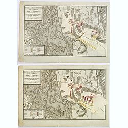
Baitaille d'Altenheim dans l'Ortnau donnee le 1st Aoust 1675. . .
A copperplate folding battle plan of Altenheim, on the east side of the river Rhine. With three pastedown overlays demonstrating the different positions of the French and...
Date: Paris, 1782
Selling price: ????
Please login to see price!
Sold in 2021
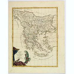
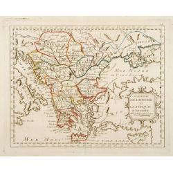
Turchia d'Europa divisa Nelle Sue Provincie, e Governi. . .
The pleasing map of the European provinces of the Ottoman Empire, by Antonio Zatta, published during the latter half of the eighteenth century. It shows the administrativ...
Date: Venice, 1782
Selling price: ????
Please login to see price!
Sold in 2021
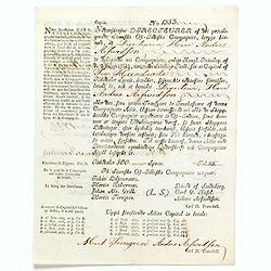
(Very rare share in the Swedish East India Company. ) N° 1353.
Very rare share in Swedish East India Company for Charles Joseph Xavier Knijff of Antwerp for 500 Riksdaelders. With a printed translation in French in the left hand marg...
Date: Gotheborg, 2 May, 1782
Selling price: ????
Please login to see price!
Sold in 2019
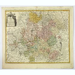
Der Fraenkische Kreis. . .
An attractive large map showing the Frankish Circle in Germany, centered on Bamberg. Each area is highlighted in a different color. With a nice title cartouche, with mile...
Date: Nuremberg, 1782
Selling price: ????
Please login to see price!
Sold in 2019
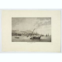
Vue du Port de Scio.
A delightful copperplate view of the port of the Greek island of Chios. It shows fishermen on their boats in the foreground, and the town and surrounding hills in the bac...
Date: Paris, 1782
Selling price: ????
Please login to see price!
Sold in 2019
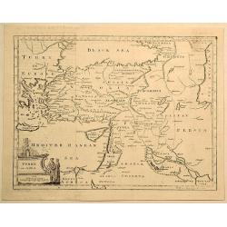
Turkey in Asia.
Original copperplate map by Thomas Jefferys in 1782, engraved by H. Gavin, and published in Thomas Salmon's “The New Universal Geographical Grammar”. Features figura...
Date: London, 1782
Selling price: ????
Please login to see price!
Sold in 2019
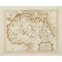
Ducati di Livonia, e di Estonia, e governi di Nowogorod, Bielogorod e Kiowia.
The nice map depicting vast territory of present days Estonia, Latvia, Belarus, Russian Federation and Ukraine. Those days territory belonged to Livonia, Polish-Lithuania...
Date: Venice, 1782
Selling price: ????
Please login to see price!
Sold in 2019
![L'AMERIQUE SEPTENTRIONALE divisee en ses principaux ETATS, 1782.[Great Western Sea]](/uploads/cache/82628-250x250.jpg)
L'AMERIQUE SEPTENTRIONALE divisee en ses principaux ETATS, 1782.[Great Western Sea]
A fine example of Janvier's map of North America to illustrate the sea of the west. "Mer ou Baye de l'Ouest", prior to the incorporation of information from Coo...
Date: Paris, 1782
Selling price: ????
Please login to see price!
Sold in 2019
Li Palatinati di Braclaw e Kiowia. Tratta dall' Atlante Polacco del Sigr Rizzi Zanoni.
An excellent map of the areas of Braclaw (Bratslav), and Kijow (Kiev), west of the Dnieper river. With many place names and a large decorative title vignette.
Date: Venice, ca 1782
Selling price: ????
Please login to see price!
Sold in 2019
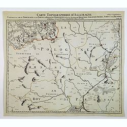
Carte Topographque D'Allemagne / Contenant un reste de Pomeranie et a Partie de la Pologne Prussiene . . .
A large-scale map of Germany and northern Poland, published by the German Military cartographer Johann Wilhelm Abraham Jaeger, from his Grand Atlas d'Allemagne.This map i...
Date: Frankfurt, 1782
Selling price: ????
Please login to see price!
Sold in 2021

Hottentots. / Caffres. (A pair of costume plates of Cape of Good Hope)
Engravings by Poisson after two paintings by Pierre Sonnerat (1748-1814). In the "Caffres" showing a family from what is now South Africa. The term "Kaffir...
Date: 1782
Selling price: ????
Please login to see price!
Sold in 2019
Mappemonde ou carte generale de l`Univers ... avec le tour du monde du Lieut. Cook ...
Full title: 'Mappemonde ou carte generale de l`Univers sur une projection nouvelle d`une sphere ovale pour mieux entendre les distances entre l`Europe et Amerique avec le...
Date: Augsburg, 1782
Selling price: ????
Please login to see price!
Sold in 2020
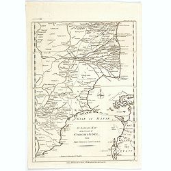
An Accurate Map of the Coast of Coromandel, from Fort St. David to Cape Comorin.
This is a finely engraved map of the south eastern Indian Coromandel coastal regions & the north west Sri Lankan coast through the Gulf of Manar. It was engraved by J...
Date: London, 1782
Selling price: ????
Please login to see price!
Sold in 2021
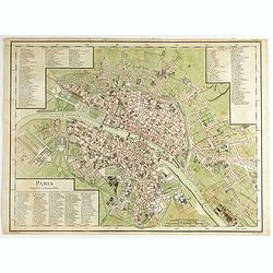
Paris Superficie 5,280,000 Toises.
FIRST EDITION of this finely engraved plan of Paris by P. F. Tardieu and prepared by DuBuisson. This detailed plan of Paris includes la Place Louis XV, la Bastille, but d...
Date: Paris, 1779-1782
Selling price: ????
Please login to see price!
Sold in 2020
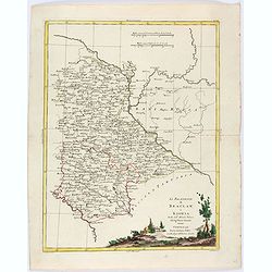
Li Palatinati di Braclaw, e Kiowia tratta dall'Atlante Polacco del Sig. Rizzi Zanoni.
An delightfully engraved map of West central Ukraine, including parts of the modern Oblasts of Kiev, Zhytomyr and Vinnytsia. Województwo Braclawskie, Kijowskie. Publishe...
Date: Venice, 1782
Selling price: ????
Please login to see price!
Sold in 2021
Plano de la Ciudad de Puerto Real, En La Isla De La Jamaica Segun Bontein y la copia de Bellin: Por D. Juan Lopez
This scarce work features a set of four Spanish maps on one sheet depicting Spanish towns and harbor plans of important Jamaican ports.Spanish settlement of Jamaica began...
Date: Madrid, 1782
Selling price: ????
Please login to see price!
Sold in 2023
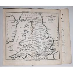
Bowles's Post Chaise Companion; or, Travellers Directory through England and Wales …
The 2nd edition (1782); printed at Carington Bowles, at his Map and Print Warehouse, No. 69, St. Paul's Church Yard, London.The book includes an engraved general map of E...
Date: 1782
Selling price: ????
Please login to see price!
Sold in 2023
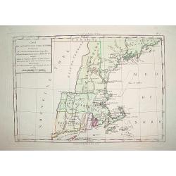
Cart de la Nouvelle Angleterre, Comprenant..
Complete title: ?Cart de la Nouvelle Angleterre, Comprenant les Etats de Massachusetts bay, N. Hamp Shire, Connecticut et Rhode Island?.An extremely scarce map of New Eng...
Date: Paris 1782
Selling price: ????
Please login to see price!
Sold
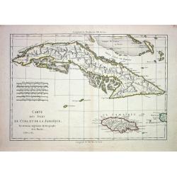
CARTE DES ISLES DE CUBA ET DE LA JAMAIQUE
Very detailed copper-engraved map of Cuba with the southern Bahamas, the Cayman Islands, Jamaica and a small part of Haiti. Many towns are named and some topographical de...
Date: Paris 1782
Selling price: ????
Please login to see price!
Sold
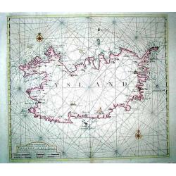
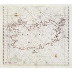
Nieuwe en seer Accurate Paskaart van het Eyland Yslandt In het Groot
Printed in 1782, a scarce original chart of Iceland published by the renowned Amsterdam map and chart publishing dynasty founded by Johannes van Keulen. This chart replac...
Date: Amesterdam (1750) 1782
Selling price: ????
Please login to see price!
Sold
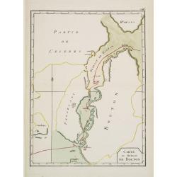
Carte du Détroit de Bouton.
Uncommon map of Celebes centered on the Island of Butung. It shows part of Wowoni Island as well as South East Sulawesi.Indicating a V.OC. Settlement on the island Bouton...
Date: France 1782
Selling price: ????
Please login to see price!
Sold in 2009
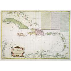
Carte des Isles Antilles dans L\'Amérique Septentrionale avec la majeure partie des Isles Lucayes..
Rare Revolutionary War chart of the the tip of South Florida and the Caribbean, prepared to illustrate a part of the Theatre of War between the English and Americans. Wit...
Date: Paris, 1782
Selling price: ????
Please login to see price!
Sold in 2008
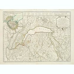
Carte du lac de Genève et des pays circonvoisins..
Map centered on Lake Geneva. In upper left corner inset map of Geneva.Complete title: Carte du lac de Geneve et des pays circonvoisins où se trouvent les frontieres de F...
Date: Paris, 1782
Selling price: ????
Please login to see price!
Sold
L'Amerique Septentrionale divisé en fes principaux.
A finely engraved map of North America, prepared by Janvier. The map is most notable for it's depiction of Mer de L'Quest or Sea of the West, a great sea, easily the size...
Date: Paris 1782
Selling price: ????
Please login to see price!
Sold
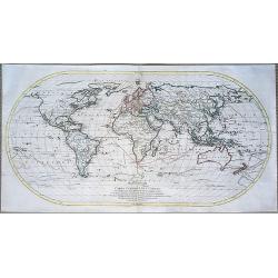
Mappemonde ou Carte Générale de l'Univers...
Important oval shaped map of the world, showing the tracks of Captain Cooks three famous voyages. One of the first world maps to show Hawaii. Early geography of Australi...
Date: Augsburg, 1782
Selling price: ????
Please login to see price!
Sold in 2014
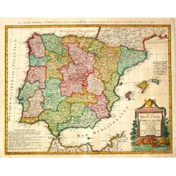
Regnorum Hispaniae et Portugalliae Tabula generalis.
Homann Heirs (of Johann Baptist and Johann Christof) published: Grosser Atlas, 1731, 1737. Geogr. Maior, 1759, Atlas Homannianus, 1762.Lopez?s map of the Iberian peninsul...
Date: Nurnberg, 1782
Selling price: ????
Please login to see price!
Sold

Carte Reduite du globe Terrestre..
Fine world map in a Mercator projection. From Voyages autour du monde et vers les deux pôles par terre et par mer.. by Pierre Marie François vicomte de Pages (1748-1793...
Date: Paris, ca 1782
Selling price: ????
Please login to see price!
Sold
Nieuwe en seer Accurate Paskaart van het Eyland Yslandt In het Groot..
Printed in 1782, a scarce original chart of Iceland published by the renowned Amsterdam map and chart publishing dynasty founded by Johannes van Keulen. This chart replac...
Date: Amesterdam (1750) 1782
Selling price: ????
Please login to see price!
Sold in 2009
Amerique Septentrionale
Charming map of early North America including Central America and the West Indies. Filled with place names, Indian locations, and topographical information such as rivers...
Date: Paris 1782
Selling price: ????
Please login to see price!
Sold in 2008
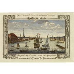
A perspective view of Petersburg, the capital of Russia.
Fine decorative view of St. Petersburg, made for George H. Millar's New and Universal system of Geography , published by Thornton.
Date: London, 1782
Selling price: ????
Please login to see price!
Sold in 2011
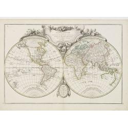
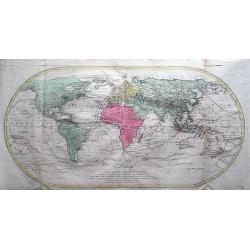
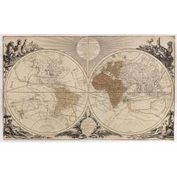
Mappe-Monde ou description du Globe Terrestre..
Attractive double hemisphere world map, surmounted by a finely engraved and elaborate title piece. A good example of elegant French cartography. This edition dated 1782.
Date: Paris, 1782
Selling price: ????
Please login to see price!
Sold in 2011
Carte d\'une partie de l\'Amerique.. et de la Louisiane..
A handsome and seldom-seen map of the Spanish colonial period. Included in Voyages de Mr. de Pagés.De Pages, a French nobleman and Navy captain, crossed the \"Provi...
Date: Paris, 1782
Selling price: ????
Please login to see price!
Sold in 2008
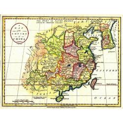
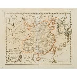
A Map of the Empire of China.
Map showing China, Formosa, and Korea. The map is of interest for the use of East Sea, the sea between Korea and Japan, here called "Sea of Korea". Uncommon map...
Date: London, 1782
Selling price: ????
Please login to see price!
Sold in 2011
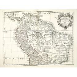
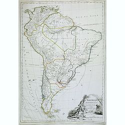
Carte de la Terre Ferme du Perou du Bresil et du Pays des Amazones.
A later issue of this detailed and surprisingly accurate map of the northern part of South America prepared by De l'Isle. It is filled with place names and notations spec...
Date: Paris, 1782
Selling price: ????
Please login to see price!
Sold in 2021
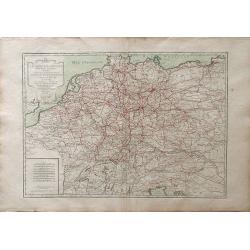
L\'Empire d\'Allemagne divise en fes principaux Etats, ou font exactement remarquees Toutes Les Routes des Postes et Chariots de Poste de L\'Empire
A fine map of the German empire of north and central Europe, showing the areas of northwestern France, Belgium, Netherlands, northern Italy, Switzerland, Luxembourg, Aust...
Date: Paris, 1782
Selling price: ????
Please login to see price!
Sold in 2010
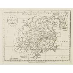
A map of the Empire of China.
Map showing China, Formosa and Corea.The map is of interest for the use of East Sea, the sea between Korea and Japan, here called "Sea of Korea".Uncommon map en...
Date: London, 1782
Selling price: ????
Please login to see price!
Sold in 2010
Mappe-Monde géo-hydrographique ou description génerale du globe. . . Des nouvelles découvertes, faites par . . . Cook, Bougainville . . .
World in two hemispheres, showing Tasmania still joined to Australia's main land. With a color key in bottom to the voyages of Cook, Clarke, Fourneaux, Bougainville, Yves...
Date: Paris, 1782
Selling price: ????
Please login to see price!
Sold in 2011
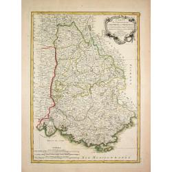
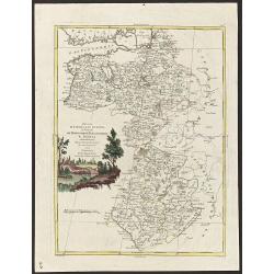
Carte des Gouvernements de Dauphine et de Provence.
Jean Lattré, Paris-based engraver and publisher. Worked with Robert de Vaugondy, J. Janvier and R. Bonne. " Atlas Monderne', 1771, 1783 , 1793. Rigobert Bonne (1727...
Date: Paris, 1783
Selling price: ????
Please login to see price!
Sold
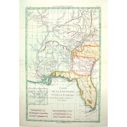
Carte de la Louisinae, et de Floride.
A handsome map of the American Southeast, including the Mississippi River Valley. The work covers from Charleston, South Carolina, extending west past New Orleans and nor...
Date: ca.1783
Selling price: ????
Please login to see price!
Sold
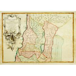
TERRAE SANCTAE TABULA e scripturae sacrae?
Map of the Holy Land on both sides of the Jordan, divided among the Tribes and according to the division into provinces at the Roman time. The shore line runs from Sidon ...
Date: Paris 1771-1783
Selling price: ????
Please login to see price!
Sold
L' Amerique divisee par grands Etats.
Jean Lattré, Paris-based engraver and publisher. Worked with Robert de Vaugondy, J. Janvier and R. Bonne. "" Atlas Monderne', 1771, 1783 , 1793. Jean Janvier, ...
Date: Paris, 1783
Selling price: ????
Please login to see price!
Sold

Le Basset A Jambes Torses.
A charming plate from "Histoire Naturelle, Générale et Particulière," Georges Louis Marie Leclerc, comte de Buffon's magnum opus and "the most celebrate...
Date: Paris: Imprimerie Royale, 1749-1783
Selling price: ????
Please login to see price!
Sold in 2022
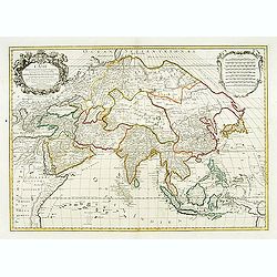
L'Asie divisée en ses principales régions..
Detailed map of Asia. After Sanson and Jaillot but updated by Brion de la Tour, in 1783. Louis Brion de la Tour was a military engineer and Geographer to the King.
Date: Paris, 1783
Selling price: ????
Please login to see price!
Sold
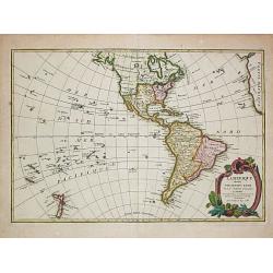
L'Amérique méridionale.
Map of South America embellished with a figurative title cartouche.
Date: Paris, 1783
Selling price: ????
Please login to see price!
Sold in 2020
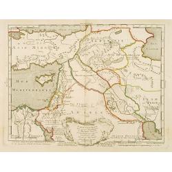
Carte générale pour servir à l'Intelligence de l'Histoire Sainte..
Fine map of the Middle East, including the Holy Land, Cyprus, Iran and Irak, etc.Philippe Buache was one of the most active proponents of the so-called school of theoreti...
Date: Paris 1783
Selling price: ????
Please login to see price!
Sold

De la Sphère..
Rare print of armillary sphere, surrounded by several diagrams of the sun, moon, and planets after Cassini. In lower part 9 blocks of text with explanations. From Atlas G...
Date: Paris, 1783
Selling price: ????
Please login to see price!
Sold in 2008
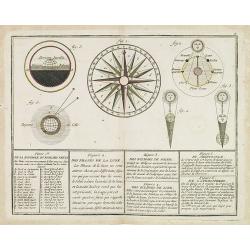
De la Boussole ou Rose des Vents / Des Phases de la Lune. / Des Eclipses de Soleil. / Des Eclipse de Lune. / Du Crépuscule. / De l'Atmosphère.
A compass-rose, surrounded by 5 solar systems published by Monhare for his Atlas Général a l'usage des colleges et maisons d'education..
Date: Paris 1783
Selling price: ????
Please login to see price!
Sold in 2019
![Hémisphère Oriental ou Ancien Monde. [2 sheets]](/uploads/cache/17189-250x250.jpg)
Hémisphère Oriental ou Ancien Monde. [2 sheets]
Two sheet, together a world map in double hemisphere published by Monhare for his Atlas Général a l'usage des colleges et maisons d'education.. The hemispheres are surr...
Date: Paris, 1783
Selling price: ????
Please login to see price!
Sold in 2020
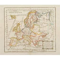
L\'Europe Divisée Suivant ses principaux Etats ..
Map of Europe prepared by de La Fosse and published by Monhare for his Atlas Général a l\'usage des colleges et maisons d\'education.. Louis Joseph Mondhare published s...
Date: Paris, 1783
Selling price: ????
Please login to see price!
Sold in 2009
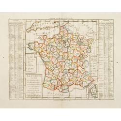
La France Divisée en IX Régions, 10 Métropoles, et 85 Départements ..
Rare map of France prepared after J.B.Nolin and published by Monhare for his Atlas Général a l'usage des colleges et maisons d'education.. Lower right inset map of Cors...
Date: Paris 1783
Selling price: ????
Please login to see price!
Sold
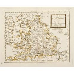
Carte du Royaume de l'Angleterre divisé par Provinces, Schires ou Comtés ..
Rare map of England prepared after J.B.Nolin and published by Monhare for his Atlas Général a l'usage des colleges et maisons d'education.. Louis Joseph Mondhare publis...
Date: Paris 1783
Selling price: ????
Please login to see price!
Sold
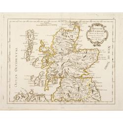
Royaume d'Ecosse Divisé en Provinces . . .
Rare map of Scotland prepared by J.B.Nolin and published by Monhare for his Atlas Général a l'usage des colleges et maisons d'education.. Louis Joseph Mondhare publishe...
Date: Paris, 1783
Selling price: ????
Please login to see price!
Sold in 2016
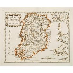
Isle et Royaume D'Irlande ..
Rare map of Ireland prepared by J.B.Nolin and published by Monhare for his Atlas Général a l'usage des colleges et maisons d'education.. Louis Joseph Mondhare published...
Date: Paris 1783
Selling price: ????
Please login to see price!
Sold
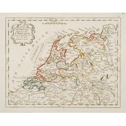
Carte des Provinces Unies Des Pays-Bas connüe sous le nom D'Hollande ..
Rare map of the Netherlands prepared by J.B.Nolin and published by Monhare for his Atlas Général a l'usage des colleges et maisons d'education.. Louis Joseph Mondhare p...
Date: Paris, 1783
Selling price: ????
Please login to see price!
Sold in 2022
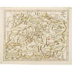
Carte de la Suisses des Alliés des Suisses et de leurs Sujets ..
Rare map of Switzerland prepared by J.B.Nolin and published by Monhare for his Atlas Général a l'usage des colleges et maisons d'education.. Louis Joseph Mondhare publi...
Date: Paris, 1783
Selling price: ????
Please login to see price!
Sold in 2013
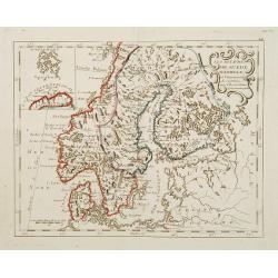
Les Royaumes De Suede Norwege et Danemark ..
Rare map of Scandinavia prepared by J.B.Nolin and published by Monhare for his Atlas Général a l'usage des colleges et maisons d'education.. With inset map of Lapland a...
Date: Paris, 1783
Selling price: ????
Please login to see price!
Sold in 2009
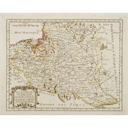
Etats de la Couronne de Pologne ousont les Roy de Pologne, le Gd. Duc de Lithuanie, La Russie noire, La Volhinie?
Rare map of Poland prepared by J.B.Nolin and published by Monhare for his Atlas Général a l'usage des colleges et maisons d'education.. Louis Joseph Mondhare published ...
Date: Paris, 1783
Selling price: ????
Please login to see price!
Sold
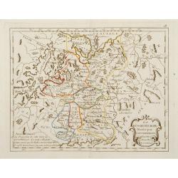
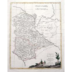
La Russie d'Europe Divisée par Gouvernemens Assujetties aux Nouvelles Observations..
Rare map of the European part of Russia, prepared by J.B.Nolin and published by Monhare for his Atlas Général a l'usage des colleges et maisons d'ed...
Date: Paris, 1783
Selling price: ????
Please login to see price!
Sold in 2009
Le Royaume de Hongrie et la Turquie d'Europe ..
Rare map of Greece and Hungary prepared by J.B.Nolin and published by Monhare for his Atlas Général a l'usage des colleges et maisons d'education.. Louis Joseph Mondhar...
Date: Paris, 1783
Selling price: ????
Please login to see price!
Sold
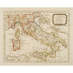
L'Italie Divisée en ses différents Etats Royaume et Républiques..
Rare map of Italy, prepared by J.B.Nolin and published by Monhare for his Atlas Général a l'usage des colleges et maisons d'education.. Louis Joseph Mondhare published ...
Date: Paris, 1783
Selling price: ????
Please login to see price!
Sold
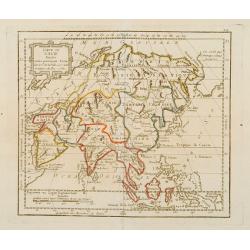
Carte de l'Asie Divisée entre Ses principaux Etats ..
Rare map of Asia, dated 1780 prepared by de la Fosse and J.B.Nolin, published by Monhare for his Atlas Général a l'usage des colleges et maisons d'education.. Louis Jos...
Date: Paris, 1783
Selling price: ????
Please login to see price!
Sold in 2009
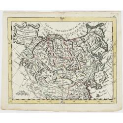
Carte Générale de l'Empire des Russes et de la Tartarie Universelle.
Rare map of Tartary and Russia, including Korea and Japan prepared after J.B.Nolin and published by Monhare for his Atlas Général a l'usage des colleges et maisons d'ed...
Date: Paris, 1783
Selling price: ????
Please login to see price!
Sold in 2023
L'Empire de la Chine Avec les Isles Du Japon et la Coree ..
Rare map of China, including Korea, Taiwan and southern part of Japan, prepared after J.B.Nolin and published by Monhare for his Atlas Général a l'usage des colleges et...
Date: Paris, 1783
Selling price: ????
Please login to see price!
Sold
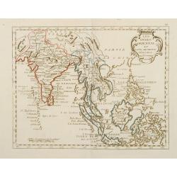
Les Indes Oriental et Leur Archipels Assujetties..
Rare map of India and South East Asia prepared after J.B.Nolin and published by Monhare for his Atlas Général a l'usage des colleges et maisons d'education.. Louis Jose...
Date: Paris, 1783
Selling price: ????
Please login to see price!
Sold
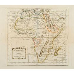
L'Afrique Suivant les dernier Mémoires de J.B.Nolin..
Rare map of the continent of Africa prepared after J.B.Nolin and published by Monhare for his Atlas Général a l'usage des colleges et maisons d'education.. Louis Joseph...
Date: Paris, 1783
Selling price: ????
Please login to see price!
Sold
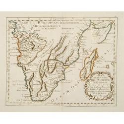
Partie Méridionale de l'Afrique Ou se trouvent le Congo la Cafrerie le Cap de Bonne Espérance et la Côte de Zanguébar..
A rare map depicts Southern Africa from Mombasa on the east coast south to the Cape, and Isle St. Thomas on the west side, at the Equator southward to approximately 35deg...
Date: Paris, 1783
Selling price: ????
Please login to see price!
Sold
Partie Septentrionale de l'Afrique, Contenant l'Egipte, Nubie, l'Abissinie, la Barbarie Nigritie et la Guinée..
Rare map of the northern part of Africa, including Canaries. After J.B.Nolin and published by Monhare for his Atlas Général a l'usage des colleges et maisons d'educatio...
Date: Paris, 1783
Selling price: ????
Please login to see price!
Sold in 2009
Amérique Septentrionale avec les Nouvelles Découvertes fait au Nord, par les Russes et les Anglois..
Rare map of North America, showing a remarkable NW Coast of America, including the recently discovered sea (by the Russians) of the West. The NW Coast and area near Canad...
Date: Paris, 1783
Selling price: ????
Please login to see price!
Sold
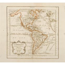
L'Amérique Suivant les dernier Mémoires de J.B.Nolin..
Map of the Western Hemispher after J.B.Nolin and published by Monhare for his Atlas Général a l'usage des colleges et maisons d'education.. Louis Joseph Mondhare publis...
Date: Paris, 1783
Selling price: ????
Please login to see price!
Sold in 2010
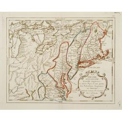
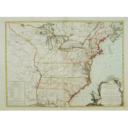
La Virginie, Pennsilvanie, Nouvelle Angleterre, et autres Pays fesant partie des Possessions Angloises, en Amérique..
Rare map, extending from Maine to the Chesapeake and west to include Lake Michigan. A boundary line confines the English colonies to the coast. F. Duquene is named along ...
Date: Paris, 1783
Selling price: ????
Please login to see price!
Sold
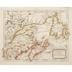
Partie Septentrional des Possessions Angloise En Amérique ou se trouvent l\'Isle de Terre-Neuve le Canada et la Nouvelle Ecosse.
Rare map of eastern Canada, showing the are from Montreal, Lake Champlain till New Foundland.The map is filled with place names, Indian villages, early forts, french garr...
Date: Paris, 1783
Selling price: ????
Please login to see price!
Sold in 2008
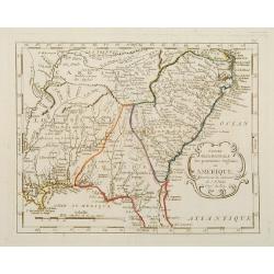
Partie Méridionale des possessions Angloises en Amérique..
Rare map of the South, showing the regions east of the Mississippi and extending North to Virginia and Kentucky. The map is filled with place names, Indian villlages, ear...
Date: Paris, 1783
Selling price: ????
Please login to see price!
Sold
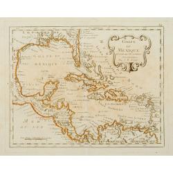
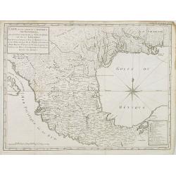
Golfe du Mexique Assujetti aux Observations Astronomiques Par J.B.Nolin.
Rare map of the Caribbean prepared by J.B.Nolin and published by Monhare for his Atlas Général a l'usage des colleges et maisons d'education.. Florida is filled with a ...
Date: Paris, 1783
Selling price: ????
Please login to see price!
Sold
![[Title page] Atlas Général A l'Usage des Collèges Et Maisons d'Education Adapté aux Différents ouvrages de Géographie?](/uploads/cache/17233-250x250.jpg)
[Title page] Atlas Général A l'Usage des Collèges Et Maisons d'Education Adapté aux Différents ouvrages de Géographie?
Rare title page published by Monhare for his Atlas Général a l'usage des colleges et maisons d'education.. Louis Joseph Mondhare published several smaller atlases and r...
Date: Paris, 1783
Selling price: ????
Please login to see price!
Sold
CARTE DES ETATS-UNIS D'AMÉRIQUE, et du Cours du Mississipi..
First state of three with changed date and imprint. It was first published in 1783 by Desnos, then by Esnauts et Rapilly and was re-issued in 1787. This map composed by B...
Date: Paris 1783
Selling price: ????
Please login to see price!
Sold