Browse Listings
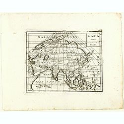
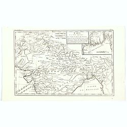
L'Asia divisa ne' suoi principali stati.
Rare map of Asia, from "Atlante Novissimo ad uso Dei Giovani Studiosi Contenuto In Carte XXVII.", published by Giovanni Zempel in Rome, ca. 1780.The map is base...
Date: Rome, 1780
Selling price: ????
Please login to see price!
Sold in 2018
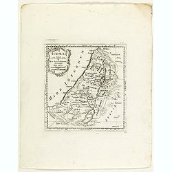
Iudaea.
Rare map of Holy Land, from "Atlante Novissimo ad uso Dei Giovani Studiosi Contenuto In Carte XXVII.", published by Giovanni Zempel in Rome, ca. 1780.The map is...
Date: Rome, 1780
Selling price: ????
Please login to see price!
Sold in 2018
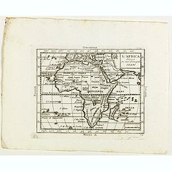
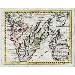
L'Africa divisa ne' suoi principal stati.
Rare map of Africa, with Madagascar and Arabia, from "Atlante Novissimo ad uso Dei Giovani Studiosi Contenuto In Carte XXVII.", published by Giovanni Zempel in ...
Date: Rome, 1780
Selling price: ????
Please login to see price!
Sold in 2018
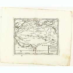
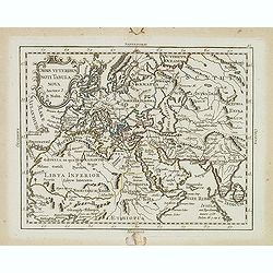
Barbaria, Egitto, Nigrizia, Guinea, Nubia Abissina.
Rare map of the northern half of Africa, from "Atlante Novissimo ad uso Dei Giovani Studiosi Contenuto In Carte XXVII.", published by Giovanni Zempel in Rome, c...
Date: Rome, 1780
Selling price: ????
Please login to see price!
Sold in 2021
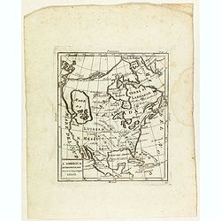
L'America settentrionale divisa ne' suoi principali stati.
Rare map of North America, from "Atlante Novissimo ad uso Dei Giovani Studiosi Contenuto In Carte XXVII.", published by Giovanni Zempel in Rome, ca. 1780.The ma...
Date: Rome, 1780
Selling price: ????
Please login to see price!
Sold in 2019
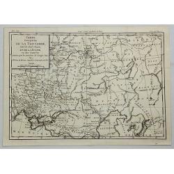
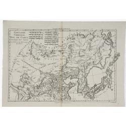
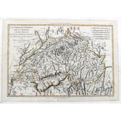
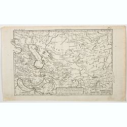
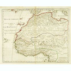
Carte d'Une Partie de la Tartarie Vers le sud Ouest et de la Russie ou des Contrees & Carte de la PARTIE Meridionale de la Tartarie.
[TWO MAPS] A striking pair of matching maps of Tartary covering the area (a) between Turkey and Kirgisi and from Siberia to the Caspian sea, and (b) the area between Indo...
Date: Paris, 1780
Selling price: ????
Please login to see price!
Sold in 2021
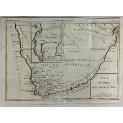
Carte du Pays des Hottentots.
A fine engraved map of The Cape of Good Hope in South Africa.It includes an inset of False Bay. Published in 1780 by Louis Brion de la Tour. Louis Brion de la Tour, (174...
Date: Paris, 1780
Selling price: ????
Please login to see price!
Sold in 2018
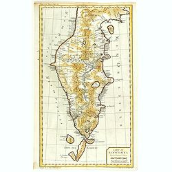
Carte du Kamtchakta Dressée et Gravée par Laurent. . .
An early detailed map of the Kamchatka peninsula, based on the work of Stepan Petrovich Krasheninnikov, who travelled in the area 1737-1741.Drawn and engraved by Laurent ...
Date: Paris, 1757 - 1780
Selling price: ????
Please login to see price!
Sold in 2018
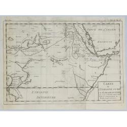
Carte de L'Ethiopie et de la Garamandtide.
A nice map of the Horn of Africa, including Ethiopia, Djibouti, Eritra and Sudan, by Brion de la Tour in Paris in 1780.Louis Brion de la Tour, (1743 –1803) was an 18th-...
Date: Paris, 1780
Selling price: ????
Please login to see price!
Sold in 2019
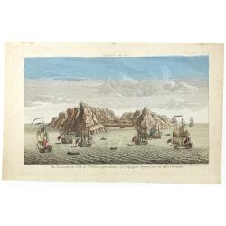
Vue perpective de l'Isle de St.Helene appartenant a la Compagnie Angloise pour les Indes Orientales.
Decorative optical view of St. Helena.
Date: Paris, 1780
Selling price: ????
Please login to see price!
Sold in 2018
Plan de Gibraltar attaqué par terre et par mer par l'armee espagnole et francaise aux ordres de M. le duc de Crillon, en presence de Mgr le duc d'Artois, d'apres les dessins d'un ingenieur en chef de l'armee. . .
A separately published map of Gibraltar, on the very tip of the Iberian Peninsula, includes a wealth of information about positions of French battle ships concerning the ...
Date: Paris, ca 1780
Selling price: ????
Please login to see price!
Sold in 2018
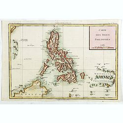
Carte des Isles Philippines.
Detailed map of Philippines, published by Louis Brion de la Tour. From the 'Histoire Universel'.More about maps of the Philippines. [+]
Date: Paris, c.1780
Selling price: ????
Please login to see price!
Sold in 2019
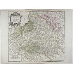
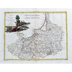
Le Royaume de Pologne, divise en ses duches et Provinces, et subdivise en Palatinats.
This is a fine map of the Kingdom of Poland by Robert de Vaugondy. It depicts the different Palantinates or administrative division of Poland and Lithuania as well as par...
Date: Paris, 1780
Selling price: ????
Please login to see price!
Sold in 2019
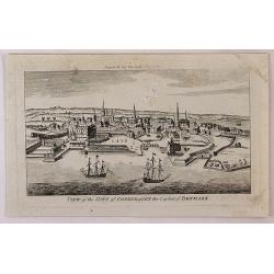
View of the City of Copenhagen, the Capital of Denmark.
A fine panoramic city view map of Copenhagen, Denmark. It features detailed sailing ships in the foreground. From "THE LADY'S MAGAZINE", published monthly in Lo...
Date: London, 1780
Selling price: ????
Please login to see price!
Sold in 2018
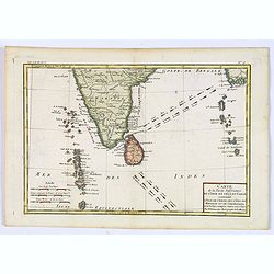
![[Untitled] English Sea Chart.](/uploads/cache/42898-250x250.jpg)
[Untitled] English Sea Chart.
A large, English Sea Chart of southern India, the Maldives (and other) Islands, and the island of 'Zeloan' (Sri Lanka). The interiors are almost bare of any information w...
Date: Anon, ca 1780
Selling price: ????
Please login to see price!
Sold in 2018
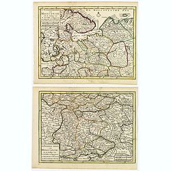
(2 maps) 'T Noorderdeel van Moscovie / T Zuider-Deel van Moscovie.
A nice pair of Russian maps detailing the regions from Moscow south to the Black Sea and the Sea of Azof, and from north of Moscow to the White Sea and Russian Lappland. ...
Date: Deventer, ca 1780
Selling price: ????
Please login to see price!
Sold in 2019
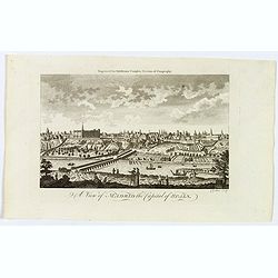
A View of Madrid the Capital of Spain.
A detailed and attractive copperplate perspective view of Madrid, published in London for Middleton's Complete System of Geography. Shows figures in the foreground, pleas...
Date: London, ca 1780
Selling price: ????
Please login to see price!
Sold in 2019
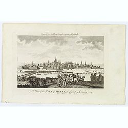
A View of the City of Vienna the Capitol of Germany.
A detailed and attractive copperplate perspective view of the walled city of Vienna, the capitol of the Austro-Hungarian Empire, published in London for Middleton's Compl...
Date: London, ca 1780
Selling price: ????
Please login to see price!
Sold in 2020
![Carte de la côte N[ord] O[uest]. de l'Amérique et de la côte N. E. de l'Asie reconnues en 1778 et 1779. . .](/uploads/cache/43766-250x250.jpg)
Carte de la côte N[ord] O[uest]. de l'Amérique et de la côte N. E. de l'Asie reconnues en 1778 et 1779. . .
A map of the north Pacific with Alaska, engraved by André. With inset map "Plan de l'Entrée de Nootka. . ." This is the general map of the northwest coast fro...
Date: Paris, ca 1780
Selling price: ????
Please login to see price!
Sold in 2020
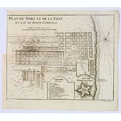
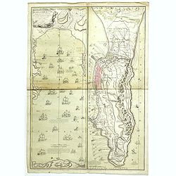
Plan du Fort et de la ville du Cap de Bonne Esperance.
Plan of the city, the fort and Good Hope Cape. With an explanation key to a list of 13 important sites and locations keyed to the plan with corresponding letters. Shows a...
Date: Paris, ca 1780
Selling price: ????
Please login to see price!
Sold in 2020
Carte de la Partie Inferieure de l'Inde en Deca du Gange. . .
A late eighteenth century map of southern India by the French cartographer Rigobert Bonne. Shows the southern coasts of Malabar and Coromandel. Map extent is from the Dec...
Date: Paris, 1780
Selling price: ????
Please login to see price!
Sold in 2020
Europa veteribus nota. L'Europe Ancienne.
Rarely seen map of ancient Europe. Filled with old names and details. Text panel to the left. With a decorative title cartouche. Engraved by Moithey and Herault.
Date: Paris, ca. 1780
Selling price: ????
Please login to see price!
Sold in 2019
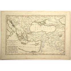
La Turquie d'europe et Celle d'Asie.
Fine example of Bonne’s 1780 map of Turkey in Europe and Asia. This map of the Ottoman Empire includes the areas stretching from Italy, Hungary, and modern day Austria ...
Date: Paris, 1780
Selling price: ????
Please login to see price!
Sold in 2019
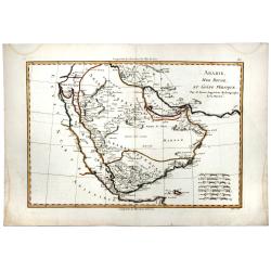
ARABIE, MER ROUGE, ET GOLFE PERSIQUE.
A detailed map of Saudi Arabia, the Red Sea, Persian Gulf and more. With mostly coastal information, interior largely left blank. Sets of mileage scales.
Date: Paris, 1780
Selling price: ????
Please login to see price!
Sold in 2020
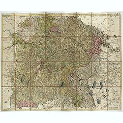
Il Circolo della Bassa Sassonia divisio ne Suoi Stati. . .
An attractive map of Lower Saxony by Antonio Zatta, from the Atlante Novissimo atlas. The map is engraved with great care and skill, and is embellished with a lovely larg...
Date: Venice, 1780
Selling price: ????
Please login to see price!
Sold in 2021
Carta Della Florida, Luigiana e Laghi del Canada.
A scarce Italian map of the United States, Florida, Louisiana and Canada, probably issued during the American Revolutionary War. The eastern US is called 'Province Unite'...
Date: Venice, ca 1780
Selling price: ????
Please login to see price!
Sold in 2020
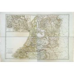
Province-Unies en 4 Feuilles.
Rare wall map sized map in 4 sheets of the Netherlands, with inset map of a large part of Zeeland. Finely engraved and highly detailed and complete map on thick paper. Ve...
Date: Paris, 1780
Selling price: ????
Please login to see price!
Sold in 2020
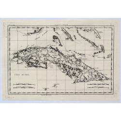
L'Isle de Cuba.
A highly detailed map of Cuba. Also shows a portion of the Bahamas and the Cayman Islands. By Bonne & Raynal in Paris in 1780.Rigobert Bonne (1727-1794) was an influ...
Date: Paris, 1780
Selling price: ????
Please login to see price!
Sold in 2021

Vue Perspective de L'Entrée du Parc du Prince de Manheim en Allemagne.
A perspective view of the Royal Park in Manheim by Basset, a well-known publisher of optical prints, established in rue St.Jacques in Paris. In the eighteenth and ninetee...
Date: Paris, 1780
Selling price: ????
Please login to see price!
Sold in 2023
Tartarie Chinoise, Roy, de Coree et Isles du Japon.
A detailed map of Japan, Korea, Manchuria and the Gobi Desert. Highly detailed. From Bonne's Atlas Encyclopedique.Rigobert Bonne (1727-1794) was an influential French ca...
Date: Paris, 1780
Selling price: ????
Please login to see price!
Sold in 2019
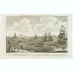
A View of the Whale-Fishery, and the manner of Killing-Bears near the Coast of Greenland.
A well engraved late eighteenth century copperplate showing a number of ships and about a dozen longboat, most with men harpooning whales. Icebergs nearby float in the se...
Date: London, ca 1780
Selling price: ????
Please login to see price!
Sold in 2019
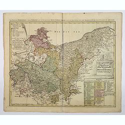
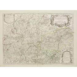
Der nordliche Theil des Obersachsischen Kreises oder die Mark Brandenburg und das Herzogthum Pommern.
A detailed map of the upper Saxon circle with Brandenbourg, Pommern, in Germany. Complete with a table of notes and explanations, and a scroll cartouche containing the me...
Date: Nuremberg, ca 1780
Selling price: ????
Please login to see price!
Sold in 2021
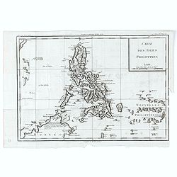
Carte des Isles Philippines.
Detailed map of Philippines, published by Louis Brion de la Tour. From the 'Histoire Universel'.More about maps of the Philippines. [+]
Date: Paris, c.1780
Selling price: ????
Please login to see price!
Sold in 2020
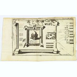
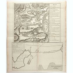
Madirass. Ville Indienne don't les Maisons sont basses & plates.
A small plan of Fort St. George, Madras/Chennai in India. It highlights both inner and outer fortifications, fences, town entrances and the sea, together with the church,...
Date: Unknown, ca 1780
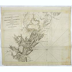
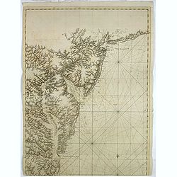
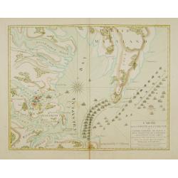
The coast, rivers and inlets of the Province of Georgia surveyed by Joseph Avery and others. . .
Chart of part of the Eastern Seaboard of the USA, with Port Royal Sound, the Savannah River, Warsaw Inlet (Wassaw Sound), Osebaw Inlet (Ossabaw Sound) and St Catherine's ...
Date: London, 1780
Selling price: ????
Please login to see price!
Sold in 2019
A chart of the coast of New York, New Jersey, Pensilvania, Maryland, Virginia, North Carolina, & c. . . .
A chart of A chart of the coast of New York, New Jersey, Pennsylvania, Maryland, Virginia, North Carolina, & c., taken from the "Atlantic Neptune", and mark...
Date: London, 1780
Selling price: ????
Please login to see price!
Sold in 2019
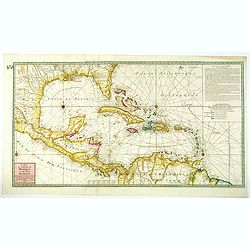
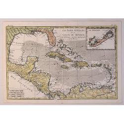
Carte du Golphe du Mexique et des Isles Antilles reduite de la grande Carte Anglois de Popple.
A good example of the 1780 Dezauche edition of Buache's most important map of the West Indies. Centered primarily on Cuba, this substantial map covers all of Central Amer...
Date: Paris, 1780
Selling price: ????
Please login to see price!
Sold in 2021
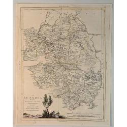
La Lusanzia Divisa Nesuoi Stati di Nouva Projezione.
A fine detailed map of Lustia, Poland and Germany by Zatta in 1790. It features a pleasing hand-colored cartouche.Antonio Zatta (1775-1797) was the most prominent Italian...
Date: Venice, 1780
Selling price: ????
Please login to see price!
Sold in 2020
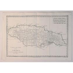
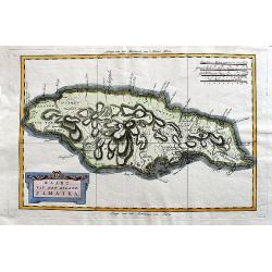
Carte de L'Isle de la Jamaique.
A fine example of Rigobert Bonne and Guilleme Raynal's 1780 map of Jamaica. Highly detailed, showing towns, rivers, some topographical features, political boundaries and ...
Date: Paris, 1780
Selling price: ????
Please login to see price!
Sold in 2020
Les Isles Antilles et le Golfe du Mexique.
A fine Bonne / Raynal's 1780 highly desirable map of the West Indies, Gulf of Mexico, Antilles, and Caribbean. The map extends from Florida to the Spanish Main and from M...
Date: Paris, 1780
Selling price: ????
Please login to see price!
Sold in 2021
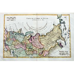
Carte de l'empire de Russie en Europe et en Asie.
An interesting 18th century map of Russia, from the Black Sea until Alaska. Shows major towns, regions, rivers, and mountains. Also curious islands in the northern Pacifi...
Date: Paris, ca. 1780
Selling price: ????
Please login to see price!
Sold in 2020
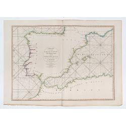
A Chart of the Coasts of Spain and Portugal, with the Balearic Islands, and Part of the Coast of Barbary.
Double page chart of the seas surrounding Spain and Portugal.
Date: London, 1780
Selling price: ????
Please login to see price!
Sold in 2023
Kaart van het eiland Jamaika.
An uncommon and very attractive Dutch map of Jamaica. The island's mountains are boldly engraved and there is excellent detail of the various river systems provided. The ...
Date: Amsterdam, ca 1780
Selling price: ????
Please login to see price!
Sold in 2020
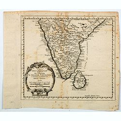
Carta Dell' Indostan che comprende il Malabar, Coromandel, e tutta la penisola Dell' India.
This is from a scarce Italian edition of French cartographer Jacques-Nicholas Bellin’s map of southern India and the island of Ceylon (Sri Lanka). The map extent is fro...
Date: Paris, ca 1780
Selling price: ????
Please login to see price!
Sold in 2021

Vue Perspective du Palais du Duc d'Aveiro a Lisbonne.
Perspective view of the Palace of the Duke of Aveiro in Lisbon. A well-known publisher of optical prints, established in rue St.Martin in Paris.In the eighteenth and nine...
Date: Paris, 1780
Selling price: ????
Please login to see price!
Sold in 2021
Bataille de Stavoutschan
Shows the battle of Stavutschan during the Russo-Austrian Turkish War (1736-39). Right legend of A-V. Taken from Chr. H. v. Manstein, "Mémoires historiques, polit...
Date: Paris, c.1780
Selling price: ????
Please login to see price!
Sold in 2020
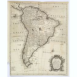
A Map of South America, With all the European Settlements. . .
A pleasant map of South America, showing great detail along the west coast, and the east coast of Brazil, however, the vast interior of Brazil and the Amazon is labelled ...
Date: London, 1780
Selling price: ????
Please login to see price!
Sold in 2020
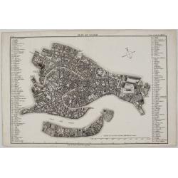
Plan de Venise.
A rare and extremely detailed plan of the city of Venice, Italy. Plazas, streets, fountains, public places, antiquities, schools and notable palaces are all identified by...
Date: Paris, 1780
Selling price: ????
Please login to see price!
Sold in 2020
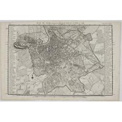
Plan de Rome. . .
A rare and extremely detailed plan of the city of Rome, Italy. This map is a reduced version of J. B. Nolli’s famous 1748, 12 sheet map of Rome. It includes; Plazas, st...
Date: Paris, 1780
Selling price: ????
Please login to see price!
Sold in 2020
Carte de la Partie Superieure de L'Indie en de ca du Gange. . .
Rigobert Bonne (1727-1795), French cartographer. His maps are found in the 'Atlas Moderne' (1762), Raynal's 'Histoire Philos. du Commerce des Indes' (1774) and 'Atlas Enc...
Date: Paris, 1780
Selling price: ????
Please login to see price!
Sold in 2020
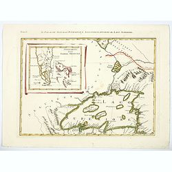
Il Paese de Selvaggi Outauacesi e Kilistinesi Intorno al Lago Superiore.
This is one sheet from Antonio Zatta's version of John Mitchell's epic map. The whole map was titled "Le Colonie Unite dell' America Settentrle" and was publish...
Date: Venice, 1780
Selling price: ????
Please login to see price!
Sold in 2020
![[Vue d'optique] Le Profil du Palais de Petersbourg.](/uploads/cache/46763-250x250.jpg)
[Vue d'optique] Le Profil du Palais de Petersbourg.
A delightful late eighteenth century (partial) view of the Palace of St. Petersburg in Russia. Some 'well to do' locals are seen strolling among its many columns, all obs...
Date: Paris, ca 1780
Selling price: ????
Please login to see price!
Sold in 2020
Das Herzogthum Ober und Nieder Baiern in seine Aemter oder Gerichter eingetheilt, nebst allen darinn liegenden und angrænzenden Lændern / Neu in 4 Blatt herausgegeben von Gebrüder Lotter in Augsburg
Folding map of The Duchy of Upper and Lower Bavaria. Including Regensburg, München, Salzburg in Austria. In very attractive colors.More about folding maps. [+]
Date: Augsburg, 1780
Selling price: ????
Please login to see price!
Sold in 2021
![Le Kaire [Cairo.]](/uploads/cache/85334-250x250.jpg)
Le Kaire [Cairo.]
A very strong fine view of Cairo. Many pleasure boats are seen in the foreground, and many fine buildings front the shoreline. An attractive 'busy' print.
Date: Paris, ca 1780
Selling price: ????
Please login to see price!
Sold in 2021
Les Treize Cantons de la Suisse, leurs allies, les sujets de ces Cantons; et ceux de leurs allies.
Attractive map with decorative coloring. Published in an atlas by Rigobert Bonne, engraved by André. Shows Switzerland and its bordering areas. Including parts of north...
Date: Paris, 1780
Selling price: ????
Please login to see price!
Sold in 2021
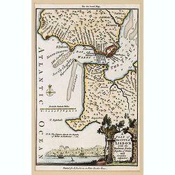
A Plan of the City of Lisbon with the Harbour, Forts, Depths of Water and Country adjacent.
A lovely small plan of the city and immediate surrounds of the Portuguese capitol, complete with a mileage scale, compass rose and a decorative title vignette in the lowe...
Date: London, ca 1780
Selling price: ????
Please login to see price!
Sold in 2021
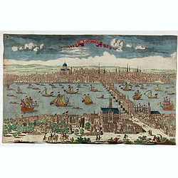
Londres.
Decorative print of London.
Date: Paris, ca. 1780
Selling price: ????
Please login to see price!
Sold in 2022
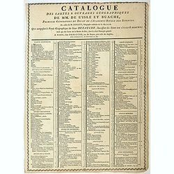
Catalogue des cartes & ouvrages geographiques de MM. DE L'ISLE ET BUACHE
Broad side sheet with on both side a listing of the geographical works of Buache. The sheet also lists the prices of the maps and atlases. The most expensive being the &q...
Date: Paris, ca. 1780
Selling price: ????
Please login to see price!
Sold in 2023
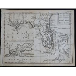
A Map of the New Governments of East & West Florida
Scarce early map of East & West Florida, shortly after the end of the French & Indian War.
Date: London, 1780
Selling price: ????
Please login to see price!
Sold in 2023
Carte de la Perse, de la Géorgie, et de la Tartarie. . .
A nice detailed map that shows Persia, Caspian Sea, Persian Gulf, etc. by the prolific French cartographer Rigobert Bonne (1727-1795), who, flourished between about 1760 ...
Date: Paris, 1780
Selling price: ????
Please login to see price!
Sold in 2023
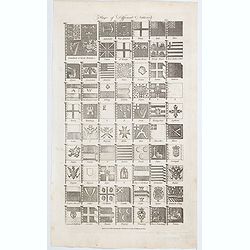
Flags of Different Nations.
A sheet of 66 various flags of different nations and companies, as they were towards the end of the eighteenth century, published in Hall's Encyclopaedia. Many individual...
Date: London, ca 1780
Selling price: ????
Please login to see price!
Sold in 2023
![[Map of Switzerland Lucerne canton.]](/uploads/cache/47454-250x250.jpg)
[Map of Switzerland Lucerne canton.]
Map sheet from a multi-sheet map of Switzerland. In the center Sempacher See and Lucerne.
Date: Germany, ca. 1780
Selling price: ????
Please login to see price!
Sold in 2025
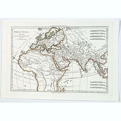
Orbis Vetus.
Rigobert Bonne's map of the ancient world, published in Paris towards the end of the eighteenth century. It shows most of Africa, the Middle East, Persia, a good deal of ...
Date: Paris, ca 1781
Selling price: ????
Please login to see price!
Sold in 2021
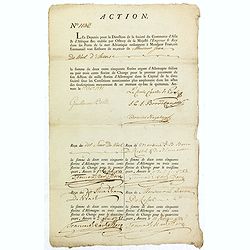
ACTION N°1130. Société du Commerce d'Asie & d'Afrique.
Share of 1 000 Florins d'Allemagne (1 000 Guilder) of the "Triester Handelsgesellschaft" (Société du Commerce d'Asie & d'Afrique) signed by duke Charles d...
Date: Antwerpen, 1 October 1781
Selling price: ????
Please login to see price!
Sold in 2019
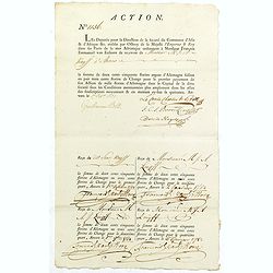
ACTION N°1156. Société du Commerce d'Asie & d'Afrique.
Share of 1 000 Florins d'Allemagne (1 000 Guilder) of the "Triester Handelsgesellschaft" (Société du Commerce d'Asie d'Afrique) signed by duke Charles de Prol...
Date: Antwerpen, 1 October 1781
Selling price: ????
Please login to see price!
Sold in 2022
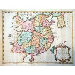
L'Impero della China.
A rare map of China, from 'Teatro della Guerra', the Italian version of Bellin's French 'Petit Atlas Maritime.'
Date: Venice, 1781
Selling price: ????
Please login to see price!
Sold in 2020
Carta dell' Isole Filippine . . .
Map of Philippines from the Italian edition of Abbè Presvost’s “Histoire Générale des Voyages”. The Histoire Géneral des Voyages was a monumental eighteenth cen...
Date: Venice, ca. 1781
Selling price: ????
Please login to see price!
Sold in 2020
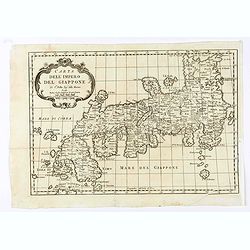
Carta dell' Impero Giappone . . .
Map of Japan from the Italian edition of Abbè Presvost’s “Histoire Générale des Voyages”. The Histoire Géneral des Voyages was a monumental eighteenth century g...
Date: Venice, ca. 1781
Selling price: ????
Please login to see price!
Sold in 2020
Il Regno die Pussia con la Prussia Polacca...
Italian copper engraved map of parts of Poland including Danzig (Gdansk), the Russian enclave of Kaliningrad, the Baltic Sea with the Lithuanian coasts. With many place n...
Date: Venice, 1781
Selling price: ????
Please login to see price!
Sold in 2020
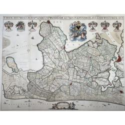
T Hoogh-Heemraetschap van de Uytwaterende Sluysen in Kennemerlant ende West-Frieslant’
A very large format wall map of the province of North Holland made and published for the district water board of Kennemerland and West Friesland, on four leaves, combined...
Date: Amsterdam, 1781
Selling price: ????
Please login to see price!
Sold in 2021
Orvis veteribus novi tabula nova. . .
Scarce map of the Ancient world, prepared by Nolin and published by L.J. Mondhare for his Atlas Général a l'usage des colleges et maisons d'education.. Louis Joseph Mon...
Date: Paris, 1781
Carte de la Barbarie de la Nigritie et de la Guinée. . .
Detailed engraved map of north west Africa including the Canary and Cape Verde Islands. The title is displayed along the top of the map. In this map De L'Isle corrects hi...
Date: Paris, 1781
Selling price: ????
Please login to see price!
Sold in 2015
![[2 maps] Carte de la partie Orientale des Philippines. / .. Occidentale ..](/uploads/cache/17587-250x250.jpg)
[2 maps] Carte de la partie Orientale des Philippines. / .. Occidentale ..
Two maps together forming a map of the Philippines, within upper left corner inset: Trombe Marine.Engraved by A.J. Gaitte and included in volume II of Le Gentil de la Gal...
Date: Paris 1781
Selling price: ????
Please login to see price!
Sold
Carte de la partie de la Virginie ou l'armée combinée de France & des Etats-Nies de l'Amérique..
Extremely rare map of the lower Chesapeake Bay emphasizes the Revolutionary War naval battle that took place off the Virginia coast prior to General Charles Cornwalllis's...
Date: Paris, after 1781
Selling price: ????
Please login to see price!
Sold
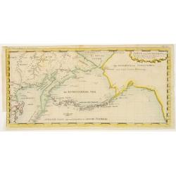
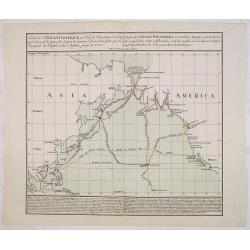
Carte der Entdekungen Zwischen Sibirien und America bis auf das Jahr 1780
Very unusual map of Alaska and Kamchatka. Alaska is shown with only coastal detail according the reports of Capt. Cook. The Aleutian Islands stretch to within sight of th...
Date: Germany c.1781
Selling price: ????
Please login to see price!
Sold
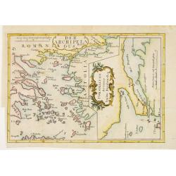
Der Archipelaagus. / Vorstellung des Canals bey den Dardanellen.
Very unusual map south eastern part of Greece and the west coast of Turkey. In right hand part a map of Strait Dardanelles.
Date: Germany c.1781
Selling price: ????
Please login to see price!
Sold
Carte de l'Océan Pacifique au Nord de l'Equateur. . .
The earliest folio-sized printed map of Cook's third voyage, on which he became the first European to discover Hawaii. On this voyage, he also explored the Northwest coas...
Date: Augsburg 1781
Selling price: ????
Please login to see price!
Sold in 2013
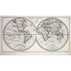
MAPPE MONDE par le...
Small but detailed map of the world in two hemispheres. Shows unfinished coastline of Australia with Tasmania and New Guinea suggested to be connected to the continent.
Date: Paris, 1781
Selling price: ????
Please login to see price!
Sold
BELGIUM.
Map of the southern part of Belgium and the northern part of France. Brussels in the north, Mons in the south, Huy in the east and Tournay/Douai in the west.
Date: Paris 1781
Selling price: ????
Please login to see price!
Sold
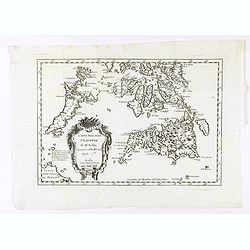
Partie Meridionale de L'Afrique.
An uncommon map of southern Africa, not listed in Tooley or Norwich. Scarce info on the interior, also has an inset of the horn of Africa top right. Large cartouche with...
Date: Paris, 1781
Selling price: ????
Please login to see price!
Sold