Browse Listings
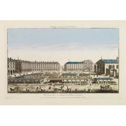
Vüe Perspective du Marché aux Fleures a Londres. (Covent Garden)
So-called optical print illustrating a perspective view of the flower market in London, now-a-days Covent Garden.In the eighteenth and nineteenth centuries there were man...
Date: Paris 1760
Selling price: ????
Please login to see price!
Sold
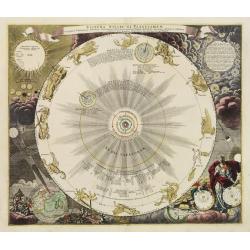
Systema solare et Planetarium..
One of J.G.Doppelmayer's celestial charts, appearing in Homann's Atlas Coelestis.It depicts the system of Copernicus with the orbits of the planets and the twelve constel...
Date: Nuremberg 1760
Selling price: ????
Please login to see price!
Sold
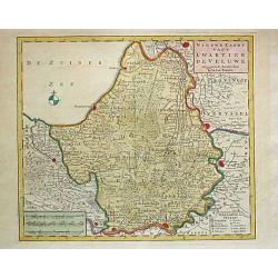
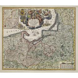
Nieuwe Kaart van't Kwartier de Veluwe. 1741.
Izaak Tirion (d. 1769) Amsterdam publisher. Published the Nieuwe en Beknopte handatlas', and ' Tegenwoordige staat van alle volkeren', a series of descriptions of countri...
Date: Amsterdam, c. 1760
Selling price: ????
Please login to see price!
Sold
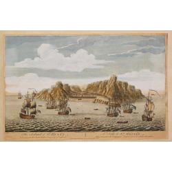
The Island of St.Helen.
A view of the island of St. Helena as seen from the sea. In the foreground English and Dutch V.O.C. ships.The island is well-known as after Napoleon Bonaparte was capture...
Date: London, c. 1760
Selling price: ????
Please login to see price!
Sold in 2008
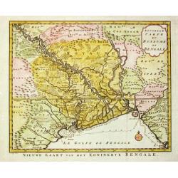
Nouvelle Carte du Royaume de Bengale.
Jaques Nicolas Bellin (1702-720) was the most important French hydrographer of the 18th century. Sea-atlas 'Hydrographique Français' (1756-65) atlas to accompany Prévos...
Date: Amsterdam, c. 1760
Selling price: ????
Please login to see price!
Sold
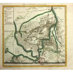
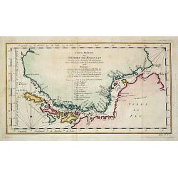
Carte du District de Tranquebar.
A map of Tranqebar and vincinity on the Coromandel coast.Jacques Nicolas Bellin (1702-720) was the most important French hydrographer of the 18th century. Sea-atlas "...
Date: Amsterdam, c. 1760
Selling price: ????
Please login to see price!
Sold in 2018
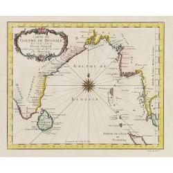
Carte du Golphe de Bengale.
Jaques Nicolas Bellin (1702-720) was the most important French hydrographer of the 18th century. Sea-atlas 'Hydrographique Français' , 1756-65, atlas to accompany Prévo...
Date: Amsterdam, c. 1760
Selling price: ????
Please login to see price!
Sold
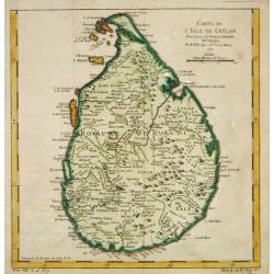
Carte de l?Isle de Ceylan, 1750.
Jaques Nicolas Bellin (1702-720) was the most important French hydrographer of the 18th century. Sea-atlas 'Hydrographique Français' (1756-65) atlas to accompany Prévos...
Date: Paris, c. 1760
Selling price: ????
Please login to see price!
Sold
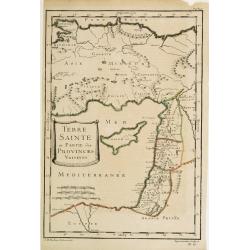
Terre Sainte et Partie des Provinces Voisines.
Uncommon map of Palestine, Turkey and an over-sized Cyprus. Engraved by Leparmantier.
Date: Paris 1760
Selling price: ????
Please login to see price!
Sold
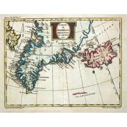
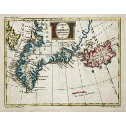
Carte de Groenland, 1770.
A map of Greenland and Iceland.
Date: Paris, c. 1760
Selling price: ????
Please login to see price!
Sold
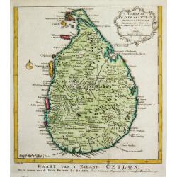
Carte de l?Isle de Ceylan, 1750.
Jaques Nicolas Bellin (1702-720) was the most important French hydrographer of the 18th century. Sea-atlas 'Hydrographique Français' , 1756-65, atlas to accompany Prévo...
Date: Amsterdam, c. 1760
Selling price: ????
Please login to see price!
Sold
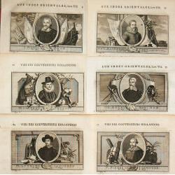
I. Pierre Both - Ier. Gouverneur General des Indes / XXVIII. Jacob Mossel XXVIII Gouverneur General des Indes
Jan van Schley is the engraver of the maps (by J.N. Bellin) and views in the Dutch edition of A.F. Prévost d' Exile's 'Histoire Géneral des Voyages.27 portraits of the ...
Date: Amsterdam, c. 1760
Selling price: ????
Please login to see price!
Sold in 2009
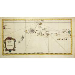
Nouvelle Carte des Isles Carolines.
Jaques Nicolas Bellin (1702-720) was the most important French hydrographer of the 18th century. Sea-atlas 'Hydrographique Français' , 1756-65, atlas to accompany Prévo...
Date: Amsterdam, c. 1760
Selling price: ????
Please login to see price!
Sold in 2008
Carte de la Mer du Sud ou Mer Pacifique..
Showing in the left southern coastline of Japan and eastern coastline of Philippines. To the right Americas West Coast from Acapulco up to Los Farollones.Showing tracks o...
Date: France c.1760
Selling price: ????
Please login to see price!
Sold
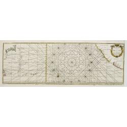
Carte Réduite des Mers du Nord. 1758.
Jaques Nicolas Bellin (1702-720) was the most important French hydrographer of the 18th century. Sea-atlas 'Hydrographique Français' , 1756-65, atlas to accompany Prévo...
Date: Paris, 1760
Selling price: ????
Please login to see price!
Sold
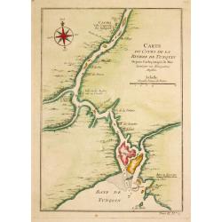
Carte du Cours de la Riviere de Tunquin.
Jaques Nicolas Bellin (1702-720) was the most important French hydrographer of the 18th century. Sea-atlas 'Hydrographique Français' , 1756-65, atlas to accompany Prévo...
Date: Paris, c. 1760
Selling price: ????
Please login to see price!
Sold in 2009
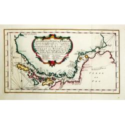
Carte réduite du Détroit de Magellan.
Jaques Nicolas Bellin (1702-720) was the most important French hydrographer of the 18th century. Sea-atlas 'Hydrographique Français' , 1756-65, atlas to accompany Prévo...
Date: Paris, c. 1760
Selling price: ????
Please login to see price!
Sold
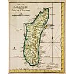
Isle de Madagascar autrement Isle de St. Laurent, 1747.
Jaques Nicolas Bellin (1702-720) was the most important French hydrographer of the 18th century. Sea-atlas 'Hydrographique Français' , 1756-65, atlas to accompany Prévo...
Date: Amsterdam, c. 1760
Selling price: ????
Please login to see price!
Sold
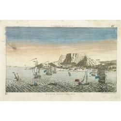
LE CAP DE BONNE ESPERANCE.
Optical view illustrating the Cape of Good Hope, a stop-over for the V.O.C., by Daumont who was a well-known publisher of optical prints, established in Paris.In the eigh...
Date: Paris 1760
Selling price: ????
Please login to see price!
Sold in 2010
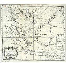
CARTE DES ISLES DE JAVA, SUMATRA, BORNEO & LES DETROITS DE LA SONDE MALACA ET BANCA GOLPHE DE SIAM ETC
Very detailed map of Indonesia by celebrated French mapmaker Nicolas Bellin. Decorated with a compass rose and an attractive title cartouche. Many Islands and harbors are...
Date: Paris, c1760
Selling price: ????
Please login to see price!
Sold
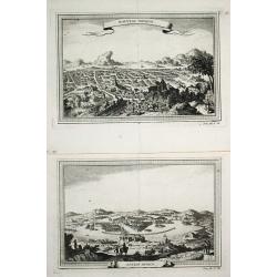
Ancien Mexico / Nouveau Mexico.
2 views of Mexico city, as in the times of the conquestedores and as in the 18th century.
Date: Paris, c. 1760
Selling price: ????
Please login to see price!
Sold
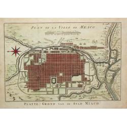
Plan de la Ville de Meaco.
Jaques Nicolas Bellin (1702-720) was the most important French hydrographer of the 18th century. Sea-atlas 'Hydrographique Français' , 1756-65, atlas to accompany Prévo...
Date: Amsterdam, c. 1760
Selling price: ????
Please login to see price!
Sold in 2016
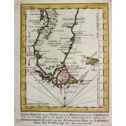
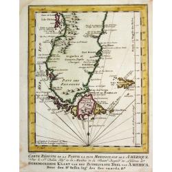
Carte Réduite de la Partie la plus Meridionale de l'Amerique.
Jaques Nicolas Bellin (1702-720) was the most important French hydrographer of the 18th century. Sea-atlas 'Hydrographique Français' , 1756-65, atlas to accompany Prévo...
Date: Amsterdam, c. 1760
Selling price: ????
Please login to see price!
Sold
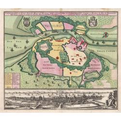
![Plan de Prag. [Manuscript plan of Prague - Praha]](/uploads/cache/24911-250x250.jpg)
Plan de Prag. [Manuscript plan of Prague - Praha]
Very nice manuscript plan of Prague and the castle. Not dated or signed. In upper left a numbered key 1-36 referring to the ramparts of the town and a scale (of 1:700 aul...
Date: [France] ca. 1760
Selling price: ????
Please login to see price!
Sold
Carte de Groenland, 1770.
A map of Greenland and Iceland.
Date: Paris, c. 1760
Selling price: ????
Please login to see price!
Sold in 2018
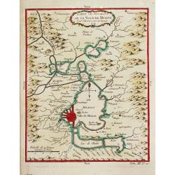
Carte des Environs de la Ville de Mexico, 1754.
Jaques Nicolas Bellin (1702-720) was the most important French hydrographer of the 18th century. Sea-atlas 'Hydrographique Français' , 1756-65, atlas to accompany Prévo...
Date: Paris, c, 1760
Selling price: ????
Please login to see price!
Sold
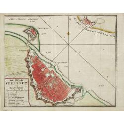
De Stad Vera Cruz in Nieuw Spanje.
Izaak Tirion (d. 1769) Amsterdam publisher. His "Nieuwe en beknopte handatlas" saw 6 editions between before 1740 and after 1784. Also "Tegenwoordige staat...
Date: Amsterdam, c. 1760
Selling price: ????
Please login to see price!
Sold in 2014
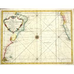
Carte de l' Ocean Meridional, 1746.
Jaques Nicolas Bellin (1702-720) was the most important French hydrographer of the 18th century. Sea-atlas 'Hydrographique Français' , 1756-65, atlas to accompany Prévo...
Date: Amsterdam, c. 1760
Selling price: ????
Please login to see price!
Sold
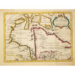
Carte de la Baye de Hudson.
Jaques Nicolas Bellin (1702-720) was the most important French hydrographer of the 18th century. Sea-atlas 'Hydrographique Français' , 1756-65, atlas to accompany Prévo...
Date: Paris, c. 1760
Selling price: ????
Please login to see price!
Sold in 2019
Carte Réduite de la Partie la plus Meridionale de l'Amerique.
Jaques Nicolas Bellin (1702-720) was the most important French hydrographer of the 18th century. Sea-atlas 'Hydrographique Français' , 1756-65, atlas to accompany Prévo...
Date: Amsterdam, c. 1760
Selling price: ????
Please login to see price!
Sold in 2008
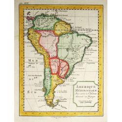
Amerique Meridionale.
Jaques Nicolas Bellin (1702-720) was the most important French hydrographer of the 18th century. Sea-atlas 'Hydrographique Français' , 1756-65, atlas to accompany Prévo...
Date: Paris, c. 1760
Selling price: ????
Please login to see price!
Sold in 2008
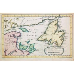
Carte du Golphe de St. Laurent et Pays Voisins.
Jaques Nicolas Bellin (1702-720) was the most important French hydrographer of the 18th century. Sea-atlas 'Hydrographique Français' , 1756-65, atlas to accompany Prévo...
Date: Paris, c. 1760
Selling price: ????
Please login to see price!
Sold in 2008
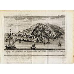
Tanger, Citta Marittima del Regno di Fez sulla Costa di Barbaria, nell'Africa.
Curious and decorative town-view of Tanger in Morocco. Several sailings ships are shown, the city with fortified walls and towers and many buildings. Unidentified and rar...
Date: ca. 1760
Selling price: ????
Please login to see price!
Sold in 2014
Borussiae Regnum..
With decorative title cartouche in upper part and an inset (155x115mm.) of Neufchatel.Expertly repaired map, with great presentation value.
Date: Augsburg, 1760
Selling price: ????
Please login to see price!
Sold in 2011
Carte réduite du Détroit de Magellan
Jaques Nicolas Bellin (1702-720) was the most important French hydrographer of the 18th century. Sea-atlas ''Hydrographique Français'' , 1756-65, atlas to accompany Pré...
Date: Amsterdam, c. 1760
Selling price: ????
Please login to see price!
Sold in 2008
Carte de la Coste Occidentale d' Afrique depuis le XIe. Degré jusqu'au Cap de Bonne Esperance.
A map of the west coast of South Africa with the Cape of Good Hope. With a nice title-cartouche. From a Dutch edition of Prevost's "Voyages".Jacques Nicolas Bel...
Date: Amsterdam, c. 1760
Selling price: ????
Please login to see price!
Sold in 2020

Portrait of Johan Maurits van Nassau, governor of the Dutch colony in Brazil in the early 17th century.
Published by Isaac Tirion, Amsterdam ca. 1760, as part of a series of prints of historical figures.
Date: Amsterdam, c.1760
Selling price: ????
Please login to see price!
Sold in 2008
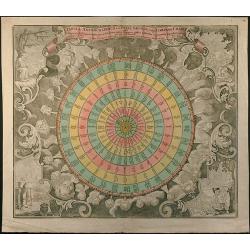
Tabula Anemographica seu Pyxis Nautica, vulgo Compass Charte
Wind map in stile of a wind rose. Original old coloring by the publisher.
Date: Augsburg, 1760
Selling price: ????
Please login to see price!
Sold in 2015
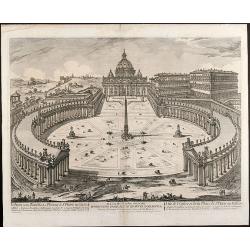
Veduta della Basilica e Piazza di S. Pietro in Vaticano
Etching of St. Peter's Basilica and Plazza in Vatican / Rome by Jean Barbault. It shows a authentic view of the Basilica in the middle of 18th century.
Date: Rome, 1760
Selling price: ????
Please login to see price!
Sold in 2009
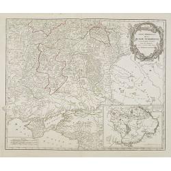
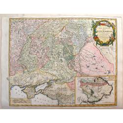
Partie Méridionale de la Russie Européenne. . .
Detailed map of Ukraine and Crimea. In the lower right corner inset map of Cosaques. A later edition, in which part of the address in the title cartouche was removed, and...
Date: Paris, ca 1760
Selling price: ????
Please login to see price!
Sold in 2008
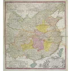
Regni Sinae vel Sinae propriae..
General map of China, including the islands of Taiwan and Hainan. The map is based on the work of du Halde. An appealing title cartouche bottom right with allegorical ima...
Date: Nuremberg, 1760
Selling price: ????
Please login to see price!
Sold in 2011
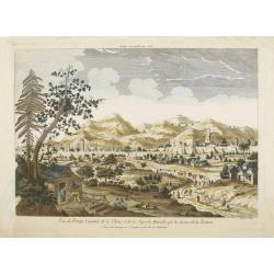
Vue de Peking Capitale de la Chine, et de la Superbe Muraille qui la Separe de la Tartarie.
So-called optical print showing panoramic view of Beijing with the Great Wall in the background.In the eighteenth and nineteenth centuries there were many popular special...
Date: Paris, 1760
Selling price: ????
Please login to see price!
Sold
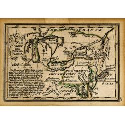
NEW YORK AND PENSILVANIA
Charming little map of the Great Lakes, showing also Maryland, New York, and Pennsylvania. From the Atlas Minimus Illustratus. Includes Philadelphia, Ft. du Quesne, Kuski...
Date: London, c.1760
Selling price: ????
Please login to see price!
Sold in 2009
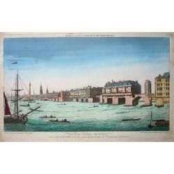
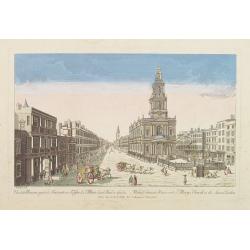
Premiere nouvelle vue d\'optique représentant une partie de la ville de Londres prise du faubourg de Saint Octave sur la Tamise
So-called optical print showing a fine view of a bridge over the river Thames in London, with houses built on it. Several ships on the river, large and small, complete th...
Date: Paris, ca. 1760
Selling price: ????
Please login to see price!
Sold in 2009

Portrait of Johan Maurits van Nassau, governor of the Dutch colony in Brazil in the early 17th century.
Published by Isaac Tirion, Amsterdam ca. 1760, as part of a series of prints of historical figures.
Date: Amsterdam, ca. 1760
Selling price: ????
Please login to see price!
Sold in 2009
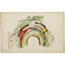
Anamorphose
Copper engraving in original colors, pasted on card board, as issued. This rare (catoptric) anamorphosis, is to be viewed with a cylindrical mirror, placed on the print. ...
Date: Paris, 1760
Selling price: ????
Please login to see price!
Sold

Vue du Palais Royal de Hampton Court a 15 Mille de Londres.
So called optical print of the Hampton Court Royal Palace Royal Gardens near London. Published by the brothers Chéreau, active in Paris at rue St. Jacques au dessus de l...
Date: Paris, 1760
Selling price: ????
Please login to see price!
Sold in 2019
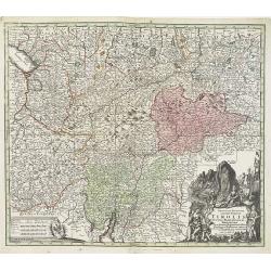
Principali Dignitate Gaudens Comitat. Tirolis Episcopat. Tridentinum et Brixiensem ut et Comitat. Brigantinum Feldkirch Sonneberg et Pludentinum contingens quo ad omnes Urbes. . .
The mountainous borders of Italy, Switzerland & Austria, with an allegorical title cartouche lower right. Centered on the course of the Inn River and including Lake G...
Date: Nuremberg, ca. 1760
Selling price: ????
Please login to see price!
Sold in 2020
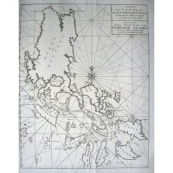
Carte du Canal des Isles Philippines par lequel passe le Galion de Manille et les Iles voisines
Large and detailed chart tracking the route of the Galleons from Manila. With the title in French and Dutch. Very detailed showing many bays, islands, sand banks, and de...
Date: Amsterdam, ca. 1760
Selling price: ????
Please login to see price!
Sold in 2009
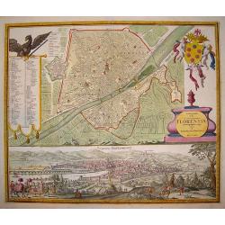
Ichonographia urbis...Florentina
A beautifully engraved, decorative plan of Florence with exceptional detail. A large coat-of-arms graces the top right hand corner of the plate. In the left section is a ...
Date: Nuremberg, (dated 1731) 1760
Selling price: ????
Please login to see price!
Sold in 2009
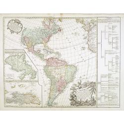
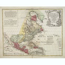
L'Amérique septentrionale et Meridionale divisée en ses principales parties . . .
Unrecorded state of this fine map of the western hemisphere with inset maps of Martinique and Santa Domingo. To the right a text column showing the regional division of t...
Date: Paris, 1760
Selling price: ????
Please login to see price!
Sold in 2015
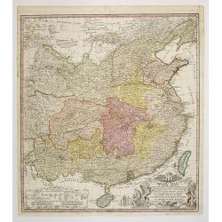
Regni Sinae vel Sinae propriae..
General map of China, including the islands of Taiwan and Hainan. The map is based on the work of du Halde. An appealing title cartouche bottom right with allegorical ima...
Date: Nuremberg, 1760
Selling price: ????
Please login to see price!
Sold in 2011
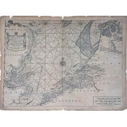
A Correct Chart of the Sea Coasts of England, Flanders and Holland showing the Sands, Shoals, Rocks and Dangers, The Bays and Harbours, Roads, Buoys, Beasons and Seamarks on the said Coasts.
A fine nautical chart of the coasts of Belgium, Holland, and Southern England by Mount and Page. The Mount and Page publishers firm of London was founded in 1701 by Richa...
Date: London, c.1760
Selling price: ????
Please login to see price!
Sold in 2010
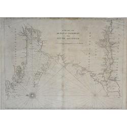
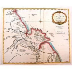
A Chart of the Bay of Galloway and River Shannon. . .
A fine nautical chart of the coastline along the Galway Bay of western Ireland by Mount and Page. The Mount and Page publishers firm of London was founded in 1701 by Rich...
Date: London, c.1760
Selling price: ????
Please login to see price!
Sold in 2010
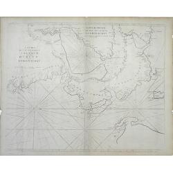
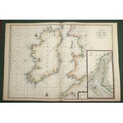
A Chart of the Seacoasts of Ireland from Dublin to London-Derry. . .
A fine nautical chart of the coastline along the northeast coast of Ireland, showing city of Dublin, by Mount and Page. The Mount and Page publishers firm of London was f...
Date: London, c.1760
Selling price: ????
Please login to see price!
Sold in 2010
Cataloniae Principatus et Ruscinonis ae Cerretaniae Comitatuum exactissima Delineatio, Cura et Studio. . .
Beautifully colored map of the Catalonia region of northeastern Spain by Tobias Conrad Lotter. The cities of Barcelona, Tortosa, Tarragona are depicted along the Mediterr...
Date: Augsburg, c.1760
Selling price: ????
Please login to see price!
Sold in 2010
Novissima Regnorum Portugalliae et Algarbiae descriptio.
Map of Portugal. Fine title and scale cartouche. With privilege of the State of Holland. The edition published by Covens and Mortier. Now with their address added.The Ams...
Date: Amsterdam, ca. 1760
Selling price: ????
Please login to see price!
Sold in 2010

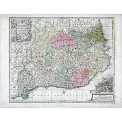
Circuli Austriaci pars Septentrionalis in qua Archiducatus. . .
Decorative and detailed map of Austria, here in a second state with the address of Jean Covens and Cornelis Mortier.The Amsterdam publishing firm of Covens and Mortier (1...
Date: Amsterdam, c. 1760
Selling price: ????
Please login to see price!
Sold in 2011
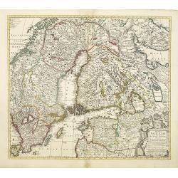
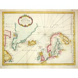
Regni Sueciae.
Attractive and detailed map of Scandinavia, including part of Russia, here in a second state with the address of Jean Covens and Cornelis Mortier.The Amsterdam publishing...
Date: Amsterdam, 1760
Selling price: ????
Please login to see price!
Sold in 2011
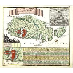
Melite vulgo Malta cum vicinis Goza..
Highly decorative map of Malta and the island of Gozo with figurative cartouche, title banner, inset view of a Maltese ship seen from the stern, inset plan of the city an...
Date: Augsbourg, 1760
Selling price: ????
Please login to see price!
Sold in 2010
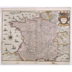
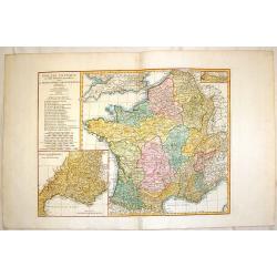
La France. Dressée suivant les nouvelles observation de Mrs De l'Academie Royale des Sciences Par Charles Inselin geografe et graveur.
A large and detailed map of France, decorated with a large title cartouche, and two others around engraved text descriptions of France and its provinces. Originally issue...
Date: Paris, 1760
Selling price: ????
Please login to see price!
Sold in 2011
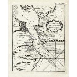
Plan du port de Lisbonne.
Highly detailed chart of the bay of Lisbon by the famous French geographer Nicolas Bellin. Shows the area with numerous forts, towns, and important landmarks along the co...
Date: Paris, ca. 1760
Selling price: ????
Please login to see price!
Sold in 2012
Vue de la Maison royale de Somerset avec l'Eglise de Ste. Marie dans le Strand a Londres. . .
So-called optical print illustrating the Somerset House with St. Mary's Church in the Strand London as indicated in the title. In the eighteenth and nineteenth centuries ...
Date: Paris, 1760
Selling price: ????
Please login to see price!
Sold in 2019
Carte Generale de Costes D'Irlande, et des Costes Occidentales D'Angleterre avec une Partie de celles D'Ecosse.
Very large engraved sea chart, with inset view of the River Dee at Chester. The chart showing the whole of Ireland and the Westcoast of England from Cornwall to Cuningham...
Date: Paris, 1760
Selling price: ????
Please login to see price!
Sold in 2011
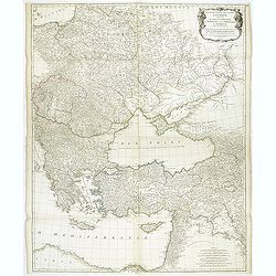
Troisieme partie de la carte d'Europe, contenant le midi de la Russie, la Pologne, et la Hongrie, la Turquie y compris celle d'Asie presqu'entiere. . .
Wall map sized map of Russia, Crimea, Turkey, Cyprus and Holey Land. Centered on the Black Sea. Prepared by Jean Baptiste Bourguignon d'Anville (1697-1782). Ornamental ca...
Date: Paris, 1760
Selling price: ????
Please login to see price!
Sold in 2011
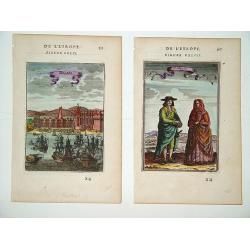
Belem (left) and Portugais (right)
A pair of well defined and decorative 18th century prints. One depicts Mosteiro dos Jeronimos in the Belem section of Lisbon and the other an affluent couple in typical l...
Date: Paris, ca. 1760
Selling price: ????
Please login to see price!
Sold in 2011
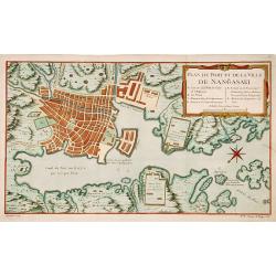
Plan du port et de la ville de Nangasaki.
This plan originates from Charlevoix's work Histoire et description Générele du Japon . His first in 1715 published work was the Histoire de l'etablissement du christia...
Date: Paris, 1760
Selling price: ????
Please login to see price!
Sold in 2023
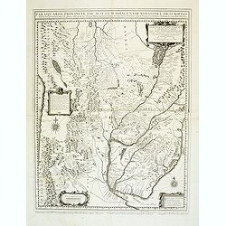
Paraquariae Provinciae Soc. Jesu cum adiacentib. novissima descriptio. . .
Uncommon large map of the Paraguay provinces ruled by the Jesuits from Atlantic to Pacific ocean, including most of Peru, Bolivia, Brazil, Uruguay, Argentina and Chile, w...
Date: Venice, 1760
Selling price: ????
Please login to see price!
Sold in 2012
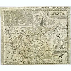
Accurate Geographische delineation. . . Des Ammtes grossen Hayn. . .
Very detailed map prepared by Adam Frederic Zürner (1680-1742). Surrounded with legends and decorated in the lower right corner with a plan of a royal campement. The tow...
Date: Amsterdam, 1760
Selling price: ????
Please login to see price!
Sold in 2016
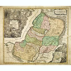
Palaestina accurata descriptio geographica. . .
Map of the Holy Land, with two very large cartouches. Lower left with inset of travels of the Israelites.
Date: Nuremberg, 1760
Selling price: ????
Please login to see price!
Sold in 2012
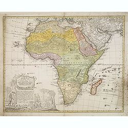
Africa Secundum legitimas Projectionis Stereographicae regul..
An ornate title consisting of a panel surrounded by elephant's tusks rests on a piece of masonry containing a long description. With an interview between Europeans and Af...
Date: Nuremberg, ca. 1760
Selling price: ????
Please login to see price!
Sold in 2012
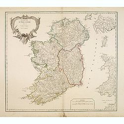
Royaume d'Irlande divisé en ses quatre Provinces.
Fine map of Ireland, engraved by the master Delahaye. Fine title cartouche. With ereased date.
Date: Paris, ca.1760
Selling price: ????
Please login to see price!
Sold in 2012
The Island & Colony of Cayenne Subject to the French, on the Continent of South America.
Scarce map of French Guiana was created by Thomas Jefferys (1695-1771) in 1760. He was geographer to his Royal Highness, the Price of Wales and was one of the most prolif...
Date: London, 1760
Selling price: ????
Please login to see price!
Sold in 2014
Tartaria.
Attractive, simple map of Tartary and China.
Date: c. 1760
Selling price: ????
Please login to see price!
Sold in 2013
Partie Meridonale de la Russie Europeeennee
Important map of the southern part of Russia and the Ukraine. It has an inset of "Development de la Nouvelle Servie". Decorated with Rococo-style title cartouch...
Date: Paris, ca 1760
Selling price: ????
Please login to see price!
Sold in 2014
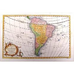
An Accurate Map of South America Drawn from the Sieur Robert.
Detailed map of South America by George Rollos. From Vaugondy's map. Decorated with a fancy Rococo cartouche.
Date: Paris, c1760
Selling price: ????
Please login to see price!
Sold in 2013
America Septentrionalis concinnata . . .
After the foundation map by de L'Isle published in 1700: which was the first map to reconnect California to the mainland and shows good detail for the Great Lakes and Hud...
Date: Augsburg, 1760
Selling price: ????
Please login to see price!
Sold
Coppenhagen die Konigl ...
A colored birds-eye view of Copenhagen. At bottom an uncolored panoramic view (100x570mm) with a legend, referring to all important buildings. A most decorative item, pub...
Date: Augsburg, 1760
Selling price: ????
Please login to see price!
Sold in 2013
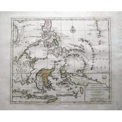
Nieuwe Kaart van de Filippynsche, Ladrones, Moluccos of Specery Filanden, als Mede Celebes etc.
Very detailed map of the Philippine islands and eastern Indonesia. With hundreds of tiny islands, including the famous Spice Islands here called Specery Eilenden. Further...
Date: Amsterdam, c1760
Selling price: ????
Please login to see price!
Sold in 2013
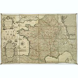
Gallia Antiqua ex Aevi Romani Monumentis Eruta.
A fine copper engraved map of France and Belgium in ancient times. The title section includes a list of regions by Roman numeral to make them easier to find. The detailed...
Date: Paris, 1760
Selling price: ????
Please login to see price!
Sold in 2015