Browse Listings
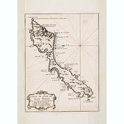
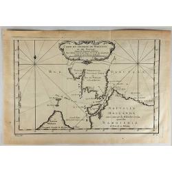
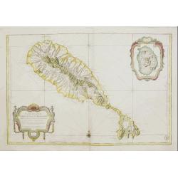
Carte de L'Isle de Jean Mayen. . .
Charming map of Jan Mayen Island, a volcanic island in the Arctic Ocean and part of the Kingdom of Norway. Several sounding shown.From Prevost's l'Histoire générale des...
Date: Paris, 1758
Selling price: ????
Please login to see price!
Sold in 2016
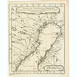
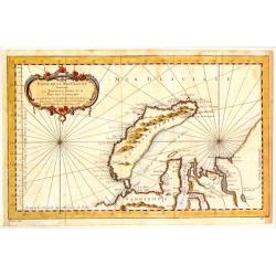
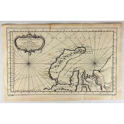
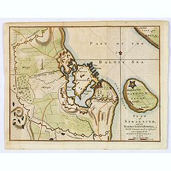
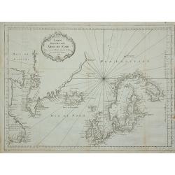
Suite du Golphe de Bothnie. . .
Charming map of the northernmost portion of the Golf of Bothnia, which separates Sweden and Finland. Several sounding shown.From Prevost's l'Histoire générale des voyag...
Date: Paris, 1758
Selling price: ????
Please login to see price!
Sold in 2018
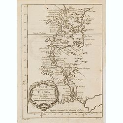
Carte des environs de Tornea. . .
Charming map of the area around Tornio in Finland. Several sounding shown.From Prevost's l'Histoire générale des voyages , the map prepared by J.N. Bellin. Jacques Nico...
Date: Paris, 1758
Selling price: ????
Please login to see price!
Sold in 2017
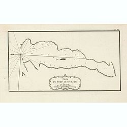
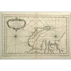
Plan du port d'Ingeson en Norvege.
Charming map of the Porsangerfjorden in northern Norway. The 123-kilometre long fjord is Norway's fourth longest fjord. It is located in the municipalities of Nordkapp an...
Date: Paris, 1758
Selling price: ????
Please login to see price!
Sold in 2021
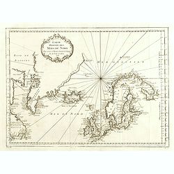
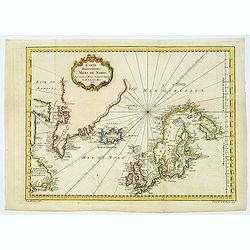
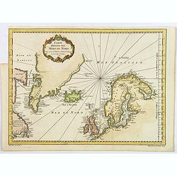
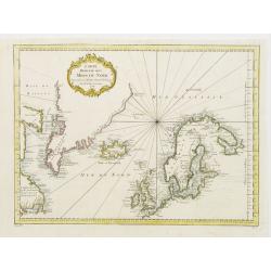
Carte Réduite des Mers du Nord Pour servir a l'Histoire Generale des Voyages.
Detailed sea chart of the coasts of Scandinavia, the British Isles, Iceland (with volcano Hekla), Greenland and contiguous parts of Canada.Prepared by Nicholas Bellin for...
Date: 1758
Selling price: ????
Please login to see price!
Sold in 2014
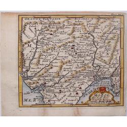
Mogol.
This fine little map shows Northern India and Pakistan including Kabul, Delhi & Gulf of Bengal.
Date: Paris, 1758
Selling price: ????
Please login to see price!
Sold in 2017
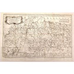
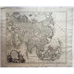
Carte de la Siberie et des Pays Voisins.
An interesting detailed map of North-Western Siberia, extending from the White Sea and the Caspian Sea in the west to Irkuckoi Province.Prepared by Jacques Nicolas Bellin...
Date: Paris, 1758
Selling price: ????
Please login to see price!
Sold in 2015
Carte du Detroit de Waegats ou de Nassau.
Interesting map of Northern Russia featuring the south (warm) side of the island, Nouvelle Zemble, one of the coldest places on earth. By Nicholas Bellin in France in 175...
Date: Paris, 1758
Selling price: ????
Please login to see price!
Sold in 2015
Partie de la Mer Glaciale Contenant la Nouvelle Zemle.
Detailed map of Nova Zembla and part of the Northeast passage in Northwest Russia. Published in "L'HISTOIRE GENERALE DES VOYAGES" by Nicholas Bellin.
Date: Paris, 1758
Selling price: ????
Please login to see price!
Sold in 2017
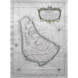
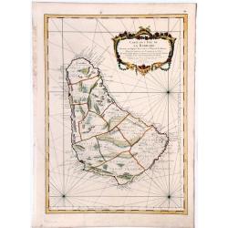
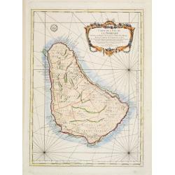
Carte de l'Isle de la Barbade dressee au Depost des Cartes et Plans de la Marine...
Bellin's famous large scale map of Barbados - one of the best antique maps of the island, with many details such as parishes, villages, churches, streets, anchorages, sho...
Date: Paris, 1758
Selling price: ????
Please login to see price!
Sold in 2016
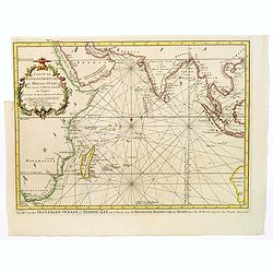
Kaart van den Oostersen Oceaan, of Indiese Zee......
Intriguing map of the Indian Ocean, with partial outlines of Australia, South East Asia, India, Arabia and Eastern Africa and Madagascar. With title in French (and Dutch ...
Date: Amsterdam, ca 1758
Selling price: ????
Please login to see price!
Sold in 2016
El Asia con toda la Extension de susReinos y Provincias Segun las ultimas y nuevas Observationes
A rare Spanish map of Asia. Translation of the title is - "Asia to the full extent of their Kingdoms and Provinces According to the latest and new Observations."...
Date: Madrid, ca. 1758
Selling price: ????
Please login to see price!
Sold in 2016
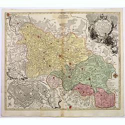
Nova Mappa Geographica Totius Ducatus Silesiae. . .
A striking map of Silesia by Lotter, published in the mid eighteenth century.The map covers central Europe in general, and parts of Poland in particular. Most of Silesia ...
Date: Augsberg, 1758
Selling price: ????
Please login to see price!
Sold in 2017
![Karte von dem laufe des Flusses St. Laurenz von seiner Mündung an bis über Quebec. . .1757. [together with] Fernerer Lauf des Flusses St. Laurentz. . .](/uploads/cache/39140-250x250.jpg)
Karte von dem laufe des Flusses St. Laurenz von seiner Mündung an bis über Quebec. . .1757. [together with] Fernerer Lauf des Flusses St. Laurentz. . .
Two maps of the entrance of the St. Laurence river up beyond Quebec. With a second map from Quebec to Lake Ontario.From a German edition of the ' Histoire. des Voyages'. ...
Date: Augsburg, 1758
Selling price: ????
Please login to see price!
Sold in 2018
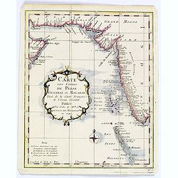
Carte des Costes de Perse Gusarat et Malabar. . .
Detailed copper engraved map of the Persian Gulf and western India, from Perse (Persia), and Grand Mogol in the north, down to the southern tip of India, including the Ma...
Date: Paris, ca. 1758
Selling price: ????
Please login to see price!
Sold in 2018
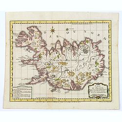
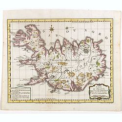
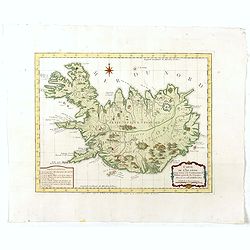
Carte de l'Islande pour servir á la continuation de l'histoire générale des voyages. Dressée sur celle de M. Horrebows.
A good engraved map of the island of Iceland, prepared by Bellin after M. Horrebows, with rococo title cartouche in lower right, explanation table bottom left. From l'His...
Date: Paris, 1758
Selling price: ????
Please login to see price!
Sold in 2017
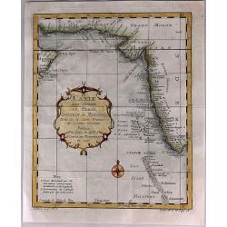
Carte des Costes de Perse, Gusarat et Malabar.
A detailed copper engraved map of the Persian Gulf and western India, from Perse (Persia), and Grand Mogol in the north, down to the southern tip of India, including the ...
Date: Paris, 1758
Selling price: ????
Please login to see price!
Sold in 2017
Carte du Detroit de Waeigats ou de Nassau.
Detailed regional map of the Strait of Waeigats in the Arctic Sea. Includes a decorative title cartouche. One of the maps produced by Bellin for Prevost d'Exiles' influen...
Date: Paris, 1758
Selling price: ????
Please login to see price!
Sold in 2017
Partie de la Mer Glaciale Contenant la Nouvelle Zemble et le Pais des Samoiedes.
An attractive copper engraved map of Nova Zembla, a frigid island north of Russia. It has a decorative rococo title cartouche. Jacques Nicolas Bellin (1703–1772) was a ...
Date: Paris, 1758
Selling price: ????
Please login to see price!
Sold in 2018
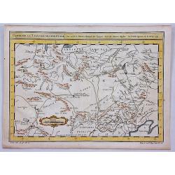
Carte de la Tartarie Occidentale Pour Servir a L'Histoire Generale des Voyages Tiree des Auteurs Anglois.
A map of Western Tartary, covering present-day Northern China and Mongolia. The site of Genghis Khan's ancient Mongol capital of Karakum (Karakorum) is centrally marked o...
Date: Paris, 1758
Selling price: ????
Please login to see price!
Sold in 2019
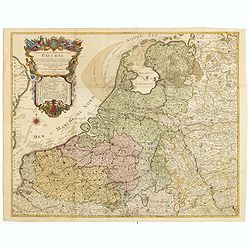
Carte des XVII provinces des Pays-Bas . . .
Fine two-sheet wall-map size map of present-day The Netherlands and Belgium with a decorative armorial cartouche and small scale of miles.Alexis-Hubert Jaillot (1632-1712...
Date: Paris, 1758
Selling price: ????
Please login to see price!
Sold in 2018
Carte de l'Islande pour servir á la continuation de l'histoire générale des voyages. Dressée sur celle de M. Horrebows.
A good engraved map of the island of Iceland, prepared by Bellin after M. Horrebows, with rococo title cartouche in lower right, explanation table bottom left. From l'His...
Date: Paris, 1758
Selling price: ????
Please login to see price!
Sold in 2019
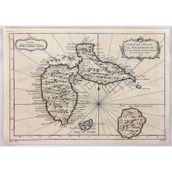
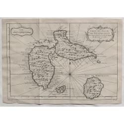
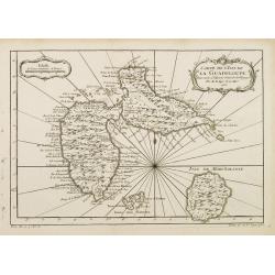
Carte de l'Isle de la Guadeloupe.
Jacques Bellin's elegant map of Guadeloupe, and the adjacent islands of Les Sainte and Marie Galante. With excellent topographical details, many place names, radiating rh...
Date: Paris, 1758
Selling price: ????
Please login to see price!
Sold in 2020
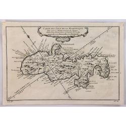
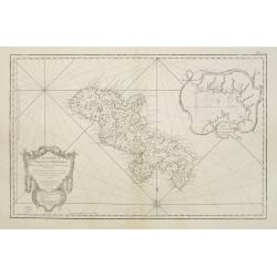
Carte de l'Isle de la Martinique.
A well engraved map of Martinique. The geographical features are typical, with somewhat exaggerated bays and inlets. From the l'Histoire Générale des Voyages. It featur...
Date: Paris, 1758
Selling price: ????
Please login to see price!
Sold in 2018
Carte Réduite des Mers du Nord Pour servir a l'Histoire Generale des Voyages.
A lovely general map of the Arctic Regions, including parts of Western, Canada, Greenland, Iceland, Scandinavia, the British Isles, and portions of western Russian shores...
Date: Paris, 1758
Selling price: ????
Please login to see price!
Sold in 2018
Carte Reduite des Mers du Nord.
A nice detailed sea chart of the coasts of Scandinavia, the British Isles, Iceland, Greenland and contiguous parts of Canada. Includes a decorative title cartouche. One o...
Date: Paris, 1758
Selling price: ????
Please login to see price!
Sold in 2021
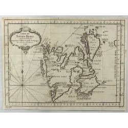
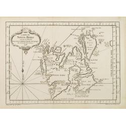
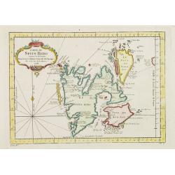
Carte de Spits-Berg Suivant les Hollandois.
A detailed map of Spitsbergen with the adjacent islands; the largest permanently populated island of the Svalbard Archipeligo in Norway. It features a French style decor...
Date: Paris, 1758
Selling price: ????
Please login to see price!
Sold in 2018
Carte de l'Islande pour servir á la continuation de l'histoire générale des voyages. Dressée sur celle de M. Horrebows.
A good engraved map of the island of Iceland, prepared by Bellin after M. Horrebows, with rococo title cartouche in lower right, explanation table bottom left. From L'His...
Date: Paris, 1758
Selling price: ????
Please login to see price!
Sold in 2021
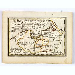
Prussia.
An attractive 18th century miniature map of Prussia which was drawn and engraved by John Gibson for the pocket atlas, Atlas Minimus Illustratus: Containing Fifty-Two Pock...
Date: London, 1758
Selling price: ????
Please login to see price!
Sold in 2021
Plan of Stralsund, with the Trenches Lines & Batteries. . .
Stralsund is a Hanseatic town in the Pomeranian part of Mecklenburg-Vorpommern, in Germany. It is located at the Southern coast of the Strelasund, a sound of the Baltic S...
Date: London, 1758
Selling price: ????
Please login to see price!
Sold in 2021
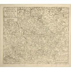
Nuova Carta del Regno di Boemia, Ducato di Slesia, Marchesato di Moravia e Lusazia.
Detailed map of the Southern part of Poland, Moravia and Bohemia, pubished in Italian edition of Thomas Salmon's "Modern History", published in Naples by Franc...
Date: Venice, 1758
Selling price: ????
Please login to see price!
Sold in 2021
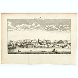
Vue de Goa.
Fine plan of Goa. Goa was made as capital of the Portuguese Vice-Kingdom in Asia, and the other Portuguese possessions in India.
Date: Paris, 1758
Selling price: ????
Please login to see price!
Sold in 2022
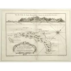
Vue de L'isle de Juan Fernandes. . .
A striking map of Juan Fernandez Island also known as Mas a Tierra. It is west of San Antonio, Chile in the South Pacific. It is thought to have inspired Robinson Crusoe....
Date: Paris, 1758
Selling price: ????
Please login to see price!
Sold in 2020
Partie de la Mer Glaciale, Contenant La Nouvelle Zemble et le Pais des Samoiedes.
A detailed map of Nova Zembla and part of the Northeast Passage at the top of Russia. From Prevost’s L’Histoire General des Voyages. It features a rococo cartouche.Ja...
Date: Paris, 1758
Selling price: ????
Please login to see price!
Sold in 2019
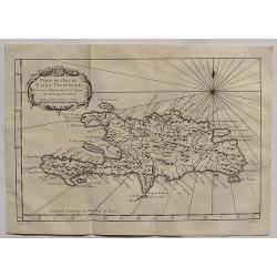
Carte de L'Isle de Saint Domingue.
A fine 1758 Bellin map of the Dominican Republic and Haiti. Taken from a later edition of Abbe A.F. Prevost d'Exiles's "Histoire generale des voyages". It featu...
Date: Paris, 1758
Selling price: ????
Please login to see price!
Sold in 2020
Carte de L'Isle de la Guadaloupe.
A fine 1758 Bellin map of Guadeloupe. Taken from a later edition of Abbe A.F. Prevost d'Exiles's "Histoire generale des voyages". It features a decorative flora...
Date: Paris, 1758
Selling price: ????
Please login to see price!
Sold in 2020
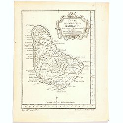
Carte de l'Isle de la Barbade. . .
One of the finest early maps or charts of Barbados. The island is divided into parishes and details cities & towns, mountains, forests, anchorages, shouls, and rocks....
Date: Paris, 1758
Selling price: ????
Please login to see price!
Sold in 2020
Carte de l'Isle de la Barbade.
A large engraved nautical chart,also showing the division of the Parishes, towns and fortifications. An exceptional onboard document of this rare and fabulous maritime at...
Date: Paris, 1758
Selling price: ????
Please login to see price!
Sold in 2020
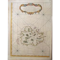
ANTIGUA, - Carte reduite de l'isle d'Antigue ; dressée au Dépost des cartes, plans et journaux de la marine : pour le service des vaisseaux du roy. . .
A very rare and large nautical map of the island of Antigua, by Bellin, at Dépost des cartes, plans et journaux de la marine. Relief shown pictorially. Depths by soundin...
Date: Paris, 1758
Selling price: ????
Please login to see price!
Sold in 2022
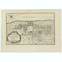
Grundriss von der Stadt Buenos-Ayres.
The early layout of the town of Buenos Aires is shown in block formation, with a few of the important buildings named, these include: the Governor's Residence, the City H...
Date: Leipzig, 1758
Selling price: ????
Please login to see price!
Sold in 2023
Carte réduite de l'isle d'Antigue
Large and detailed chart of Antigua. One of the best 18th Century maps of the island. Shows villages, windmills, hills, streets, Parishes, bays, anchorages, depth soundin...
Date: Paris, 1758
Selling price: ????
Please login to see price!
Sold in 2022

La Brebis
Decorative copper engraving from "Histoire naturelle" by Georges-Louis Leclerc, comte de BUFFON, this great naturalist (1707-88) spent the greater part of his l...
Date: Paris 1758
Selling price: ????
Please login to see price!
Sold
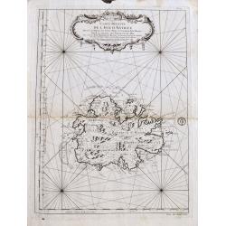
Carte Réduite De L'Isle De Saint Christophe..
A well engraved and highly detailed large-scale map of St. Kitts, with highly detailed topography , many place names, and a beautiful title cartouche. At the upper right ...
Date: Paris, 1758
Selling price: ????
Please login to see price!
Sold in 2018
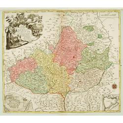
MAPPA GEOGRAPHICA SPECIALIS MARCHIONATUS MORAVIAE IN SEX CIRCULOS DIVISAE?
Map depicting the South/East part of Czech republic, showing Brno and Olomouc and two insets of these cities lower corners.
Date: Augsburg, 1758
Selling price: ????
Please login to see price!
Sold
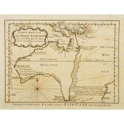
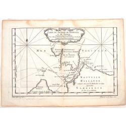
Carte réduite des Terres Australes..
A nice and decorative map of Australia. Van Diemenland still joined to the main island, prepared by J.N.Bellin. Title cartouche with French text. Underneath the map a tit...
Date: Amsterdam 1758
Selling price: ????
Please login to see price!
Sold
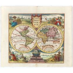
Typus Orbis Terrarum.
Decorative world map showing California as an island after the second Sanson model. The figures in each corner symbolise the four continents.
Date: Nuremberg, 1758
Selling price: ????
Please login to see price!
Sold in 2023
Carte de L'Isle de la Barbade Dressee au depost des cartes et plans de la marine..
This large scale coastal chart of Barbados, with hand-coloring, large decorative cartouche. Bellin (1703-1772) began working for the newly established Dépôt des Cartes ...
Date: Paris 1758
Selling price: ????
Please login to see price!
Sold
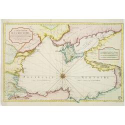
Carte réduite de la Mer Noire, dressée pour le service des vaisseaux du Roy. Par ordre de M. de Boynes, secretaire d'Etat..
Large scale chart of the Black Sea, with hand-coloringBellin (1703-1772) began working for the newly established Dépôt des Cartes et Plans de la Mari...
Date: Paris 1758
Selling price: ????
Please login to see price!
Sold
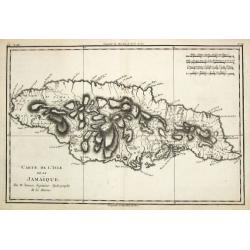
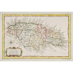
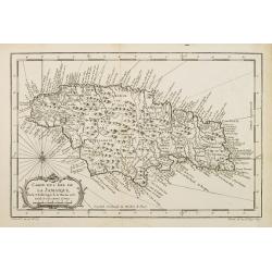
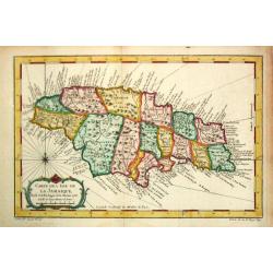
Carte de l?Isle de La Jamaique.
Jaques Nicolas Bellin (1702-720) was the most important French hydrographer of the 18th century. Sea-atlas 'Hydrographique Français' , 1756-65, atlas to accompany Prévo...
Date: Paris, 1758
Selling price: ????
Please login to see price!
Sold
Carte de L'Isle de La Jamaique..
A good engraved map of the island with rococo title cartouche lower left.
Date: Paris, 1758
Selling price: ????
Please login to see price!
Sold in 2017
Carte Réduite de l'Isle de la Martinique Dresée au Dépost des Cartes et Journaux de la Marine Pour le Service des Vaisseaux du Roy. Par ordre de M. de Moras Ministre et Secretaire d'Etat ayant le Département de la Marine.
This handsome large scale chart shows parishes, towns, plantations, windmills, roads anchorages and a few soundings. The inset shows a close up of the town and harbor of ...
Date: Paris 1758
Selling price: ????
Please login to see price!
Sold
Carte de L'Isle de La Jamaique..
A good engraved map of the island Jamaica with rococo title cartouche lower left. From l'Histoire générale des voyages .
Date: Paris 1758
Selling price: ????
Please login to see price!
Sold
Carte de L'Isle de la Guadeloupe.
A good engraved map of Guadeloupe. The geographical features are typical with somewhat exaggerated bays and inlets. From l'Histoire générale des voyages .
Date: Paris 1758
Selling price: ????
Please login to see price!
Sold
Carte du Spits-Berg..
A good engraved map of Spitsbergen. The geographical features are typical with somewhat exaggerated bays and inlets. From l'Histoire générale des voyages .
Date: Paris 1758
Selling price: ????
Please login to see price!
Sold
Carte Réduite des Mers du Nord Pour servir a l'Histoire Generale des Voyages.
General map of the Arctic Region including part of Canada, Greenland, Iceland, Scandinavia and part of the Russian shores.
Date: Paris 1758
Selling price: ????
Please login to see price!
Sold
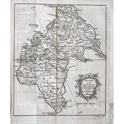
Old Map of the Continent according to the greatest diametrical Length from the Point of East Tartary to the Cape of Good Hope.
Unusual projection of Europe, Asia, and Africa. Shows major cities, regions, rivers and mountains. A woman’s face with a hat is incorporated into the title cartouche. ...
Date: London, 1758
Selling price: ????
Please login to see price!
Sold in 2013
Carte de l?Isle de La Jamaique.
Jaques Nicolas Bellin (1702-720) was the most important French hydrographer of the 18th century. Sea-atlas 'Hydrographique Français' , 1756-65, atlas to accompany Prévo...
Date: Paris, 1758
Selling price: ????
Please login to see price!
Sold
Karte von Luisiana, dem Laufe des Mississipi und den benachbarten Laendern. . .
A scarce German text edition of de l'Isles map, covering all the known United States, from the Rio del Norte (extending north almost to the Missouri headwaters) to the Gr...
Date: Leipzig, 1744 - 1758
Selling price: ????
Please login to see price!
Sold in 2011
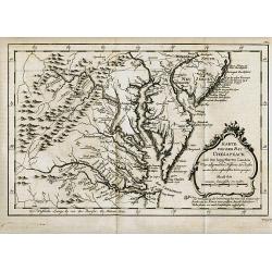
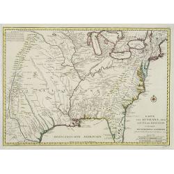
Karte von der Bay Chesapeack und den benachbarten Landen
Bellin\'s important and interesting map of the Chesapeake Bay, with excellent detail on New Jersey, Maryland, Virginia, and Pennsylvania. Indicating many cities and vill...
Date: Paris, c.1758
Selling price: ????
Please login to see price!
Sold in 2008
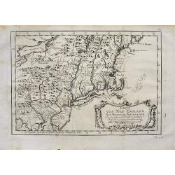
Karte von Neu England Neu Yorck und Pensilvanien.
Bellin's important and interesting map of the North-East U.S. German Edition published in "Historie der Reisen." Very detailed, showing many cities and villages...
Date: Paris, c1758
Selling price: ????
Please login to see price!
Sold in 2008
Carte Du Spits-Berg Suivant les Hollandois . . . 1758
A decorative map of Spitsbergen (Svalbard) with the adjacent islands of Franz Josef Land and Jan Mayan. The geographical features are typical with somewhat exaggerated ba...
Date: Paris, 1758
Selling price: ????
Please login to see price!
Sold in 2008
Carte Réduite des Mers du Nord Pour servir a l'Histoire Generale des Voyages.
Folding map of the Arctic Region including part of Canada, Greenland, Iceland, Scandinavia and part of the Russian shores.From l'Histoire générale des voyages. Jacques ...
Date: Paris, 1758
Selling price: ????
Please login to see price!
Sold in 2011
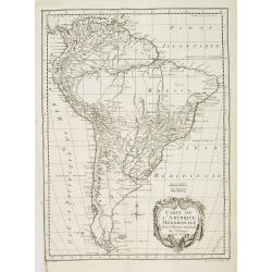
Carte de l''Amérique Méridionale..
A good engraved map of South America with rococo title cartouche lower right. From l'Histoire générale des voyages .
Date: Paris, 1758
Selling price: ????
Please login to see price!
Sold in 2015
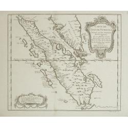
Carte de l'Isle de Sumatra Dréssée sur les Journaux des Navigateurs...
Map of Sumatra, also showing the tip of the Malay Peninsula and the Straits of Singapore. An unusually detailed map of the area, showing many coastal features, shoals, ba...
Date: Paris, 1758
Selling price: ????
Please login to see price!
Sold in 2008
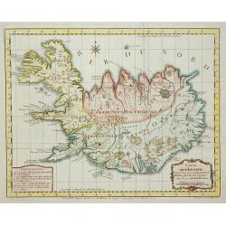
Carte de L'Islande . . .
A good engraved map of the island Iceland with rococo title cartouche lower right. From l'Histoire générale des voyages.
Date: Paris, 1758
Selling price: ????
Please login to see price!
Sold in 2011
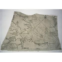
A DRAUGHT OF VIRGINA from the Capes to York in York River and to Kuiquotan or Hamton in James River.
A large fragment of this significant chart. Shows the cities of Norfolk and Hamton, many bays, islands, and depth soundings.Includes the large title cartouche, a compass ...
Date: London,Mount & Page, c1758
Selling price: ????
Please login to see price!
Sold in 2010
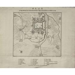
Plan du Siège formé par les Autrichiens devant la Ville de Schweidnitz, en Silesie, en 1757
Rare Military Plan of Swidnica in Silesia during the Seven Years' War by Pieter de Hondt. Showing the siege of Swidnica in 1757. After L. W. F. Von Oebschelwitz, engraved...
Date: The Hague, 1758
Selling price: ????
Please login to see price!
Sold in 2015
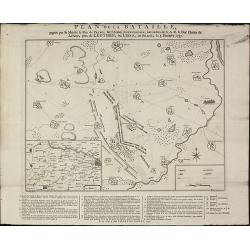
Plan de la Bataille, gagnée par Sa Majesté le Roi de Prusse, sur l'Armée Autrichienne, aux ordres de S.A.R de Duc Charles de Lorraine, près de Leuthen, ou Lissa, en Silesie, le 5. Decembre 1757
A rare military plan of Leuthen in Silesia during the Seven Years' War by Pieter de Hondt. Showing the Battle of Leuthen on 5 December 1757 during the Seven Years War. Af...
Date: The Hague, 1758
Selling price: ????
Please login to see price!
Sold in 2015
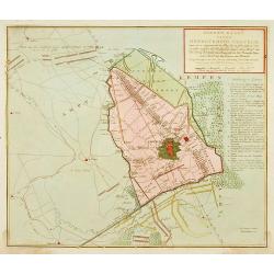
Detailed plan of Krefeld. . .
Detailed plan of Krefeld showing the battle of 23 June 1758 between Duke Ferdinand van Brunswyk and the French army under command of the Duke of Clermond. With extensive ...
Date: Amsterdam, 1758
Selling price: ????
Please login to see price!
Sold in 2019
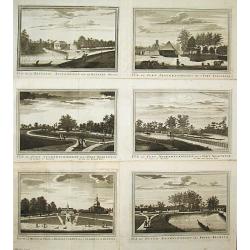
Vue de la Maison de Ville á Batavia / Vue de la Batterie Anjol / Vue du Fort Noortwyck en venant de Ryswyck / Vue du Fort noortwyck en venant de Jacatra / Vue de Poste Ryswyck / Vue du Fort Tangeran.
Jan van Schley is the engraver of the maps (by J.N. Bellin) and views in the Dutch edition of A.F. Prévost d\' Exile\'s \'Histoire Géneral des Voyages.A set of 6 engrav...
Date: Amsterdam, 1759
Selling price: ????
Please login to see price!
Sold
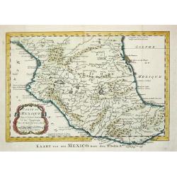
Carte de Mexique, 1754.
Jaques Nicolas Bellin (1702-720) was the most important French hydrographer of the 18th century. Sea-atlas 'Hydrographique Français' , 1756-65, atlas to accompany Prévo...
Date: Amsterdam, 1759
Selling price: ????
Please login to see price!
Sold
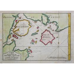
Carte de la Baye de Chin-Chew. Avec les Isles de Emowi et de Quemowi.
Jaques Nicolas Bellin (1702-720) was the most important French hydrographer of the 18th century. Sea-atlas 'Hydrographique Français' , 1756-65, atlas to accompany Prévo...
Date: Amsterdam, 1759
Selling price: ????
Please login to see price!
Sold
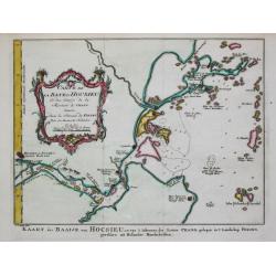
Carte de la Baye d?Hocsieu.
Jaques Nicolas Bellin (1702-720) was the most important French hydrographer of the 18th century. Sea-atlas 'Hydrographique Français' , 1756-65, atlas to accompany Prévo...
Date: Amsterdam, 1759
Selling price: ????
Please login to see price!
Sold
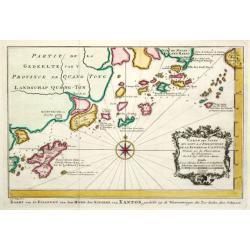
Carte des Isles... de la Rivière de Canton.
Jaques Nicolas Bellin (1702-720) was the most important French hydrographer of the 18th century. Sea-atlas 'Hydrographique Français' , 1756-65, atlas to accompany Prévo...
Date: Amsterdam, 1759
Selling price: ????
Please login to see price!
Sold
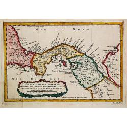
Carte de Isthme de Panama et des Provinces de Veragua, Terre Ferme, et Darien.
Jaques Nicolas Bellin (1702-720) was the most important French hydrographer of the 18th century. Sea-atlas 'Hydrographique Français' , 1756-65, atlas to accompany Prévo...
Date: Amsterdam, 1759
Selling price: ????
Please login to see price!
Sold in 2018
![[Title page] ATLAS PORTATIF DES MILITAIRES ET DES VOYAGEURS.](/uploads/cache/61305-250x250.jpg)
[Title page] ATLAS PORTATIF DES MILITAIRES ET DES VOYAGEURS.
Decorative title page by G.-L. Le Rouge, who was lieutenant in the regiment of Saxe before establishing himself as publisher, compiler and editor of maps at the "rue...
Date: Paris, 1759
Selling price: ????
Please login to see price!
Sold
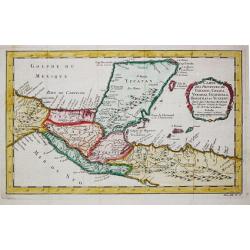
Carte des provinces des Tabasco, Chiapa, Verapaz, Guatamala, Honduras et Yucatan.
Jaques Nicolas Bellin (1702-720) was the most important French hydrographer of the 18th century. Sea-atlas 'Hydrographique Français' , 1756-65, atlas to accompany Prévo...
Date: Amsterdam, 1759
Selling price: ????
Please login to see price!
Sold
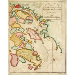
Carte del? Entrée de la Rivière de Canton.
Jaques Nicolas Bellin (1702-720) was the most important French hydrographer of the 18th century. Sea-atlas 'Hydrographique Français' , 1756-65, atlas to accompany Prévo...
Date: Amsterdam, 1759
Selling price: ????
Please login to see price!
Sold
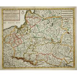
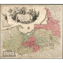
Nieuwe kaart van 't Koningkrijk Poolen.
Nice copper engraved map of the Kingdom of Poland excellently details topography, cities and villages. It is embellished with a simple compass rose. Engraved by J. Keyser...
Date: Amsterdam, 1759
Selling price: ????
Please login to see price!
Sold
Borussiae Regnum complectens Circulos Sambiensem, Natangiensem et Hockerlandiae nec non Borussia Polonica Exhibens Palatinatus Culmiensem, Marienburgensem, Pomerelliae et Varmiae
Decorative copper engraved map of Poland by T. C. Lotter. Covering the area around Dantzig (Gdansk), Elbing (Elblag) and Königsberg (Krolewiec). The map has a highly dec...
Date: Augsburg, 1759
Selling price: ????
Please login to see price!
Sold in 2008