Browse Listings
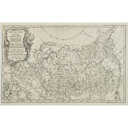
Partie de l'Empire de Russie comprise en Asie par le Sr. D'Anville. . .
Map of Russia.
Date: Paris, 1759
Selling price: ????
Please login to see price!
Sold in 2009
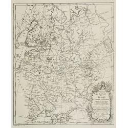
Partie de l'Empire de Russie comprise en Asie par le Sr. D'Anville. . .
Map of Russia.
Date: Paris, ca. 1759
Selling price: ????
Please login to see price!
Sold in 2009
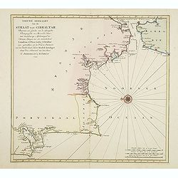
Nieuwe zeekaart van de Straat van Gibraltar..
Decorative map of Gibraltar and the coast of the Algarve (Portugal) till Lisbon. Including northern most tip of Morocco, including towns of Tangier, Ceuta and Tetuan.East...
Date: Amsterdam, 1759
Selling price: ????
Please login to see price!
Sold in 2017
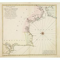
Nieuwe zeekaart van de Straat van Gibraltar. . .
Decorative map of Gibraltar and the coast of the Algarve (Portugal) till Lisbon. Including northern most tip of Morocco, including towns of Tangier, Ceuta and Tetuan.East...
Date: Amsterdam, 1759
Selling price: ????
Please login to see price!
Sold in 2013
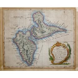
Guadeloupe, one of the Caribee Islands in the West Indies from the latest Discovery.
Guadeloupe, one of the Caribee Islands in the West Indies from the latest Discovery. By John Hinton. Published in London March 1759, in "The Universal Magazine of Kn...
Date: London 1759
Selling price: ????
Please login to see price!
Sold in 2015
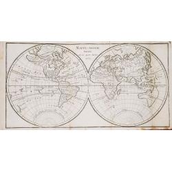
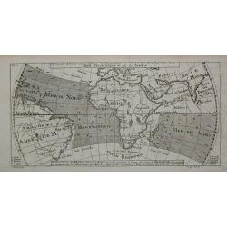
Dictionaire Géographique Universel, ou Description des Royaumes, Provinces, Villes... etc.
A very fine copy of Vosgien's geographical dictionary with a world map in two hemispheres and a map of Europe.
Date: Paris, 1759
Selling price: ????
Please login to see price!
Sold in 2019
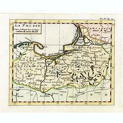
La Prusse.
Fine miniature map of Prussia, likely published by Claude Buffier. In upper right corner "Tom.III. Pag. 233.
Date: Paris, ca. 1759
Selling price: ????
Please login to see price!
Sold in 2015
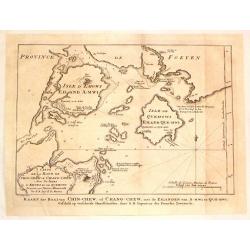
Kaart der Baai van Chin-Chew, of Chang-Chew.
This map features the Bay of Changchow in the Fukien province. The map features a floral title cartouche. The Dutch title is at the bottom.
Date: Paris, 1759
Selling price: ????
Please login to see price!
Sold in 2018
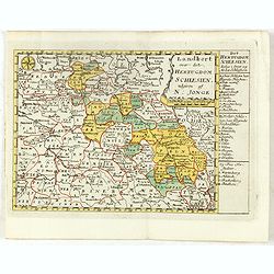
Landkort over det Hertugdom Schlesien udgiven af N : Jonge.
This scarce map of Silesia was published in a Danish atlas "Fra Holbergs Geographie" by Nikolay (Nicolai) Jonge (1727 – 1789) in Copenhagen in 1759.Including ...
Date: Copenhagen, 1759
Selling price: ????
Please login to see price!
Sold in 2016
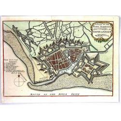
A Plan of the Town, Harbour and citadel of Havre de Grace
A handsome plan of the French port city of Havre de Grace that shows its many fortifications. A key at left locates churches, bastions, etc. Excellent detail of jetties, ...
Date: London, 1759
Selling price: ????
Please login to see price!
Sold in 2016
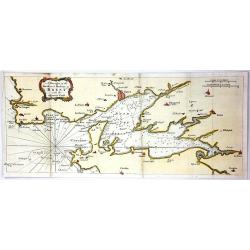
A Draught of the Road and Harbour of Brest with the Adjacent Coast
An interesting copper engraving map of France with rhumb lines and fleur-de-lys. Map extends from Le Counquet to Le Faou, detailing the coastline, anchorages and sounding...
Date: Paris, 1759
Selling price: ????
Please login to see price!
Sold in 2016
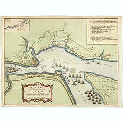
Quebek de hoofdstad van Kanada.
A handsome copper engraved map, closely copied from a similar plan by Thomas Jeffreys. The map depicts the English siege and attack on Quebec, which resulted in the city'...
Date: Amsterdam, 1759
Selling price: ????
Please login to see price!
Sold in 2019
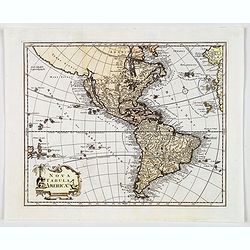
Nova Tabula Americae.
A rare map of the Americas showing California as an island, published by Georg Christoph Kilian. Map gives some very good detail, however, Brazil is still distorted, Cali...
Date: Augsburg, 1759
Selling price: ????
Please login to see price!
Sold in 2019
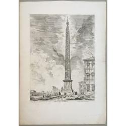
Obelisco Egizio.
Obelisco Egizio (Egyptian obelisk erected by Pope Sixtus V on the Piazza di San Giovanni in Laterano) is a wonderful black and white etching by the master of architectur...
Date: Rome, 1759
Selling price: ????
Please login to see price!
Sold in 2020
![[Portrait of Jan Wagenaar with title page] Amsterdam in Zyne opkomst, aanwas, Geschiedenissen . . .](/uploads/cache/44990-250x250.jpg)
[Portrait of Jan Wagenaar with title page] Amsterdam in Zyne opkomst, aanwas, Geschiedenissen . . .
Portrait of the historian Jan Wagenaar, engraved by Jacob Houbraken, in 1766 after a painting by Jacobus Buys. Together with title page from "Amsterdam in zyne opkom...
Date: Amsterdam, 1760
Selling price: ????
Please login to see price!
Sold in 2019
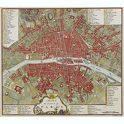
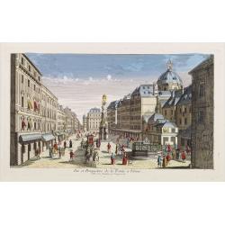
A plan of the city of Paris.
Uncommon plan of Paris with a very decorative title cartouche with globe, sun, etc. A numbered key (1-78) to most important buildings and streets in town. Engraved by J. ...
Date: London 1760
Selling price: ????
Please login to see price!
Sold in 2019

Vedute di Roma Veduta del Tempio ottangolare di Minerva Medica.
Giovanni Battista Piranesi's 'Veduta del Tempio ottangolane di Minerva Medica'. An original etching from 'Vedute di Roma' by Giovanni Battista Piranesi, ca 1760. Signed ...
Date: Paris, ca 1760
Selling price: ????
Please login to see price!
Sold in 2020
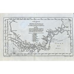
Carte Reduite Du Détroit de Magellan. . .
Bellin's important and interesting map of the Straits of Magellan and parts of Tierra del Fuego, dated 1753. It extends from Cap des Vierges to Cap de la Victoire, and in...
Date: Paris, ca. 1760
Selling price: ????
Please login to see price!
Sold in 2021

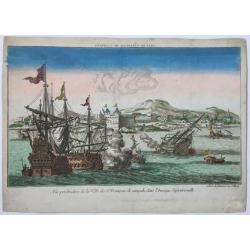
Attaque de deux bastions les breches faites par le mineur.
Optical view. Reversed title. Print of Barcelona’s siege in 1714. (From Hyacinthe Rigaud). Ink annotations in the margins.
Date: Augsburg, ca. 1760
Selling price: ????
Please login to see price!
Sold in 2020
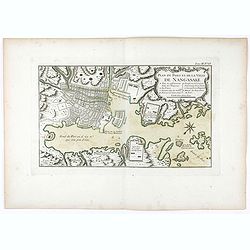
Plan du port et de la ville de Nangasaki.
Attractive and well detailed plan of Nagasaki, large title cartouche with reference key to principal points of interest. Deshima is central to the map.Jacques Nicolaas Be...
Date: Paris, 1760
Selling price: ????
Please login to see price!
Sold in 2020
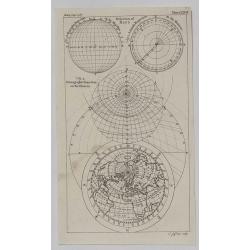
North Polar Regions.
A detailed little map of the North Polar Regions by Thomas Jeffreys in 1760. It features the Orthographic, Azimuth and Stereographic Projections as well as the world fro...
Date: London, 1760
Selling price: ????
Please login to see price!
Sold in 2020
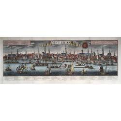
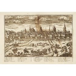
Amsterdam.
Very large size general panoramic view of the city from the water ('het IJ') with the harbour up front. With key 1-30 below the view, in Dutch (bottom left), Latin (botto...
Date: Augsburg, 1740-1760
Selling price: ????
Please login to see price!
Sold in 2020
Vue perspective de la Ville de St. Francois de campeche dans l'Amerique Septentrionalle.
An optica print with a view on the city of Campeche, Yucatan, Mexico, several ships in the foreground. Published by Jean-François Daumont, Paris, ca. 1760.
Date: Paris, ca. 1760
Selling price: ????
Please login to see price!
Sold in 2020
![Carte Reduite de L'Isle de Cube [Cuba]. Dressee au Depoit des Cartes et Plans de la Marine. . .](/uploads/cache/84494-250x250.jpg)
Carte Reduite de L'Isle de Cube [Cuba]. Dressee au Depoit des Cartes et Plans de la Marine. . .
A well engraved and highly detailed nautical chart of Cuba. It shows soundings, anchorage's, channels, shoals, navigational sightings. Also shows small parts of Florida a...
Date: Paris, 1760
Selling price: ????
Please login to see price!
Sold in 2021
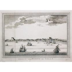
Gezicht van Punto de Galle. Plus 2 other views of the area.
[Antique view of Galle] Gezicht van Punto de Galle. Jan van Schley is the engraver of the maps (by J.N. Bellin) and views in the Dutch edition of A.F. Prévost d' Exile's...
Date: Amsterdam, ca 1760
Selling price: ????
Please login to see price!
Sold in 2020
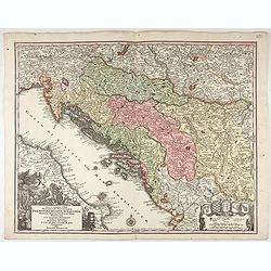
Nova et accurata.. Dalmatiae, Croatiae, Sclovoniae, Bosniae. . .
A finely engraved and large detailed map including the western part of the river Donau. Two decorative cartouches adorn the lower corners of the map. One with coats of ar...
Date: Augsburg, 1760
Selling price: ????
Please login to see price!
Sold in 2023
![[Lot of 6 maps of Italy]](/uploads/cache/20941-(1)-250x250.jpg)
[Lot of 6 maps of Italy]
Claude Buy de Mornas (dl 1783), géographe du roi (1764). Atlas Méthodique et Elémentaire de Géographie et d' Histoire, 1761, Atlas Historique et Géographique, 1762.�...
Date: c. 1760
Selling price: ????
Please login to see price!
Sold in 2022
![[A lot of 5 map of Guyana.] Land-kaart van Cayenne.](/uploads/cache/20452-250x250.jpg)
[A lot of 5 map of Guyana.] Land-kaart van Cayenne.
An attractive map of the island and settlement of Cayenne, with an inset picturing a plan of the town and fort of Cayenne. Izaak Tirion (d. 1769) Amsterdam publisher. H...
Date: Amsterdam, c. 1760
Selling price: ????
Please login to see price!
Sold in 2022
![[Lot of 10 maps /views of the Caribbeans], Terre Ferme, Isles Antilles et N.lle Espagne.](/uploads/cache/18346-(1)-250x250.jpg)
[Lot of 10 maps /views of the Caribbeans], Terre Ferme, Isles Antilles et N.lle Espagne.
Louis Brion de la Tour (1756-1823), ' Atlas Géneral, Civil et Ecclésiastique', 1766, ' Atlas Général', 1790-98. Louis Charles Desnos (fl.1750-70), Le Rouge's 'Atlas...
Date: Paris, c. 1760
Selling price: ????
Please login to see price!
Sold in 2022
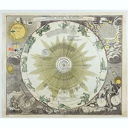
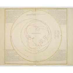
Systema solare et Planetarium..
One of J.G.Doppelmayr's celestial charts, appearing in Homann's Atlas Coelestis.It depicts the system of Copernicus with the orbits of the planets and the twelve constell...
Date: Nuremberg, 1760
Selling price: ????
Please login to see price!
Sold in 2023
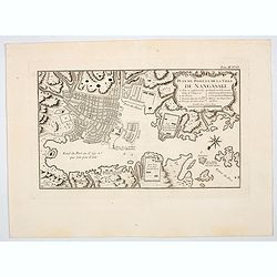
Plan du port et de la ville de Nangasaki.
An attractive and detailed plan of Nagasaki, with a large title cartouche with a reference key to principal points of interest. Deshima is central to the map.Jacques Nico...
Date: Paris, 1760
Selling price: ????
Please login to see price!
Sold in 2023
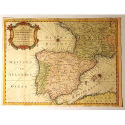
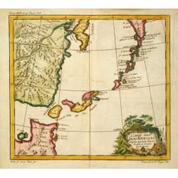
A New and Accurate Map of the Kingdoms of Spain, Portugal and Part of France, The Islands of Majorca, Minorca &c.
Produced for “Universal Magazine” by J. Hinton. It was engraved by Richard William Seale (1703-1762). The map features an attractive rococo cartouche and compass ros...
Date: London, ca. 1760
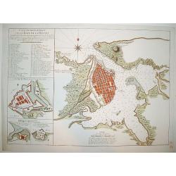
Carte Hydrographique de la Baye de la Havane
A beautifully engraved and detailed chart of the bay of Havana and plan of the city itself. Includes three inset plans of Havana's principal fortifications and a 45 point...
Date: Paris, ca 1760
Selling price: ????
Please login to see price!
Sold
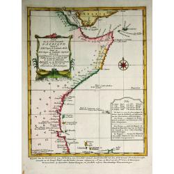
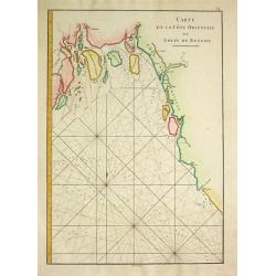
Carte De la Coste Orientale d' Afrique.
Jaques Nicolas Bellin (1702-720) was the most important French hydrographer of the 18th century. Sea-atlas 'Hydrographique Français' , 1756-65, atlas to accompany Prévo...
Date: Amsterdam, c. 1760
Selling price: ????
Please login to see price!
Sold in 2008
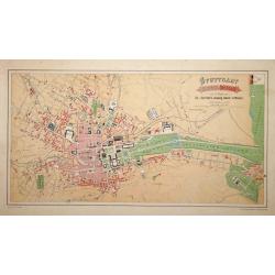
Stuttgart 1846 u. 1871.
A very detailed plan of Stuttgart. Showing the situation of 1846 and the expansion of 1871. Lithographed by H.A.Schurath and printed by "Dampfsnellpressendruck v.A G...
Date: Augsburg 1760
Selling price: ????
Please login to see price!
Sold
![Two maps and a print of Switzerland. [3 items].](/uploads/cache/14381-250x250.jpg)
Two maps and a print of Switzerland. [3 items].
Uncommon map 38x61cm) centered on Lake Lucerne, with the Alps in the back ground. Engraved by Charles Nicolas Dauphin de Beauvais (1730-1785)WITH: a map "Carte g&...
Date: Frankfurt 1623-78/ Paris 1760
Selling price: ????
Please login to see price!
Sold

La Tour de Porcellaine à Nanking.
A well-known publisher of optical prints, established in Augsburg. After a design by P.van Blankaert.In the eighteenth and nineteenth centuries there were many popular sp...
Date: Augsburg 1760
Selling price: ????
Please login to see price!
Sold
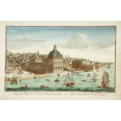
A view of the Palace of the King of Portugal at LISBONE.
One of the lesser-known publishers of optical prints, established in Paris.In the eighteenth and nineteenth centuries there were many popular speciality establishments in...
Date: Paris, ca. 1760
Selling price: ????
Please login to see price!
Sold in 2017
Lille.
"A very RARE panoramic view of the city of Lille, including a numbered legend in both lower corners. The plate is numbered in black pencil in upper right corner. Pub...
Date: Paris, 1760
Selling price: ????
Please login to see price!
Sold
Bourdeaux.
"A very RARE panoramic view of the city of Bordeaux, including a numbered legend in both lower corners. The plate is numbered in black pencil in upper right corner. ...
Date: Paris, 1760
Selling price: ????
Please login to see price!
Sold
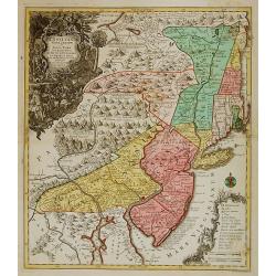
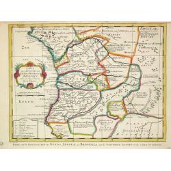
Pensylvania, Nova Jersey et Nova York..
One of the few maps to concentrate on this area and one of the most bizarre maps of North America ever published. It was based on a very rare map by Lewis Evans published...
Date: Augsburg c.1760
Selling price: ????
Please login to see price!
Sold
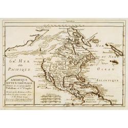
Amérique Septentrionale divisée en ses principales..
A finely engraved map of North America, prepared by J.B.Nolin. The map is most notable for it's depiction of Mer de L'Quest or Sea of the West, a great sea, easily the si...
Date: Paris c.1760
Selling price: ????
Please login to see price!
Sold
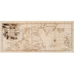
Eine neue karte von den Gegenden 1746 und 1747 eine Nord-Westliche Durchfahrt..
Uncommon map of Hudson, Great Lakes and northern Atlantic, showing the tracks of Captain Heinrich Ellis from London to the Hudson.
Date: Germany 1760
Selling price: ????
Please login to see price!
Sold
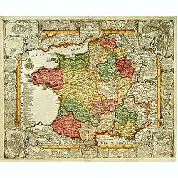
Le Royaume de France et les conquetes de Louis le Grand.
Engraved by J.Christofle Steinberger. RARE and very decorative map of France surrounded with 20 insets of town plans : [1.] Philisbourg: [2.] Mons: [3.] Longwy: [4.] Homb...
Date: Augsburg 1760
Selling price: ????
Please login to see price!
Sold
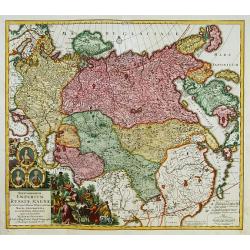
Imperium Russiae Magnae..
With decorative title cartouche in lower left corner. Including the Asian part of Russia, China, Taiwan and part of Japan.
Date: Augsburg 1760
Selling price: ????
Please login to see price!
Sold
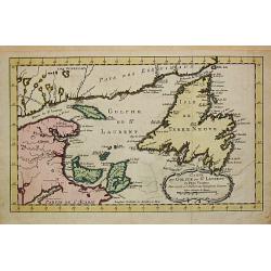
Carte du Golphe de St. Laurent et Pays Voisins.
Jaques Nicolas Bellin (1702-720) was the most important French hydrographer of the 18th century. Sea-atlas 'Hydrographique Français' , 1756-65, atlas to accompany Prévo...
Date: Paris, c. 1760
Selling price: ????
Please login to see price!
Sold
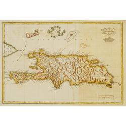
The island of Hispaniola called by the French St.Domingo..
The much contested island of Hispaniola at the height of the French side's prosperity, from Jeffery's The Natural and Civil History of the French Dominions in North and S...
Date: London 1760
Selling price: ????
Please login to see price!
Sold

4e Vue d'Optique../..St Pierre de Rome.
So-called optical print of the interior of the Basilica Saint-Pierre de Rome.Daumont was a well-known publisher of optical prints, established in Paris. In the eighteenth...
Date: Paris, 1760
Selling price: ????
Please login to see price!
Sold in 2019
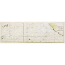
A Chart of the PACIFIC OCEAN..
Showing in the left southern coastline of Japan and eastern coastline of Philippines. To the right Americas West Coast from Acapulco up to Los Farollones. Showing tracks ...
Date: London, 1760
Selling price: ????
Please login to see price!
Sold in 2010
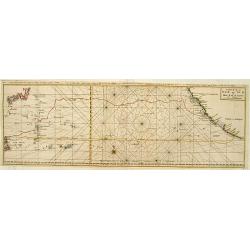
Carte de la Mer du Sud ou Mer Pacifique..
Showing in the left southern coastline of Japan and eastern coastline of Philippines. To the right Americas West Coast from Acapulco up to Los Farollones. Showing tracks ...
Date: France c.1760
Selling price: ????
Please login to see price!
Sold
Répresentation du cours ordinaire des Vents de Traverse, qui règnent le long des côtes dans la Mer Atlantique & celle des Indes.
Jaques Nicolas Bellin (1702-720) was the most important French hydrographer of the 18th century. Sea-atlas 'Hydrographique Français' , 1756-65, atlas to accompany Prévo...
Date: Paris, c. 1760
Selling price: ????
Please login to see price!
Sold
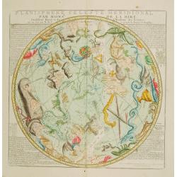
Planisphere celeste meridional..
Beautiful celestial chart of the southern skies by the well-known French astronomer, Philippe de La Hire. Updated by N. de Fer, published by Desnos. Several non-Ptolemaic...
Date: Paris 1760
Selling price: ????
Please login to see price!
Sold
Carte de la Cote Orientale du Golfe de Bengale
A French sea chart from 'Le Depot de la marine", depicting the most-northern part of the Gulf of Bengalen.
Date: Paris, c. 1760
Selling price: ????
Please login to see price!
Sold
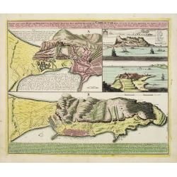
Neuester und exacter Plan .. von Gibraltar..
Scarce decorative plan of Gibraltar with fine views of the mount and Cidix. With a numbered key to the principal places in town.
Date: Nuremberg 1760
Selling price: ????
Please login to see price!
Sold
Ephemerides en figures conformes aux ephemerides..
Uncommon chart of an eclipse of the Sun, Mercurius, Venus, Mars in the years of 1751 and 1752. The schedule was prepared by l'Abbé André Brancas-Villeneuve a French cos...
Date: Nuremberg 1760
Selling price: ????
Please login to see price!
Sold
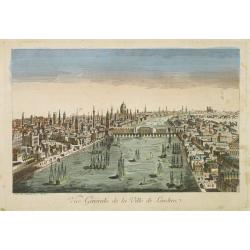
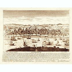
Vue générale de la ville de Londrea.
So-called optical print of London. The view is taken from a bridge on the Thames River and depicts several ships in the river and a great skyline.Daumont was a well-known...
Date: Paris 1760
Selling price: ????
Please login to see price!
Sold
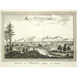
Vue de Peking, tirée de Nieuhof.
A view of Peking.
Date: Amsterdam, c. 1760
Selling price: ????
Please login to see price!
Sold
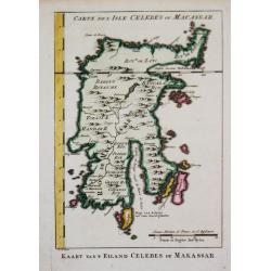
Kaart van 't Eiland Celebes of Makassar.
Jaques Nicolas Bellin (1702-720) was the most important French hydrographer of the 18th century. Sea-atlas 'Hydrographique Français' , 1756-65, atlas to accompany Prévo...
Date: Amsterdam, c. 1760
Selling price: ????
Please login to see price!
Sold
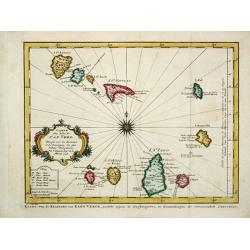
Carte des Isles du Cap Verde.
Jaques Nicolas Bellin (1702-720) was the most important French hydrographer of the 18th century. Sea-atlas 'Hydrographique Français' , 1756-65, atlas to accompany Prévo...
Date: Amsterdam, c. 1760
Selling price: ????
Please login to see price!
Sold
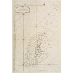
Carte des Isles Kouriles.
An attractive and unusual map of the Kuriles Islands and the northern coast of Hokkaido. The map includes numerous inaccuracies and fanciful names for a number of the isl...
Date: Paris, c. 1760
Selling price: ????
Please login to see price!
Sold in 2020
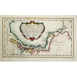
Carte réduite du Détroit de Magellan
Jaques Nicolas Bellin (1702-720) was the most important French hydrographer of the 18th century. Sea-atlas 'Hydrographique Français' , 1756-65, atlas to accompany Prévo...
Date: Amsterdam, c. 1760
Selling price: ????
Please login to see price!
Sold
Carte . . . Congo, Angola et Benguela.
A map of the Congo and Angola as far south as Cape Negro.
Date: Amsterdam, c. 1760
Selling price: ????
Please login to see price!
Sold in 2009
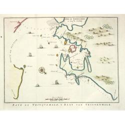
Baye de Trinquemale.
Jan van Schley is the engraver of the maps (by J.N. Bellin) and views in the Dutch edition of A.F. Prévost d' Exile's 'Histoire Géneral des Voyages.A map of Koddiyar Ba...
Date: Amsterdam, c. 1760
Selling price: ????
Please login to see price!
Sold
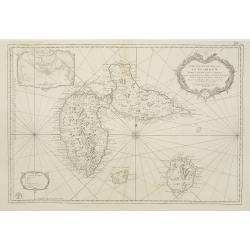
Carte de l'Isle de la Grenade..
This chart shows the island Grenada. It contains an inset coastal profile and numerous rhumb linesJacques Nicolas Bellin (1703-1772) was one of the most important and pro...
Date: Paris 1760
Selling price: ????
Please login to see price!
Sold
Carte Reduite des Isles de la Guadeloupe Marie Galante et les Saintes..
Superb large-scale sea chart with great detail of parishes, forts, towns, settlements, anchorages and topography. Includes Guadeloupe, Isles de Saintes and Marie Galante ...
Date: Paris 1760
Selling price: ????
Please login to see price!
Sold in 2008

Tabula comitatus Hollandiae. . .
Fine map of the provinces of North and South Holland. In upper left hand corner an inset with the islands of Texel and Vlieland.
Date: Augsburg 1760
Selling price: ????
Please login to see price!
Sold in 2024
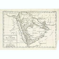
Carte de l'arabie, rédigée en grande partie..
Map of South Arabia based on the journey of the famous Danish explorer Carsten Niebuhr in this area. Showing the ruins of Babylon in actual Iraq and the ruins of Persepol...
Date: Paris, 1760
Selling price: ????
Please login to see price!
Sold
Vue et Perspective de la Trinité a Vienne.
Decorative perspective view of a square in Vienna centered on the column which represents the Trinity. Published by Charpentier, who was active in rue St.Jacques in Paris...
Date: Paris, 1760
Selling price: ????
Please login to see price!
Sold in 2022

65e. Vüe d'Optique Représentant Le Palais de Cesar dans le Faubourg a Vienne appellé Favorita.
So-called optical print of a palace in Vienna, by Daumont who was a well-known publisher of optical prints, established in Paris.In the eighteenth and nineteenth centurie...
Date: Paris 1760
Selling price: ????
Please login to see price!
Sold in 2016

14e. Vüe d'Optique Representant La Grande Place de Petersbourg.
So-called optical print illustrating a perspective view of the portico of a Palace in Saint Petersburg. Published by Daumont, a well-known publisher of optical prints, es...
Date: Paris, 1760
Selling price: ????
Please login to see price!
Sold in 2017

Vüe Méridionale de la Place Royale de Nancy.
So-called optical print illustrating the southern side of the Royal Square in Nancy. Published by Daumont, active at rue St.Martin, who was a well-known publisher of opti...
Date: Paris 1760
Selling price: ????
Please login to see price!
Sold in 2011

Vue perspective de la Place Royale de Nancy 1760.
So-called optical print illustrating a perspective view of the Royal Square in Nancy.Mondhare, active at rue St.Jacques a l'Hotel Saumur, was a well-known publisher of op...
Date: Paris, 1760
Selling price: ????
Please login to see price!
Sold in 2011
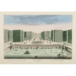
54e Vue d'Optique Representant Les Cascades de Versailles.
So-called optical print, illustrating a water basin with fountains in the gardens of Versailles.In the eighteenth and nineteenth centuries there were many popular special...
Date: Paris 1760
Selling price: ????
Please login to see price!
Sold in 2015

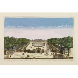
Vue du grand Bassin au bas des Tuilleries d'où l'on decouvre la place de Louis XV. Les Champs Elisée tel que cela doit être executé
So-called optical print illustrating a perspective view of the big basin in the Tuileries gardens, in Paris.Mondhare was a well-known publisher of optical prints, establi...
Date: Paris 1760
Selling price: ????
Please login to see price!
Sold
A view of Eugen princip Palace of Vien. / Vuë du Superbe Palais du Prince Eugene a Vienne.
Optical view of a square in Vienna, by Daumont who was a well-known publisher of optical prints, established in Paris.In the eighteenth and nineteenth centuries there wer...
Date: Paris 1760
Selling price: ????
Please login to see price!
Sold in 2016
Vue perspective de la Ville de Warsovie Capitale de la Marsovie sur la Wistule en Pologne.
So-called optical print illustrating a perspective view of Warsaw, namely the buildings overlooking the river Wisla.Mondhare was a well-known publisher of optical prints,...
Date: Paris 1760
Selling price: ????
Please login to see price!
Sold

Vue du Chateau de Maisons du Côté de l'Avenue..
Uncommon, so-called optical print illustrating a perspective view of a castle, probably Fontainebleau.In the eighteenth and nineteenth centuries there were many popular s...
Date: Paris, 1760
Selling price: ????
Please login to see price!
Sold in 2009
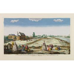
A view of the Road and Water-Works of Chelsea, with a Prospect of London.
So-called optical print illustrating the Somerset House with St. Mary's Church in the Strand London as indicated in the title. Shows figures walking and seated on the gro...
Date: Paris 1760
Selling price: ????
Please login to see price!
Sold

Vüe de la Maison Royalle de choisy du Côté du Jardin
So-called optical print illustrating a perspective view of a royal mansion in Choisy, near Paris.In the eighteenth and nineteenth centuries there were many popular specia...
Date: Paris, 1760
Selling price: ????
Please login to see price!
Sold in 2010
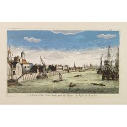
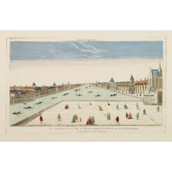
A View of the Tower taken upon the Thames. / La Rade de Londres.
So-called optical print illustrating a perspective view of the Tower as well as part of the Docks of London.In the eighteenth and nineteenth centuries there were many pop...
Date: London, c.1760
Selling price: ????
Please login to see price!
Sold