Browse Listings
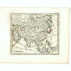
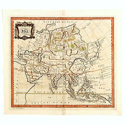
L'Asie Divisée selon ses differens Etats.
Small detailed map of Asia. From Atlas Portatif Universel, by Robert de Vaugondy.Page 160 outside border top right. State 2, title changed: "Par le Sr. Robert de Vau...
Date: Paris, 1754
Selling price: ????
Please login to see price!
Sold in 2017
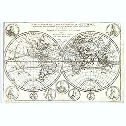
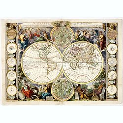
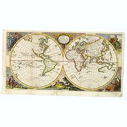
Mappe-Monde ou carte generale de la terre.
World map in two hemispheres prepared by de Lisle.
Date: Paris, ca. 1754
Selling price: ????
Please login to see price!
Sold in 2016
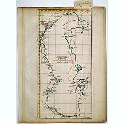
Essai d'une Nouvelle Carte de la Mer Caspienne.
Useful map of the Caspian Sea by the French cartographer d'Anville.
Date: Paris, ca. 1754
Selling price: ????
Please login to see price!
Sold in 2016
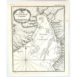
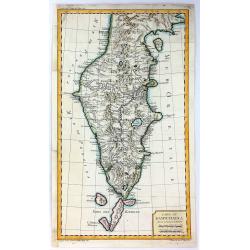
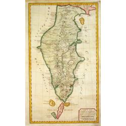
Carte du Golphe de Cambaye.
A quaint little map of India, featuring the Gulf of Cambay (Gulf of Khambhat) India, published in “Le Petit Atlas Martime” published by Bellin in 1764. Featuring a f...
Date: Paris, 1754
Selling price: ????
Please login to see price!
Sold in 2016
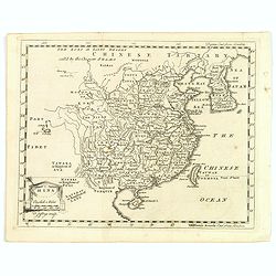
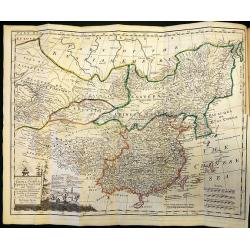
China.
A nice mid-eighteenth century map of China, extending from the island of Haynan in the south, to the Kobi Desert in the north, from Lake Puka in Tibet in the west to Kore...
Date: London, ca. 1754
Selling price: ????
Please login to see price!
Sold in 2017
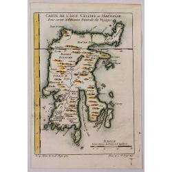
Carte de L'Isle Celebes ou Macassar.
A fine little copper engraved map of Celebes Island, Makassar.
Date: Paris, 1754
Selling price: ????
Please login to see price!
Sold in 2018
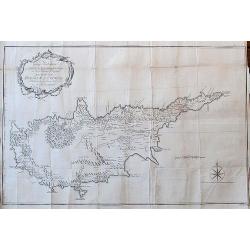
To George Wakeman Esq, Consul for his Majesty the King of Great Britain in the Island of Cyprus. This Map of the Island of Cyprus is dedicated by his friend and servant A. Drummond.
A rare large scale map Cyprus. It is one of the most important cartographic sources of Cyprus during the Turkish occupation in the 18th century. Curiously, some place-nam...
Date: London, 1754
Selling price: ????
Please login to see price!
Sold in 2018
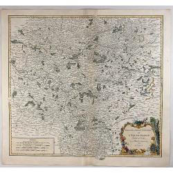
Gouvernement General de L'Isle de France Divise par Pays.
Showing the region around Paris, France, with hand colored outlines and decorated cartouche, by Vaugondy, in 1754. Written in French. Map is detailed and includes illustr...
Date: Paris, 1754
Selling price: ????
Please login to see price!
Sold in 2018
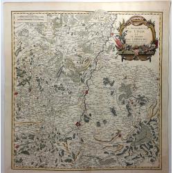
La Principaute de Liege et le Duche de Limbourg.
A scarce 1754 map of Liege and Limbourg, Belgium by Robert de Vaugondy. It covers parts of northeastern Belgium and southern Netherlands along with neighbouring Germany.O...
Date: Paris , 1754
Selling price: ????
Please login to see price!
Sold in 2019
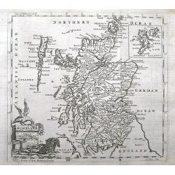
Scotland.
A small and detailed copper engraved map of Scotland. Names many towns, rivers, loughs, and even small islands like North Rona, St. Kilda, etc...Decorated with a title ca...
Date: London, ca 1754
Selling price: ????
Please login to see price!
Sold in 2018
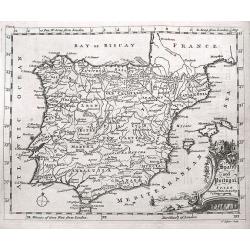
Spain and Portugal.
A small interesting copper engraved map of the Iberian peninsula. It names many towns, rivers, and includes the Balearic Islands. Extends to show also Tanger and Ceuta.De...
Date: London, ca 1754
Selling price: ????
Please login to see price!
Sold in 2018
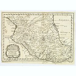
Carte de L'Empire du Mexico.
A good engraved map of Mexico, with rococo title cartouche lower left. From l'Histoire générale des voyages. North to Durango and south to beyond Guaxaca.
Date: Paris, 1754
Selling price: ????
Please login to see price!
Sold in 2020
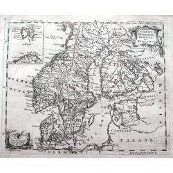
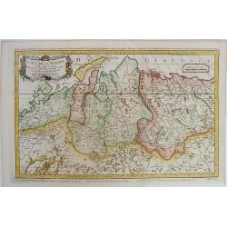
Sweden, Denmark, Norway and Finland.
A small but detailed copper engraved map of Scandinavia, including the Baltic. A small inset map shows Spitsbergen (here named East Greenland) and the North Cape. Names m...
Date: London, ca 1754
Selling price: ????
Please login to see price!
Sold in 2020
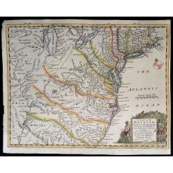
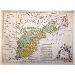
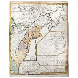
A Map of the British American Plantations extending from Boston in New England to Georgia. . .
A nice example of this early map of the British Colonies, issued just one year prior to the seminal map of John Mitchell. The map is based largely upon the work of D'Anvi...
Date: London, 1754
Selling price: ????
Please login to see price!
Sold in 2019
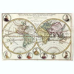
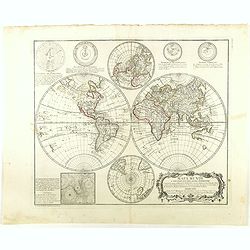
Mappe-Monde ou carte generale de la terre.
World map in two hemispheres prepared by de Lisle. The hemispheres are surrounded by small portraits of nine explorers: Père Tachard SJ, de la Salle, Dampier, Magellan, ...
Date: Paris, ca. 1754
Selling price: ????
Please login to see price!
Sold in 2023
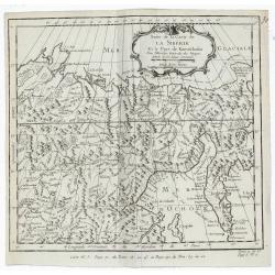
Carte De La Siberie Et des Pays voisins pour servir a l'Histoire general des Voyages . . .
Large detailed copper engraved map centering on Siberia, from Nouvelle Zemle and the Arctic Circle, down to Mer Caspiene (Caspian Sea) and Mer d'Aral. The map with captio...
Date: Paris, 1754
Selling price: ????
Please login to see price!
Sold in 2019
Suite de la Carte de la Siberie Et le Pays de Kamtschatka.
A detailed 1754 Bellin engraved map of eastern Siberia above and below the Arctic Circle, showing the Sea of Okhotsk, the Kamchatka Peninsula, and Sakhalin Island. The ma...
Date: Paris, 1754
Selling price: ????
Please login to see price!
Sold in 2019
Carte des Isles Kouriles Diapres la Carte Russe. . .
A striking map of Northern Japan and the contiguous islands and coastline. Features a decorative title cartouche. Jacques Nicolas Bellin (1703-1772) was one of the most i...
Date: Paris, 1754
Selling price: ????
Please login to see price!
Sold in 2020
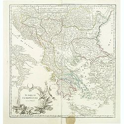
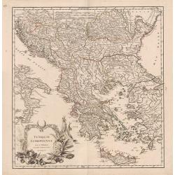
Turquie Européenne.
A beautiful map of Greece, with the coast of Turkey from De Vaugondy’s 1752 Atlas Universal. Depicts the whole of Greece from Bosnia and Croatia east to through Bulgari...
Date: Paris, 1755
Selling price: ????
Please login to see price!
Sold in 2011
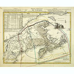
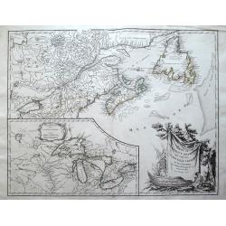
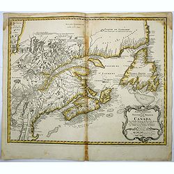
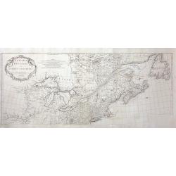
Partie Orientale du Canada. . .
A Parisian edition of Thomas Jeffery's map of Nova Scotia and Cape Britain. At the time of publication, 1755, Great Britain and France were in dispute over their boundary...
Date: Paris, 1755
Selling price: ????
Please login to see price!
Sold in 2012
![[3 Maps] Latium, Italia propria, Magna Graecia Italiae antiquae pars.](/uploads/cache/92133-250x250.jpg)
[3 Maps] Latium, Italia propria, Magna Graecia Italiae antiquae pars.
Map 1 Latium Roma and its environs. Good condition strong impression, Map 2 Italia propria condition one small margin tear top left strong impression, Map 3 Magna Graec...
Date: Leipzig, 1755
Selling price: ????
Please login to see price!
Sold in 2013
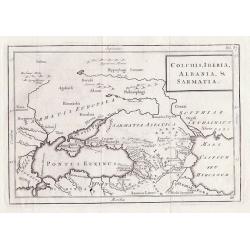
Colchis, Iberia, Albania & Sarmatia.
Outline map shows the Black Sea, Ukraine, Turkey, parts of Russia and adjacent areas, Christoph Cellarius, 17955 for "Geographia Antiqua".
Date: Leipzig, 1755
Selling price: ????
Please login to see price!
Sold in 2012
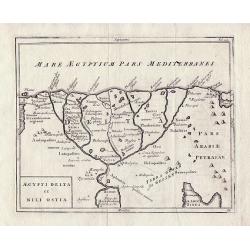
Aegypti Delta et Nili Ostia.
The Nile Delta by Christoph Cellarius from 'Geographia Antiqua'.
Date: Leipzig, 1755
Selling price: ????
Please login to see price!
Sold in 2013
![[Two maps] Aegyptus Marmarica Et Cyrenaica\' and \'Africa Interior.](/uploads/cache/92137-250x250.jpg)
[Two maps] Aegyptus Marmarica Et Cyrenaica\' and \'Africa Interior.
Present day Egypt from the Nile Delta and the Red Sea west to Libya.'Africa Interior' continues South to the source of the Nile with the White Nile and the Blue Nile in t...
Date: Leipzig 1755
Selling price: ????
Please login to see price!
Sold in 2013
![[Two maps] Numidia et Mauretania\' and \'Syrtes Byzacium et Africa Propria.](/uploads/cache/92139-250x250.jpg)
[Two maps] Numidia et Mauretania\' and \'Syrtes Byzacium et Africa Propria.
The two maps cover the area from The Atlantic Ocean and Southern Spain in the West through to Libya in the East and the Mediterranean, Malta, and Sicily to the North, by ...
Date: Leipzig, 1755
Selling price: ????
Please login to see price!
Sold in 2013
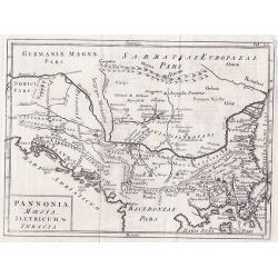
Pannonia Moesia Illyricum & Thracia.
Pannonia Moesia Illyricum & Thracia by Christoph Cellarius c1755 from his Geographia Antiqua. Highly detailed map of ancient Greece.
Date: Leipzig, 1755
Selling price: ????
Please login to see price!
Sold in 2014
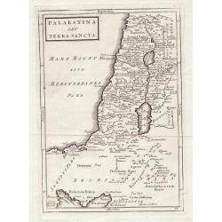
Palaestina S.EU Terra Sancta.
Map of Palaestina by Christoph Cellarius, from "Geographia Antiqua". Highly detailed map of the area.
Date: Leipzig, 1755
Selling price: ????
Please login to see price!
Sold in 2012
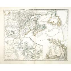
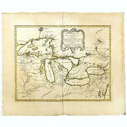
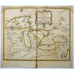
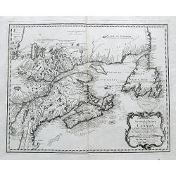
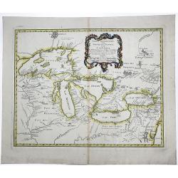
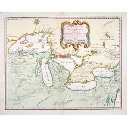
Partie de l'Amerique Septent? qui comprend la Nouvelle France ou le Canada. . .
Robert de Vaugondy's superb map of French Canada with an inset on the lower left of the still not completely defined Great Lakes.The highly decorative title cartouche fea...
Date: Paris, 1755
Selling price: ????
Please login to see price!
Sold in 2012
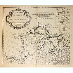
Canada Louisiane et Terres Angloises.
The northwest sheet of a four-sheet map featuring the Great Lakes and upper Mississippi River. Large, decorative cartouche designed by Gravelot. The map was based in part...
Date: Paris, 1755
Selling price: ????
Please login to see price!
Sold in 2012
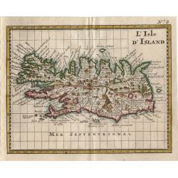
L Isle D\'Island
Small map of Iceland from Discours sur L'Histoire Universelle…
Date: Amsterdam 1755
Selling price: ????
Please login to see price!
Sold in 2014
![[Two maps] Tatariae Sinensis mappa Geographica... [together with] Regni Sinae vel Sinae propriae. . .](/uploads/cache/33797-250x250.jpg)
[Two maps] Tatariae Sinensis mappa Geographica... [together with] Regni Sinae vel Sinae propriae. . .
Tatariae Sinensis mappa Geographica A fine large-scale map derived from d'Anville and prepared by Johann Tobias Mayer . Including far western China and Mongolia, Japan, K...
Date: Nuremberg, 1755
Selling price: ????
Please login to see price!
Sold in 2013
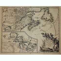
Partie de l\'Amerique septent? Qui comprend la nouvelle France. . .
A fine copy of this map of New Foundland, Nova Scotia and the course of the St. Lawrence to Lake Ontario in a fourth state.An inset shows Bellini's famous and important m...
Date: Paris, 1755
Selling price: ????
Please login to see price!
Sold in 2013
Turquie Européenne.
A beautiful map of Greece, with the coast of Turkey from De Vaugondy’s 1752 Atlas Universal. Depicts the whole of Greece from Bosnia and Croatia east to through Bulgari...
Date: Paris, 1755
Selling price: ????
Please login to see price!
Sold in 2013
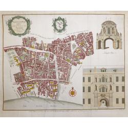
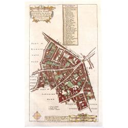
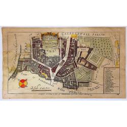
Farringdon ward without with it's division into parishes according to a new survey.
This plan was published in William Maitland's "History of London from its Foundation to the Present Time." The plan's title features in a cartouche at the top l...
Date: London, 1755
Selling price: ????
Please login to see price!
Sold in 2015
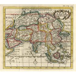
Asia
Detailed map of Asia engraved by John Gibson for "The Gentleman's Magazine", founded by visionary Edward Cave, was the world's first monthly general interest ma...
Date: London, ca. 1755
Selling price: ????
Please login to see price!
Sold in 2015
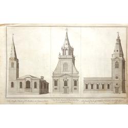
10 Original antique copper engravings For William Maitlands
An attractive set of "The Churches", copperplate prints, engraved by Benjamin Cole, from William Maitland's "History of London" 1753-56. St Swithin Ca...
Date: London, 1755
Selling price: ????
Please login to see price!
Sold in 2016
Partie de l'Amerique Septent? qui comprend la Nouvelle France ou le Canada...
Vaugondy's important map of French Canada with a large inset of the Great Lakes.Decorated with a large title cartouche features the title draped over a canoe and a beaver...
Date: Paris, 1755
Selling price: ????
Please login to see price!
Sold in 2014
Partie Occidentale de la Nouvelle France ou des Canada.
A fine large-scale map derived from Bellin's landmark map of the Great Lakes which first appeared in Charlevoix's Histoire in 1744. The chart incorporates the work of Sie...
Date: Nuremberg, 1755
Selling price: ????
Please login to see price!
Sold in 2015
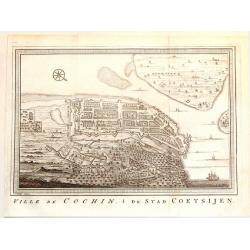
Ville de Cochin de Stad Coestsijen.
Striking copper engraving of Kochi, a major port city on the west coast of India. It has been considered as the center of the Indian spice trade for centuries. It was fir...
Date: Amsterdam, 1755
Selling price: ????
Please login to see price!
Sold in 2018
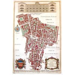
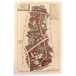
Cripplegate Ward with its Division into Parishes According to a New Survey.
A fine decorative, detailed plan of a section of London, England from John Stow's "A SURVEY OF THE CITIES OF LONDON & WESTMINSTER" published in London in 17...
Date: London, 1755
Selling price: ????
Please login to see price!
Sold in 2018
Aldgate Ward with its Division into Parishes Taken from the Latest Survey.
A fine decorative, detailed plan of a section of London, England from John Stow's "A SURVEY OF THE CITIES OF LONDON & WESTMINSTER" published in London in 17...
Date: London, 1755
Selling price: ????
Please login to see price!
Sold in 2019
A Mapp of Lime Street Ward, Taken from ye Last Surveys & Corrected.
An eighteenth-century plan of Lime Street Ward in the heart of the City of London. The area covered extends north from Fenchurch Street across Leadenhall Street and via S...
Date: London, 1755
Selling price: ????
Please login to see price!
Sold in 2019
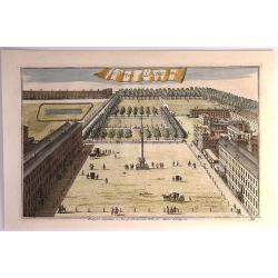
The Prospect of Lincoln's Inn.
A pleasing picture of 'The Prospect of Lincoln's Inn' included in 'Stow's Survey of London', a fine copper engraving published in 1755. It is an fine example of the Engli...
Date: London, 1755
Selling price: ????
Please login to see price!
Sold in 2018
Normannia Galliae Celebris Provincia
A detailed map of the Normandy coast based on the cartography of Delisle. On the left side is a glimpse of the Atlantic Ocean. In the lower right is Chartres. In the uppe...
Date: Nuremberg, 1755
Selling price: ????
Please login to see price!
Sold in 2017
Nouvelle mappe-monde avec la représentation des deux hémisphères ... Gravée par Delamonce et publiée par Daudet, marchand de cartes à Lyon. . .
The much rarer state 2: Now with Mer de L'Ouest and De Fonte's geography ("De Fonte's myth") added to the northwest coast of North America. This is the rare var...
Date: Lyon, 1755
Selling price: ????
Please login to see price!
Sold in 2016
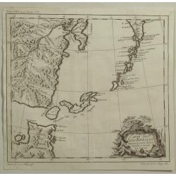
Carte du Kamtchatka.
A striking map of the Kamchatkan peninsula, that provides a detailed view of the topography with mountains, rivers, lakes, roads and settlements carefully noted. Not many...
Date: Paris, 1755
Selling price: ????
Please login to see price!
Sold in 2016
Carte des cotes de l'Hindoustan depuis Bombay jusqu'à Godavery . . .
A well engraved and highly detailed chart that was prepared by M. Daussy. Engraved by Chassant, engraver for the Depot Générale de la marine is noted as such on the map...
Date: Paris, 1755
Selling price: ????
Please login to see price!
Sold in 2016
Partie Occidentale de la Nouvelle France ou de Canada.
An important and influential map of the Great Lakes region during the time of French colonial occupation. This map was originally engraved by Jacques Bellin in 1745, howe...
Date: Nuremberg, 1755
Selling price: ????
Please login to see price!
Sold in 2017
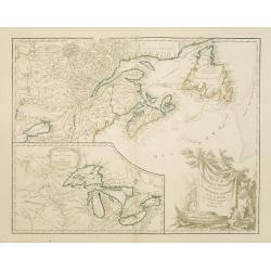
Partie orientale de la Nouvelle France ou du Canada.
This is a finely engraved map which embraces Eastern Canada and Northern New England, and is focused on the River and Gulf of St. Lawrence, then the gateway to French Nor...
Date: Nuremberg, 1755
Selling price: ????
Please login to see price!
Sold in 2018
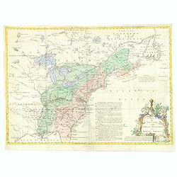
A Map of the British and French Settlements in North America.
An interesting and informative map highlighting (in green) the areas of dispute between England and France and the beginning of the French & Indian War. Explanatory n...
Date: London, 1755
Selling price: ????
Please login to see price!
Sold in 2016
Partie Orientale de la Nouvelle France ou du Canada...
Homann Heirs issue of Bellin's important map of the French explorations in eastern Canada around the River and Gulf of St. Lawrence. Map extends from Newfoundland to Lake...
Date: Nuremberg, 1755
Selling price: ????
Please login to see price!
Sold in 2017
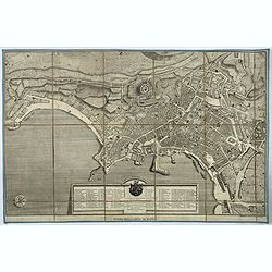
Pianta della citta' di Napoli.
Very rare town-plan of Naples, designed and engraved by the French architect Maurice-Louis Jolivet, and published in Naples by Gravier. It is accompanied by numbered key ...
Date: Naples, ca. 1755
Selling price: ????
Please login to see price!
Sold in 2017
A Map of the British and French Settlements in North America.
This is the first map illustrating the French - British conflict in North America. It was issued just before the French and Indian War was officially. It illustrates by h...
Date: London, 1755
Selling price: ????
Please login to see price!
Sold in 2017
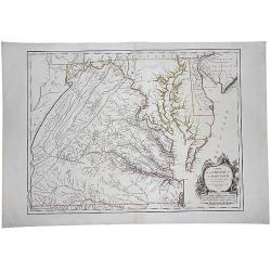
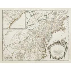
Carte De La Virginie Et Du Maryland Dressee sur la grande carte Angloise de Mrs. Josue Fry et Pierre Jefferson (First State, with Lord Fairfax Line Shown), 1755
A copperplate border-colored map of Virginia and Maryland. A striking example of the single sheet version of the seminal Fry-Jefferson map, engraved by Elisabeth Haussard...
Date: Paris, 1755
Selling price: ????
Please login to see price!
Sold in 2017
Cow Cross, Being St. Sepulcher's Parish with the Charter House.
A lovely detailed copper engraved city plan of Saint Sepulcher's parish featuring the Charter House. The key at the right lists 29 featured locations within the parish. ...
Date: London, 1755
Selling price: ????
Please login to see price!
Sold in 2018
History of China, the Modern History, By Way of Sequel to Mr. Rollin's Ancient History.
A rare book translated from French and printed for J.& P. Knapton. The volume is divided into a number of parts, covering a general history of China; a description of...
Date: London, 1755
Selling price: ????
Please login to see price!
Sold in 2018
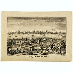
Constantinople.
Decorative engraving by James Mynde (fl.1720-1760) from Thomas Salmon's The Universal Traveller .
Date: London 1755
Selling price: ????
Please login to see price!
Sold in 2020
Mapa Mundi O Description Del Globo Terrestre Compuesta segun las ultimas y nuevas oserationes de las Academias, y de Parsi y de Londres . . .
Very rare and unrecorded double hemisphere map of the World. The map showing Nueva Hollanda (Australia), "Lago Hermoso" or Sea of the West, along with Lago Vela...
Date: London or Spain, ca. 1755
Selling price: ????
Please login to see price!
Sold in 2020
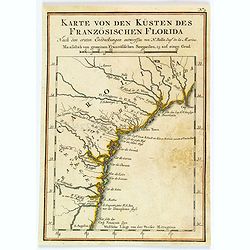
Karte von den Kusten des Franzosischen Florida.
A nice, uncommon map of French Florida, covering South Carolina, Georgia and Florida, from the German edition of Charlevoix's History of New France.The map extent is fro...
Date: Paris, 1744-1755
Selling price: ????
Please login to see price!
Sold in 2019
![Carolinae[,] Floridae nec non Insularum Bahamensium cum partibus adjacendibus delineatio ad Exemplar Londinense in lucem edita a Ioh. Michael Seligmann[,] Norimbergae Ao. 1755](/uploads/cache/82109-250x250.jpg)
Carolinae[,] Floridae nec non Insularum Bahamensium cum partibus adjacendibus delineatio ad Exemplar Londinense in lucem edita a Ioh. Michael Seligmann[,] Norimbergae Ao. 1755
The first and only continental edition of one of the finest and most important maps of southeastern North America – Catesby's Map of Carolina, Florida, and the Bahama I...
Date: Nuremberg, 1755
Selling price: ????
Please login to see price!
Sold in 2020
A Map of the British and French Settlements in North America.
An interesting and informative map highlighting the dispute (the shaded areas) between England and France at the beginning of the French & Indian War. Explanatory not...
Date: London, 1755
Selling price: ????
Please login to see price!
Sold in 2019
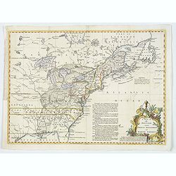
Carte D'Une Partie de L' AMERIQUE SEPTENTRIONALE.
A fine example of this highly detailed set of maps illustrating the British Colonies in North America at the conclusion of the American Revolution, published by Soules in...
Date: Paris, ca 1755
Selling price: ????
Please login to see price!
Sold in 2019
The World, Agreeable to the latest Discoveries.
A twin hemisphere map of the world by English cartographer Thomas Jeffereys, published in London during the mid-eighteenth century. The map shows an incomplete Australia ...
Date: London, ca 1755
Selling price: ????
Please login to see price!
Sold in 2019
Waher Abriss der Stadt Bethlehem. . .
A magnificent panoramic view of the city of Bethlehem described as "true" and "accurate" based on the work of monk of the Strasbourg Province of the F...
Date: Augsburg, 1755
Selling price: ????
Please login to see price!
Sold in 2019
![A NEW CHART of the Vast ATLANTIC OCEAN, Exhibiting The SEAT of WAR, both in EUROPE and AMERICA. [Popple]](/uploads/cache/83196-250x250.jpg)
A NEW CHART of the Vast ATLANTIC OCEAN, Exhibiting The SEAT of WAR, both in EUROPE and AMERICA. [Popple]
A scarce map of the Atlantic with Sailing Routes To New York & Boston. A fine example of Emmanuel Bowen's fascinating broadside map of the Atlantic, which includes a ...
Date: London, 1755
Selling price: ????
Please login to see price!
Sold in 2019
Canada Louisiane et Terres Angloises.
The two northern sheets of a four-sheet map featuring the Great Lakes, the upper Mississippi River and the Atlantic coast region. Large, decorative cartouche designed by ...
Date: Paris, 1755
Selling price: ????
Please login to see price!
Sold in 2020
Partie Occidentale de la NOUVELLE FRANCE ou du CANADA.
A fine large-scale map derived from Bellin's landmark map of the Great Lakes which first appeared in Charlevoix's Histoire in 1744. However, Homann's publication is more ...
Date: Nuremberg, 1755
Selling price: ????
Please login to see price!
Sold in 2020
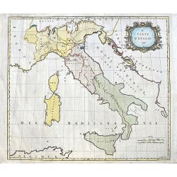
2e. Carte D'Italie 1755.
A curious map of Italy by Thomas Kitchin. Only a few major cities and rivers are named. Also the Vesuv and Etna volcanoes are shown. With a large decorative title cartouc...
Date: London, 1755
Selling price: ????
Please login to see price!
Sold in 2020
![CARTE DE L'AMERIQUE SEPTENTRIONALE, Depuis le 28 Degre...[Sea of the West]](/uploads/cache/85714-250x250.jpg)
CARTE DE L'AMERIQUE SEPTENTRIONALE, Depuis le 28 Degre...[Sea of the West]
A large and rare map that covers nearly all of North America, especially the USA. An important map of North America, with interesting geographical features: * Incorperati...
Date: Paris, 1755
Selling price: ????
Please login to see price!
Sold in 2021
-250x250.JPG)
Gezigt van den Tuin van Somerset's Paleis, Langs den Theems tot op de Brug van Londen
Very nice 18th century copper engraved view of London from the bank of the Thames, with St. Paul´s Cathedral central on the image and showing many interesting details. T...
Date: 1755
Selling price: ????
Please login to see price!
Sold in 2023
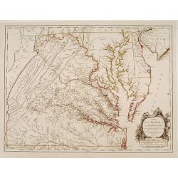
Carte de la Virginie et du Maryland..
A first state (of 5), with "Limites de Lord Fairfax".The late eighteenth century mapping of Virginia was dominated by Joshua Fry and Peter Jefferson's A Map of ...
Date: Paris 1755
Selling price: ????
Please login to see price!
Sold
L' Asie.
This is a map from: Discours sur l' Histoire Universellean encyclopedia published in Amsterdam in 1755 this map is based on Sanson's cartography.
Date: Amsterdam 1755
Selling price: ????
Please login to see price!
Sold
Partie Occidentale de la Nouvelle France ou des Canada.
A fine large-scale map derived from Bellin's landmark map of the Great Lakes which first appeared in Charlevoix's Histoire in 1744. However, Homann's publication is more ...
Date: Nuremberg 1755
Selling price: ????
Please login to see price!
Sold
Partie de l\'Amerique septentrionale.. le cours de L\'Ohio..
From the Atlas Universel , a detailed map extending the length of the east coast from Penobscot Bay to Cape Fear and, in an inset, from Cape Fear to Fort St.Georges. This...
Date: Paris, 1755
Selling price: ????
Please login to see price!
Sold in 2008
Partie de l'Amerique Septent. .
A fine copy of this map of New Foundland, Nova Scotia and the course of the St.Lawrence to Lake Ontario. An inset shows Bellini's famous and important map of the Great La...
Date: Paris, 1755
Selling price: ????
Please login to see price!
Sold in 2014

Carte de la Riviere de la Plata.
Jaques Nicolas Bellin (1702-720) was the most important French hydrographer of the 18th century. Sea-atlas 'Hydrographique Français' , 1756-65, atlas to accompany Prévo...
Date: Paris, c. 1755
Selling price: ????
Please login to see price!
Sold
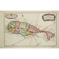
Carte de l?Isle de St. Christofle.
Jaques Nicolas Bellin (1702-720) was the most important French hydrographer of the 18th century. Sea-atlas 'Hydrographique Français' , 1756-65, atlas to accompany Prévo...
Date: Paris, c.1755
Selling price: ????
Please login to see price!
Sold
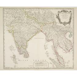
Les Indes Orientales, ou sount distingues les Empires et Royaumes..
Interesting regional map extending from India, the Ganges and the Maldive Islands to Hai-nan, Cochinchina, Malacca and Sumatra. Includes islands, towns, mountains, rivers...
Date: Paris 1755
Selling price: ????
Please login to see price!
Sold
Carte du Kamtchatka.
Jaques Nicolas Bellin (1702-720) was the most important French hydrographer of the 18th century. Sea-atlas 'Hydrographique Français' , 1756-65, atlas to accompany Prévo...
Date: Paris, c. 1755
Selling price: ????
Please login to see price!
Sold in 2016
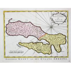
Carte Particulare de l' Isle d' Amboine.
Jaques Nicolas Bellin (1702-720) was the most important French hydrographer of the 18th century. Sea-atlas 'Hydrographique Français' , 1756-65, atlas to accompany Prévo...
Date: Amsterdam, c. 1755
Selling price: ????
Please login to see price!
Sold in 2009