Browse Listings
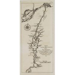
Karte von dem Flube Richelieu und dem See Champlain. . . N°IV.
An important early map of the Champlain River and its lake. In: Allgemeine Historie der Reisen zur Wasser und zu Lande: oder Sammlung aller Reisebeschreibungen.. in Engli...
Date: Leipzig, 1753
Selling price: ????
Please login to see price!
Sold in 2008
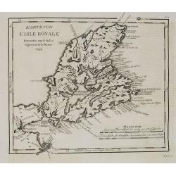
Karte von L'Isle Royale. . . . N°15.
Early map of Cape Breton Island - here called l'Isle Royale. An important island for the French as many strong holds were situated on the island. The most important was L...
Date: Leipzig, 1753
Selling price: ????
Please login to see price!
Sold in 2008
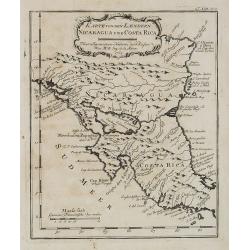
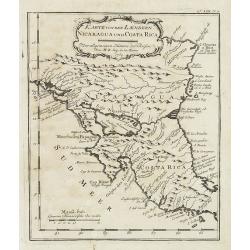
Karte von den Laendern Nicaragua und Coasta Rica. . . . N°18.
An important early map of Nicaragua and Costa Rica. In: Allgemeine Historie der Reisen zur Wasser und zu Lande: oder Sammlung aller Reisebeschreibungen.. in Englischen zu...
Date: Leipzig, 1753
Selling price: ????
Please login to see price!
Sold in 2008
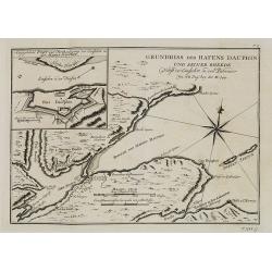
Grundriss des Hafens Dauphin. . . . N°17.
This map details St. Anns Bay on Cape Breton Island. Locates the walled Fort Dauphin (today's Englishtown) on the southern shore.Inset (9x11cm.) of "Angegebenes Fort...
Date: Leipzig, 1753
Selling price: ????
Please login to see price!
Sold in 2008
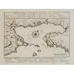
Plan du Port et ville de Louisbourg dans l'Isle Royale. N°XVI.
An important early map of the harbor of Louisbourg in the southeast portion of the island shown in great detail. Large compass rose and fleur-de-lis in the harbor. German...
Date: Leipzig, 1753
Selling price: ????
Please login to see price!
Sold in 2008
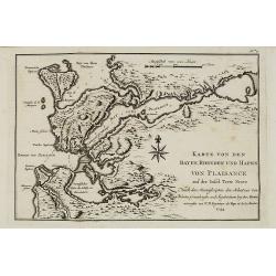
Karte von den Bayen, Rheeden und Hafen von Plaisance aus der Insel Terre Neuve. N°7.
An important early map of the Bay of Placentia on Newfoundland's southern coast with details of the region around the fort, of Placentia Bay (here Bay von Plaisance), the...
Date: Leipzig, 1753
Selling price: ????
Please login to see price!
Sold in 2008
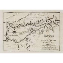
Grundriss von Port Royal in Accadia von den Englaendern Annapolis Royale. N° 12.
An important early map of Port Royal in Accadia. Acadia (in the French language Acadie) was the name given to lands in a portion of the French colonial empire in northeas...
Date: Leipzig, 1753
Selling price: ????
Please login to see price!
Sold in 2009
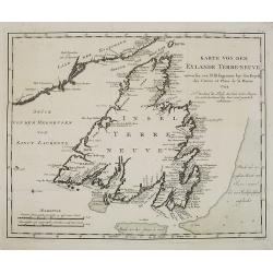
Karte von dem Eylande Terre-Neuve. N°6.
This important early map of the island of Terre-Neuve in Newfoundland shows a part of the mainland on the upper left and includes the Strasse von Bell' Isle and part of t...
Date: Leipzig, 1753
Selling price: ????
Please login to see price!
Sold in 2008
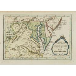
Karte von der Bay Chesapeack und den benachbarten Landen. . .
Uncommon German text edition of Bellin's important and interesting map of the Chesapeake Bay, with excellent detail on New Jersey, Maryland, Virginia, and Pennsylvania. I...
Date: Leipzig, 1753
Selling price: ????
Please login to see price!
Sold
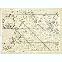
Afteekening van een gedeelte van de kust van Arracam, Pegu en Siam van de rivier Arracam, tot aan de Noordhoek van 't Eyland Sumatra.
Very rare chart of the Andaman Sea and Strait of Malacca. East to the top. In the top the town of Pegu in Myanmar is shown, than the chart follows the coast of Thailand t...
Date: Amsterdam, 1753
Selling price: ????
Please login to see price!
Sold in 2017
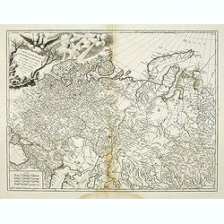
Partie Septentrionale de la Russie Européenne . . .
Map of the northern part of the Russian Empire, north of Moscow, including most of Finland.
Date: Paris, 1753
Selling price: ????
Please login to see price!
Sold in 2009
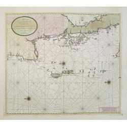
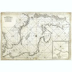
De Reede van 't Leith van Edenburgh. / Afteekening van Nieuw en Oud Aberdeene . . .
Latitude scale, compass rose and system of rhumb lines, soundings, anchorage's, etc. A wealth of cities and information appear in the chart. In upper right corner inset v...
Date: Amsterdam, 1753
Selling price: ????
Please login to see price!
Sold in 2011
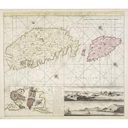
Nieuwe afteekening van de eylanden van Gozo en Melite of Malta met desselfs haven stad kasteelen en sterktens geleegen in de Middelandsche Zee. . .
A finely engraved and detailed chart of Malta and Gozo. With inset of Valetta and lettered key (148x293mm.) In the lower right two panoramic views "Gesigt van t inko...
Date: Amsterdam, 1753
Selling price: ????
Please login to see price!
Sold in 2009
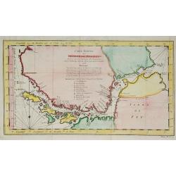
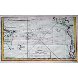
Carte reduite du Détroit de Magellan . . .
A good engraved map of Strait of Magellan. The geographical features are typical with somewhat exaggerated bays and inlets. From l'Histoire générale des voyages.
Date: Paris, 1753
Selling price: ????
Please login to see price!
Sold in 2010
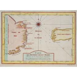
Carte du Détroit de Le Maire . . .
A good engraved map of Strait of Le Maire. From Histoire générale des voyages.
Date: Paris, 1753
Selling price: ????
Please login to see price!
Sold in 2011
Karte von den Laendern Nicaragua und Coasta Rica. . . . N°18.
Early map of Nicaragua and Costa Rica. Published in: Allgemeine Historie der Reisen zur Wasser und zu Lande: oder Sammlung aller Reisebeschreibungen.. in Englischen zusam...
Date: Leipzig, 1753
Selling price: ????
Please login to see price!
Sold in 2011
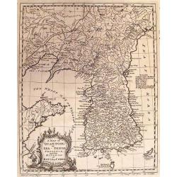
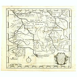
A MAP OF QUAN-TONG OR LEA-TONGE PROVINCE and the KINGDOM OF KAU-LI OR COREA.
Detailed map of Korea, Liaodong, and the tip of Shandong Province prepared by Thomas Kitchin for Thomas Salmon's Universal Traveller, based on D'Anville's landmark map of...
Date: LONDON, 1753
Selling price: ????
Please login to see price!
Sold in 2010
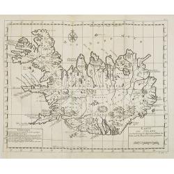
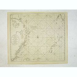
Karte von Island. . . N°1.
Map of Iceland. In: Allgemeine Historie der Reisen zur Wasser und zu Lande: oder Sammlung aller Reisebeschreibungen.. in Englischen zusammen getragen, und aus demselben u...
Date: Leipzig, 1753
Selling price: ????
Please login to see price!
Sold in 2015
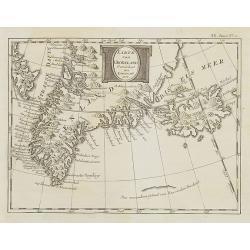
Karte von Groenland gezeichnet von Laurent 1770 . . . XX. Band N°1.
Map of Greenland and Iceland. In: Allgemeine Historie der Reisen zur Wasser und zu Lande: oder Sammlung aller Reisebeschreibungen.. in Englischen zusammen getragen, und a...
Date: Leipzig, 1753
Selling price: ????
Please login to see price!
Sold in 2010
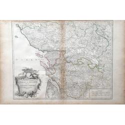
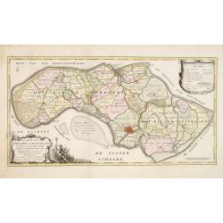
Gouvernemens Generaux du Poitou, du Pays d'Aunis, et de Saintonge-Angoumois
Map of the Poitoi-Charentes region of France, along the central western coast, showing the cities of Rochefort, Poitiers, Niort and Saintes. Ornamental cartouche is in lo...
Date: Paris: 1753
Selling price: ????
Please login to see price!
Sold in 2010
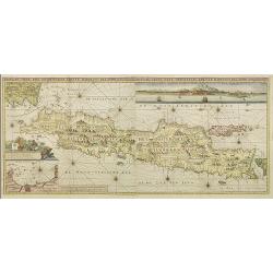
Insulae Java Pars Occidentalis Edente Hadriano Relando. . .
Second state of this finely engraved and detailed chart of Java important for its Dutch trading connections - annotated panels, clearly indicated rice fields, mountains, ...
Date: Amsterdam, 1753
Selling price: ????
Please login to see price!
Sold
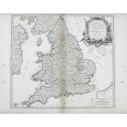
Le Royaume d'Angleterre, divise felon les sept Royaumes, ou Heptarchie des Saxons, avec La Principaute de Galles, et subdivise et Shires ou Comtes
Finely detailed, large scale map of England by Robert de Vaugondy. A large decorative title cartouche is at the top right corner.Gilles Robert de Vaugondy (1688-1766), al...
Date: Paris, 1753
Selling price: ????
Please login to see price!
Sold in 2010
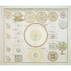
Schematismus Geographiae Mathematicae. . .
A charming print showing a celestial and an armillary globe and circular diagrams illustrating the theories of Copernicus and Brahe. Compass-card, two wall maps of Asia a...
Date: Nuremberg, 1753
Selling price: ????
Please login to see price!
Sold in 2011
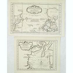
![[2 charts] Kaart van Pulo Condor, of het Eiland Condor.. / Paskaart van de Baay van Padaran op de Kust van Tsiompa..](/uploads/cache/31196-250x250.jpg)
[2 charts] Kaart van Pulo Condor, of het Eiland Condor.. / Paskaart van de Baay van Padaran op de Kust van Tsiompa..
Two finely engraved and detailed charts of Condor Island and the Bay of Pandaran near Vietnam.Latitude scale, compass rose and system of rhumb lines, soundings, anchorage...
Date: Amsterdam, 1753
Selling price: ????
Please login to see price!
Sold in 2011
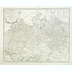
Carte Generale de L'Empire des Russes en Europe et en Asie dressée d'après les cartes de l'Atlas Russien. . .
Detailed map of Russia. extending from Poland and the Black Sea to Nova Zembla and the Jenisseniskoi region. Large decorative cartouche with six wind heads.
Date: Paris, 1753
Selling price: ????
Please login to see price!
Sold in 2011
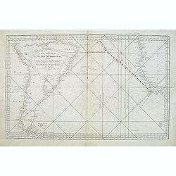
Carte de L'Ocean Oriental ou Mer des Indes..
Detailed map of the Indian Ocean depicting incomplete coastline for Western Australia marked with seven place names, including 'Baye des Chiens Marins veue par Dampierre ...
Date: Paris, 1753
Selling price: ????
Please login to see price!
Sold in 2011
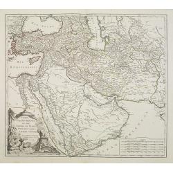
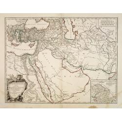
Etats du Grand Seigneur en Asie Pays des Usbecs, Arabie et Egypte. . .
Beautifully engraved map of the Arabian peninsula and Turkey printed by Robert de Vaugondy. Ornamental title cartouche on the lower left corner of two figures one of whic...
Date: Paris, 1753
Selling price: ????
Please login to see price!
Sold
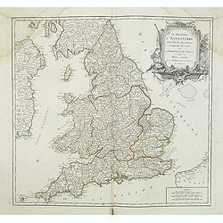
Le Royaume D'Angleterre, divise selon les sept Royaumes ou Heptrachie des Saxons, avec La Principaute De Galles, et subdivisie en Shires ou Comtes...
Decorative map of British Isles with Rococo title cartouche, engraved by E.Haussard.
Date: Paris, 1753
Selling price: ????
Please login to see price!
Sold in 2014
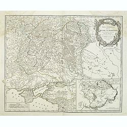
Partie méridionale de la Russie Européenne. . .
Detailed map of Ukraine and the Crimea. In lower right corner inset map of Cosaques. From his "Atlas Universel".Gilles Robert de Vaugondy (1688–1766), also kn...
Date: Paris, 1753
Selling price: ????
Please login to see price!
Sold in 2011
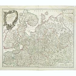
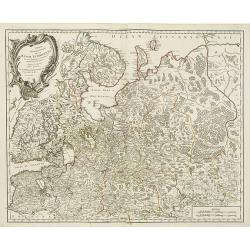
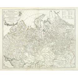
Partie Septentrionale de la Russie Européenne . . .
Detailed map of European part of Russia, including Finland, Lapland from his "Atlas Universel".Address and date in cartouche have been removed. Gilles Robert de...
Date: Paris, ca. 1753
Selling price: ????
Please login to see price!
Sold in 2011
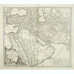
Etats du Grand Seigneur en Asie Pays des Usbecs, Arabie et Egypte. . .
Beautifully engraved map of the Arabian peninsula and Turkey printed by Robert de Vaugondy. Ornamental title cartouche on the lower left corner of two figures one of whic...
Date: Paris, 1753
Selling price: ????
Please login to see price!
Sold in 2011
Partie Occidentale de l'Empire de Russie ou se trouve distinguée la Russie Européenne. . .
Detailed map of the European part of Russia from his "Atlas Universel".Gilles Robert de Vaugondy (1688–1766), also known as Le Sieur or Monsieur Robert, and h...
Date: Paris, 1753
Selling price: ????
Please login to see price!
Sold in 2011
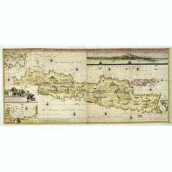
Insulae Java Pars Occidentalis Edente Hadriano Relando. . .
Second state of this finely engraved and detailed chart of Java important for its Dutch trading connections - annotated panels, clearly indicated rice fields, mountains, ...
Date: Amsterdam, ca. 1753
Selling price: ????
Please login to see price!
Sold in 2018
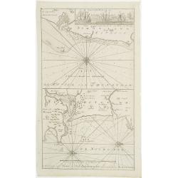
Pas-Kaaart van de Haven van Nangasequi.
A rare and finely engraved and detailed chart of Nagasaki.Latitude scale, compass rose and system of rhumb lines, soundings, anchorage's, etc.Very rare: only included in ...
Date: Amsterdam, 1753
Selling price: ????
Please login to see price!
Sold
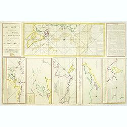
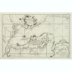
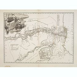
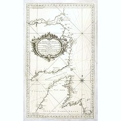
Carte Réduite des Côtes de l'Acadie et de la partie Méridionale de l'Isle de Terre-Neuve
Important chart of Nova Scotia, southern Newfoundland and the Grand Banks, prepared after Chabert's voyage to Canada to update the French charts of Eastern Canada. It sho...
Date: Paris, c. 1753
Selling price: ????
Please login to see price!
Sold in 2012
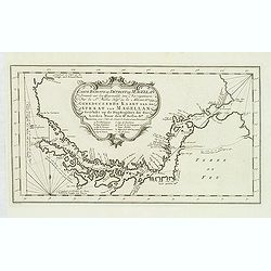
Carte Reduite du Detroit de Magellan. . .
Detailed chart of the Strait of Magellan from Cap des Vierges to Cap de la Victoire. The rococo title cartouche with title in French and Dutch "Gereduceerde Kaart va...
Date: Amsterdam, 1753
Selling price: ????
Please login to see price!
Sold in 2012
Two maps of North American interest.
Lot with two maps : "Zusammen gezogene Karte von den Nordlichen Theilen der Erd-Kugel zwischen Asien und America. . . " (210x340mm.) and "Karte von den Nor...
Date: Leipzig, 1753
Selling price: ????
Please login to see price!
Sold in 2013
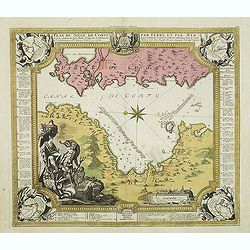
Plan du siege de Corfu par Terre et par Mer.
Uncommon map of the western coast of Corfu, including the town of Kérkira and its siege on July 5th, 1716. Upper part the coast of the Greek province of Sarande. Well-en...
Date: Nuremberg, 1753
Selling price: ????
Please login to see price!
Sold in 2013
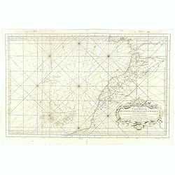
Neue und richtige Karte von dem Stillen Meere oder Mar der Sur . . . Pl.XXXVI.
Coastline map of Mexico starting from Acapulco and also including the Bay de San Francisco, the image oriented with East at the top of the image, which is largely of the ...
Date: Leipzig, 1753
Selling price: ????
Please login to see price!
Sold in 2012
Partie Occidentale de l'Empire de Russie ou se trouve distinguée la Russie Européenne. . .
Detailed map of the European part of Russia, prepared after Russian maps. The map has a rather long title, the first part reading "Partie occidentale de l'empire de ...
Date: Paris, 1753
Selling price: ????
Please login to see price!
Sold in 2016
Carte réduite de l'Océan Méridional: contenant toutes les costes de l'Amérique Méridionale depuis l'Euqater jusqu' au 57 degré de latitude et les costes. . .
Map of Atlantic ocean. Showing the south-east coast of America, the south-west coasts of Africa. In the lower right the sign of the "Depôt de la Marine".Intere...
Date: Paris, 1753
Selling price: ????
Please login to see price!
Sold in 2016
Antiquor Imperiorum tabula, in quâ prae caeteris, Macedonium seu Alexandri. . .
Ancient map showing the Caspian Sea in the north, in the west to show Greece, east to the Indus River, and south to include the Red Sea and the Nile River valley. Almost ...
Date: Paris, 1753
Selling price: ????
Please login to see price!
Sold in 2015
Carte de L'Egypte Ancienne et Moderne. . .
A splendid map of ancient Egypt prepared by R.P.Sicard. From AU 'Préface,' p.31a-b: problem of co-ordinates of Delta: used the observed positions of Alexandra, Peluse, C...
Date: Paris, 1753
Selling price: ????
Please login to see price!
Sold in 2012
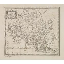
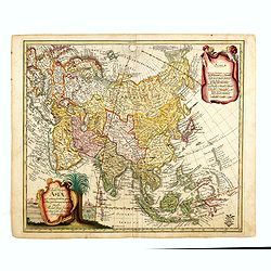
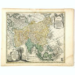
Asia.
Map of Asia from "The universal traveler or a complete description of the several foreign nations of the world" by Richard Baldwin. The work was written by Thom...
Date: London, 1752-1753
Selling price: ????
Please login to see price!
Sold
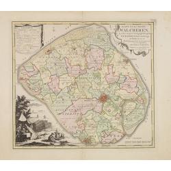
Kaart van het eiland Walcheren..
Detailed map prepared by D.W.Carel and A. Hattinga in 1751. Isaac Tirion was born in Utrecht ca. 1705. He came to Amsterdam ca. 1725. Tirion published a number of importa...
Date: Amsterdam, 1753
Selling price: ????
Please login to see price!
Sold in 2013
Kaarte van Schouwen en Duiveland. . .
Map of Schouwen Duiveland, prepared by D.W. Carel and Anth. Hattinga. Title cartouche accompanied by Neptune. Isaac Tirion was born in Utrecht ca. 1705. He came to Amster...
Date: Amsterdam, 1753
Selling price: ????
Please login to see price!
Sold in 2013
Carte réduite de la Mer du Sud...
Superb map of the South Pacific. The eastern Australia coastline is shown with an imaginary dotted line connecting both Tasmania and New Guinea. New Zealand is shown with...
Date: Paris, 1753
Selling price: ????
Please login to see price!
Sold in 2013
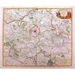
Environs de Paris
Detailed map of Paris and its surroundings with a decorative title cartouche and with cities, towns, forests. lakes, rivers & mountains clearly delineated. Gilles Rob...
Date: Paris, 1753
Selling price: ????
Please login to see price!
Sold in 2014
Asia.
Uncommon miniature map from Gibson's "Atlas Minimus, or a New Set of Pocket Maps of the several Empires, Kingdoms, and States of the known World." John Gibson (...
Date: London, 1752-1753
Selling price: ????
Please login to see price!
Sold in 2013
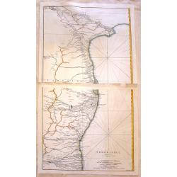
Cormandel.
A large map on two sheets showing the east coast of the Indian peninsula. Covers from Narsapur to Nagapatinam. Includes the cities of Medapili, Kistenapatam, Arimegon, an...
Date: Paris, 1753
Selling price: ????
Please login to see price!
Sold in 2016
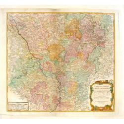
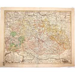
Carte des Cercles du Haut et du Bas Rhin.
Fine engraved hand-colored map of Rhineland Germany. With decorative title cartouche featuring a bishop's hat & miter and king's crown. The River Rhine flows through ...
Date: Paris, 1753
Selling price: ????
Please login to see price!
Sold in 2015
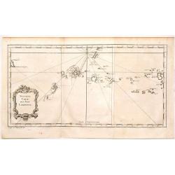
Nouvelle Carte des Isles Carolines.
Antique map of the Caroline Islands, north east of New Guinea and east of the Philipines. Adored with a nice floral, title cartouche. Jacques Nicolas Bellin (1703 – 177...
Date: Paris, 1753
Selling price: ????
Please login to see price!
Sold in 2015
Tabula Geographica Circ. Saconiae Superioris et Inferioris.
Fine map featuring Poland and Saxony Germany. From the atlas "Atlas Geographicus Omnes Orbis Terrarum Regiones in XLI Tabulis".CARTOGRAPHER: Leonhard Euler (170...
Date: Berlin, 1753
Selling price: ????
Please login to see price!
Sold in 2015
Tab. Geogr. Circ. Franconiae dimid Saxoniae Superioris.
Fine map featuring part of Poland, Germany and the Czech Republic. From the atlas "Atlas Geographicus Omnes Orbis Terrarum Regiones in XLI Tabulis".CARTOGRAPHER...
Date: Berlin, 1753
Selling price: ????
Please login to see price!
Sold in 2015
Tab: Georg : Asiae ad emendatiora quae ad huc prodierunt exempla jussu Acad. Reg. Scient. et eleg. Litt. Pruss. descripta.
Detailed and scarce map of Asia, published in "Geographischer Atlas bestehend in 44 Land-Charten, worauf alle Theile des Erd-Creyses vorgestellet werden" and ma...
Date: Berlin, 1753
Selling price: ????
Please login to see price!
Sold in 2023
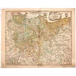
Carte de la Mer Baltique contenant les bancs, isles et costes comprises entre l'isle de Zelande et l'extrémité du Golfe de Finlande.
Important chart of the Baltic Sea with the coasts of Sweden, Finland, Russia, Estonia, Lettland, Lithuania and Poland. With many place names along the coasts, anchor plac...
Date: Versailles, 1753
Selling price: ????
Please login to see price!
Sold in 2014
Carte réduite des Terres Australes : pour servir a l'Histoire des voyages. . . 1753.
A nice and decorative map of Australia. Van Diemenland still joined to the main island, prepared by J.N.Bellin. Part of the coastline of New Zealand appears bottom right....
Date: London, 1753
Selling price: ????
Please login to see price!
Sold in 2014
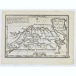
A map of some Provinces in Siberia, and the Borders toward China. . .
Detailed map of Siberia engraved by John Gibson for "The Gentleman's Magazine", founded by visionary Edward Cave, was the world's first monthly general interest...
Date: London, 1753
Selling price: ????
Please login to see price!
Sold in 2014
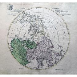
Tabula Geographica Hemisphaerii Borealis...
Uncommon map of the North Pole. Shows the fictitious Mer de L’Ouest prominently with an extensive river system connecting it with the Great Lakes. Alaska is shown parti...
Date: Berlin, 1753
Selling price: ????
Please login to see price!
Sold in 2014
Carte Réduite, Des Côtes De L' Acadie, De L' Isle Royale...
Important sea chart of Nova Scotia, southern Newfoundland and the Grand Banks, prepared after Chabert's voyage to Canada to update the French charts of Eastern Canada. A ...
Date: Paris, ca. 1753
Selling price: ????
Please login to see price!
Sold in 2014
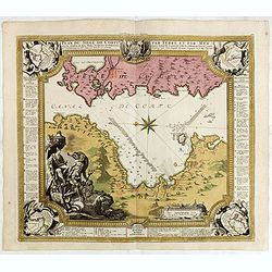
Plan du siege de Corfu par Terre et par Mer.
Uncommon map of the western coast of Corfu, including the town of Kérkira and its siege on July 5th, 1716. Upper part the coast of the Greek province of Sarande. Well-en...
Date: Nuremberg, 1753
Selling price: ????
Please login to see price!
Sold in 2021
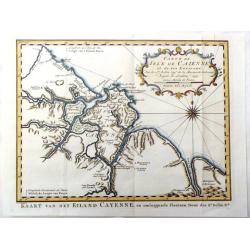
Carte de Isle de Caienne et ses Environs.
Attractive map of the coast of French Guyana on the western coast of South America. Decorated by a fine title cartouche and compass rose.From Raynal's "Histoire Phil...
Date: Paris, 1753
Selling price: ????
Please login to see price!
Sold in 2016
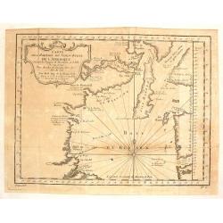
carte des Parties du Nord-Puest de L'Amerique
A fine map featuring northern Hudson Bay in northern Ontario in Canada. Large and decorative title cartouche. The map is from Prevost's "HISTORY OF VOYAGES" de...
Date: Paris, 1753
Selling price: ????
Please login to see price!
Sold in 2017
Tab: Georg : Asiae ad emendatiora quae ad huc prodierunt exempla jussu Acad. Reg. Scient. et eleg. Litt. Pruss. descripta.
Detailed and scarce map of Asia, published in "Geographischer Atlas bestehend in 44 Land-Charten, worauf alle Theile des Erd-Creyses vorgestellet werden" and ma...
Date: Berlin, 1753
Selling price: ????
Please login to see price!
Sold in 2016
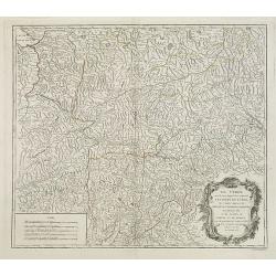
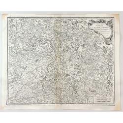
Le Tyrol sous le nom duquel. . .
De Vaugondy's large map of the mountainous Tirol region spanning portios of northern Italy, eastern Switzerland, and western Austria from his "Atlas Universel"....
Date: Paris 1753
Selling price: ????
Please login to see price!
Sold in 2016
Carte Reduite Des Costes Occidentales D'Afrique Premiere Feuille contenant Les Costes de Barbarie depuis le Detroit de Gibraltar jusqu'au Cap Bojador Et Les Canaries . . . MDCCLIII
A well engraved and highly detailed of the Canary Islands, Madeira, from the Straits of Gibraltar to Cap Bojador, and the coast of Morocco. Prepared by Nicolas Bellin. T...
Date: Paris, 1753
Selling price: ????
Please login to see price!
Sold in 2017
Suite de la carte réduite du Golphe de St Laurent contenant les costes de Labrador . . . le détroit de Belle-Isle et partie des cotes de l'Isle de Terre neuv
Sea , prepared and published by Nicolas Bellin. Relief shown by hachures. Depths shown by soundings.
Date: Paris, 1753
Selling price: ????
Please login to see price!
Sold in 2016
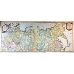
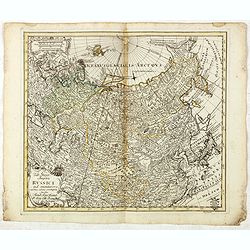
Carte Generale de L'empire des Russes en Europe et en Asie, Dressee D'apres les Cartes de L'Atlas Russien, Par le S. Robert de Vaugondy ....
An extensive map of the Russian Empire by Vaugondy, dated 1753. It stretches across the full extent of Russia from Finland to Kamchatka.There is a stunning title cartouch...
Date: Paris, 1753
Selling price: ????
Please login to see price!
Sold in 2015
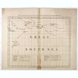
Chart containing the greater part of the South Sea to the south of the line with the islands dispersed thro' the same.
Map has extensive notes and charts noting variations in latitudes and longitudes noted by different observations. Tracks of the ships in the oceans shown along with relev...
Date: London, 1753
Selling price: ????
Please login to see price!
Sold in 2015
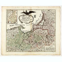
Tabula Geographica Borussiae ad emendatiora adhuc edita exempla iussu Acad. Regiae Scient. et eleg. Litt. Borussicae descripta.
Interesting map of Poland with a decorative title cartouche, and a Prussian duty stamp in the higher cartouche as usually for the Euler maps.Engraved by Nikolaus Friedric...
Date: Berlin, Michaelis, 1753
Selling price: ????
Please login to see price!
Sold in 2015
Tab: Georg : Imperu Russici...
A fine original antique map of Russia, China, Japan and Korea, with a decorative title cartouche, and a Prussian duty stamp at lower right as usually for the Euler maps.T...
Date: Berlin, 1753
Selling price: ????
Please login to see price!
Sold in 2016
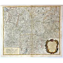
Le Tyrol Sous le Nom Duquel L'On Comprend le Comte de Tyrol
A scarce map of the county of Tyrol in modern day Italy and Austria, It covers this historic region from Lake Constance east to Lienz, Austria, and south as far as Lake G...
Date: Paris, 1753
Selling price: ????
Please login to see price!
Sold in 2016
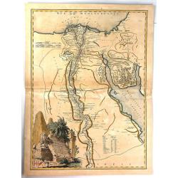
Carte de L'Egypte Ancienne et Moderne.
A fine large map of the Nile River valley with superb detail of cities, towns, villages, canals, pyramids, mosques, ruins and more. Across the Red Sea are details of wher...
Date: Paris, 1753
Selling price: ????
Please login to see price!
Sold in 2018
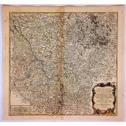
Gouvernemens Generaux de la Marche, du Limousin et de L'Auvergne.
A fine 1753 map of the Limousin, Marche and Auvergne regions of France by Robert de Vaugondy, dated 1753.It features from La Chatre south to Domme and from Perigueux east...
Date: Paris, 1753
Selling price: ????
Please login to see price!
Sold in 2017
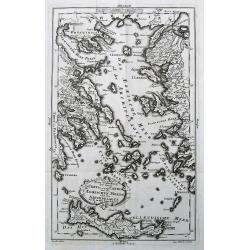
Neue Vorstellung der Insel Creta. . .
A rare map of the Aegean Sea and its islands. From Chalkidiki until Crete. With parts of the Greek and Turkish coats.After Anville, engraved by Reinhardt, published by th...
Date: Frankfurt & Leipzig, 1753
Selling price: ????
Please login to see price!
Sold in 2017
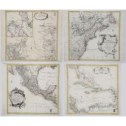
AMERICAE SEPTENTRIONALIS ad emendatiora Exemplaria adhuc edita jussu Aca. Reg. Scjent et. Pars I to IV.
Complete set of Euler's four-part map of North America, published in response to the maps of Mitchell and D'Anville. Part I covers the region from the Mississippi River ...
Date: Berlin, 1753
Selling price: ????
Please login to see price!
Sold in 2017
![Zuverlässige Nachrichten von Island [with] Landkarte von Island.](/uploads/cache/39895-250x250.jpg)
Zuverlässige Nachrichten von Island [with] Landkarte von Island.
>First German edition entitled "Zuverlässige Nachrichten von Island...", translation of Danish book from the previous year. Published in Copenhagen and Leip...
Date: Copenhagen and Leipzig, 1753
Selling price: ????
Please login to see price!
Sold in 2017
Carte des Cercles du Haut et du Bas Rhin...
An attractive detailed map of the Upper Rhine and Lower Rhine regions in western Germany. This area, known as Rhineland-Palatinate, it covers from Saarbrucken north to Pa...
Date: Paris, 1753
Selling price: ????
Please login to see price!
Sold in 2017
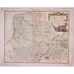
Gouvernment General de Picardie et Artois...
A beautiful de Vaugondy map of Picardy and Artois. The map covers part of the regions of Normandy (Normandie), l'Ile de France (Isle de France), and Champagne.The Pas de ...
Date: Paris, 1753
Selling price: ????
Please login to see price!
Sold in 2023
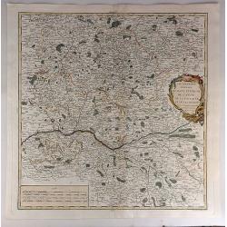
Gouvernemens Generaux du Maine et Perche de L'anjou, de la Touraine et du Saumurois.
This is a fine 1753 map of the French winemaking regions of Maine, Perche, Touraine, Anjou and Saumur. It depicts the whole or parts of the modern day departments of May...
Date: Paris, 1753
Selling price: ????
Please login to see price!
Sold in 2021