Browse Listings
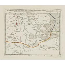
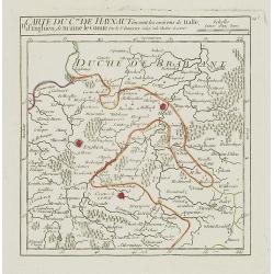
VI. Carte du Brabant ou se trouv.t les envir.s d'Eyndhoven..
Nice small map illustrating part of southeastern Noord Brabant. With Eindhoven and Helmond in center of map.From Atlas Portatif Universel, by Robert de Vaugondy. Unrecord...
Date: Paris, later than 1748
Selling price: ????
Please login to see price!
Sold
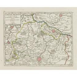
VII. Carte du Brabant ou sont les environs de Bruxelles, de Malines et Liere.
Nice small map illustrating part of the Flemish region and the Brussels-Capital Region. It shows Brussels, Aalst, Dendermonde, Mechelen and Lier.From Atlas Portatif Unive...
Date: Paris, later than 1748
Selling price: ????
Please login to see price!
Sold
![[VIII.] Carte du Brabant ou sont les env.s de Louvain, d'Ascot, de Diest de Leeuwe &c.](/uploads/cache/24688-250x250.jpg)
[VIII.] Carte du Brabant ou sont les env.s de Louvain, d'Ascot, de Diest de Leeuwe &c.
Nice small map illustrating part of the Flemish region. It shows Leuven, Aarschot, Diest and Sint-Truiden.From Atlas Portatif Universel, by Robert de Vaugondy. Unrecorded...
Date: Paris, later than 1748
Selling price: ????
Please login to see price!
Sold in 2022
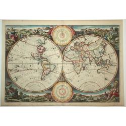
Untitled Worldmap Orbis terrarum
Lovely double hemisphere from a Dutch Bible published by the Keur family. The map is surrounded by allegorical representations of the continents based on Visscher. The Ke...
Date: Amsterdam, 1748
Selling price: ????
Please login to see price!
Sold in 2008
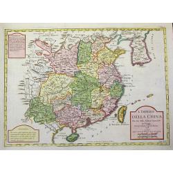
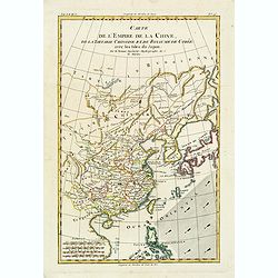
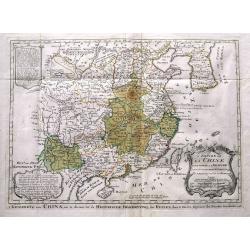
L'Impero della China Per uso della Storia generale de'Viaggi.
Rare uncommon Italian variant of Bellin's three-cartouche map of China. This map shows locations of ethnic groups and communities in China, Korea, and Mongolia. The map s...
Date: Paris, 1748
Selling price: ????
Please login to see price!
Sold in 2008
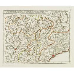
![[III]. Carte de l'Etât de Gênes où se trouvent la Principauté d'Oneille, les enviros d'Albinga, le Marquisat de Finale &c.](/uploads/cache/24546-250x250.jpg)
[III]. Carte de l'Etât de Gênes où se trouvent la Principauté d'Oneille, les enviros d'Albinga, le Marquisat de Finale &c.
Detailed small map showing the Ligurian seacoast stretching from Oneglia as far as Vado Ligure.Relief shown pictorially. From Atlas Portatif Universel, by Robert de Vaugo...
Date: Paris, later than 1748
Selling price: ????
Please login to see price!
Sold in 2013
IV. Carte de l'Etât de Gênes ou se trouvent les environs de Savone..
Detailed small map showing an area straddling the Piedmontese province of Cuneo and the Ligurian province of Savona.Relief shown pictorially. From Atlas Portatif Universe...
Date: Paris, later than 1748
Selling price: ????
Please login to see price!
Sold in 2013
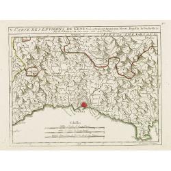
V. Carte des Environs de Genes..
Detailed small map centered on Genoa. With Portofino in the lower right corner. Relief shown pictorially.From Atlas Portatif Universel, by Robert de Vaugondy.Page 56.e ou...
Date: Paris, later than 1748
Selling price: ????
Please login to see price!
Sold in 2017
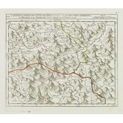
VII. Carte des Confins de l'Etât de Gênes.. Milanez et du Parmesan.
Detailed small map showing an area straddling the provinces of Alessandria, Pavia and Piacenza on 3 different regions.Relief shown pictorially. From Atlas Portatif Univer...
Date: Paris, later than 1748
Selling price: ????
Please login to see price!
Sold in 2014
IX. Carte de l'Etât de Gênes ou se trouvent Sestri-di Levante, Spetia et Sarzana.
Detailed small map showing the east most tip of Liguria. Relief shown pictorially.From Atlas Portatif Universel, by Robert de Vaugondy.Page 56.i outside border top right....
Date: Paris, later than 1748
Selling price: ????
Please login to see price!
Sold in 2008
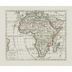
L'Afrique Divisée en ses principales Parties.
Small detailed map of the African continent. Dated 1748. From Atlas Portatif Universel, by Robert de Vaugondy. 75 outside border top right. Mary Sponberg Pedley does not ...
Date: Paris, later than 1748
Selling price: ????
Please login to see price!
Sold in 2013
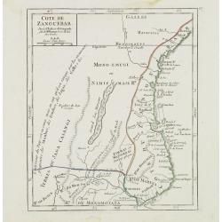
Cote de Zanguebar. . .
Nice small map showing a long stretch of the central Africa east coast. From Atlas Portatif Universel, by Robert de Vaugondy.Page 83 outside border top right. Mary Sponbe...
Date: Paris, later than 1748
Selling price: ????
Please login to see price!
Sold in 2014
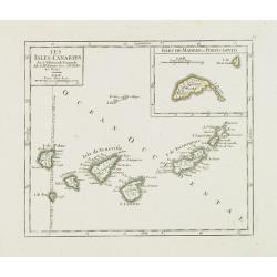
Les Isles Canaries. / Isles de Madere et Porto-Santo.
Charming small map of the Canary Islands. With an inset map of the Madeira Islands in the upper right corner. "Premier Meridien fixe à l'Isle de Fer par la Declarat...
Date: Paris, later than 1748
Selling price: ????
Please login to see price!
Sold in 2012
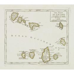
Les Isles du Cap-Verd. . .
Charming small map of the archipelago of Cape Verde. From Atlas Portatif Universel, by Robert de Vaugondy.From Atlas Portatif Universel, by Robert de Vaugondy.Page 87 out...
Date: Paris, later than 1748
Selling price: ????
Please login to see price!
Sold in 2011
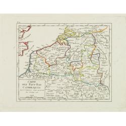
Carte des Pays-Bas Catholiques.
Nice small map that extends from Dieppe to Verdun and north into Holland. Dated 1748.From Atlas Portatif Universel, by Robert de Vaugondy.
Date: Paris, 1748
Selling price: ????
Please login to see price!
Sold in 2008
I. Carte du Comté de Flandre où sont les env.s de l'Ecluse, d'Ardenburg.. &c.
Nice small map illustrating the southwestern most part of Zeeland. Centered on Sluis. Showing Aardenburg and Vlissingen. Dated 1768.From Atlas Portatif Universel, by Robe...
Date: Paris, later than 1748
Selling price: ????
Please login to see price!
Sold in 2008
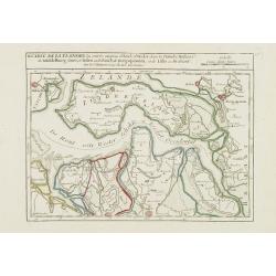
II. Carte de la Flandre où sont les environs d'Axel, d'Hulst..
Nice small map illustrating the southeastern part of Zeeland. Showing Middelburg, Goes, Tholen, Bergen op Zoom, Hulst and Axel.From Atlas Portatif Universel, by Robert de...
Date: Paris, later than 1748
Selling price: ????
Please login to see price!
Sold in 2008
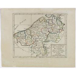
IV. Carte du Comté de Flandre où sont les environs de Bruges, d'Ostende, de Dixmunde.
Nice small map covering part of the West Flanders, delimited by Oostende, Bruges, Tielt, Roeselare and Diksmuide.From Atlas Portatif Universel, by Robert de Vaugondy. Unr...
Date: Paris, later than 1748
Selling price: ????
Please login to see price!
Sold in 2008
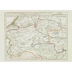
V. Carte de la Flandre où sont les environs de Gand.. et d'Anvers.
Charming small map covering part of the East Flanders, delimited by Ghent, Sas van Gent, Aalst, and Antwerp.From Atlas Portatif Universel, by Robert de Vaugondy. Unrecord...
Date: Paris, later than 1748
Selling price: ????
Please login to see price!
Sold in 2008
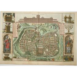
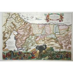
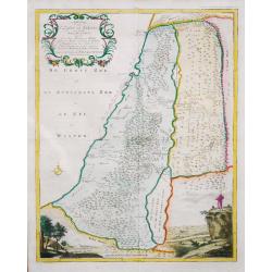
Jerusalem
Great bird's eye plan of the holy city flanked by engravings of religious icons, and Solomon and a priest. At the top is a large elevation of the Temple of Solomon.
Date: Amsterdam, 1748
Selling price: ????
Please login to see price!
Sold in 2008
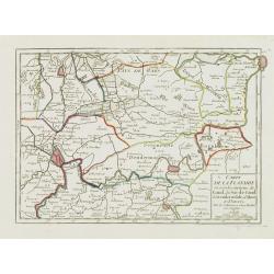
II. Carte du C.té de Haynaut où sont les environs de Halle, d'Enghien, de Braine le Comte.
Attractive small map encompassing part of Hainaut. It shows the towns of Enghien, Halle and Braine-le-Comte.From Atlas Portatif Universel, by Robert de Vaugondy.Unrecorde...
Date: Paris, after 1748
Selling price: ????
Please login to see price!
Sold in 2015
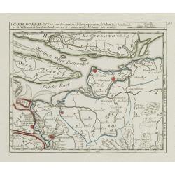
I. Carte du Brabant où sont les environs de Berg-op-zoom, de Tolen dans la Zélande. et de Willemstat dans la Hollande.
Nice small map centered on the western part of North Brabant. It shows Bergen op Zoom, Tholen, Willemstad, Klundert, etc.From Atlas Portatif Universel, by Robert de Vaugo...
Date: Paris, later than 1748
Selling price: ????
Please login to see price!
Sold in 2012
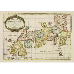
Carte de L'Empire du Japon.
A fine map of the islands of Japan embellished with fine baroque decorations.Bellin influenced other cartographers with his erroneous portrayals of Japan. This is seen in...
Date: Paris, 1748
Selling price: ????
Please login to see price!
Sold
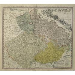
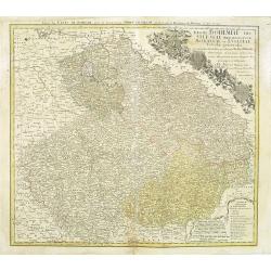
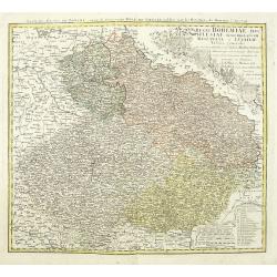
Regni Bohemiae, Duc. Silesiae, Marchionatuum Moraviae et Lusatiae. . .
Johann Baptist Homann's well-engraved map including the towns of Prague, Poznan/ Loda, Wroclaw, etc.Johann Baptist Homann (1663-1724) was a German engraver and publisher,...
Date: Nuremberg, 1748
Selling price: ????
Please login to see price!
Sold in 2013
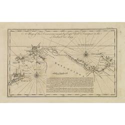
A map of the discoveries made by Captn. Willm. Dampier in the Roebuck in 1699.
This map is of the islands of Timor, New Britain and New Guinea. It appeared in the first volume of John Harris' 'Navigantium atque Itinerantium Bibliotheca. Or, a Comple...
Date: London, T. Woodward, 1744-1748
Selling price: ????
Please login to see price!
Sold in 2011
Pergrinatie ofte Veertich-iarige Reyse
Dutch Bible map of the Holy Land depicting the Exodus from Egypt and the wanderings of the Children of Israel. The lower part of the map is elaborately engraved with a sc...
Date: Amsterdam, 1741/1748
Selling price: ????
Please login to see price!
Sold in 2009
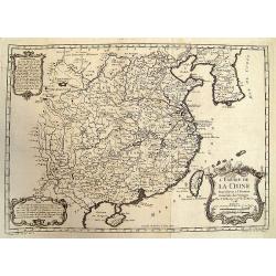
L'Empire de la Chine.
Beautiful example of Bellin's classic map of China with information provided in three delicately engraved cartouches.
Date: Paris, 1748
Selling price: ????
Please login to see price!
Sold in 2009
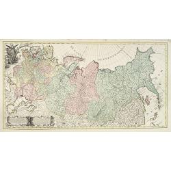
Carte générale de l'empire de Russie.
According to the description panel in lower left : the map covers the Empire of Peter the Great.This important is based on maps from the Bering expedition and on De L'Isl...
Date: Amsterdam, ca.1748
Selling price: ????
Please login to see price!
Sold in 2009
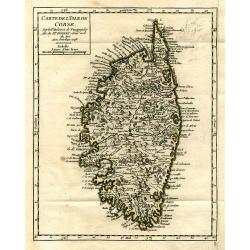
Carte de l'Isle de Corse.
Charming and very detailed map of Corsica. Shows towns, rivers, lakes, woods, mountains, bays, and islands.
Date: Paris, 1748
Selling price: ????
Please login to see price!
Sold in 2010
Regni Bohemiae, Duc. Silesiae, Marchionatuum Moraviae et Lusatiae. . .
Johann Baptist Homann's well-engraved map including the towns of Prague, Poznan/ Loda, Wroclaw, etc.Johann Baptist Homann (1663-1724) was a German engraver and publisher,...
Date: Nuremberg, 1748
Selling price: ????
Please login to see price!
Sold in 2010
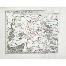
Carte du Duche de Luxembourg ou sont les Seign de Lompre, IV Mirwart et Villance, Partied u Duche de Bouillon, et les Consins du Lyegeois
Small scale map of region of the Duchy of Luxembourg, a former principality of the Holy Roman Empire, showing the region of southern Belgium by Robert de Vaugondy. Gilles...
Date: Paris, 1748
Selling price: ????
Please login to see price!
Sold in 2010
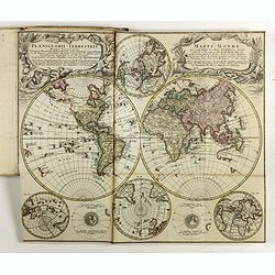
![[Title page] Atlas Portatif, Universel.](/uploads/cache/24701-250x250.jpg)
[Title page] Atlas Portatif, Universel.
Frontispiece from Robert de Vaugondy's "Atlas Portatif, Universel. Composé d'après les meilleures Cartes, tant gravées que manuscrites des plus célèbres Géogra...
Date: Paris, later than 1748
Selling price: ????
Please login to see price!
Sold in 2011
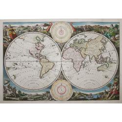
Untitled (World)
Beautiful double hemisphere from a Dutch Bible published by the Keur family. The map is surrounded by allegorical representations of the continents, based on Visscher. Th...
Date: Amsterdam, 1748
Selling price: ????
Please login to see price!
Sold in 2011
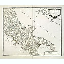
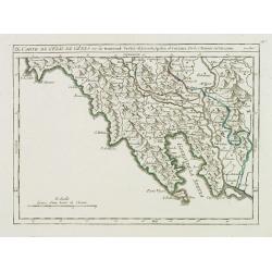
Partie septentrionale du Royaume de Naples.
Map of the southern part of Italy with Naples from his "Atlas Universel".Gilles Robert de Vaugondy (1688–1766), also known as Le Sieur or Monsieur Robert, and...
Date: Paris, 1748
Selling price: ????
Please login to see price!
Sold
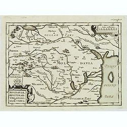
Moldaviae, finitimar umo regionum typus.
Uncommon map of Moldavia published in the second edition of Martinus Broniovius "Tartariae description ..." His work appeared first in 1595. The second edition ...
Date: Vienna, 1746-1748
Selling price: ????
Please login to see price!
Sold in 2012
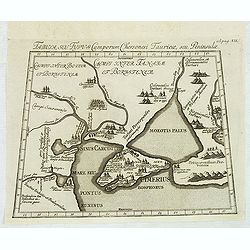
Tabula, seu Typus Camporum Chersonesi . . .
Rare map of part of the Ukraine and the Black Sea region, published in the second edition of Martinus Broniovius "Tartariae description ..."
Date: Vienna, 1746-1748
Selling price: ????
Please login to see price!
Sold in 2012
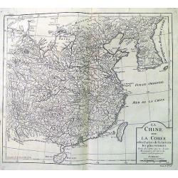
La Chine avec La Coree. . .
Fine map of China, Korea and Taiwan (named as Tayouan ou Formose I.). Prepared after Jesuit sources from 1708-1717.The map is of interest for the use of "Kao-Liqoue ...
Date: Paris, 1748
Selling price: ????
Please login to see price!
Sold in 2012
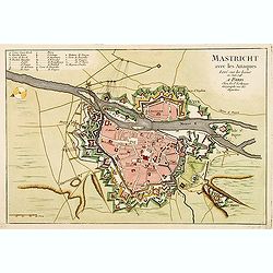
Mastricht avec les Attaques Leve sur les Lieux en Juin 1748. A Paris chez Le Sr. Le Rouge.
A rare separate published plan of Maastricht by G. L. le Rouge. Showing the fortified city with important buildings named. With a key from A to X, a mileage scale and a c...
Date: Paris, 1748
Selling price: ????
Please login to see price!
Sold
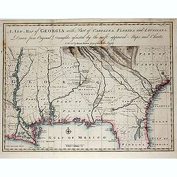
A New Map of Georgia with Part of Carolina, Florida and Loisiana. . .
Scarce and important early map of colonial Georgia. The map covers from Charles Town to the Mississippi River and extends into Florida to C. Canaveral. The coastal settle...
Date: London c.1748
Selling price: ????
Please login to see price!
Sold in 2014
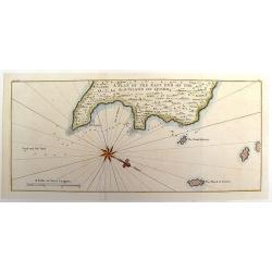
A Plan of the East End of the Island of Quibo.
A map showing the shoreline around Port de Dames indicating soft sand and mud, salt lagoons, fresh water, and fisherman's huts. Also marked are the islands of Quiveta and...
Date: London, 1748
Selling price: ????
Please login to see price!
Sold in 2015
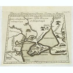
Tabula, seu Typus Camporum Chersonesi Tauricae, seu Peninsulae.
Rare map of part of the Ukraine and the Black Sea region, published in the second edition of Martinus Broniovius "Tartariae description ..." His work appeared f...
Date: Vienna, 1746-1748
Selling price: ????
Please login to see price!
Sold in 2013
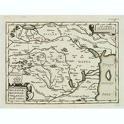
Moldaviae, finitimar umo regionum typus.
Uncommon map of Moldavia published in the second edition of Martinus Broniovius "Tartariae description ..." His work appeared first in 1595. The second edition ...
Date: Vienna, 1746-1748
Selling price: ????
Please login to see price!
Sold
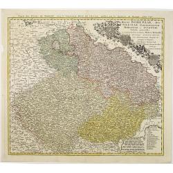
Partie Meridionale du Cercle de Haute Saxe.
Large detailed copper engraved map of the Duchies of Saxe & Meissen in Germany. Features cities such as Prague, Leipzig, Dresden, Berlin & Wittenberg.Johann Bapti...
Date: Nuremberg, 1748
Selling price: ????
Please login to see price!
Sold in 2013

Sir Richard Steele.
This ia a large finely engraved portrait of Sir Richard Steele, the private secretary to James. the 1st Duke of Ormonde. It was engraved by Houbraken from a painting by K...
Date: Amsterdam, 1748
Selling price: ????
Please login to see price!
Sold in 2016
Carte L'Empire de la Chine, de la Tartarie Chinoise..
A fine map of China, Korea, Japan and Taiwan, prepared by R.Bonne and included in his Atlas Ecyclopédique.. Rigobert Bonne (1727-1795) was engineer, mathematician and ca...
Date: Paris, 1748
Selling price: ????
Please login to see price!
Sold in 2013
Regni Bohemiae, Duc. Silesiae, Marchionatuum Moraviae et Lusatiae. . .
Johann Baptist Homann's well-engraved map including the towns of Prague, Poznan/ Loda, Wroclaw, etc.This example was printed from plate B (2nd of 3), which can be identif...
Date: Nuremberg, 1748
Selling price: ????
Please login to see price!
Sold in 2018
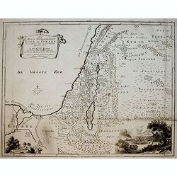
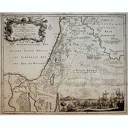
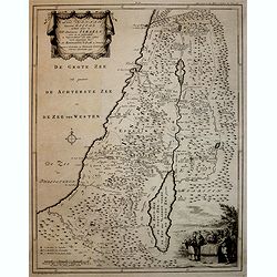
Afbeelding van ' T Land van Israel, naar deszelfs Natuurlijke gesteltheid.
Willem Albert Bachiene (1712-1783), Dutch geographer in Maastricht. Most important work ' Heilige Geographie', a work on the Holy Land.A map of Israel, embellished with t...
Date: Gorichem, Nicolaas Goetzee, 1748
Selling price: ????
Please login to see price!
Sold in 2020
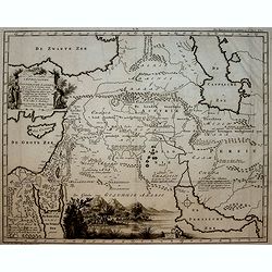
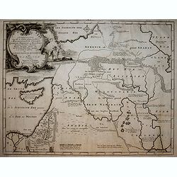
Afbeelding van all de Landen gelegen tusschen de Middellandsche, Zwarte, Caspische, Persische en Rode Zeeën.
A map of the Near East. From a Dutch bible published by Nicolaas Goetzee. Prepared by Willem Albert Bachiene (1712-1783), Dutch geographer in Maastricht. Most important w...
Date: Gorichem, Nicolaas Goetzee, 1748
Selling price: ????
Please login to see price!
Sold in 2020
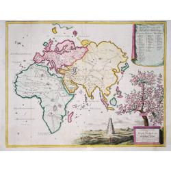
Afbeeldinge der Oude Waereld benevens Derzelve verdeling onder de Nakomelingen Noachs. 1749.
Willem Albert Bachiene (1712-1783), Dutch geographer in Maastricht. Most important work ' Heilige Geographie', a work on the Holy Land.A map of the World as it was known ...
Date: Gorichem, Nicolaas Goetzee, 1748
Selling price: ????
Please login to see price!
Sold in 2017
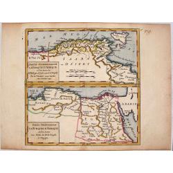
Partie Occidentale (Orientale) de la Turquie D'Afrique.
Two detailed maps on one sheet, featuring the Barbary Coast region of the North African seacoast. It is from "ATLAS PORTATIF UNIVERSAL" by Robert de Vaugondy.
Date: Paris, 1748
Selling price: ????
Please login to see price!
Sold in 2014
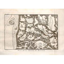
Plan de la Grotte de Kungur.
Interesting map of the Kungeron fortress in Krai Russia in the Ural Mountains. This is the site of the Kungur ice cave.Published in Prevost's "L'Histoire Generale de...
Date: The Hague, 1748
Selling price: ????
Please login to see price!
Sold in 2016
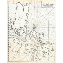
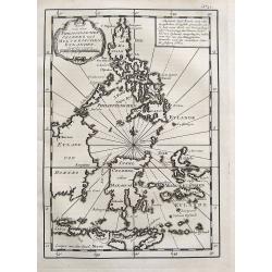
Carte du Canal des Iles Philippines par lequel Passe le Galion de Manille...
This large and detailed copper-engraved sea-chart, is one of the best obtainable maps of the Islands of the Philippines from the 18th century. It provides excellent detai...
Date: Paris, ca. 1748
Selling price: ????
Please login to see price!
Sold in 2016
L' Empire de La Chine...
Detailed map of China and South Korea, with parts Mongolia, Tartar regions, and also showing Hainan and Formosa (Taiwan). With numerous cities shown: Canton, Macao, Pekin...
Date: Paris, ca. 1748
Selling price: ????
Please login to see price!
Sold in 2015

Title Page - Atlas Portatif Universel
A quaint little Title Page from Vaugondy's "ATLAS PORTATIF UNIVERSEL", Published by Bureau de L'atlas National in Paris in 1748.Gilles Robert de Vaugondy (1688�...
Date: Paris, 1748
Selling price: ????
Please login to see price!
Sold in 2018
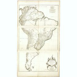
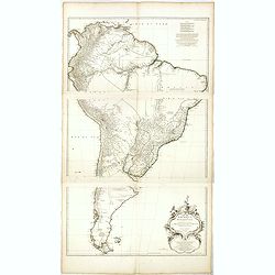
Amérique Meridionale..
Uncommon map of South America in 3 sheets.
Date: Paris, 1748
Selling price: ????
Please login to see price!
Sold in 2016
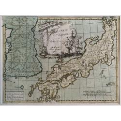
Carte du Japon et de la Korea.
Le Rouge's map of Japan follows the type established by D'Anville with the disproportionately large Korean Peninsula.The large title cartouche features three Japanese god...
Date: Paris, 1748
Selling price: ????
Please login to see price!
Sold in 2017
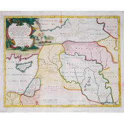
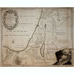
De Beyde Koningryken Juda en Israe¨l, die na Salomos dood zig van elkanderen afgescheurt hebben: benevens de Overheerde Landen . .
Bible map of the Kingdoms of Juda and Israel, with battle scene. Engraved by Jan van Jagen and published in a Dutch Bible by Nicolas Goetzee.Willem Albert Bachiene (1712-...
Date: Gorichem, Nicolaas Goetzee, 1748
Selling price: ????
Please login to see price!
Sold in 2016
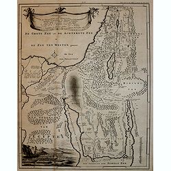
Afbeelding van 't Koningryk Israels, Benevens de door 't zelve Overheerde Landen. . .
Bible map with impressive scene of 1 Kings 10:22 The king (Solomon) had a fleet of trading ships at sea along with the ships of Hiram. Once every three years it returned,...
Date: Gorichem, Nicolaas Goetzee, 1748
Selling price: ????
Please login to see price!
Sold in 2016
AFBEELDINGE DER OOSTERSCHE LANDEN waarin zoo de X stammen Israels als de II overige van Juda gedurende den tijd hunner ballingschap verkeert hebben. . .
Bible map with nice view of Arabia Felix. Engraved by Jan van Jagen and published in a Dutch Bible by Nicolas Goetzee.Willem Albert Bachiene (1712-1783), Dutch geographer...
Date: Gorichem, Nicolaas Goetzee, 1748
Selling price: ????
Please login to see price!
Sold in 2016
AFBEELDING VAN EGYPTE, DE WOESTIJNE DER SCHELFZEE EN 'T LAND KANAAN. . .
Bible map with exodus scene. Engraved by Jan van Jagen and published in a Dutch Bible by Nicolas Goetzee.Willem Albert Bachiene (1712-1783), Dutch geographer in Maastrich...
Date: Gorichem, Nicolaas Goetzee, 1748
Selling price: ????
Please login to see price!
Sold in 2016
AFBEELDINGE VAN 'T LAND KANAAN. . .
Map of Canaan engraved by Jan van Jagen and published in a Dutch Bible by Nicolas Goetzee.Willem Albert Bachiene (1712-1783), Dutch geographer in Maastricht. Most importa...
Date: Gorichem, Nicolaas Goetzee, 1748
Selling price: ????
Please login to see price!
Sold in 2016
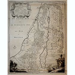
AFBEELDINGE VAN 'T LAND VAN ISRAEL NAAR DESZELFS NATUURLIJKE GESTELD. . .
Map of the Land of Israel engraved by Jan van Jagen and published in a Dutch Bible by Nicolas Goetzee.Willem Albert Bachiene (1712-1783), Dutch geographer in Maastricht. ...
Date: Gorichem, Nicolaas Goetzee, 1748
Selling price: ????
Please login to see price!
Sold in 2016
'T LAND KANAAN benevens GILEAD.
Map of the Land of Canaan engraved by Jan van Jagen and published in a Dutch Bible by Nicolas Goetzee.Willem Albert Bachiene (1712-1783), Dutch geographer in Maastricht. ...
Date: Gorichem, Nicolaas Goetzee, 1748
Selling price: ????
Please login to see price!
Sold in 2016
Afbeelding van alle de landen gelegen tusschen de Middelandsche, Zwarte, Caspische, Persische en Rode Zeën.
Bible map with scene of Adam and Eve expulsed from paradise. Engraved by Jan van Jagen and published in a Dutch Bible by Nicolas Goetzee. Willem Albert Bachiene (1712-178...
Date: Gorichem, Nicolaas Goetzee, 1748
Selling price: ????
Please login to see price!
Sold in 2016
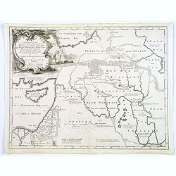
Afbeelding van all de Landen gelegen tusschen de Middellandsche, Zwarte, Caspische, Persische en Rode Zeën.
A map of the Near East, with an oversized Cyprus.Decorative, scrolled title cartouche to upper left corner. From a Dutch bible published by Nicolaas Goetzee. Willem Alber...
Date: Gorichem, Nicolaas Goetzee, 1748
Selling price: ????
Please login to see price!
Sold in 2020
![[2-sheets] Carte des Indes Orientales. . .](/uploads/cache/39110-250x250.jpg)
[2-sheets] Carte des Indes Orientales. . .
A lovely two sheet map (1000 x 860 mm) of the East Indies, drawn by Tobias Meyer for the Homann Heirs in 1748.The first sheet shows India as far north as Delhi, across to...
Date: Nurenberg, 1748
Selling price: ????
Please login to see price!
Sold in 2017
Karte von den Philippinischen Celebes und Molukkischen Eylanden.
Uncommon map of the Philippines, including a large part of Borneo, Sulawesi, the Moluccas, Bali, Timor, etc. With a small title cartouche and a box with German text.More ...
Date: Paris, 1748
Selling price: ????
Please login to see price!
Sold in 2017
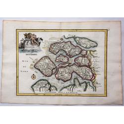
Zelande.
Hand colored copperplate map of the Dutch province of Zeeland by le Rouge from his “Atlas Nouveau Portatif “. Features cartouche of a putti holding a coat of arms and...
Date: Paris, 1748
Selling price: ????
Please login to see price!
Sold in 2017
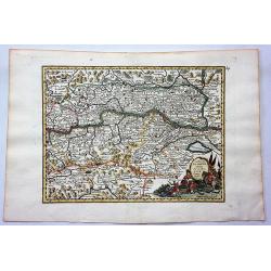
La Basse Autriche.
Fine detailed map of lower Austria by Le Rouge. Features a cartouche depicting a battle between soldiers.George Louis Le Rouge was active from 1740- till 1780 as a publis...
Date: Paris, 1748
Selling price: ????
Please login to see price!
Sold in 2018
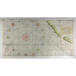
A Chart of the Pacific Ocean from the Equinoctial to the Latitude of 39 1/2d No.
This is a rare nautical chart of part of the Pacific Ocean displaying the routes of Spanish galleons between Acapulco and the Philippines. The tracks of the Spanish Nostr...
Date: London, 1748
Selling price: ????
Please login to see price!
Sold in 2017
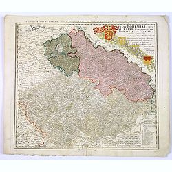
Regni Bohemiae, Duc. Silesiae, Marchionatuum Moraviae et Lusatiae. . .
Johann Baptist Homann's well-engraved map including the towns of Prague, Poznan/ Loda, Wroclaw, etc.Johann Baptist Homann (1663-1724) was a German engraver and publisher,...
Date: Nuremberg, 1748
Selling price: ????
Please login to see price!
Sold in 2018
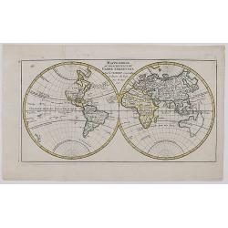
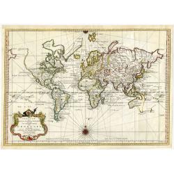
Mappe Monde ou Description Du Globe Terrestre . . .​
Double Hemisphere Map of the World, published in Paris in 1748. The map includes the mythical cartography of the time period, including an unknown Alaska and Northwest Co...
Date: Paris 1748
Selling price: ????
Please login to see price!
Sold in 2017
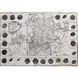
The Geography of the Great Solar Eclipse of July, 14 MDCCXLVIII : Exhibiting an accurate Map of all parts of the Earth in which it will be visible, with the North Pole, according to the latest discoveries.
An interesting map of much of the northern hemisphere. The map is surrounded by various views of the eclipse from different towns and cities around the world (Dublin, Edi...
Date: London, 1748
Selling price: ????
Please login to see price!
Sold in 2017
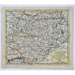
L'Archiduche D'Autriche et les Duches de Stirie, Cartinthie et Carniole.
A fine map of Inner Austria, or currently Austria, Slovenia and Hungary. This region referred to the Duchies and Habsburg hereditary lands. It was published in the 1748 e...
Date: Paris, 1748
Selling price: ????
Please login to see price!
Sold in 2017
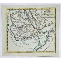
Nubie, Abissinie et Cote D'Ajan.
A fine map of Abyssinia, Sudan and the Red Sea covering Arabia, Egypt south to Mogadishu. It was published in the 1748 edition of the de Vaugondy's "ATLAS PORTRATIF ...
Date: Paris, 1748
Selling price: ????
Please login to see price!
Sold in 2023
(Atlas with 23 maps by Homann)
Homann composite atlas including a double-hemispherical world map, continental maps of Europe, Africa and Asia, and region specific maps of most European countries, like ...
Date: Nuremberg, 1748
Selling price: ????
Please login to see price!
Sold in 2019
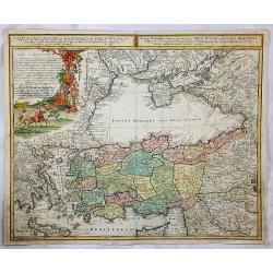
Carte de l'Asie Minevre. . .
A striking map centred on the Black Sea, and the geographical regions surrounding it. Map also shows Asia Minor, Crete, Cyprus, northern Syria, Iraq, Georgia, the Crimea,...
Date: Nuremburg, 1748
Selling price: ????
Please login to see price!
Sold in 2018
Regni Bohemiae, Duc. Silesiae, Marchionatuum Moraviae et Lusatiae. . .
Johann Baptist Homann's well-engraved map including the towns of Prague, Poznan/ Loda, Wroclaw, etc.Johann Baptist Homann (1663-1724) was a German engraver and publisher,...
Date: Nuremberg, 1748
Selling price: ????
Please login to see price!
Sold in 2020
Amérique Meridionale. . .
Uncommon wall map of South America published by d''Anville and engraved by the master Guilluime Delahaye. Prepared by de la Condamine.
Date: Paris, 1748
Selling price: ????
Please login to see price!
Sold in 2018
Versuch von einer kurzgefassen Karte welche die bekannten Theile der Erdkugel enthaelt ...
Detailed world map in Mercator projection showing the known parts of the globe, with cartouche and attractive compass rose.From a German edition of Bellin's Atlas 'Histoi...
Date: 1748
Selling price: ????
Please login to see price!
Sold in 2021