Browse Listings
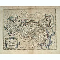
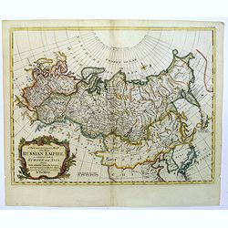
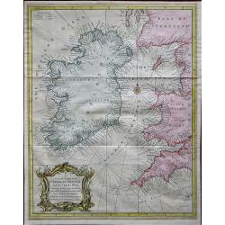
A New and Accurate Map of the Whole Russian Empire as contained both in Europe and Asia. . .
Detailed map of Russia, from the Sea of Anadyr, Sea of Kamchatka and the Kuril Islands to Poland. In the NW Coast of America references to Tschirikov's contact with Alask...
Date: London, c. 1747
Selling price: ????
Please login to see price!
Sold in 2013
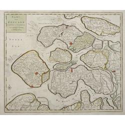
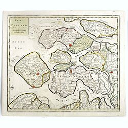
Kaart Van Zeeland.
Interesting map of the Dutch province of Zeeland depicting the individual islands in good detail. The fortified cities are highlighted in red.
Date: Amsterdam, 1747
Selling price: ????
Please login to see price!
Sold in 2013
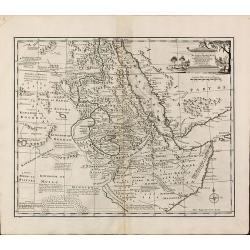
A New and Accurate Map of Nubia & Abissinia, Together with All the Kingdoms Tributary there...
Showing the area from lower Egypt, through Sudan and Ethiopia and down to Somalia. The map also includes the Red Sea and what is now Yemen and South Arabia. Blank on vers...
Date: London, 1747
Selling price: ????
Please login to see price!
Sold in 2013
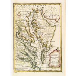
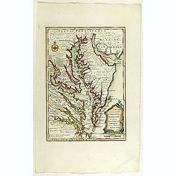
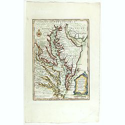
A New and Accurate Map of Virginia & Maryland. Laid Down from Surveys and Regulated by Astronl. Observatns
Uncommon map of the Chesapeake region, including only a thin strip of southern Pennsylvania, which is named but with nothing identified. Published by Bowen from 'A Comple...
Date: London, c.1747
Selling price: ????
Please login to see price!
Sold in 2016
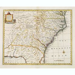
A new & accurate map of.. North & South Carolina, Georgia &c. c. Drawn from late Surveys and regulated by Astron.
An excellent early engraving of the American Southeast from the mouth of the Chesapeake to Northern Florida. Georgia occupies a very small area next to a large Florida. N...
Date: London, 1747
Selling price: ????
Please login to see price!
Sold in 2015
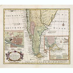
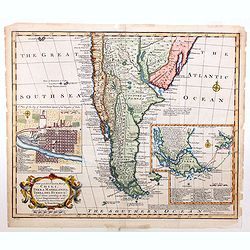
A New and Accurate Map of Chili, Terra Magellanica, Terra del Fuego &c. . .
Bowen's map of the southern part of South America from 'A Complete System of Geography'. With one title cartouche and a compass rose. With two inset maps, one of Santiago...
Date: London, 1747
Selling price: ????
Please login to see price!
Sold in 2016
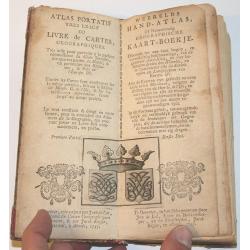
Atlas Portatif.
Small hand atlas of the world with 33 of 34 maps. Map nr. 4 (De Nieuwe en Ouden Oppervlakke en Doorzigtkundige Aardryks Bollen) is missing. The title page and register ar...
Date: Almelo, 1747
Selling price: ????
Please login to see price!
Sold in 2013
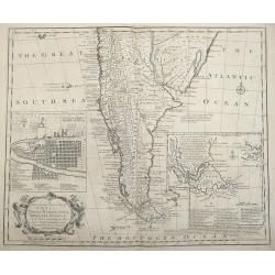
A new and accurate map of Chili, Terra Magellanica, Terra del Fuego &c. Laid down according to the latest improvements and regulated by astronl. observatns. By Eman: Bowen.
Full Title as it appears on the map, A new and accurate map of Chili, Terra Magellanica, Terra del Fuego &c. Laid down according to the latest improvements and regula...
Date: London, 1747
Selling price: ????
Please login to see price!
Sold in 2014

Francis Drake.
Fine hand-colored copperplate engraving featuring Francis Drake, the famous pirate. From "Heads of Illustrius Persons of Great Britain" by Thomas Birch. Engrave...
Date: London, 1747
Selling price: ????
Please login to see price!
Sold in 2013
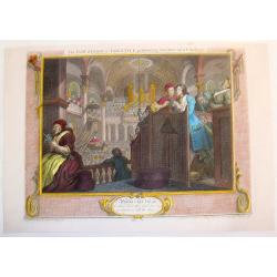
The Industrious Apprentice Performing the Duty of a Christian.
Fine, large, copper engraved Hogarth print featuring the industrious apprentice singing in the choir. William Hogarth (1697 – 1764) was an English painter, printmake...
Date: London, 1747
Selling price: ????
Please login to see price!
Sold in 2013
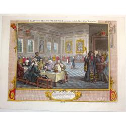
The Industrious Apprentice Grown Rich & Sheriff of London.
Fine large, copper engraved, hand-colored print featuring the industrious apprentice as the Sheriff of London. William Hogarth (1697 – 1764) was an English painter, p...
Date: London, 1747
Selling price: ????
Please login to see price!
Sold in 2013
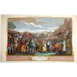
The Idle Apprentice Executed at Tyburn.
Fine, large, hand-colored copper engraving featuring a crowd gathering to watch the execution of the Idle Apprentice. William Hogarth (1697 – 1764) was an English pai...
Date: London, 1747
Selling price: ????
Please login to see price!
Sold in 2013
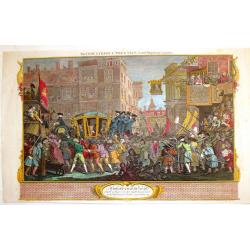
The Industrious Apprentice - Lord-Mayor of London.
Fine, large, hand-colored copper engraving featuring the industrious apprentice riding in a carriage in London. William Hogarth (1697 – 1764) was an English painter, ...
Date: London, 1747
Selling price: ????
Please login to see price!
Sold in 2013

The Idle Apprentice Returned From Dea & in a Garret With a Common Prostitute.
Fine, large, hand-colored, copper engraving featuring the idle apprentice with a prostitute. William Hogarth (1697 – 1764) was an English painter, printmaker, , picto...
Date: London, 1747
Selling price: ????
Please login to see price!
Sold in 2013
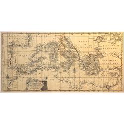
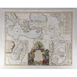
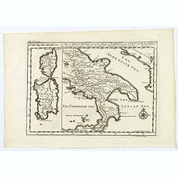
An accurate chart of the Mediterranean and Adriatic Sea. . .
An excellent early engraving of the Mediterranean and Adriatic Sea.
Date: London, 1747
Selling price: ????
Please login to see price!
Sold in 2014
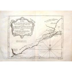
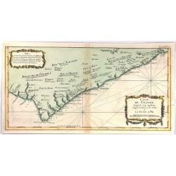
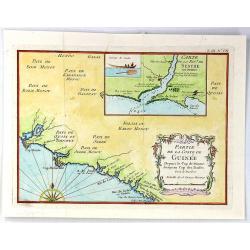
Suite de la Coste de Guinnee Deouis la Riviere de Volta Jusqu'a Jakin.
Fine detailed map of the African Guinea coast, west of the Volta River. Featuring the kingdoms of Koto, de Popo, de Whidah and Ardra.Engraved by J. Schley from atlas of P...
Date: Paris, 1747
Selling price: ????
Please login to see price!
Sold in 2015
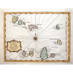
Carte des Isles du Cap Verd.
Striking map of the Cape Verde Islands off the coast of Africa. Fancy cartouche and interesting, unique compass rose.By Bellin from the Abbe Prevost d'Exiles.
Date: Paris, 1747
Selling price: ????
Please login to see price!
Sold in 2016
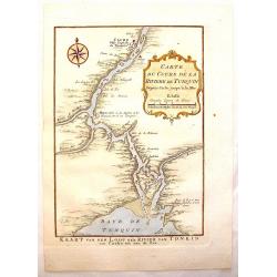
Carte du Cours de la Riviere de Tunquin.
Handsome hand colored map of the Tonkin River from Ho Chi Mingh to the Gulf of Tonkin. The map provides fine detail of the region and is embellished with a compass rose a...
Date: Paris, 1747
Selling price: ????
Please login to see price!
Sold in 2015
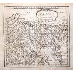
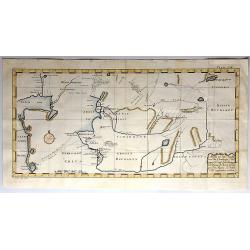
Suite de la Carte de la Siberie et le Paijs de Kamtfchatka.
A detailed map of Russia covering the coast of Siberia and Kamchatka, the island of Sakhalin and part of Tatary. Near the top is the voyage track of Semen Dezhnev who led...
Date: Paris, 1747
Selling price: ????
Please login to see price!
Sold in 2015
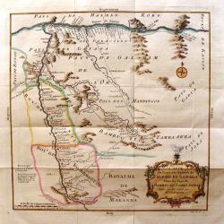
Carte du Cours des Rivieres de Faleme et Sanaga dans les Pays de Bambuc et Tamba Awra.
An interesting map of the Faleme and Sanaga Rivers in Camaroon in Africa. The map by Jacques Bellin has a decorative title cartouche.
Date: Paris, 1747
Selling price: ????
Please login to see price!
Sold in 2016
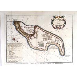
Plan de L'Isle de Gore avec ses Fortifications.
Fine plans of Isle Gore, one of the main sites from which thousands of slaves were loaded on to ships bound for the New World. Engraved by J.V. Schley in 1747. From Abbe...
Date: Paris, 1747
Selling price: ????
Please login to see price!
Sold in 2016
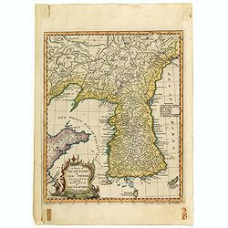
A map of Quan-Tonge province and the kingdom of Kau-Li or Korea.
Detailed map of Korea, Liaodong, and the tip of Shandong Province prepared by Thomas Kitchin for Thomas Salmon's "Universal Traveller", based on D'Anville's lan...
Date: London, 1747
Selling price: ????
Please login to see price!
Sold in 2023
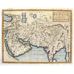
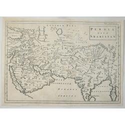
Persia Sive Shahistan.
Map of ancient western and southern Asia. The map is centered on Persia, but extends from Cyprus to east of the Ganges and as far north as the Caspian Sea. It uses the na...
Date: London, 1747
Selling price: ????
Please login to see price!
Sold in 2015
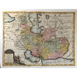
A New & accurate Map of Persia, with the Adjacent Countries.
A fine map of the Persian Empire including present day countries of Afghanistan, Iraq and Iran. Decorated with a pictorial title cartouche. Published in 1747 in Bowen’...
Date: Paris, 1747
Selling price: ????
Please login to see price!
Sold in 2015
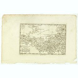
A Map of Great Tibet drawn from that made by Lama Mathematicians in 1717.
Uncommon map of the Gobi Desert, Kashgar regions with Tibet. Drawn from indigenous sources, including the Dalai Lama's mathematicians and engraved by G. Child - with his ...
Date: London, 1745-1747
Selling price: ????
Please login to see price!
Sold in 2015
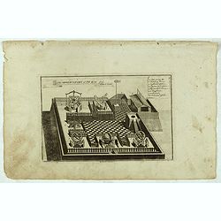
The observatory of Pe-kin from Le Comte.
Print of the observatory of Peking after Le Comte who visited the Peking Observatory in 1688. Engraved by G. Child - with his signature in lower bottom.From Astley, Thoma...
Date: London, 1745-1747
Selling price: ????
Please login to see price!
Sold in 2016
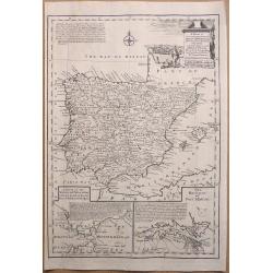
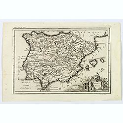
A New & Accurate Map of Spain & Portugal Drawn from the latest Surveys & most approved Maps & Charts The whole being adjusted by Astron Observations. By Emanuel Bowen
A fine Emanuel Bowen map of Spain and Portugal with two inset plans – ‘The Harbour of Port Mahon’ and ‘A Chart of the Straits of Gibraltar, with the Coast of Spai...
Date: London, 1747
Selling price: ????
Please login to see price!
Sold in 2017
Coste de Guinee Depuis le Cap Apollonia Jusqu'a la Riviere de Volta ou La Coste d'Or.
Bellin's detailed map of the Guinea coast in west Africa, from Cape Appollonia to the mouth of the Volta River in what is now Ghana (the Gold Coast), from the atlas of Pr...
Date: Paris, 1747
Selling price: ????
Please login to see price!
Sold in 2016
Carte des voyages de Notre seigneur Jesus Christ. . .
Showing eastern part of the Mediterranean, including Cyprus, Italy. Lower right hand corner inset plan of Jerusalem. Lower left map of Palestine. Published by Vaugondy, a...
Date: Paris, 1747
Selling price: ????
Please login to see price!
Sold in 2022
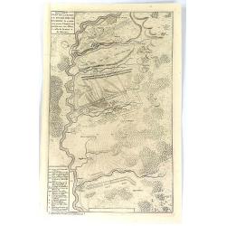
Nouveau Plan de la Bataille Donnee Pres de Hochstet ....
The Battle of Blenheim (referred to in some countries as the Second Battle of Höchstädt), fought on 13 August 1704, was a major battle of the War of the Spanish Success...
Date: Amsterdam, 1747
Selling price: ????
Please login to see price!
Sold in 2019
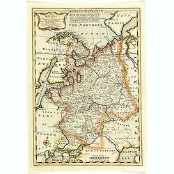
A New and Accurate map of the Whole Russian Empire, as contained both in Europe and Asia...
A pleasant map, by the English cartographer Thomas Kitchin, of the vast Russian Empire, as it was during the middle of the eighteenth century.The map has been colored to ...
Date: London, 1747
Selling price: ????
Please login to see price!
Sold in 2017
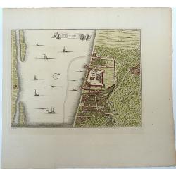
![A Chart of the South part of Cephalonia, with the Islands of Zante and the Coast of Morea ... [on sheet with] A Chart of the South Coast of Morea from Venetica to CS. Angelo](/uploads/cache/97451-250x250.jpg)
A Chart of the South part of Cephalonia, with the Islands of Zante and the Coast of Morea ... [on sheet with] A Chart of the South Coast of Morea from Venetica to CS. Angelo
This two part sea chart features the island of Zante and Cephanolia on the left side, and Serigo to Candia (Crete) on the right. Engraved by 'J[oel] Gas[coyne]' this plat...
Date: 1747
Selling price: ????
Please login to see price!
Sold in 2016
A Chart of the Islands Corfu, Pachsu and Antipachsu with ye Channel and Roads between the Island of Corfu & ye Graetian Coast
A superb rare sea chart with rhumb lines of Corfu and nearby coastlines. The main town and castle in Corfu is clearly outlined. It is engraved by 'J[oel] Gascoyne' and wa...
Date: 1747
Selling price: ????
Please login to see price!
Sold in 2016
A New & Accurate Map of Moscovy, or Russia in Europe, with its Acquisitions.
A quaint detailed map of European Russia by Emmanuel Bowen.
Date: London, 1747
Selling price: ????
Please login to see price!
Sold in 2016
Kaart van Zeeland.
Map of the province of Zeeland, with the fortified cities are highlighted in red. Isaac Tirion was born in Utrecht ca. 1705. He came to Amsterdam ca. 1725. Tirion publish...
Date: Amsterdam, 1747
Selling price: ????
Please login to see price!
Sold in 2016
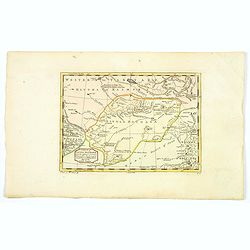
Anhang zu dem Karten von dem Orenburger.
Copper engraved map of Siberia, Russia, from the Caspian Sea to Tashkent, in Uzbekistan. The map depicts the Aral–Caspian Depression, a lowland depression straddling Eu...
Date: Germany, 1747
Selling price: ????
Please login to see price!
Sold in 2018
![A Map of Little Bochara, and the Adjacent Countrys... [and] The Empire of Hya (including grear part of Tangul)...](/uploads/cache/38612-250x250.jpg)
A Map of Little Bochara, and the Adjacent Countrys... [and] The Empire of Hya (including grear part of Tangul)...
A pair of uncommon maps of the Gobi Desert and Bochara region.Engraved by Thomas Kitchin - with his signature in lower bottom.From Astley, Thomas, "A New General Col...
Date: London, 1745-1747
Selling price: ????
Please login to see price!
Sold in 2016
Partie de la Coste de Guinee Depuis le Cap de Monte Jusqu'au Cap des Basses;
A fine little map engraved by Schley featuring the coast of Guinee in Western Africa. The insert is of the Sestos River.With a pleasing floral, title cartouche. The map w...
Date: Paris, 1747
Selling price: ????
Please login to see price!
Sold in 2019
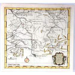
Kurtz von Ernigen Provinzen in Siberien und den Groenzen Yegen China
An unusual antique map of central Siberia featuring Tomsk, Krasnoarsk and Kuznets Oblests (provinces). The bottom of the map borders on China. It features a fancy floral ...
Date: Germany, 1747
Selling price: ????
Please login to see price!
Sold in 2017
A Map of Little Bochara, and the Adjacent Countrys...
Uncommon map of the Bochara region.Engraved by Thomas Kitchin - with his signature in the lower bottom.From Astley, Thomas, "A New General Collections of Voyages and...
Date: London, 1745-1747
Selling price: ????
Please login to see price!
Sold in 2017
![A Map of Little Bokhara, and the Adjacent Countrys... [and] The Empire of Hya (including grear part of Tangul)... [2 maps]](/uploads/cache/40038-250x250.jpg)
A Map of Little Bokhara, and the Adjacent Countrys... [and] The Empire of Hya (including grear part of Tangul)... [2 maps]
A pair of uncommon maps of the Gobi Desert and Bochara region of Central Asia and Western China.Engraved by Thomas Kitchin. From Astley's, "A New General Collections...
Date: London, 1745-1747
Selling price: ????
Please login to see price!
Sold in 2019
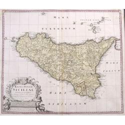
Regni & Insulae Siciliae Tabula geographica ex Archetypo...
A fine and detailed map of Sicily and the Aeolian Islands. Includes many towns, roads, mountains, rivers, bays, etc. Decorated with a large cartouche.
Date: Nuremberg, 1747
Selling price: ????
Please login to see price!
Sold in 2017
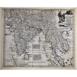
A New and Accurate Map of the Empire of the Great Mogul, Together with India on Both Sides the Ganges, and the Adjacent Countries.
A copper engraved map. Finely engraved map centered on the mouth of the Ganges, and covering India, Pakistan, Thailand, Ceylon, Siam, Laos, Cambodia, part of Tibet, and t...
Date: London, ca. 1747
Selling price: ????
Please login to see price!
Sold in 2017
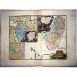
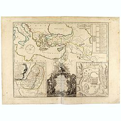
Terre de Chanaan ou terre promise à Abraham et à sa postérité ; Carte des voiages d'Abraham faits par l'ordre de Dieu, en Asie et en. . .
A large and rare copper engraved sheet with 2 maps of the Holy Land, or 'promised land to Abraham', includes also the route of Moses and the Israelites as they wandered t...
Date: Paris, ca 1747
Selling price: ????
Please login to see price!
Sold in 2021
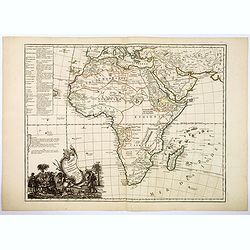
L'Afrique Suivant les Dern.res Observations de Mr. Hass et des R.R.P.P. Jesuites.
A large map of the continent of Africa with a decorative title cartouche. Informational table upper left explaining the countries that comprise northern and southern Afri...
Date: Paris, 1747
Selling price: ????
Please login to see price!
Sold in 2017
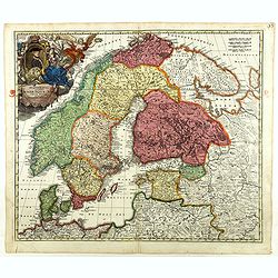
Scandinavia complectens Sueciae, Daniae & Norvegia. . .
Johann Baptist Homann's well-engraved map has a large decorative cartouche. Detailed map of Scandinavia.Johann Baptist Homann (1663-1724) was a German engraver and publis...
Date: Nuremberg, 1747
Selling price: ????
Please login to see price!
Sold in 2018
A New & Accurate Map of Moscovy, or Russia in Europe, with its Acquisitions.
A detailed map of European Russia by Emmanuel Bowen. It depicts the European portion of Russia extending from the Gulf of Finland to the Ural Mountains. The map offers ex...
Date: London, 1747
Selling price: ????
Please login to see price!
Sold in 2018
A New and Accurate Map of Virginia & Maryland.
Scarce map of the Chesapeake region by Bowen.
Date: London, c.1747
Selling price: ????
Please login to see price!
Sold in 2019
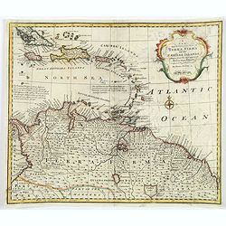
A New and Accurate Map of Terra Firma and the Caribbe Islands.
This is Emmanuel Bowen's attractive, decorative map of the Caribbean Islands, extending from eastern Cuba and Jamaica to Trinidad, and northern South America (Columbia, V...
Date: London, ca 1747
Selling price: ????
Please login to see price!
Sold in 2018
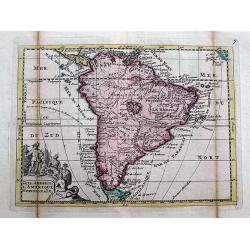
Zuyd America. L'Amerique Meridionale.
An unusual map of South America in an early shape and with two mythological lakes. The track of Jacques Le Maire is shown in the Pacific. Above the title cartouche, nativ...
Date: Amsterdam, 1747
Selling price: ????
Please login to see price!
Sold in 2018
Carte des Voyages de Notre Seigneur Jesus Christ. . .
A decorative map of the Eastern Mediterranean and contiguous regions, with a large inset plan of Jerusalem and inset map of Judea at the time of King Herod. The main map...
Date: Paris, 1747
Selling price: ????
Please login to see price!
Sold in 2019
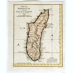
Isle de Madagascar autrement Isle de St. Laurent . . .
Detailed map of the island of Madagascar, from Jacques-Nicolas Bellin (1703-1772) the most important mapmakers of the 18th Century.
Date: Paris, 1747
Selling price: ????
Please login to see price!
Sold in 2022
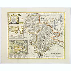
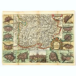
A New and Accurate Map of Savoy, Piedmont, and Montferrat. . .
This is the striking 1747 map of Savoy, Piedmont and Montserrat in northern Italy by Emanuel Bowen. It covers part of modern day France and Italy from Lake Geneva south a...
Date: London, 1747
Selling price: ????
Please login to see price!
Sold in 2018
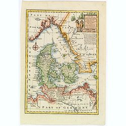
A New and Accurate map of Denmark.
This is the beautiful 1747 map of Denmark by the British cartographer Emanuel Bowen. It covers all of Jutland and the islands of Zealand, Funen and Lolland. Parts of sout...
Date: London, 1747
Selling price: ????
Please login to see price!
Sold in 2020
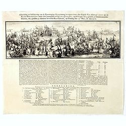
Afbeelding en befchrying van de Roemrugtige Overwinning bevogten door den Engelfe Vice- Admiral Anson . . .
Broad - sheet copper engraving with letter press. Spectacular etching by Romein de Hooghe. With letterpress describing the First Battle of Cape Finisterre (14 May 1747. 1...
Date: Amsterdam, 1747
Selling price: ????
Please login to see price!
Sold in 2020
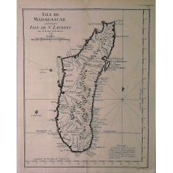
Isle de Madagascar Autrement Isle de St. Laurent.
An attractive map of the island of Madagascar marking its settlements and topography, by Bellin from Prevost's "Histoire Generale des Voyages".Jacques Nicolas B...
Date: Paris, 1747
Selling price: ????
Please login to see price!
Sold in 2020
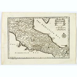
Middle or Proper Italy.
A map of central Italy, from Roman times, and published in "An Universal History from the Earliest Account of Time to the Present". With a quaint title cartouch...
Date: London, ca 1747
Selling price: ????
Please login to see price!
Sold in 2019
A Map of Great Greece and of the Islands of Sardinia and Corsica. . .
A map showing the islands of Sardinia and Corsica, and southern Italy to the northern tip of Sicily in roman times. From "An Universal History, from the Earliest Acc...
Date: London, 1747
Selling price: ????
Please login to see price!
Sold in 2020
Antient Spain.
A nice map of Ancient Spain, published in "An Universal History from the Earliest Account of Time to the Present". It shows Spain in Roman times, with Latin spe...
Date: London, 1747
Selling price: ????
Please login to see price!
Sold in 2019
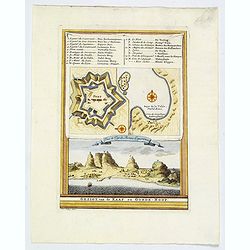
Gezigt van de Kaap de Goede-Hoop.
A small view of the Cape of Good Hope, and featuring a plan of the fort and map of the bay. There is also a numbered table (1-14) at top. Engraved when the Dutch had a co...
Date: Amsterdam, 1747
Selling price: ????
Please login to see price!
Sold in 2019
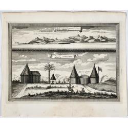
Vue des Montagnes nommées Sierra Leona.
Two views of Sierra Leone. French & Dutch text.
Date: Amsterdam, 1747
Selling price: ????
Please login to see price!
Sold in 2019
![[2 prints] Cadaver balsamo conditum... / Loculi Conspectus anterior auctior...](/uploads/cache/82536-250x250.jpg)
[2 prints] Cadaver balsamo conditum... / Loculi Conspectus anterior auctior...
Two attractive copper-engravings showing a sarcophagus in great detail. Engraved by James Basire, drawn by George Vertue, published in the first volume of Vetusta Monumen...
Date: London, 1747
Selling price: ????
Please login to see price!
Sold in 2019
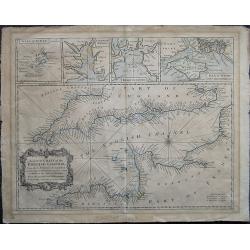
A Correct Chart of St. Georges Channel and the Irish Sea, Including all the Coast of Ireland, and ye West Coast of Great Britain from Cantire to Portland Isle: From the latest & best Observations.
A 1747 nautical chart or maritime map of Ireland and the St. Georges Channel. Engraved by R. W. Seale, the map covers the whole of Ireland as well as adjacent parts of Sc...
Date: London, 1747
Selling price: ????
Please login to see price!
Sold in 2019
A correct Chart of the English Channel - From the No. Foreland to the Lands End on the Coast of England, and from Calais to Brest on the Coast of France . . .
The English Channel, featuring insets of the Isles of Scilly, Falmouth Haven, Plymouth Sound and the Isle of Wight and ye adjacent Harbours. Alderney, Guernsey, Jersey an...
Date: London, 1747
Selling price: ????
Please login to see price!
Sold in 2020
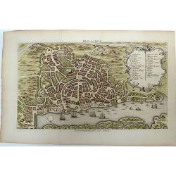
Plan de Goa. Grondtekening van Goa.
A beautifully detailed and engraved town-plan of the Portuguese colony of Goa in India, with a number key (1-29) to the city's major monuments and sites, enclosed in a de...
Date: Amsterdam, 1747
Selling price: ????
Please login to see price!
Sold in 2020
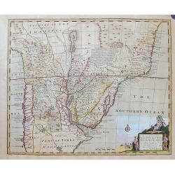
A New and Accurate Map of Paraguay, Rio De La Plata, Tucumania Guaria &c. . .
A fine and decorative map of south central South America from Bowens Atlas "A Complete System of Geography". With a cartouche illustrating natives and European ...
Date: London, ca 1747
Selling price: ????
Please login to see price!
Sold in 2019
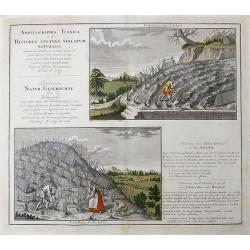
Ampelographia Iconica id est, Historia culturae Vinearum Naturalis...
A scarce print, illustrating viniculture with two images showing vineyards and winegrowers. Explanatory German text about cultivating and cutting the vines.
Date: Nuremberg, 1747
Selling price: ????
Please login to see price!
Sold in 2019
A New and Accurate Map of Virginia & Maryland. Laid Down from Surveys and Regulated by Astronl. Observatns
Scarce map of the Chesapeake region by Bowen from 'A Complete System of Geography'. Based on Hermann's map of 1673 and Popple's map of 1733. Showing numerous early towns ...
Date: London, c.1747
Selling price: ????
Please login to see price!
Sold in 2020
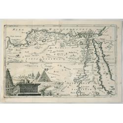
A Map of Ancient Egypt.
A detailed map of Egypt on the Red Sea with Nubia, Arabia by Cellerius in 1747. It features a cartouche of the pyramids.Andreas Cellarius (1596-1665) was an astronomer, m...
Date: Amsterdam, 1747
Selling price: ????
Please login to see price!
Sold in 2020
Persia Sive Shahistan.
The map shows Great Persia included Syria, Armenia, Arabia, Iran, Iraq and India, by Cellerius in 1747. Andreas Cellarius was an astronomer, mathematician and cosmograp...
Date: Amsterdam, 1747
Selling price: ????
Please login to see price!
Sold in 2023
Jaffenapatnam.
A bird's eye perspective of the fort and town of Jaffna. The view depicts Jaffnapatnam, the fort on the coast of Sri Lanka. This Portuguese built fort was captured by the...
Date: Amsterdam, 1747
Selling price: ????
Please login to see price!
Sold in 2020
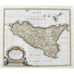
Regni & Insulae Siciliae tabula geographica...
A very detailed map of Sicily and surrounding smaller islands (Lipari, Stromboli, Ustica, etc.). Shows the Etna volcano, rivers, hills, roads, and many place names. With ...
Date: Nuremberg, ca. 1747
Selling price: ????
Please login to see price!
Sold in 2021
Duche de Baviere. Het Hertogdom Byeren.
A decorative and very detailed map of Bavaria in southern Germany, first drawn by Daniel de la Feuille in 1706 that includes Munich and Augsburg. Surrounded by thirteen m...
Date: Paris, 1747
Selling price: ????
Please login to see price!
Sold in 2021
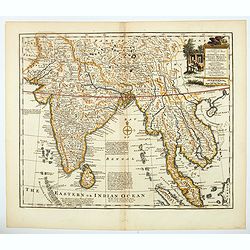
A new & accurate map of the Empire of the Great Mogul.
A decorative map of India, Central Asia, Siam, the Straits of Malacca and parts of Borneo, Sumatra and China, it also incudes the Maldives and the Andaman Islands. It inc...
Date: London, 1747
Selling price: ????
Please login to see price!
Sold in 2021
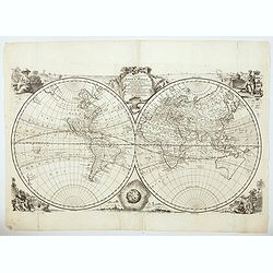
A new & accurate map of all the known world. . .
A decorative very double hemisphere view of the world surrounded by vignettes of indigenous women representing all the continents, the moon, and with an attractive title ...
Date: London, 1747
Selling price: ????
Please login to see price!
Sold in 2021
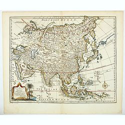
A new & accurate map of Asia drawn from actual surveys. . .
An excellent early engraving of Asia. There is a curious shape for Japan, with a large island north called Yedso and a coastline marked De Gamma's Land. The map renders t...
Date: London, 1747
Selling price: ????
Please login to see price!
Sold in 2021
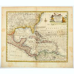
An accurate map of the West Indies : drawn from the best authorities, assisted by the most approved modern maps and charts, and regulated by astronomica. . .
An excellent early engraving of the West Indies and including American east cost with Florida, Gulf Coast, Texas, coast till Baltimore, Caribbean and Central America. Geo...
Date: London, 1747
Selling price: ????
Please login to see price!
Sold in 2021
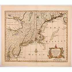
A New and Accurate Map of N. Jersey, Pensilvania, New York. . .
A scarce map of New Jersey, New York, Pennsylvania, Maine, New Hampshire and Connecticut. Canada extends south to the Pennsylvania border. Published by E. Bowen from A Co...
Date: London, 1747
Selling price: ????
Please login to see price!
Sold in 2021
A new and accurate map of Chili, Terra Magellanica. . .
A delightful map of the southern part of South America from A Complete System of Geography. With one title cartouche and a compass rose. With two inset plans, a beautiful...
Date: London, 1747
Selling price: ????
Please login to see price!
Sold in 2021
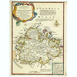
A New and Accurate Map of the Island of Antigua or Antego. . .
Bowen's maps of Antigua from A Complete System of Geography.. Decorated with a compass rose and a title cartouche. With extensive details and interesting annotations abou...
Date: London, 1747
Selling price: ????
Please login to see price!
Sold in 2023