Browse Listings
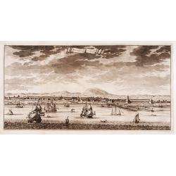
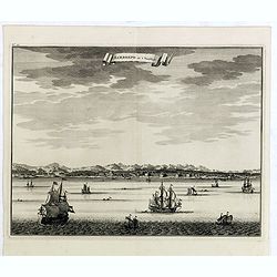
MACASAR, Capitale de Roiaume de meme nom.
A copperplate engraving that originates from the very scarce: 'La galerie agreable du monde. Tome premier des Indes Orientales.', published by P. van der Aa, Leyden, ca 1...
Date: Leiden, 1725
Selling price: ????
Please login to see price!
Sold in 2019
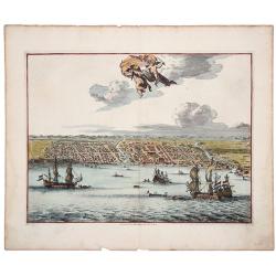
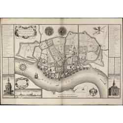
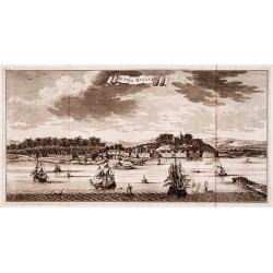
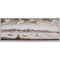
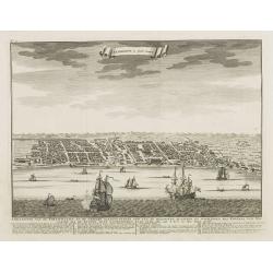
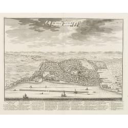
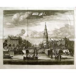
Batavia, L'an 1629.
Scarce town-view of Batavia (Jakarta) in 1629.From the French reissue of the account of early Dutch voyages first published in 1608 by Commelin. The French translation wa...
Date: Amsterdam, 1725
Selling price: ????
Please login to see price!
Sold in 2020
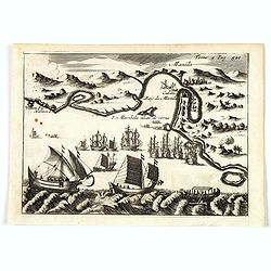
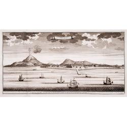
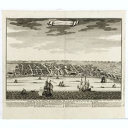
Manila.
A rare and important early engraving of the Bay and city of Manila as visited by the Dutch fleet of Joris van Spilbergen in March 1616. The Dutch fleet are seen to be app...
Date: Amsterdam, 1725
Selling price: ????
Please login to see price!
Sold in 2019
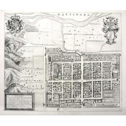
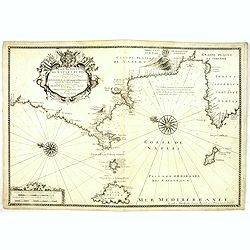
Gattinara.
A superb town plan of Gattinara, a village in the Piedmont region in Italy, between Torino, Vercelli and Lago Maggiore. It is situated near the Sesia river. Published in ...
Date: Amsterdam, 1668-1725
Selling price: ????
Please login to see price!
Sold in 2020
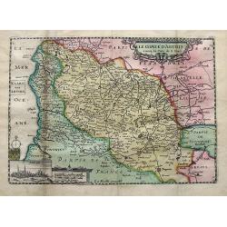
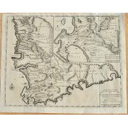
Le comte d'Artois. . .
A detailed map of Artois with an inset view of Arras. Decorated with old hand color, a title cartouche, small coat of arms, compass rose, and distance scale.
Date: Paris, ca 1725
Selling price: ????
Please login to see price!
Sold in 2019
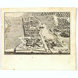
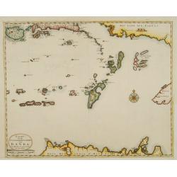
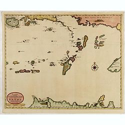
![Les Iles de BANDA [Indonesia].](/uploads/cache/83246-250x250.jpg)
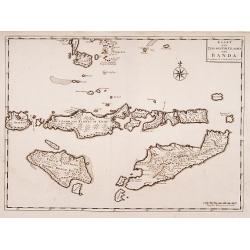
Les Iles de BANDA [Indonesia].
This plate originates from the very scarce: 'La galerie agreable du monde (...). Tome premier des Indes Orientales.', published by P. van der Aa, Leyden, ca. 1725. This f...
Date: Leiden, 1725
Selling price: ????
Please login to see price!
Sold in 2019
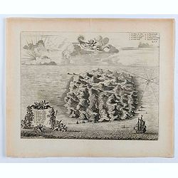
Isle St. Hélène.
This bird's eye view shows the Island of Saint Helena in the South Atlantic Ocean. With decorative title cartouche, legend / key, compass rose and ships.This plate origin...
Date: Leiden, ca. 1725
Selling price: ????
Please login to see price!
Sold in 2020
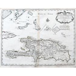
Carte de l'Isle de Saint Domingue Dressee en 1722. . .
An excellent map of Hispaniola with many details: Towns are connected with roads, many small rocks and islands shown, including Tortuga. Extends to show a tip of Cuba, an...
Date: Paris, 1725
Selling price: ????
Please login to see price!
Sold in 2020
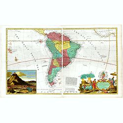
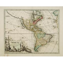
...this map of South America...
Map of South America including part of Central America. Cartographic elements include lines of latitude and longitude, compass rose, indication of wind directions, locati...
Date: London 1725
Selling price: ????
Please login to see price!
Sold in 2021

Carte Marine De La Mer Caspiene levée suivant les ordres de S.M.Cz. En 1719, 1720 et 1721.
Detailed of the Caspian Sea, prepared by Karl van Verden in 1722. Van Verden was a Russian sailor and the Czar's Special Commander, who produced the first accurate map of...
Date: Paris, ca. 1725
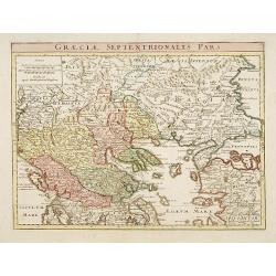
Graeciae Septentrionalis Pars.
A very striking map of northern Greece. From Schul-und-Reisen Atlas..
Date: Nuremberg 1725
Selling price: ????
Please login to see price!
Sold
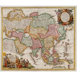
Asia cum omnibus Imperiis, Provinciis, Statibus et ..
A finely engraved and decorative mid-18th century map published in Augsburg, Germany and incorporating two large decorative title cartouches upper right and bottom left. ...
Date: Augsburg 1725
Selling price: ????
Please login to see price!
Sold
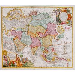
Asia cum omnibus Imperiis, Provinciis, Statibus et ..
A finely engraved and decorative mid-18th century map published in Augsburg, Germany and incorporating two large decorative title cartouches upper right and bottom left. ...
Date: Augsburg 1725
Selling price: ????
Please login to see price!
Sold
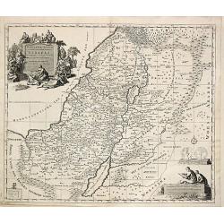
Carte de la Terre Sainte divisée selon les Douze Tribus d'Israel.
After the death of the widow of Pieter Mortier in 1719, the firm continued till 1778 as Covens & Mortier. They published numerous atlases and pocket atlases, using ma...
Date: Amsterdam, 1725
Selling price: ????
Please login to see price!
Sold
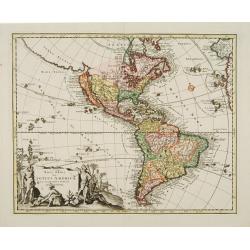
Novi Orbis Sive Totius Americae Cum Adiacentibus Insulis..
A double-page copper-engraved map, with original full coloring. The state with in the extreme north Pacific the key Gold-Catholisch Erdfarb Heydnisch [Gold = Catholic/ Ea...
Date: Nuremberg 1725
Selling price: ????
Please login to see price!
Sold
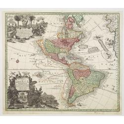
Novi Orbis Sive Totius Americae Cum Adiacentibus Insulis..
A double-page copper-engraved map, with original full coloring. California is a 1500-mile-long island, with the Strait of Anian Fretum Aniani due north and Anian an eastw...
Date: Nuremberg 1725
Selling price: ????
Please login to see price!
Sold
Novus Orbis sive America Meridionalis et Septentrionalis..
A finely engraved and decorative mid-18th century map published in Augsburg, Germany and incorporating two large decorative title cartouches upper right and bottom left. ...
Date: Augsburg 1725
Selling price: ????
Please login to see price!
Sold
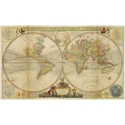
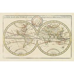
A new and correct map of the world..
A map in two hemispheres, printed from two plates. Moll's map was one of the first to record wind directions based on sustained scientific observations. At the bottom of ...
Date: London, 1725
Selling price: ????
Please login to see price!
Sold in 2010
A new map of the world according to the New Observations..
A map in two hemispheres, showing California as an island. In top smaller inset of the North Pole.
Date: London, 1725
Selling price: ????
Please login to see price!
Sold in 2009
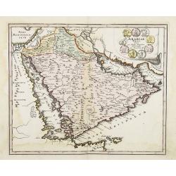
Arabiae Veteris.
Striking map of the ancient Arabian Peninsular. Title cartouche embellished with colored ancient coins.
Date: Nuremberg, 1725
Selling price: ????
Please login to see price!
Sold in 2008
Scena Historiarum Occidentalis Quinti Seculi P.N. CHR.
A very striking map of Europe. Decorated with a hemisphere of North and South America, annotated with various commentaries in Latin.
Date: Nuremberg, ca 1725
Selling price: ????
Please login to see price!
Sold in 2008
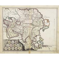
Asia Vetus per Christoph Weigelium. . .
A very striking map of the ancient Arabian Peninsular, embellished with an colored pictorial title cartouche.
Date: Nuremberg 1725
Selling price: ????
Please login to see price!
Sold in 2008
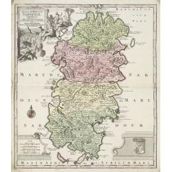
Insula et Regnum Sardiniae . . .
Kingdom of Sardinia. With arms lower right and a cartouche upper left of figures and animals in a landscape.
Date: Paris, ca. 1725
Selling price: ????
Please login to see price!
Sold in 2009
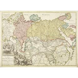
Carte nouvelle de tout l'empire de la grande Russie dans l'estat ou il s'est trouvé à la.mort de Pierre le Grand. . .
Rare map showing the Empire of Peter I the Great at the time of his death in 1723. Lower right a large title cartouche with a portrait of Peter I the Great or Pyotr Alexe...
Date: Amsterdam, ca. 1723-1725
Selling price: ????
Please login to see price!
Sold in 2010
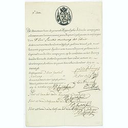
Very rare share in the Ostend Company.
Upper left hand corner share number "300" in manuscript. In top emblem of the Company in copper engraving. Text: " De Directeurs van de generale Keijserlij...
Date: Antwerp, 1723-1725
Selling price: ????
Please login to see price!
Sold in 2014
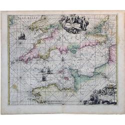
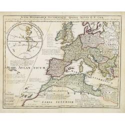
Canalis inter Angliae et Galliae Littera (English Channel)
This map was originally made and published by Frederick de Wit. The plate was acquired by the Ottens brothers after the death of De Wit's son in 1706. Following the gener...
Date: Amsterdam, ca. 1725
Selling price: ????
Please login to see price!
Sold in 2010
Ichnographia Burgi perantiqui Lennae regis in Agro Norfolciensi accurate delineata Ano MDCCXXV.
Important and very rare plan of King's LynnA large and detailed copper engraved plan of King's Lynn Harbour in Norfolk, drawn and published by Gulielmus Rastrick in 1725....
Date: London, 1725
Selling price: ????
Please login to see price!
Sold in 2010
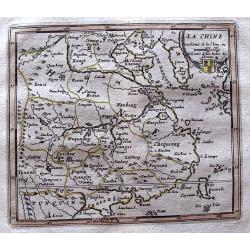
La Chine.
Scarce map based on a map published by Nicholas DeFer in Paris.
Date: Antwerp, 1725
Selling price: ????
Please login to see price!
Sold in 2012
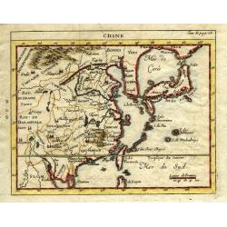
Chine.
Very uncommon state of Chevigni's map of China based on De L'Isle from "La Science des Personnes de la Cour..." published by Lottin, Genneau, and Morin. The map...
Date: Paris, 1725
Selling price: ????
Please login to see price!
Sold in 2011
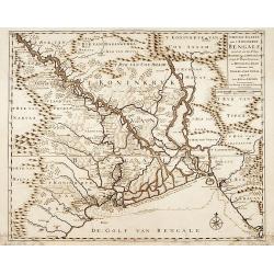
Nieuwe kaart van 't Koninckryk Bengale..
"Rare map Bangladesh with the Ganges delta, including Calcutta. Giving great detail with trade routes, European trade settlements, etc. Prepared by Joh. Van Leenen w...
Date: Amsterdam 1726
Selling price: ????
Please login to see price!
Sold
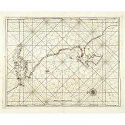
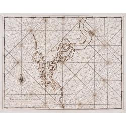
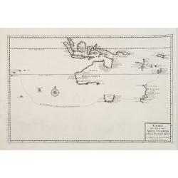
No title: Baya de Saldanha/ Cabo de Boa Esperanca.
Chart of the coast from Saldanha Bay to False Bay, the edge of the land rolled back to show the coast line in silhouette with a scale of miles and compass-rose. Marks Das...
Date: Amsterdam 1726
Selling price: ????
Please login to see price!
Sold
De Stad Malacka.
"Decorative panoramic view of the town of Malacca with European vessels in the foreground. The old Church of St. Paul's on the hill in the fortified old town to the ...
Date: Amsterdam 1726
Selling price: ????
Please login to see price!
Sold
Het eyland Neira, en het Casteel Nassau mitgaders Belgica.
"Decorative panoramic view of the island of Neira with European vessels in the foreground. The island belongs to the Banda islands.Françcois Valentijn (1666-1727), ...
Date: Amsterdam 1726
Selling price: ????
Please login to see price!
Sold
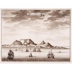
Geziet van Kaap der Goede Hope als men op de Reede legt.
Decorative panoramic view of the Cape of Good Hope with European vessels in the foreground.François Valentijn (1666-1727), a missionary, worked at Amboina from 1684 to 1...
Date: Amsterdam 1726
Selling price: ????
Please login to see price!
Sold
Batavia in 't verschiet.
Decorative panoramic view of Batavia, present-day Jakarta with European vessels in the foreground.Françcois Valentijn (1666-1727), a missionary, worked at Amboina from 1...
Date: Amsterdam 1726
Selling price: ????
Please login to see price!
Sold
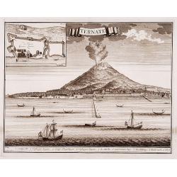
Ternate.
"Decorative panoramic view of Ternate with European vessels in the foreground. In upper left corner inset plan of the Fortress Oranje.Françcois Valentijn ...
Date: Amsterdam 1726
Selling price: ????
Please login to see price!
Sold
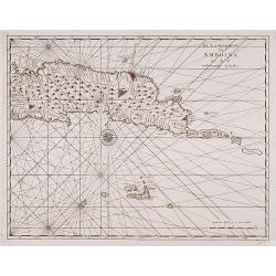
Amboina.
"Decorative panoramic view of the island of Amboina with European vessels in the foreground.Françcois Valentijn (1666-1727), a missionary, worked at Amboi...
Date: Amsterdam 1726
Selling price: ????
Please login to see price!
Sold
De Rivier van Suratta.
"Decorative map of the river Soeratta north of Bombay.Françcois Valentijn (1666-1727), a missionary, worked at Amboina from 1684 to 1694 and 1705 to 1713 ...
Date: Amsterdam 1726
Selling price: ????
Please login to see price!
Sold
![Boero and Amblauw. [no title]](/uploads/cache/15927-250x250.jpg)
Boero and Amblauw. [no title]
"Decorative map of the islands of Boero and Amblauw.Françcois Valentijn (1666-1727), a missionary, worked at Amboina from 1684 to 1694 and 1705 to 1713 an...
Date: Amsterdam 1726
Selling price: ????
Please login to see price!
Sold
![Malabar pars.. [no title]](/uploads/cache/15928-250x250.jpg)
Malabar pars.. [no title]
"Decorative map of the southern tip of the islands of Malabar.Françcois Valentijn (1666-1727), a missionary, worked at Amboina from 1684 to 1694 and 1705 ...
Date: Amsterdam 1726
Selling price: ????
Please login to see price!
Sold
De landvoogdy van Amboina met de elf onderhoorige Eylanden.
"Decorative map of the eastern tip of the islands of Amboina.Françcois Valentijn (1666-1727), a missionary, worked at Amboina from 1684 to 1694 and 1705 t...
Date: Amsterdam 1726
Selling price: ????
Please login to see price!
Sold
![Western part of the island Amboina with Boero. [no title]](/uploads/cache/15930-250x250.jpg)
Western part of the island Amboina with Boero. [no title]
"Decorative map of the western tip of the islands of Amboina.Françcois Valentijn (1666-1727), a missionary, worked at Amboina from 1684 to 1694 and 1705 t...
Date: Amsterdam 1726
Selling price: ????
Please login to see price!
Sold
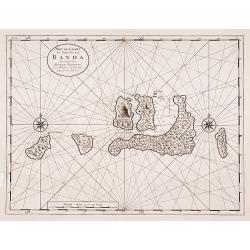
Nieuwe Caart der Eylanden van Banda.
"Decorative map of the Banda Islands.Françcois Valentijn (1666-1727), a missionary, worked at Amboina from 1684 to 1694 and 1705 to 1713 and travelled ext...
Date: Amsterdam 1726
Selling price: ????
Please login to see price!
Sold
![Cape of Good Hope [no title]](/uploads/cache/15932-250x250.jpg)
Cape of Good Hope [no title]
"Plan of Cape of Good Hope with the Dutch settlements.Françcois Valentijn (1666-1727), a missionary, worked at Amboina from 1684 to 1694 and 1705 to 1713 and travel...
Date: Amsterdam 1726
Selling price: ????
Please login to see price!
Sold
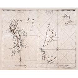
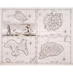
Het Eyland Sangir. / De Talautse Eylanden.
To the left map of the island of Sangir. To the right map of Talautse Islands.François Valentijn (1666-1727), a missionary, worked at Amboina from 1684 to 1694 and 1705 ...
Date: Amsterdam 1726
Selling price: ????
Please login to see price!
Sold
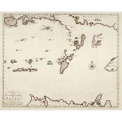
Kaart van de Zuyd-Ooster Eylanden van Banda.
"Map of the Banda islands. In the lower part of the map early out lines of Australia with van Diemens Land.Françcois Valentijn (1666-1727), a missionary, ...
Date: Amsterdam 1726
Selling price: ????
Please login to see price!
Sold
Kaart van de Zuyd-Wester Eylanden van Banda.
"Map of the Banda islands.Françcois Valentijn (1666-1727), a missionary, worked at Amboina from 1684 to 1694 and 1705 to 1713 and travelled extensively in...
Date: Amsterdam 1726
Selling price: ????
Please login to see price!
Sold
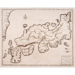
Nieuwe kaart van het Eyland Japan..
"The map originally appeared in Valentijn's book ""Oud en Nieuw Oost-Indien"" (Dordrecht/Amsterdam 1724/26). With in the right bottom corner the ...
Date: Amsterdam 1726
Selling price: ????
Please login to see price!
Sold
Caart van het Eyland Manipa../ Noessa-Laoet/ Honimoa/ Oma.
"Four maps on one sheet.Françcois Valentijn (1666-1727), a missionary, worked at Amboina from 1684 to 1694 and 1705 to 1713 and travelled extensively in t...
Date: Amsterdam 1726
Selling price: ????
Please login to see price!
Sold
Kaart der Reyse van Abel Tasman volgens syn eygen opstel..
Rare and important map from Vol III, 2 of Valentyn's Oud en Nieuw Oost Indien [1726] detailing the discoveries of Abel Tasman in Australasia during the course of his two ...
Date: Amsterdam 1726
Selling price: ????
Please login to see price!
Sold
Kaart van de Zuyd-Ooster Eylanden van Banda.
Map of the Banda islands. In the lower part of the map early out lines of Australia with van Diemens Land.François Valentijn (1666-1727), a missionary, worked at Amboina...
Date: Amsterdam 1726
Selling price: ????
Please login to see price!
Sold
Kaart der Reyse van Abel Tasman volgens syn eygen opstel..
Rare and important map from Vol III, 2 of Valentyn's Oud en Nieuw Oost Indien [1726] detailing the discoveries of Abel Tasman in Australasia during the course of his two ...
Date: Amsterdam 1726
Selling price: ????
Please login to see price!
Sold
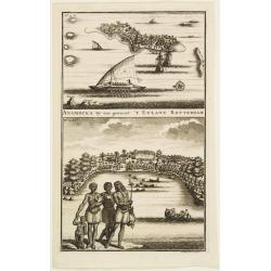
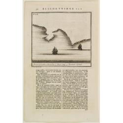
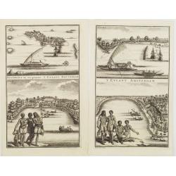
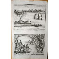
ANAMOCKA By ons genaent 'T EYLANT ROTTERDAM.
2 views on the Salomon Islands on one plate. The scenes illustrate indigenous people on the foreground while the European are represented on the background, discharging b...
Date: Amsterdam 1726
Selling price: ????
Please login to see price!
Sold
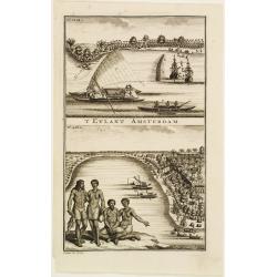
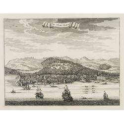
'T EYLANT AMSTERDAM.
2 views on the Salomon Islands on one plate. The scenes illustrate indigenous people on the foreground while the European are represented on the background, discharging b...
Date: Amsterdam 1726
Selling price: ????
Please login to see price!
Sold
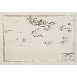
'T EYLANT AMSTERDAM.
Map of the southeastern coast of Tasmania (150x162), centered on Storm bay which was bound to become Hobart's harbor. 4 sites are identified through a key index on the bo...
Date: Amsterdam 1726
Selling price: ????
Please login to see price!
Sold
De Eliphants-Jagt gedaan in't Jaar 1717 inde Alutcoer Corle..
A informative print showing a place where elephants are kept and trained. Engraved by J.C.Philips.François Valentijn (1666-1727), a missionary, worked at Amboina from 16...
Date: Amsterdam 1726
Selling price: ????
Please login to see price!
Sold
1)'T Eylant Amsterdam. 2) Anamocka.. 't Eylant Rotterdam.
2 sheets featuring 2 views on the Salomon Islands on one plate. The scenes illustrate indigenous people on the foreground while the European are represented on the backgr...
Date: Amsterdam, 1726
Selling price: ????
Please login to see price!
Sold in 2008
![Eauweck. Hoofdstad van Cambodia. [Lawec]](/uploads/cache/25002-250x250.jpg)
Eauweck. Hoofdstad van Cambodia. [Lawec]
Decorative panoramic view of the town of Lawec in Cambodia. The city of shown in the centre of this illustration and is surrounded by hills, forests and a river.François...
Date: Amsterdam, 1726
Selling price: ????
Please login to see price!
Sold
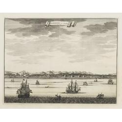
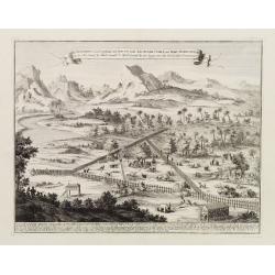
Samboepo in 't Verschiet.
Decorative panoramic view of the town of Samboupo on the island of Celebes (Sulawesi) in today's Indonesia. Dutch (V.O.C.) sailing ships and various local craft fill the ...
Date: Amsterdam, 1726
Selling price: ????
Please login to see price!
Sold
Samboepo in platte Grond.
Decorative panoramic view of the town of Samboupo on the island of Celebes (Sulawesi) in today's Indonesia. Dutch (V.O.C.) sailing ships and various local craft fill the ...
Date: Amsterdam, 1726
Selling price: ????
Please login to see price!
Sold in 2009
De stadt Dabul.
Decorative panoramic view of the town of Dabul. Dutch (V.O.C.) sailing ships and various local craft fill the foreground. The city with great detail including the fort an...
Date: Amsterdam, 1726
Selling price: ????
Please login to see price!
Sold
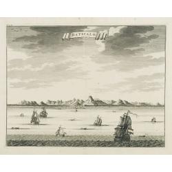
Baticalo.
Decorative panoramic view of the town of Baticalo on Ceylon. Dutch (V.O.C.) sailing ships and various local craft fill the foreground. The city with great detail includin...
Date: Amsterdam, 1726
Selling price: ????
Please login to see price!
Sold
\'T Eylant Amsterdam (Solomon Islands).
Engravings showing the native boats and peoples of Amsterdam Island, probably today one of the Solomon's Islands near Indonesia. François Valentijn (1666-1727), a missio...
Date: Dordrecht, 1726
Selling price: ????
Please login to see price!
Sold in 2008
Nieuwe Kaart van Caap de Goede Hoop in hare rechte jegenwoordige staat...
Two maps of Cape of Good Hope. . Windmills and churches are indicated on the bottom map. With inset identifying the first farm layouts, and who the farms belonged to, i...
Date: Amsterdam, 1726
Selling price: ????
Please login to see price!
Sold in 2008
![Comitatus Zelandiae Novissima Delineatio Per... Nun[c] Apud Pet. Schenck Jun.](/uploads/cache/91535-250x250.jpg)
Comitatus Zelandiae Novissima Delineatio Per... Nun[c] Apud Pet. Schenck Jun.
Detailed chart of islands in south west Netherlands with details shown pictorially.
Date: Amsterdam, 1726
Selling price: ????
Please login to see price!
Sold in 2010
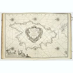
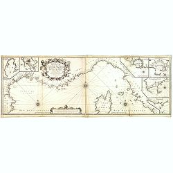
(Recueil de plans et ports de la Méditerranée).
Superb atlas of the Mediterranean containing 19 charts (including 1 double) engraved by Starckman, Coélemans, and B. Randon Hunting and mounted on heavy paper. Each char...
Date: Marseille, Laurent Brémond,1715-1726
Selling price: ????
Please login to see price!
Sold
De stad Bantam.
Decorative of the town of Bantam. In lower margin key a-z to the principal places in town.François Valentijn (1666-1727), a missionary, worked at Amboina from 1684 to 1...
Date: Amsterdam, 1726
Selling price: ????
Please login to see price!
Sold in 2013
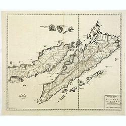
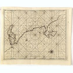
Nieuwe Kaart van het Eyland Sumatra..
Fine chart depicting the Island of Sumatra and the southern coasts of Malaysia from Quedo to Johore. North is orientated to the left of the page. Singapore is probably id...
Date: Amsterdam, 1726
Selling price: ????
Please login to see price!
Sold in 2011
Montalbaans Toren en Waterkeer.
Suberp view of the Montelbaanstoren in Amsterdam. Highly detailed print with buildings, people loading barrels, the watergate, and sailing ships.
Date: Amsterdam, 1726
Selling price: ????
Please login to see price!
Sold in 2012
Plan du Golfe de Naples et Des Environs. . .
Fine and rare chart of the Gulf of Naples and neighboring regions, including the Islands of Ischia, Capri and Procida. The chart has a large cartouche, and is adorned wit...
Date: Marseille, 1715-1726
Selling price: ????
Please login to see price!
Sold in 2014
Nouvelle Carte De Cotes De Catalogne, Rousiilon, Languedoc, Provence, D'Italie et Partie De L'Isle De Corce . . .
Striking two-sheet chart of the Mediterranean Coast, from Catalonia to the mouth of the Tiber River in Italy, showing most of Corsica and the island of Elba, with 6 large...
Date: Marseille, 1715-1726
Selling price: ????
Please login to see price!
Sold
Samboepo in platte Grond.
Decorative panoramic view of the town of Samboupo on the island of Celebes (Sulawesi) in today's Indonesia. Dutch (V.O.C.) sailing ships and various local craft fill the ...
Date: Amsterdam, 1726
Selling price: ????
Please login to see price!
Sold in 2015
Samboepo in 't Verschiet.
Decorative panoramic view of the town of Samboupo on the island of Celebes (Sulawesi) in today's Indonesia. Dutch (V.O.C.) sailing ships and various local craft fill the ...
Date: Amsterdam, 1726
Selling price: ????
Please login to see price!
Sold in 2016
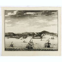
Cananor.
A view from the sea of the town of Cananoor on the Malabar coast. Dutch (V.O.C.) sailing ships and various local craft fill the foreground, the fortifications and buildin...
Date: Amsterdam, 1726
Selling price: ????
Please login to see price!
Sold in 2018
Kaart van de Zuyd-Ooster Eylanden van Banda.
Map of the Banda islands. In the lower part of the map early out lines of Australia with van Diemens Land.
Date: Amsterdam, 1726
Selling price: ????
Please login to see price!
Sold in 2015
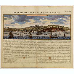
Description de la Ville de Smyrne.
This elegant view presents the Turkish city of Izmir from a vantage in the Gulf of Izmir. The city is shown in excellent detail before a mountainous backdrop, while numer...
Date: Amsterdam, 1726
Selling price: ????
Please login to see price!
Sold in 2015
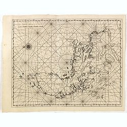
(Philippine Islands)
Oriented to the east. The northern Philippines, showing all of Luzon.François Valentijn (1666-1727), a missionary, worked at Amboina from 1684 to 1694 and 1705 to 1713 a...
Date: Amsterdam, 1726
Selling price: ????
Please login to see price!
Sold in 2015
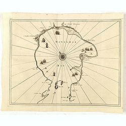
(Manilhas)
Untitled chart of Manila Bay [MANILHAS BAY] ... One of three maps and views of the Philippines published by François Valentijn (1666-1727), a missionary, who worked at A...
Date: Amsterdam, 1726
Selling price: ????
Please login to see price!
Sold in 2016
(Cabo de boa esperanca)
Chart of the Cape of Good Hope coast from Saldanha Bay to False Bay, the edge of the land rolled back to show the coast line in silhouette with a scale of miles and compa...
Date: Amsterdam, 1726
Selling price: ????
Please login to see price!
Sold in 2016
![Cape of Good Hope [no title]](/uploads/cache/35902-250x250.jpg)
Cape of Good Hope [no title]
Plan of Cape of Good Hope with the Dutch settlements. A lettered key in lower right corner.François Valentijn (1666-1727), a missionary, worked at Amboina from 1684 to 1...
Date: Amsterdam, 1726
Selling price: ????
Please login to see price!
Sold in 2015