Browse Listings
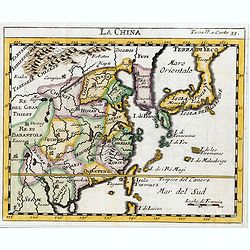
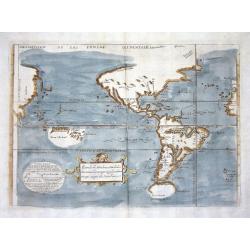
La Chine.
The map is of interest for the use of Sea of Japan / East Sea, the sea between Korea and Japan, here called "Mer Orientale".This small Italian map of China, Kor...
Date: Venice, c.1722
Selling price: ????
Please login to see price!
Sold in 2023
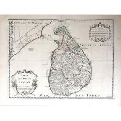
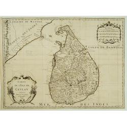
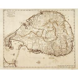
Carte de l'Isle de Ceylan.
A detailed map of Sri Lanka with soundings and two large title cartouches. Engraved by Charles Amadeus de Berey, an engraver active in Paris. Dated 1722 at the bottom of ...
Date: Paris, 1722
Selling price: ????
Please login to see price!
Sold in 2018
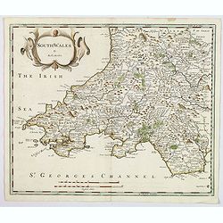
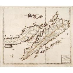
South wales.
A nice copper engraved map of South Wales, produced by Robert Morden for publication in Edmund Gibson's translation of William Camden's "Britannia", first publi...
Date: London, 1722
Selling price: ????
Please login to see price!
Sold in 2021

Mustapha I. Türckischer käyser.
Portrait engraving of Mustapha I. or Mustafa I (1591-1639), Ottoman sultan (1617-1618, 1622-1623), brother and successor of Ahmed I to the throne of the Ottoman Empire (T...
Date: Leipzig, 1721/1722
Selling price: ????
Please login to see price!
Sold in 2017
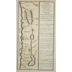
Plan et distribution de la terre de Chanaan.
Map of the tribes of Israel, with French text.
Date: Paris 1722
Selling price: ????
Please login to see price!
Sold
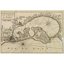
CARTAGENE Avec ses Ports et ses FORTS.
Decorative map of Cartagena, fortified colonial harbour in Colombia.
Date: Amsterdam 1722
Selling price: ????
Please login to see price!
Sold
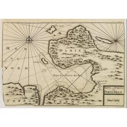
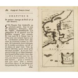
BAYE et FORTS de PORTO BELO.
Decorative map of the Portobelo Bay, in the region of Darien, Panama.From Voyages de François Coreal aux Indes Occidentales, Contenant ce qu'il y a vû de plus remarquab...
Date: Amsterdam 1722
Selling price: ????
Please login to see price!
Sold
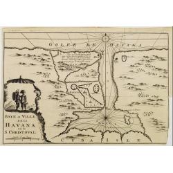
Baye et Ville de La HAVANA ou de S. CHRISTOVAL.
Attractive map centred on the town Havana and its large bay.
Date: Amsterdam 1722
Selling price: ????
Please login to see price!
Sold
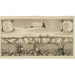
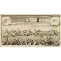
S. SALVADOR.
Charming view of Salvador de Bahia, in Brazil, seen from the ocean. With ribbon style title cartouche and 2 cartouches containing a key list. Decorated with 4 European ve...
Date: Amsterdam 1722
Selling price: ????
Please login to see price!
Sold
Entrée de Rio Janeiro.
Fine view of the entrance of Baía de Guanabara, in Rio de Janeiro.From Voyages de François Coreal aux Indes Occidentales, Contenant ce qu'il y a vû de plus remarquable...
Date: Amsterdam 1722
Selling price: ????
Please login to see price!
Sold
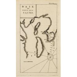
BAIE de Tous Les SAINS.
Fine view of Baía de Todos os Santos, in Bahia. With the town of Salvador outlined at the entrance of the bay.From Voyages de François Coreal aux Indes Occidentales, Co...
Date: Amsterdam 1722
Selling price: ????
Please login to see price!
Sold
S. SEBASTIEN.
Charming view of São Sebastião de Rio de Janeiro, taken from the ocean. With ribbon style title cartouche and 2 cartouches containing a lettered key list (A-G). Decorat...
Date: Amsterdam 1722
Selling price: ????
Please login to see price!
Sold
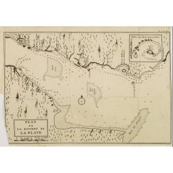
PLAN de la Riviere de la PLATE.
Appealing map focusing on the River de la Plata. With inset plan of "Baye des Maldonades", in Uruguay.From Voyages de François Coreal aux Indes Occidentales, C...
Date: Amsterdam 1722
Selling price: ????
Please login to see price!
Sold
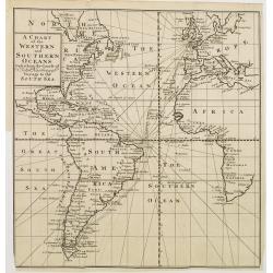
A Chart of the Western and Southern Oceans.
Copper engraved chart of the Atlantic showing the eastern part of North America, all of South America, and most of Europe and Africa. The tract of the voyage of John Narb...
Date: Amsterdam 1722
Selling price: ????
Please login to see price!
Sold
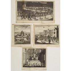
(Lot of 4 prints relating to Mexico.)
Lot of 4 prints illustrating the traditional rites and events concerning the native people of Mexico.From the book "Nouvelle Relation, Contenant LES VOYAGES DE THOMA...
Date: Amsterdam, 1722
Selling price: ????
Please login to see price!
Sold in 2020
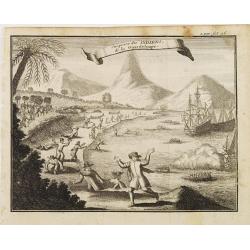
Surprise des INDIENS de la Guardeloupe..
Interesting print depicting the arrival of Europeans in Guadeloupe.From the book Nouvelle Relation, Contenant LES VOYAGES DE THOMAS GAGE dans la nouvelle Espagne [..] jus...
Date: Amsterdam 1722
Selling price: ????
Please login to see price!
Sold
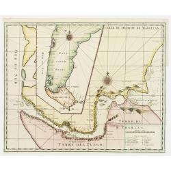
Carte du Dêtroit de Magellan.
Detailed map of Strait Magellan. With a key lower right stating the different smaller islands in the strait.Relief shown pictorially. Decorated with 2 large compass roses...
Date: Amsterdam 1722
Selling price: ????
Please login to see price!
Sold
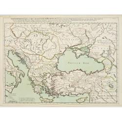
Imperii Orientalis Circumjacenttium..Constantiono..
Including Greece, Cyprus, Ukraine, Moldavia and the Black Sea.
Date: Paris, 1722
Selling price: ????
Please login to see price!
Sold in 2008
![Carte Marine De La Mer Caspiene.. [Set of two maps.]](/uploads/cache/02934-250x250.jpg)
Carte Marine De La Mer Caspiene.. [Set of two maps.]
Detailed of the Caspian Sea, prepared by Karl van Verden in 1722. Van Verden was a Russian sailor who produced the first accurate map of Caspian. With 8 inset maps.
Date: Paris, 1722
Selling price: ????
Please login to see price!
Sold in 2009
![La Ville de Mexique. [together with ] Environs du. . .](/uploads/cache/22545-250x250.jpg)
La Ville de Mexique. [together with ] Environs du. . .
Lot of two views of Mexico City. From "Voyages de François Coreal aux Indes Occidentales, Contenant ce qu'il y a vû de plus remarquable pendant son séjour depuis ...
Date: Amsterdam, 1722
Selling price: ????
Please login to see price!
Sold in 2008
Carte de la Souverainete de Neuchatel et Vallangin. . .
De L'Isle maps were almost always issued with outline color, and it is very unusual to find them in such rich was color.Detailed map prepared by David Francois de Merveil...
Date: Paris, 1722
Selling price: ????
Please login to see price!
Sold in 2011
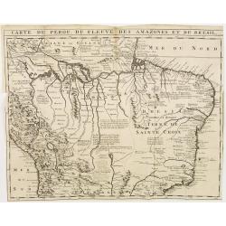
Carte du Perou, du Fleuve des Amazones et du Bresil.
Appealing map focusing on the Amazon Basin, therefore including large part of the Brazilian Peruvian and Bolivian territories. Relief shown pictorially.From "Voyages...
Date: Amsterdam, 1722
Selling price: ????
Please login to see price!
Sold in 2010
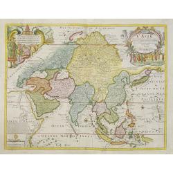
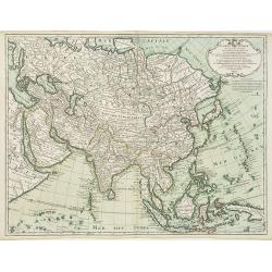
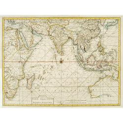
L'Asie dressée selon les dernières relations et suivant les nouvelles découvertes dont les points principaux. . .
Showing the land masses from Arabia to Japon ou I.de Niphon and Nouvelle Zeelande (but what is part of New Guinea). Decorative dedication panel and title cartouche.
Date: Paris, 1722
Selling price: ????
Please login to see price!
Sold in 2011
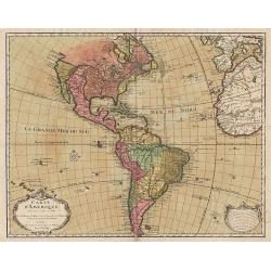
Carte d'Amerique.
This is a typically fine map by Guillaume de l'Isle, here with the address Sur le Quay d'Horloge, dated 1722.Early second state. The west coast of North America is deline...
Date: Paris, 1722
Selling price: ????
Please login to see price!
Sold in 2012
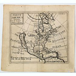
North America According to the Latest Observations.
State 1 with north latitude 60 deg. above the Arctic Circle. First issued in: Geography Anatomiz'd... The ninth edition. . . and a set of new maps by Mr. Senex / Patrick ...
Date: London, ca 1722
Selling price: ????
Please login to see price!
Sold in 2023
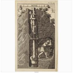
Mine.
Interesting print illustrating the entrance of a mine and part of a tunnel. It was mend to describe the hard labour to which the native Peruvian were forced.From "Vo...
Date: Amsterdam, 1722
Selling price: ????
Please login to see price!
Sold in 2020
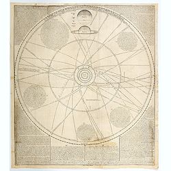
A Scheme of the Solar System with the Orbits of the Planets and Comets belonging thereto, Describ'd from Dr. Halley's accurate Table of Comets. . .
This wonderful broadside highlights the very latest discoveries and theories of planetary revolution, based upon the works of the English astronomers Sir Isaac Newton, an...
Date: London, 1722
Selling price: ????
Please login to see price!
Sold in 2020
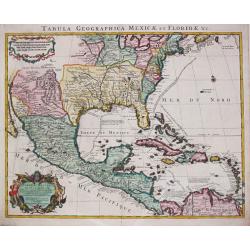
Tabula Geographica Mexicae et Floride des Terres Angloises et des Isles Antilles, du Cours et des Environs de la Riviere de Mississipi. Par G. de l' Isle a Amsterdam chéz Jean Covens & Corneille Mortier. 1722.
Guillaume de l' Isle (1675-1724), Royal Geographer, was the most influential cartographer of the first quarter of the 18th century. ' Atlas de Géographie' (1700-12), pos...
Date: Amsterdam, 1722
Selling price: ????
Please login to see price!
Sold in 2022
Accurates lankärtlein worine...Belgrad
Rare map, centered on Belgrade. With a lettered key, probably referring to the siege of Belgrade of 1717.
Date: Augsburg, ca.1722
Selling price: ????
Please login to see price!
Sold in 2023
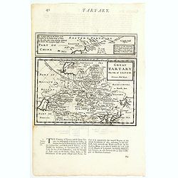
Great Tartary, The Isle of Japan.
A nice copper engraved map of Northern Asia and Japan. It extends from the Caspian Sea and "Part of Moscovy or Russia" in the west to China in the east, northwa...
Date: London, ca 1723
Selling price: ????
Please login to see price!
Sold in 2021
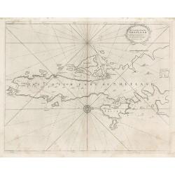
The South Part of Shetland
This decorative copperplate nautical chart was part of the work commissioned by Charles II of England when Samuel Pepys was Secretary to the Admiralty. The work was to ch...
Date: London, 1723
Selling price: ????
Please login to see price!
Sold in 2023
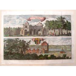
Rudera Sive Reliquia Templi et Monesteri Alfvastrae / Braaborg.
View of the ruins of the 12th century Cistercian monastery at Alvastra. Also, view of the palace at Braaborg. From Dahlbergh's "Suecia Aniqua et Hodierna". Feat...
Date: Stockholm, 1723
Selling price: ????
Please login to see price!
Sold in 2013
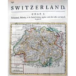
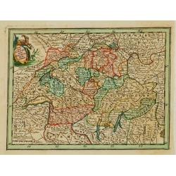
A map of Switzerland.
Uncommon map which we could not identify. Published probably in London in the early 18th century. Subtitled "Switzerland, Helvetia, or the Swiss-Cantons, together wi...
Date: London, c. 1723
Selling price: ????
Please login to see price!
Sold in 2013
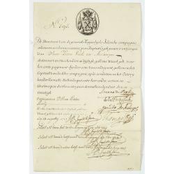
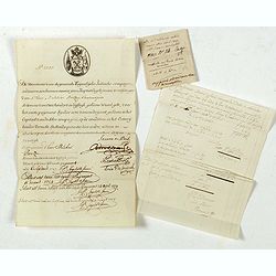
Very rare share in the Ostend Company. N° 595
The upper left-hand corner had the share number 595 in manuscript. In the top the emblem of the Company in copper engraving. Text: "De Directeurs van de generale...
Date: Antwerp / Ostend 1723
Selling price: ????
Please login to see price!
Sold
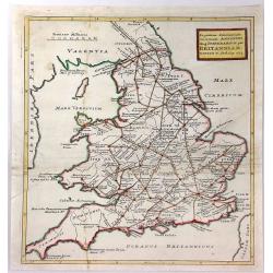
Ingratiam Itinerantium Curiosorum Antonini Aug. Itinerarium per Britanniam ...
A general map of Britain, featuring the Roman live and main cross-roads in England and Wales. Published in the “Itinerarium Curiosum” by William Stukeley, An original...
Date: London, 1723
Selling price: ????
Please login to see price!
Sold in 2016
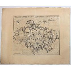
Plan de la Ville et Citadelle de Valenciennes.
Beautiful engraved plan showing the city and the citadel of Valenciennes, drawn in 1709 by Eugène Henry Fricx, a Brussels printer specialized in battles and sieges. Nice...
Date: Amsterdam, 1723
Selling price: ????
Please login to see price!
Sold in 2019
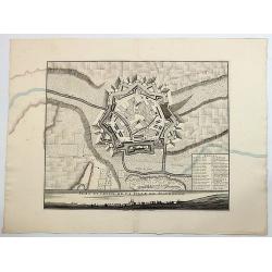
Plan et Profil de la Ville de Maubeuge.
Beautiful engraved plan showing the city of Maubeuge, drawn by Eugène Henry Fricx, a Brussels printer specialized in battles and sieges. Nice copy with large margins. Th...
Date: Amsterdam, 1723
Selling price: ????
Please login to see price!
Sold in 2017
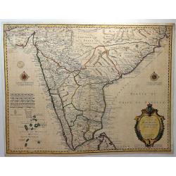
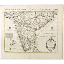
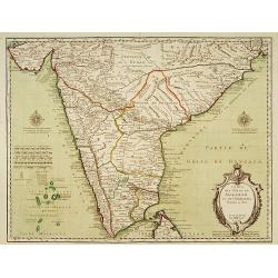
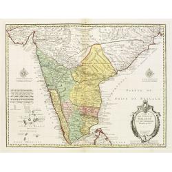
Carte des Cotes de Malabar et de Coromandel.
A striking map of southern India and Northern Ceylon, that extends to the Maldive Islands, and the northern tip of Sri Lanka. Cities, trade routes and topography are deta...
Date: Paris, 1723
Selling price: ????
Please login to see price!
Sold in 2018
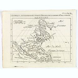
L'Amérique Septentrionale suivant Mr. Delisle de l'Académie Royale des Sciences.
A copper engraving map of the North American continent from the atlas Science des personnes de la cour, a rare and richly illustrated handbook for aristocrats at the roya...
Date: Amsterdam, 1723
Selling price: ????
Please login to see price!
Sold in 2018
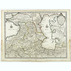
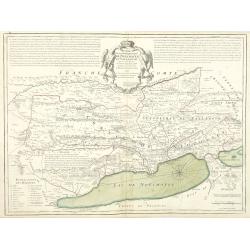
Carte des Pays Voisins de la Mer Caspiene dressee pour l' usage du Roy. . .
Detailed and attractive map focusing on Georgia, Azerbaijan and Armenia. With the imprint "Par Guillaume Delisle Premier Geograp. he du Roy, de l'Academie Royale. 15...
Date: Paris, 15 August 1723
Selling price: ????
Please login to see price!
Sold in 2018
Carte des Cotes de Malabar et de Coromandel..
Detailed and attractive map of India and the northern tip of Sri Lanka. Prepared by G. de l'Isle and published in Amsterdam. With decorative title cartouche and two compa...
Date: Amsterdam, 1723
Selling price: ????
Please login to see price!
Sold in 2020
Very rare share in the Ostend Company.
Upper left hand corner share number 2305 in manuscript. In top emblem of the Ostend Company in copper engraving. Text: De Directeurs van de generale Keijserlijche- Indisc...
Date: Antwerp / Ostend, 1723
Selling price: ????
Please login to see price!
Sold in 2025
L'Amerique Septentrionale suivant M. de Lisle de l'Academie Royaume des Sciences.
An attractive copper engraving map from the Science des personnes de la cour de l'Epee et de la Robe, a rare and richly illustrated handbook for aristocrats at the French...
Date: Amsterdam, 1723
Selling price: ????
Please login to see price!
Sold in 2020
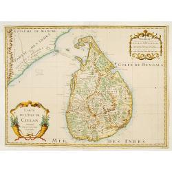
Carte de l'Isle de Ceylan..
Detailed map of Sri Lanka with soundings and two large title cartouches. Engraved by Charles Amadeus de Berey, an engraver active in Paris. Dated 1700.
Date: Paris 1723
Selling price: ????
Please login to see price!
Sold
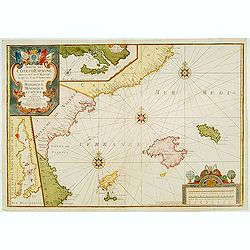
Suitte des Cotes d'Espagne.. avec les Isles de Mayorque Minorque et d'Yvice.
An attractive map centred on the eastern part of Spain. Includes two inset maps of Minorca and Sofa Bay. Decorative title cartouche on the upper left corner. With the men...
Date: France 1723
Selling price: ????
Please login to see price!
Sold
Carte de l'Isle de Ceylan..
Engraved by Charles Amadeus de Berey, an engraver active in Paris. Detailed map of Shri Lanka with soundings and two large title cartouches.
Date: Paris 1723
Selling price: ????
Please login to see price!
Sold
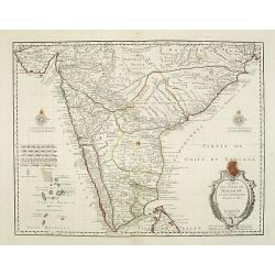
Carte des Cotes de Malabar et de Coromandel..
Detailed and attractive map of India and the northern tip of Sri Lanka. With decorative title cartouche and two compass-roses.
Date: Paris, 1723
Selling price: ????
Please login to see price!
Sold in 2011
Descripcion de las Yndias Ocidentales
Rare Spanish map of the Pacific and Americas. As usual Spain tried to limit the exploit of their geographical knowledge through piracy and therefore only allowed limited ...
Date: Madrid, c.1723
Selling price: ????
Please login to see price!
Sold
Carte des Cotes de Malabar et de Coromandel..
An early issue of this detailed and attractive map of India and the northern tip of Sri Lanka. With decorative title cartouche and two compass-roses.Engraved by Marin.
Date: Paris 1723
Selling price: ????
Please login to see price!
Sold

Ceremonie nuptiale du Canada / Maniere dont les peuples du canada font le divorce.
Two prints on one page depicting wedding and divorce customs in Canada.
Date: Amsterdam, 1723
Selling price: ????
Please login to see price!
Sold in 2011

Rejouïssances des peuples du Canada, pendant que l'on porte le défunt ... / Convoi funêbre ...
Two prints on one page depicting funeral customs and celebrations in Canada.
Date: Amsterdam, 1723
Selling price: ????
Please login to see price!
Sold in 2011
Carte des Cotes de Malabar et de Coromandel. . .
Detailed and attractive map of India and the northern tip of Sri Lanka. With decorative title cartouche and two compass-roses. Engraved by Martin.Interestingly; during th...
Date: Paris, 1723
Selling price: ????
Please login to see price!
Sold in 2015
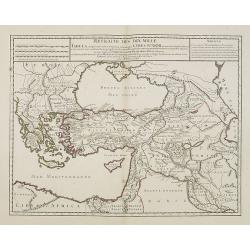
Retraite des Dix Mille Tabula conspectum exhibens Regionum omnium quas Cyrus Junior, Artaxerxi fratibellum illaturus ac Cyro in acie caeso. . .
Depicting ancient Turkey and Greece, including Cyprus, Black Sea, Iraq and Persia.
Date: Paris, 1723
Selling price: ????
Please login to see price!
Sold in 2008
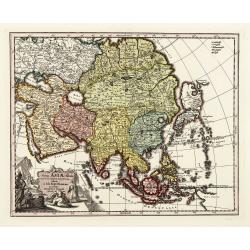
Carte d'Asie, dressée sur les Memoires envoyéz par le Czar. . .
The important 1723 map of Asia by G.de L'Isle. The map is of interest for the use of East Sea, the sea between Korea and Japan, here called "Mer de Corée". Wit...
Date: Paris, 1723
Selling price: ????
Please login to see price!
Sold in 2010
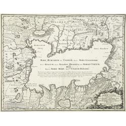
Novissima et accurata Maris Caspij Fere nobis incogniti Regionumque adiacentium delineatio Iussu PETRI ALEXIJ FIL magni Russorum principis. . .
An uncommon issue of this important and detailed map of the Caspian Sea and countries bordering it, showing settlements and topography and providing soundings around the ...
Date: Rome, Domenico de Rossi, 1723
Selling price: ????
Please login to see price!
Sold in 2010

La Perse La Georgie, La Natolie Les Arabies..
Rare map of the Arabian Peninsular, Turkey, Persia. Prepared by Nicolas de Fer, issued by G.Danet.
Date: Paris 1724
Selling price: ????
Please login to see price!
Sold
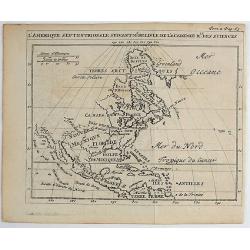
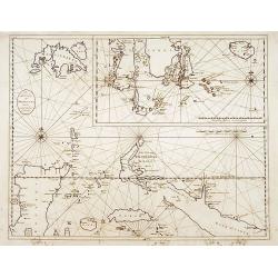
Nieuwe Kaart van het Eyland Sumatra..
Fine chart depicting the Island of Sumatra and the southern coasts of Malaysia from Quedo to Johore. North is orientated to the left of the page. Singapore is probably id...
Date: Amsterdam 1724
Selling price: ????
Please login to see price!
Sold
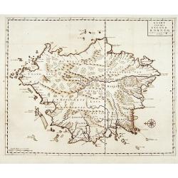
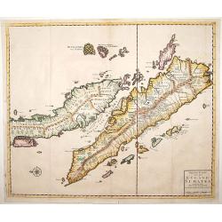
Nieuwe Kaart van het Eyland Ceylon opgestelt door..
Fine chart depicting the Island of Ceylon/Sri Lanka.Good interior detail is given with settlements, roads, etc. An attractive early map, one of the few early very detaile...
Date: Amsterdam 1724
Selling price: ????
Please login to see price!
Sold
![[Manilhas Bay]](/uploads/cache/15798-250x250.jpg)
[Manilhas Bay]
Fine chart depicting Manilla Bay. Little interior detail is given but the coastlines, settlements and principal coastal features are identified. An attractive early chart...
Date: Amsterdam 1724
Selling price: ????
Please login to see price!
Sold
![No title [Persia]](/uploads/cache/15799-250x250.jpg)
No title [Persia]
Fine map centered on Persia, including Caspian Sea, northern part of the Arabian Peninsular, etc.
Date: Amsterdam 1724
Selling price: ????
Please login to see price!
Sold
Kaart van het eyland Borneo.
Fine chart depicting the Island of Borneo. North is orientated to the left of the page.Little interior detail is given but the coastlines, settlements and principal coast...
Date: Amsterdam 1724
Selling price: ????
Please login to see price!
Sold
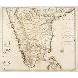
Nieuwe Kaart van Choromandel ende Malabar..
"Fine chart depicting the southern part of India and the northern tip of Ceylon. Much detail is given along the coastlines, settlements and principal coastal feature...
Date: Amsterdam 1724
Selling price: ????
Please login to see price!
Sold
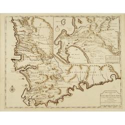
Nieuwe Kaart van Caap der Goede Hoop..
"Fine chart depicting the southern tip of Africa. Little interior detail is given but the coastlines, settlements and principal coastal features are identified. An a...
Date: Amsterdam 1724
Selling price: ????
Please login to see price!
Sold
![[Lucon of Luconia]](/uploads/cache/15797-250x250.jpg)
[Lucon of Luconia]
Fine chart depicting the Islands of the Philippines. Little interior detail is given but the coastlines, settlements and principal coastal features are identified. An att...
Date: Amsterdam 1724
Selling price: ????
Please login to see price!
Sold
De Landvoogdy der Moluccos..
"Fine chart depicting the Moluccas islands. Little interior detail is given but the coastlines, settlements and principal coastal features are identified. To the low...
Date: Amsterdam 1724
Selling price: ????
Please login to see price!
Sold
![[Title page] Nouveau Theatre d'Italie.](/uploads/cache/13925-250x250.jpg)
[Title page] Nouveau Theatre d'Italie.
A beautifully engraved and richly decorated title page from the town book of Italy, including a view of Venice in the lower corner.This title page is particularly rare as...
Date: Amsterdam, 1724
Selling price: ????
Please login to see price!
Sold in 2011
Tabula Indiae Orientalis et regnorum adjacentium.
The map originally appeared in Valentijn's book Oud en Nieuw Oost-Indien (Dordrecht/Amsterdam 1724/26). With in the right bottom corner the imprint J.van Braam en G. onde...
Date: Amsterdam 1724
Selling price: ????
Please login to see price!
Sold
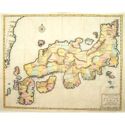
Nieuwe kaart van het eyland Japan.
The map originally appeared in Valentijn's book Oud en Nieuw Oost-Indien (Dordrecht/Amsterdam 1724/26). With in the right bottom corner the imprint J.van Braam en G. onde...
Date: Amsterdam 1724
Selling price: ????
Please login to see price!
Sold
Nieuwe Kaart van het Eyland Sumatra..
Fine chart depicting the Island of Sumatra and the southern coasts of Malaysia from Quedo to Johore. North is orientated to the left of the page. Singapore is probably id...
Date: Amsterdam 1724
Selling price: ????
Please login to see price!
Sold
Nova Asiae tabula e majori in minorem..
On this map Hokkaido is even bigger depicted than Honshu and connected to Japan's main island.
Date: Nurnberg, 1724
Selling price: ????
Please login to see price!
Sold in 2015
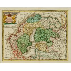
Sueciae Regnum cum vicinis Regionibus.
Uncommon map of Scandinavia. The originally colored title cartouche is surrounded by mythological figures. From Atlas Portatif.
Date: Nuremberg 1724
Selling price: ????
Please login to see price!
Sold
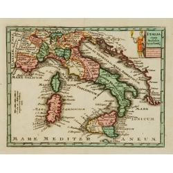
Italia cum Insulis..
Uncommon map of Italy. The originally colored title cartouche is surrounded by mythological figures. From Atlas Portatif.
Date: Nuremberg 1724
Selling price: ????
Please login to see price!
Sold
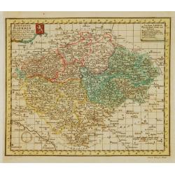
Königreich Boehmen mit seinen..
Uncommon map of Bohemia. The originally colored title cartouche has a coat-of-arms. From Atlas Portatif.
Date: Nuremberg 1724
Selling price: ????
Please login to see price!
Sold
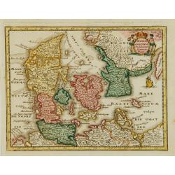
Daniae cum Serie Insularum?
Uncommon map of Denmark. The originally colored title cartouche is surrounded by mythological figures. From Atlas Portatif.
Date: Nuremberg 1724
Selling price: ????
Please login to see price!
Sold
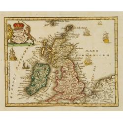
Angliae Scotiae et Hiberniae Regna..
Uncommon map of Great Britain and Ireland. The originally colored title cartouche is surrounded by mythological figures. From Atlas Portatif.
Date: Nuremberg 1724
Selling price: ????
Please login to see price!
Sold
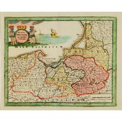
Regni Prussiae accurata delineatio.
Uncommon map of Prussia. The originally colored title cartouche is surrounded by mythological figures. From Atlas Portatif.
Date: Nuremberg 1724
Selling price: ????
Please login to see price!
Sold
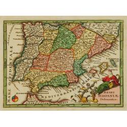
Regni Hispaniae Delineatio.
Uncommon map of Spain. The originally colored title cartouche is surrounded by mythological figures. From Atlas Portatif.
Date: Nuremberg 1724
Selling price: ????
Please login to see price!
Sold
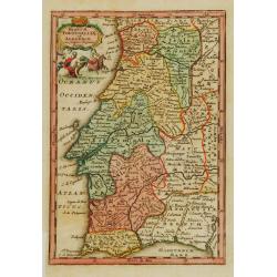
Regnum Portugalliae et Algarbiae..
Uncommon map of Portugal and Gibraltar. The originally colored title cartouche is surrounded by mythological figures. From Atlas Portatif.
Date: Nuremberg 1724
Selling price: ????
Please login to see price!
Sold
Novissima Foederatorum Helvetiorum Tabula.
Uncommon map of Switzerland. The originally colored title cartouche is surrounded by mythological figures. From Atlas Portatif.
Date: Nuremberg 1724
Selling price: ????
Please login to see price!
Sold
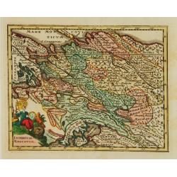
Imperium Moscoviae.
Uncommon map of Russia. The originally colored title cartouche is surrounded by mythological figures. From Atlas Portatif.
Date: Nuremberg 1724
Selling price: ????
Please login to see price!
Sold