Browse Listings
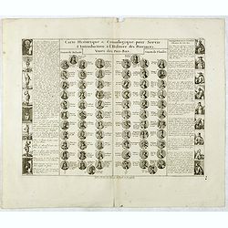
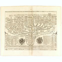
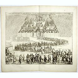
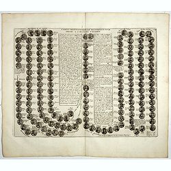
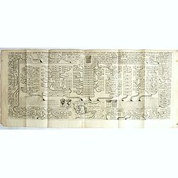
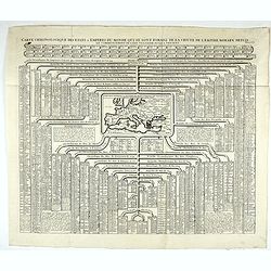
Carte Historique & Cronologique pour Servir d'Introduction a l'Histoire des Provinces Unies des Pays-Bas.
This folio sheet shows a genealogical chart and portraits of the rulers of Holland and Flanders with descriptive French text, from Chatelain's monumental 7 volume "A...
Date: Amsterdam, 1728
Selling price: ????
Please login to see price!
Sold in 2016
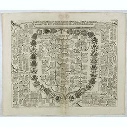
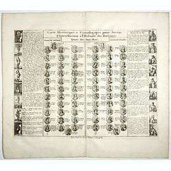
Carte Genealogique Des Maisons Imperialles Depuis Charles-Magne...
Fascinating genealogical tree, showing the lineage of Charlemagne through the modern era, including the ruling families of Astria, Spain, Suabe, Germany, Saxony, and Luxe...
Date: Amsterdam, 1728
Selling price: ????
Please login to see price!
Sold in 2016
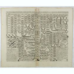
Carte genealogique pour conduire à faire connoître sur quoi sont fondés les pre tendants à la succession de la principauté de Neufchatel.
Genealogical tree with two maps "Principauté de Neuchatel" and "Baronie de Arley de la Maison de Chalons", with descriptive French text, from Chatela...
Date: Amsterdam, 1728
Selling price: ????
Please login to see price!
Sold in 2020
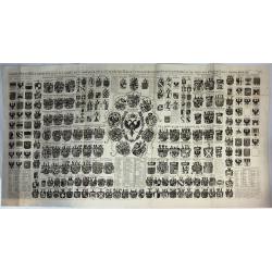
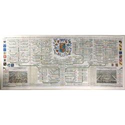
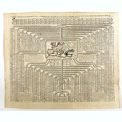
Carte Heraldique Representant Les Armes De L' Empereur Des Electeurs Des Princes Tant Ecclesiastiques Que Seculiers Et De Tous Les Etats Du Saint Empire Romain
A magnificent large copper engraved chart, illustrating the coats of arms of the Emperor, Electors and Princes of the Holy Roman Empire. At its centre is the fantastic ar...
Date: Amsterdam, 1728
Selling price: ????
Please login to see price!
Sold in 2018
Genealogie de la maison de Holstein, ses diferentes branches, ses titres, ses armes et ses aliances.
This handsome genealogical chart is a wonderful example of Chatelain’s elegant engravings. Included in the Atlas Historique, published by Chatelain in Amsterdam, this l...
Date: Amsterdam, 1728
Selling price: ????
Please login to see price!
Sold in 2016
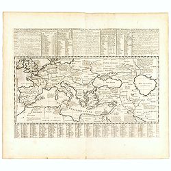
Carte historique chronologique et géographique de l'empire romain où l'on fait observer son étendue et diverses remarques pour l'intelligence de l'histoire.
Interesting sheet with a map of the Roman Empire, with descriptive French text, from Chatelain's monumental 7 volume Atlas Historique. In upper right margin: 'N°10'.Henr...
Date: Amsterdam, 1728
Selling price: ????
Please login to see price!
Sold in 2016
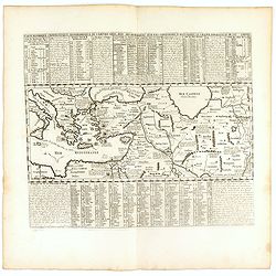
Carte historique chronologique et géographique de l'empire Grec . . .
Interesting sheet with a map of the Roman Empire, with descriptive French text, from Chatelain's monumental 7 volume Atlas Historique. In upper right margin: 'N°10'.Henr...
Date: Amsterdam, 1728
Selling price: ????
Please login to see price!
Sold in 2017
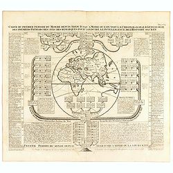
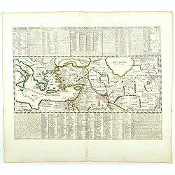
Carte du premier periode du Monde depuis Adam jusque' a Moise ou l'on voit la Chronologie & la genealogie des premeirs patriarches avec des remarques pour conduire a l' intelligence de l' Histoire sacree.
Fascinating engraving depicting a map of the Old World surrounded and keyed to a Biblical genealogical family tree. Panels at the side provide a historical timeline for t...
Date: Amsterdam, 1728
Selling price: ????
Please login to see price!
Sold in 2016
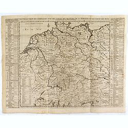
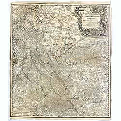
Nouvelle Carte de l'Alemagne avec des tables des branches de la noblesse...
Map of Germany including parts of the neighbouring countries with a key table to the towns on both sides.Zacharie Chatelain (d.1723) was the father of Henri Abraham (1684...
Date: Amsterdam, ca. 1728
Selling price: ????
Please login to see price!
Sold in 2021
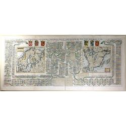
Carte Généalogique Pour Conduire à l'Histoire des Rois du Nord de la Carte de Leurs Etats, Leurs Armes et des Remarques Pour Conduire à l'Intelligence de l'Histoire du Nord
A very detailed, and wonderfully colored, composite sheet, with a genealogical table of the Kingdoms of the Scandinavian countries, with two small maps: Scandinavia and S...
Date: Amsterdam, 1728
Selling price: ????
Please login to see price!
Sold in 2016
Carte Genealogique de la Famille Royale de Brunswick, Lunebourg, Hanover & les Differentes Branches.
A very detailed, and beautifully colored, composite sheet with a genealogical table of the German royal families of Brunswick, Lunebourg and Hanover, with descriptive Fre...
Date: Paris, 1728
Selling price: ????
Please login to see price!
Sold in 2016
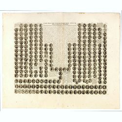
Carte historique et chronologique pour servir de suite a l histoire Romaine. . .
Extremely interesting sheet with a small portraits of the Roman Emperors.From: Atlas Historique.More about Chatelain Atlas. [+]
Date: Amsterdam, 1728
Selling price: ????
Please login to see price!
Sold in 2016
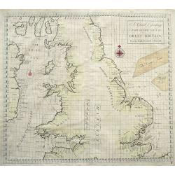
A Chart Describing part of the coast of Great-Britain, from the South Foreland to Berwick.
Very rare sea-chart of the coasts of England and Wales, including the Isle of Man, and the east coast of Ireland. With numerous place names and depth soundings. With two ...
Date: London, 1728
Selling price: ????
Please login to see price!
Sold in 2016
Nova et Accurata Ducatus Cliviae et Comitatus Marchiae.
Seutter's map of the German Duchies Jülich, Cleves, Berg with the County of Mark. With an elaborate -uncolored- title cartouche in upper right corner.
Date: Augsburg, 1728
Selling price: ????
Please login to see price!
Sold in 2016
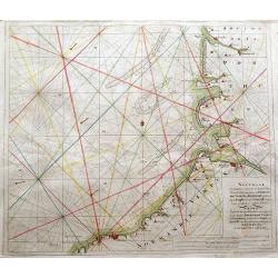
Nouvelle Cartemarine croissante...Normandie, Vimeux, et Ponthieu, entirant depuis Etaples...
A detailed copper-engraved sea chart of a part of Normandy, from Dieppe until Etaples.Locates a number of towns along the coast, including Montreuil, Berck, Rue, Saint-Va...
Date: Amsterdam, 1728
Selling price: ????
Please login to see price!
Sold in 2016
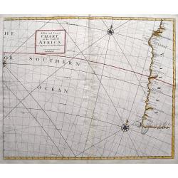
A New and Correct Chart of the Coast of Africa from Cape Negro to Cape Bona Esperance.
A rare sea chart showing a part of South Africa including the Cape of Good Hope and Table Bay. Extends to locate Tristan da Cunha and St. Helena! Published in the Atlas...
Date: London, 1728
Selling price: ????
Please login to see price!
Sold in 2016
Carte chronologique des etats et empires du monde, qui se sont former de la chute de l'empire romain, depuis le commencement de . . .? Vulgaire, jusqu'a present. . .
Extremely interesting sheet with a small map of the Roman Empire at center. Published by Henri Abraham Chatelain (1684 – 1743) who was a Huguenot pastor of Parisian ori...
Date: Amsterdam, 1728
Selling price: ????
Please login to see price!
Sold in 2020
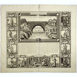
Habillemens d'hommes et de femmes de diverses provinces de la Chine avec un des plus beaux monumens de ce païs là.
In top a view of a bridge in Xensi Province bordered by eleven examples of Chinese dress from different provinces. Showing various people in their typical dress including...
Date: Amsterdam, 1728
Selling price: ????
Please login to see price!
Sold in 2023
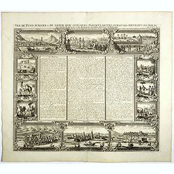
Vue de Tunis D Alger &c de Gigeri avec Quelques Particularitez Curieuses . . .
The plate is bordered by series of views with views and people of present-day Algeria. On top a view of Algiers, a funeral and how they executed criminals. On the bottom ...
Date: Amsterdam, 1728
Selling price: ????
Please login to see price!
Sold in 2017
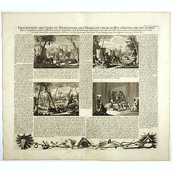
Description des cases ou habitations des negres, de celles du Roi d'Issiny . . .
Four engravings on one sheet showing native live in Africa, including warriors, a leopard, the manner of gathering food from palm trees and the interior of a typical nati...
Date: Amsterdam, ca. 1728
Selling price: ????
Please login to see price!
Sold in 2020
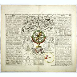
Premier Carte pour L'Introduction a L'Histoire du Monde ou L'on Remarque la Sphere le Globe Celeste, et les Differens Sistemes du Monde.
Original hand-colored plate showing in top an uncolored twin celestial hemisphere chart, armillary, sphere, a small double hemisphere terrestrial map showing the Island o...
Date: Amsterdam, 1728
Selling price: ????
Please login to see price!
Sold in 2017
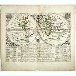
Map monde ou description generale du globe terrestre.
A double hemisphere world map, surrounded by a florid vine pattern with depictions of "Le Soleil Salon le Pere Kircher" and "La Lune Selon Monsieur Cassini...
Date: Amsterdam, 1728
Selling price: ????
Please login to see price!
Sold in 2022
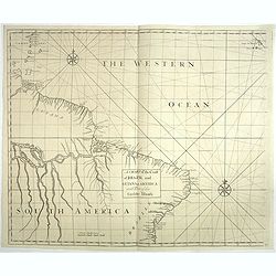
A chart of the coast of Brazil and Guiana in America with part of the Caribbe Islands.
This fine English chart of Brazil, Suriname and a few Caribbean Islands has two large compass roses in the Atlantic Ocean. From "Atlas Maritimus & Commercialis, ...
Date: London, 1728
Selling price: ????
Please login to see price!
Sold in 2017
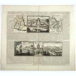
Description, situation et vue de la ville de Mexique des deux Lacs..Grand Temple..
This copper-engraving shows a map of Mexico, a map with the Lake of Mexico and area, also showing three panoramic views, one of the city Mexico, one of the large Temple o...
Date: Amsterdam, 1728
Selling price: ????
Please login to see price!
Sold in 2017
Carte du Gouvernement Civil et Politique de l'Espagne . . .
This impressive engraving provides a detailed description of the infrastructure of the Spanish government. Ornamented with numerous vignettes illustrating sessions of par...
Date: Amsterdam, 1728
Selling price: ????
Please login to see price!
Sold in 2021
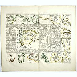
Carte d'Espagne et des Principaux Etats. . .
Interesting sheet showing 15 maps of Spain and it's overseas possessions. With maps of Philippines, Canary Islands, Sardinia, Cuba, Mexico, Belgium, Sicily and South Amer...
Date: Amsterdam, 1728
Selling price: ????
Please login to see price!
Sold in 2017
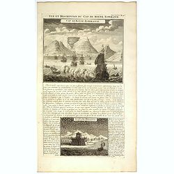
Vue et Description du Cap de Bonne Espérance.
In top copperplate engraving of the Cape with shipping in the foreground flying the Dutch flag, with engraved descriptive text between the two views, mainly concerning th...
Date: Amsterdam, 1728
Selling price: ????
Please login to see price!
Sold in 2017
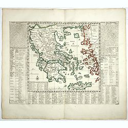
Carte historique et géographique de l'ancienne Grece . . .
A map of Greece during the Roman Empire, with descriptive French text, from Chatelain's monumental 7 volume Atlas Historique. In upper right margin: 'N°6.Henri Abraham C...
Date: Amsterdam, 1728
Selling price: ????
Please login to see price!
Sold in 2022
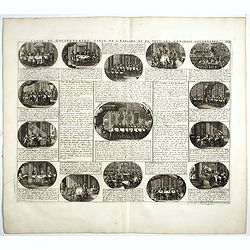
Carte pour donner une idée generale du gouvernement D'Ecosse . . .
Illustrating the activities and principal members of the Scottish Parliament. Remarkable detail, with over 30 individuals and groups named.Henri Abraham Chatelain (1684 �...
Date: Amsterdam, 1728
Selling price: ????
Please login to see price!
Sold in 2019
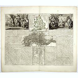
Nouvelle carte du gouvernement civil D'Angleterre et de celuy de la ville de Londres.
Striking plan of London, with map of England and two large allegorical figures of Liberty, Justice, Tranquility Rest and Patriotism to the left vignette and Commerce and ...
Date: Amsterdam, 1728
Selling price: ????
Please login to see price!
Sold in 2018
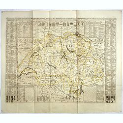
Carte generale des treize cantons Suisse et des differents etats de leur dependence . . .
Striking large format map of Switzerland, divided by Cantons and other dependent regions. Includes 13 large coats of arms and 22 smaller coats of arms for the various maj...
Date: Amsterdam, 1728
Selling price: ????
Please login to see price!
Sold in 2017

(Ichan / Cha Ichan / Oranzeb / Badour Siah)
From Chatelain's monumental 7 volume Atlas Historique. Henri Abraham Chatelain (1684 – 1743) was a Huguenot pastor of Parisian origins. He lived consecutively in Paris,...
Date: Amsterdam, 1728
Selling price: ????
Please login to see price!
Sold in 2017
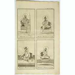
(Tamberlan / Miracha / Mohamed / Abuchaid)
From Chatelain's monumental 7- volume Atlas Historique. Henri Abraham Chatelain (1684 – 1743) was a Huguenot pastor of Parisian origins. He lived consecutively in Paris...
Date: Amsterdam, 1728
Selling price: ????
Please login to see price!
Sold in 2018
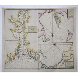
DRAM and CHRISTIANIA / HARBOUR of REVEL / DANTZICK and KONINGSBERG
A scarce sea chart with three inset maps of Oslo (Christiania); Danzig and Kaliningrad (Konigsberg); and Tallin, Estonia.This very rare work was a collaborative effort of...
Date: London, 1728
Selling price: ????
Please login to see price!
Sold in 2017
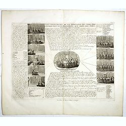
Gouvernement de La Compagnie des Indes..
Interesting print showing the six chambers of the Dutch VOC (United East India Company): Amsterdam, Zeeland, Rotterdam, Delft, Hoorn and Enkhuizen. In the center print of...
Date: The Hague, 1728
Selling price: ????
Please login to see price!
Sold in 2017
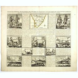
Coutumes Moeur & Habillemens..du Cap de Bonne Esperance..
In top a small map of Southern Africa (100 x 120 mm.) and 10 engravings of natives and animals of Southern Africa. In top an unusual map of Africa almost identical to tha...
Date: Amsterdam, 1728
Selling price: ????
Please login to see price!
Sold in 2018
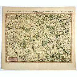
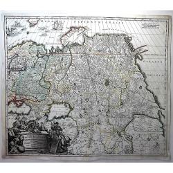
Nouvelle carte des etats du grand duc de Moscovie en Europe.
Northern part of European Russia, Lithuania, Poland and the Ukraine with many references to Cossacks.Zacharie Chatelain (d.1723) was the father of Henri Abraham (1684-174...
Date: Amsterdam, 1728
Selling price: ????
Please login to see price!
Sold in 2017
Carte cronologique et Historique pour servir a l'histoire d'Espagne.
This impressive engraving is a wonderful example of Chatelain’s elegant plates showing a genealogical chart and portraits of the kings of Spain and Portugal, from 406AD...
Date: Amsterdam, 1728
Selling price: ????
Please login to see price!
Sold in 2018
Carte Historique & Cronologique pour Servir d'Introduction a l'Histoire des Provinces Unies des Païs-Bas.
This folio sheet shows a genealogical chart and portraits of the rulers of Holland and Flanders with descriptive French text, from Chatelain's monumental 7 volume "A...
Date: Amsterdam, 1728
Selling price: ????
Please login to see price!
Sold in 2018
![[Title page] Atlas Historique.](/uploads/cache/39003-250x250.jpg)
[Title page] Atlas Historique.
Decorative page from Chatelain's monumental 7 volume Atlas Historique, showing allegories of History, Geography, Astronomy, Fame, Sea and Navigation. Henri Abraham Chatel...
Date: Amsterdam, 1728
Selling price: ????
Please login to see price!
Sold in 2021
Jaffenapatnam.
A bird's eye-view of the fort and town of Jaffna. From Francois Valentyn's "Oud en Nieuw Oost Indien". The view depicts Jaffnapatnam, the fort on the coast of S...
Date: Amsterdam, 1728
Selling price: ????
Please login to see price!
Sold in 2019
Carte historique cronologique de l'empire Romain ou l'on fait observer son etendue et diverses remarques pour l'intelligence de l'histoire . . .
In the center a map (207 x 446mm.) of the extent of the Roman Empire (Europe and the Middle East). Above and below extensive explanatory notes. Shown is the track of Juli...
Date: Amsterdam, 1728
Selling price: ????
Please login to see price!
Sold in 2018
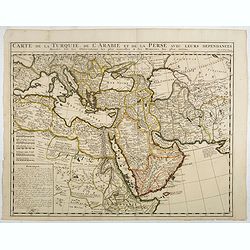
Carte de la Turquie, de la L'Arabie et de la Perse..
Including the Arabian Peninsular, Egypt, Persia, Caspian Sea, north eastern part of Africa, Cyprus and Mediterranean. From Chatelain's monumental 7 volume "Atlas His...
Date: Amsterdam, 1728
Selling price: ????
Please login to see price!
Sold in 2017
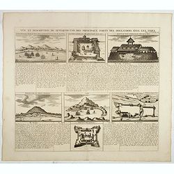
Vue et description de quelques-uns des principaux forts des Hallandois dans les Indes.
Interesting sheet with seven detailed views illustrating the most important Dutch trading outposts and fortified colonial possessions in South East Asia, including 4 harb...
Date: Amsterdam, 1728
Selling price: ????
Please login to see price!
Sold in 2018
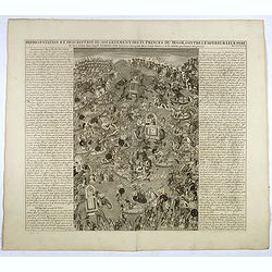
Representation Et Description Du Soulevement Des IV. Princes Du Mogol Contre L'Empereur Leur Père du Combat dans lequel Aureng-Zeb demeura vainqueur dese trois Freres & c. sit ensuite proclamer Empereur.
Fascinating engraving depicting a grand battle between the princes of the Mughal Empire. Aurangzeb was the last of the great Mughal emperors and the empire reached its la...
Date: Amsterdam, 1728
Selling price: ????
Please login to see price!
Sold in 2017
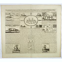
Description des castors & de leur industrie . . .
Fascinating engraving depicting how people from Canada use castors in many ways.Henri Abraham Chatelain (1684 – 1743) was a Huguenot pastor of Parisian origins. He live...
Date: Amsterdam, 1728
Selling price: ????
Please login to see price!
Sold in 2017
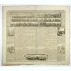
Description du pelerinage des turcs a la Mecque et a Medine . . .
Fascinating engraving depicting Turkish peoples en route from the gates of Cairo to visit their holy sites in Mecca and Medina is in a beautifully detailed vignette which...
Date: Amsterdam, 1728
Selling price: ????
Please login to see price!
Sold in 2017
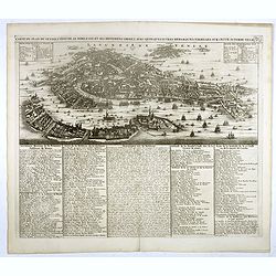
Carte du plan de Venise, l'état de sa noblesse, et ses differens degrez a ec quelques autres remarques curieuses sur cette superbe ville. Tome 2 N° 4.
Extremely detailed bird's-eye view of Venice with scores of ships and gondolas shown throughout. The text panels list monasteries, churches, palaces, bridges, and the nam...
Date: Amsterdam, 1728
Selling price: ????
Please login to see price!
Sold in 2018
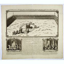
Le temple de la Mecque avec une description de tout ce qu'on y voit . . .
Fascinating engraving depicting the Muslim Kaaba at Mecca. Below the main image are two smaller vignette images of people praying. In between the two vignettes is a key (...
Date: Amsterdam, 1728
Selling price: ????
Please login to see price!
Sold in 2017
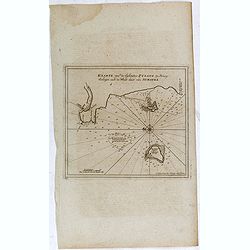
Kaarte van de Eylanden Pysang, by Padang. Gelegen aan de West kust van Sumatra.
Very rare chart of Pisang Island, a small island near Padang, on the west coast of Sumatra, Indonesia. Oriented to the west, this map covers the coast of Padang, and the ...
Date: Amsterdam, 1728
Selling price: ????
Please login to see price!
Sold in 2017
Carte genealogique de la suite des empereurs d'orient de Trebisonde, d'Andrinople et Ottomans. . .
With a small inset map at the lower center, this grand genealogical table displays the Kings of the Orient and the Ottomans, with those of Jerusalem, Cyprus and Armenia.H...
Date: Amsterdam, 1728
Selling price: ????
Please login to see price!
Sold in 2019
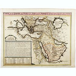
Carte de L'Empire des Turcs en Asie & en Afrique..
Including the Arabian Peninsula, Egypt, Cyprus, and part of the Mediterranean. In the upper right corner is a large Caspian Sea, filled with notes. To the right, the Rive...
Date: Amsterdam, 1728
Selling price: ????
Please login to see price!
Sold in 2025
Generalis Totius Imperii Moscovitici Novissima Tabula. . .
A large map showing the whole of Russia; from the Black Sea and the Baltic to Kamchatka, China, and Northern India. Beautifully engraved and highly detailed, the map show...
Date: Neurenberg, 1728
Selling price: ????
Please login to see price!
Sold in 2018
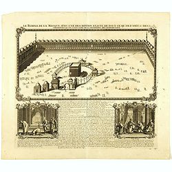
Le temple de la Mecque avec une description de tout ce qu'on y voit . . .
Fascinating engraving depicting the Muslim Kaaba at Mecca, Arabia. Below the main image are two smaller vignette images of people praying. In between the two vignettes is...
Date: Amsterdam, 1728
Selling price: ????
Please login to see price!
Sold in 2018
Carte historique chronologique et géographique de l'empire Grec . . .
Interesting sheet with a map of the Roman Empire, with descriptive French text, from Chatelain's monumental 7 volume Atlas Historique.Henri Abraham Chatelain (1684 – 17...
Date: Amsterdam, 1728
Selling price: ????
Please login to see price!
Sold in 2021
![[Title page] Atlas Historique ou nouvelle introduction à l'Histoire, à la Chronologie & à la Géographie Ancienne & Moderne . . . (Tome VI)](/uploads/cache/38991-250x250.jpg)
[Title page] Atlas Historique ou nouvelle introduction à l'Histoire, à la Chronologie & à la Géographie Ancienne & Moderne . . . (Tome VI)
Title page from Chatelain's monumental 7 volume Atlas Historique, Tome VI. Henri Abraham Chatelain (1684 – 1743) was a Huguenot pastor of Parisian origins. He lived con...
Date: Amsterdam, 1728
Selling price: ????
Please login to see price!
Sold in 2019
![[Title page] Atlas Historique ou nouvelle introduction à l'Histoire, à la Chronologie & à la Géographie Ancienne & Moderne . . . (Tome II)](/uploads/cache/38999-250x250.jpg)
[Title page] Atlas Historique ou nouvelle introduction à l'Histoire, à la Chronologie & à la Géographie Ancienne & Moderne . . . (Tome II)
Title page from Chatelain's monumental 7 volume Atlas Historique, Tome II. Henri Abraham Chatelain (1684 – 1743) was a Huguenot pastor of Parisian origins. He lived con...
Date: Amsterdam, 1728
Selling price: ????
Please login to see price!
Sold in 2018
![[Title page] Atlas Historique ou nouvelle introduction à l'Histoire, à la Chronologie & à la Géographie Ancienne & Moderne . . . (Tome V)](/uploads/cache/39000-250x250.jpg)
[Title page] Atlas Historique ou nouvelle introduction à l'Histoire, à la Chronologie & à la Géographie Ancienne & Moderne . . . (Tome V)
Title page from Chatelain's monumental 7 volume Atlas Historique, Tome V. Henri Abraham Chatelain (1684 – 1743) was a Huguenot pastor of Parisian origins. He lived cons...
Date: Amsterdam, 1728
Selling price: ????
Please login to see price!
Sold in 2019
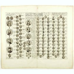
Carte Historique & Cronologique pour Servir d'Introduction a l'Histoire des Provinces Unies des Païs-Bas.
This folio sheet shows a genealogical chart and portraits of the rulers of Holland and Flanders with descriptive French text, from Chatelain's monumental 7 volume "A...
Date: Amsterdam, 1728
Selling price: ????
Please login to see price!
Sold in 2019
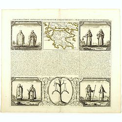
Carte de la Grece contenant l'Etat present de l'Eglise Grecque &. . .
Handsome chart with a small map of Greece (115 x 150mm.) together with five Greek religious scenes and descriptive French text.Zacharie Chatelain (d.1723) was the father ...
Date: Amsterdam, 1728
Selling price: ????
Please login to see price!
Sold in 2020

Le temple de la Mecque avec une description de tout ce qu'on y voit . . .
Fascinating engraving depicting the Muslim Kaaba at Mecca. Below the main image are two smaller vignette images of people praying. In between the two vignettes is a key (...
Date: Amsterdam, 1728
Selling price: ????
Please login to see price!
Sold in 2024
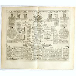
Carte genealogique de la Pologne et les principalles branches ses rois.
Genealogical tree, showing the lineage of the Polish Kings, dating back to 700. Henri Abraham Chatelain (1684 – 1743) was a Huguenot pastor of Parisian origins. He live...
Date: Amsterdam, 1728
Selling price: ????
Please login to see price!
Sold in 2018
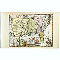
La Floride suivant les nouvelles observations...
Uncommon edition of this map of Florida. From Le Nouveau Theatre du Monde, ou la Geographie Royale.
Date: Amsterdam, 1728
Selling price: ????
Please login to see price!
Sold in 2020
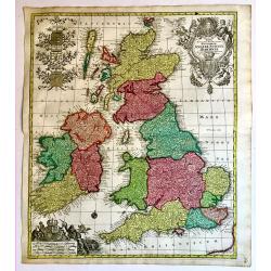
Regnorum Angliae, Scotiae Hiberniae.
A superb 18th century original hand colored map of Seutter's British Isles, with a portrait of George I and the Hanoverian coat-of-arms in the title cartouche. In the sca...
Date: Augsburg, 1728
Selling price: ????
Please login to see price!
Sold in 2019
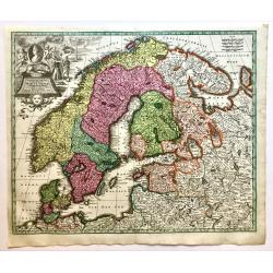
Synopsis Plagae Septentrionalis size Sueciae Daniae et Norwegiae Regn.
A superb 18th century original hand colored map of Scandinavia that extends to the east to include portions of Russia, the Baltic states, and the northern part of Germany...
Date: Vienna, 1728
Selling price: ????
Please login to see price!
Sold in 2019
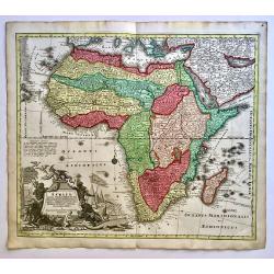
Africa Iuxta Navigationes et Observationes Recentissimas Aucta Correcta et in Sua Regna et Status Divisa, in Lucem Edita.
A beautifully hand colored and very detailed map of Africa, with a fine dark impression. The map is typical of the period with the information in southern Africa being la...
Date: Vienna, 1728
Selling price: ????
Please login to see price!
Sold in 2019
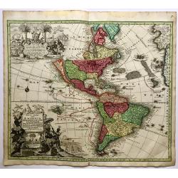
Novus Orbis Sive America Meridionalis et Septentrionalis.
A highly detailed and richly engraved Seutter's map of America, with two spectacular cartouches and showing California as an island. The island is based on the second San...
Date: Vienna, 1728
Selling price: ????
Please login to see price!
Sold in 2019
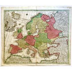
Europa Religionis Christianae. . .
A superb 18th century original hand colored regional map of Europe with a spectacular cartouche featuring religious and allegorical figures signifying Christianity as a m...
Date: Augsburg, 1728
Selling price: ????
Please login to see price!
Sold in 2019
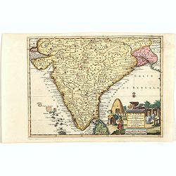
L'Inde de ça le Gange, suivant les nouvelles observations...
Uncommon edition of this map of South of India, with part of Ceylon. From Le Nouveau Theatre du Monde, ou la Geographie Royale.
Date: Amsterdam, 1728
Selling price: ????
Please login to see price!
Sold in 2021
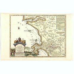
Le Cap de Bonne Esperance, suivant les nouvelles observations..
This is a small detailed map of the Cape from Saldanha to False Bay. The attractive title cartouche on the lower left is on a stone pediment surmounted by a lion and lion...
Date: Amsterdam, 1728
Selling price: ????
Please login to see price!
Sold in 2019
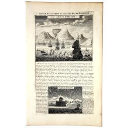
VUE et DESCRIPTION du Cap De BONNE ESPERANCE.
In top copperplate engraving of the Cape with shipping in the foreground flying the Dutch flag, with engraved descriptive text between the two views, mainly concerning th...
Date: Amsterdam, 1728
Selling price: ????
Please login to see price!
Sold in 2019
![[4 sheets] Portraits du Grand Seigneur G des principaux Officiers de l'Empire Ottoman, tirez .... / Portraits du grand seigneur é des principaux officiers de l'empire Ottoman . / Viandes & breuvages des Turcs / La maniere dont les Turcs mangent](/uploads/cache/83054-250x250.jpg)
[4 sheets] Portraits du Grand Seigneur G des principaux Officiers de l'Empire Ottoman, tirez .... / Portraits du grand seigneur é des principaux officiers de l'empire Ottoman . / Viandes & breuvages des Turcs / La maniere dont les Turcs mangent
Four engraved, decorative sheets showing images of Turcs officials and cultural images. Each sheet measures 37 x 43 cm. except the smaller which measures 38 x 23cm.From C...
Date: Amsterdam, ca. 1728
Selling price: ????
Please login to see price!
Sold in 2019
![Statuum MAROCCANORUM. Regnorum nempe Fessanim Maroccani, Tafiletani et Segelomessani... [Canary islands]](/uploads/cache/83546-250x250.jpg)
Statuum MAROCCANORUM. Regnorum nempe Fessanim Maroccani, Tafiletani et Segelomessani... [Canary islands]
Scarce map of Morocco, with two city views below. Includes a striking allegorical cartouche and inset map of Madeira,and the Canary islands.
Date: Nuremberg, 1728
Selling price: ????
Please login to see price!
Sold in 2020
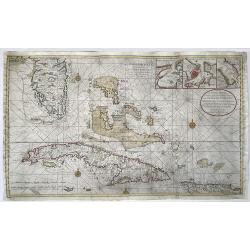
Nieuwe en Naeukeurige Afteekening vant Canaal van Bahama... / Nouvelle Carte Marine du Canal de Bahama...
Large size nautical sea chart of the Florida peninsula, Bahamas, Cuba and Hispaniola. Printed on two sheets, joined.Southern Florida and the Keys are depicted with great ...
Date: Amsterdam, 1728
Selling price: ????
Please login to see price!
Sold in 2022
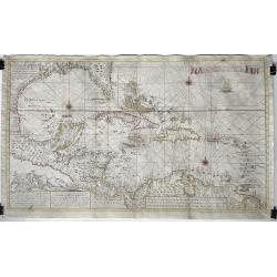
Nouvelle Carte Marine de Toute les Cotes de l´Amerique ... / Nieuwe grote en zeer curieuze Paskaart van Geheel WestIndien ...
Large size sea chart of the Caribbean and surrounding coasts, by Gerard van Keulen, son of Johannes Van Keulen. A rare map since these larger-sized sheets were never publ...
Date: 1728
Selling price: ????
Please login to see price!
Sold in 2022
Carte chronologique des etats et empires du monde, qui se sont former de la chute de l’empire romain, depuis le commencement de . . .? vulgaire, jusqu’a present. . .
Extremely interesting sheet with a small map of Europe at the center and chronological tables in French tracing the ancestry of the royal houses of Europe. From: Atlas ...
Date: Amsterdam, 1728
Selling price: ????
Please login to see price!
Sold in 2023
![[Lot of 2 maps] Carte de la Terre Ferme, du Perou, du Bresil, et du Pays des Amazones. . . /](/uploads/cache/48132-250x250.jpg)
[Lot of 2 maps] Carte de la Terre Ferme, du Perou, du Bresil, et du Pays des Amazones. . . /
A handsome pair of maps that together make up South America. The first map is of the northern part of South America based on the cartography of Guillaume Delisle.It is fi...
Date: Amsterdam, 1728
Selling price: ????
Please login to see price!
Sold in 2022
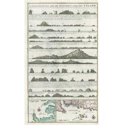
Landkenningen Aen De Zuyd West Syde Van Ysland
A rare cartographic work showing the coastlines of Iceland as they would appear from a ship at sea. The map title and descriptions of the coat are all done in Islandic la...
Date: Amsterdam, 1728
Selling price: ????
Please login to see price!
Sold in 2023
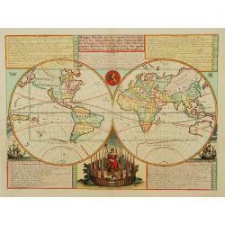
Mappe-Monde pour connoitre..
A double hemisphere world map set against tables on notes of discoveries and divisions of the earth interspersed with vignettes of sailing ships and the marks of the VOC ...
Date: Amsterdam 1728
Selling price: ????
Please login to see price!
Sold
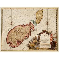
L'ile de Malte, anciennement Melita..
Fine map depicting Malta. Embellished with a very beautiful title cartouche showing an historical scene.From van der Aa's very rare work "La galerie agréable du Mon...
Date: Leiden, c.1728
Selling price: ????
Please login to see price!
Sold