Browse Listings
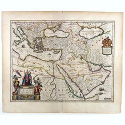
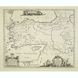
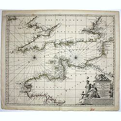
Turcicum Imperium.
A very handsome map with a particularly fine cartouche showing the Turkish Sultan on his throne and allegorical figures at either side brandishing weapons. At right is a ...
Date: Amsterdam, 1658
Selling price: ????
Please login to see price!
Sold in 2025
Imperii Caroli Magni..
Prepared by Petrus Bertius in 1616. Very large historical wall map (4 sheets joined) depicting the empire of Charles the Great.Fully engraved with mountains, forests, and...
Date: Amsterdam, 1658
Selling price: ????
Please login to see price!
Sold in 2023
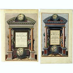
(Title page) Theatrum orbis Terrarum sive Atlas Novus pars Tertia. / Novus Atlas, sive Theatrum Orbis Terrarum: in quo Orbis Antiquus. . .
A pair of glorious mid seventeenth century engraved frontispieces to atlases by Blaeu and Jansson. The Blaeu frontispiece is of the third part of his 'Theatrum Orbis Terr...
Date: Amsterdam, 1650 - 1658
Selling price: ????
Please login to see price!
Sold in 2018
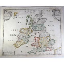
Carte Generale Des Royaume d'Angleterre, Ecosse et Irelande.
A fine example of Sanson's first map of the British Isles. The distortion of lreland and the condensed size of Scotland was caused by the projection used by Sanson. This ...
Date: Paris, 1658
Selling price: ????
Please login to see price!
Sold in 2018
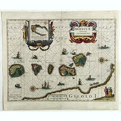
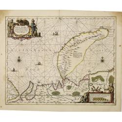
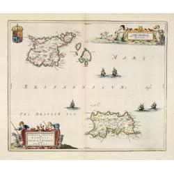
Moluccae Insulae Celeberrimae.
Showing the geographical features of the spice islands, and decorated with ships, sea monsters and a handsome cartouche. In addition to a sumptuous title cartouche, the m...
Date: Amsterdam, 1658
Selling price: ????
Please login to see price!
Sold in 2022
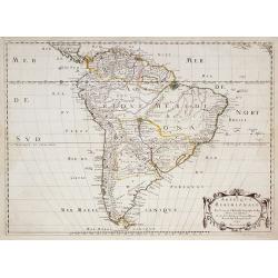
![[Title page] Nieuwen ATLAS ofte Weereldt-Beschrijvinghe Eerste Deels Vervolgh / Inhoudende Duytschlandt.](/uploads/cache/44675-250x250.jpg)
[Title page] Nieuwen ATLAS ofte Weereldt-Beschrijvinghe Eerste Deels Vervolgh / Inhoudende Duytschlandt.
At the top two eagles support six armorial shields and within the embrace of a large Imperial double-headed eagle -each head with its golden halo - is the same double hea...
Date: Amsterdam, 1658
Selling price: ????
Please login to see price!
Sold in 2019
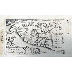
Chinae Compendiosa Descriptio.
A scarce early map of China with beautiful geographic detail. Published in "Historiae Universalis Auctarium". Page marked "XXVIII".
Date: Ulm, 1658
Selling price: ????
Please login to see price!
Sold in 2020
Etats du Czar ou Grand Duc de la RUSSIE.
Map of the European part of Russia by one of the most important French mapmaker. Engraved by A. Peyrouin.
Date: Paris, 1650-1659
Selling price: ????
Please login to see price!
Sold in 2012
Civitatis Imp. Lindaviensis Territorium.
Hand-colored copper engraved map of Lindau (Bodensee), Germany. Two beautiful strapwork cartouches with scale cartouche with two putti holding it. Also two pillars dat3ed...
Date: Amsterdam, 1659
Selling price: ????
Please login to see price!
Sold in 2017
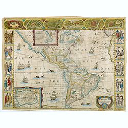
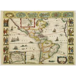
America noviter delineata.
Rare map of the America's published in Pierre D'Avity's Les Etats... With figured borders on three sides and drawn from the Picart map of 1644, itself derived from the se...
Date: Paris, 1659
Selling price: ????
Please login to see price!
Sold in 2014
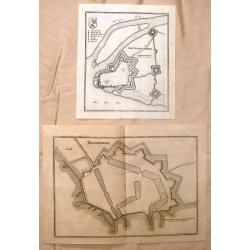
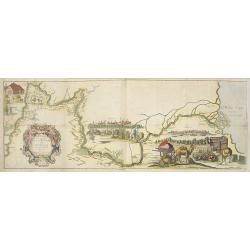
Gertruydenberg and Vlissingen (Flushing)
Striking city plans of Gertruydenberg by Caspar Merian in 1659. Caspar Merian (1627-1686) was one of the most important topographical engravers and publishers of the Ba...
Date: Frankfurt am Main, 1659
Selling price: ????
Please login to see price!
Sold in 2016
![[Set of 4 continents] America Noviter Delineata, Asia Recens Summa Cura Delineata, Africa Nova Tabula and Nova Europae Descriptio](/uploads/cache/97484-250x250.jpg)
[Set of 4 continents] America Noviter Delineata, Asia Recens Summa Cura Delineata, Africa Nova Tabula and Nova Europae Descriptio
A magnificent and rare set of the 4 continents by Pierre D'Avity. The maps are from the French work "Les Etats, Empires, Royaumes du Monde". The engraver is unk...
Date: Paris, 1659
Selling price: ????
Please login to see price!
Sold in 2019
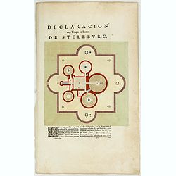
Declaracion del Traco en llano de Steleburg.
Decorative plan of Steleburg on the island Hvan in the Danish Sound. Showing Tycho Brahe's famous observatory Uraniborg established in 1576, under the patronage of Freder...
Date: Amsterdam, 1659
Selling price: ????
Please login to see price!
Sold in 2020
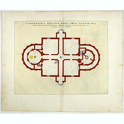
Ichnographia praecipue domus
Decorative plan of Uraniborg, the observatory build by the Danish astronomer Tycho Brahe. The building was dedicated to Urania, the Muse of Astronomy, and called "Ur...
Date: Amsterdam, 1659
Selling price: ????
Please login to see price!
Sold in 2020
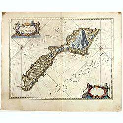
Insula que a Joanne Mayen nomen sortita est.
Jan Mayen is an isolated island in the northern Atlantic, lying between 70-72° North and 8-9° West, about 550 kilometers northeast of Iceland and 500 kilometers east of...
Date: Amsterdam, 1659
Selling price: ????
Please login to see price!
Sold in 2025
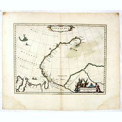
Nova Zemla.
The Dutch were the most persistent searchers after the north-east Passage, whether to the north of Novaya Zemlya (whose west coast is shown in detail) or through what the...
Date: Amsterdam, 1659
Selling price: ????
Please login to see price!
Sold in 2025
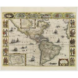
America noviter delineata.
Rare map of the America's published in Pierre D'Avity's Les Etats... With figured borders on three sides and drawn from the Picart map of 1644, itself derived from the se...
Date: Paris, 1659
Selling price: ????
Please login to see price!
Sold in 2016
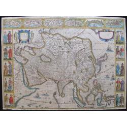
Asia recens summa cura delineata Auct. Jud. Hondio
A rare decorative ‘Carte à Figures’ map of Asia, which appeared in the 1659 edition of Pierre D'Avity's Les Etats Empires, Royaumes et Principautez du Monde. The map...
Date: Paris, 1618 but 1659
Selling price: ????
Please login to see price!
Sold in 2016
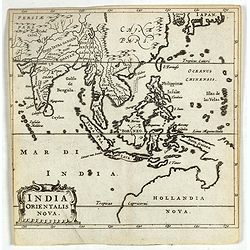
India Orientalis Nova.
Charming uncommon miniature map showing the northern two-thirds of Australia pre-discoveries by Captain Cook, but showing discoveries by Abel Tasman in 1642. The map show...
Date: Amsterdam, 1659
Selling price: ????
Please login to see price!
Sold in 2017
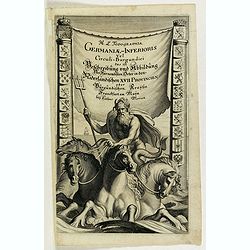
Topographia Germaniae Inferioris. Das ist Beschreibung und Abbildung der vornehmsten Staetten ... in den XVII Niderlaendischen Provintien.
Title page from "Topographia Germaniae Inferioris. Das ist Beschreibung und Abbildung der vornehmsten Staetten … in den XVII Niderlaendischen Provintien.".Bor...
Date: Frankfurt, 1659
Selling price: ????
Please login to see price!
Sold in 2018
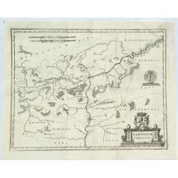
Namurcum Comitatus.
A fine map of the surrounding area around Namur, Belgium, part of the Spanish Netherlands. The map with the Sambre and Meuse rivers and other places like Dunant. It feat...
Date: Frankfurt, 1659
Selling price: ????
Please login to see price!
Sold in 2018
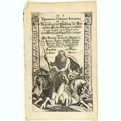
Topographia Germaniae Inferioris. Das ist Beschreibung und Abbildung der vornehmsten Staetten ... in den XVII Niderlaendischen Provintien.
Title page from "Topographia Germaniae Inferioris", describing the Benelux. Born in Basel, Matthaeus Merian studied in Zurich and then worked in Strasbourg, Nan...
Date: Frankfurt, 1659
Selling price: ????
Please login to see price!
Sold in 2020
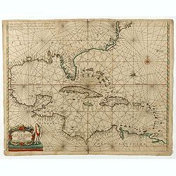
Pascaerte vande Caribische Eylanden, vande Barbados tot aende Bocht van Mexico ‘t Amsterdam By Hendrick Doncker. . .
First state. Rare. “This chart appeared in the first edition of Hendrick Doncker’s Zee-Atlas, of which no surviving example is known” -- Burden. This is an example ...
Date: Amsterdam, 1659
Selling price: ????
Please login to see price!
Sold in 2020
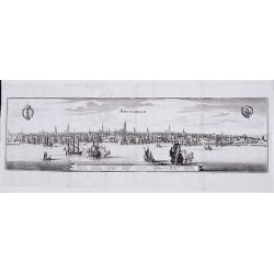
Amsterdam.
A panoramic view of the town from 't IJ.
Date: Frankfurt, 1659
Selling price: ????
Please login to see price!
Sold in 2021
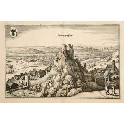
Munchenstein.
A bird's-eye view of Munichstein, with in the background the town of Basle. From Merian's Theatrum Europaeum.
Date: Frankfurt 1659
Selling price: ????
Please login to see price!
Sold
America noviter delineata.
Rare map of the America's published in Pierre D'Avity's Les Etats, Empires Royaumes...du Monde... The plate was engraved with figured borders on three sides and is drawn ...
Date: Paris, 1659
Selling price: ????
Please login to see price!
Sold in 2016
![[Untitled] Malta.](/uploads/cache/23373-250x250.jpg)
[Untitled] Malta.
RARE. Bird's eye-view of Malta showing an escutcheon with the Maltese Cross in the upper left corner. With vessels and galleys approaching the harbor.
Date: Padua, 1658 - 1659
Selling price: ????
Please login to see price!
Sold in 2014
America noviter delineata.
Extremely rare map of the America's published in Pierre D'Avity's Les Etats... With figured borders on three sides and drawn from the Picart map of 1644, itself derived f...
Date: Paris 1659
Selling price: ????
Please login to see price!
Sold
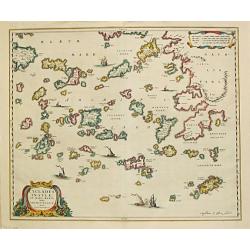
Cyclades Insulae In Mari Aegaeo, hodie Archipelago.
Johan Blaeu succeeded his father Willem when the latter died in 1638. Johan led the Blaeu firm to its greatest achievement, the ' Atlas Maior' in 12 parts, the greatest a...
Date: Amsterdam, 1659
Selling price: ????
Please login to see price!
Sold
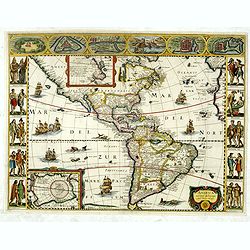
America noviter delineata. Auct: Judoco Hondio.
Fine map of the American continent with insets of the South and North Pole on the left hand side.Panels on the left, right and top borders, as in the Blaeu Americas. Note...
Date: Amsterdam 1659
Selling price: ????
Please login to see price!
Sold
Burgos.
A bird's-eye view of Burgos from Merian's "Theatrum Europaeum".
Date: Frankfurt, 1659
Selling price: ????
Please login to see price!
Sold in 2008
![[No tile - Bavaria]](/uploads/cache/26977-250x250.jpg)
[No tile - Bavaria]
Charming little map of part of Souther Germany, including de river Danube, made by Gabriel Bucelin (1599-1681). Bucelin was a Swiss genealogist and an author of several b...
Date: Ulm, Johannes Görlin, 1659
Selling price: ????
Please login to see price!
Sold in 2011
Amerique Meridionale . . .
A fine large map of South America. The relatively unknown Amazon region is left without speculation. However, Sanson includes the mythical Lac de Parime with Manoa del Do...
Date: Paris, 1650-1659
Selling price: ????
Please login to see price!
Sold in 2013
Le Cours de la Riviere de Wolga Anciennement appellee RHA Dedie A Monsieur Vion . . . 1659.
Olearius' more than one meter map of the Volga River, from the 1659 edition of Olearius' Relation du voyage d'Oléarius Adam en Moscovie, Tartarie, et Perse avec celui de...
Date: Paris, 1659
Selling price: ????
Please login to see price!
Sold in 2010
Nova Zemla, Waygats, Fretum Nassovicum, et terra Samoiedum singula ómnium emendatissime descripta.
Shows Novaya Zemlya and northern continental coastline. Includes notes on 1594/95/96 discoveries. Illustrated with sailing ships, sea monsters, various people and animals...
Date: Amsterdam, 1659
Selling price: ????
Please login to see price!
Sold in 2010
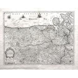
Comitatus Flandria Noua Tabula.
Finely detailed map of Flanders by Sanson published by Pierre Mariette. Shows the Flemish coastal region from Calais and Dunkirk, France to Antwerp, Belgium and includes...
Date: Paris, 1654-1659
Selling price: ????
Please login to see price!
Sold in 2010
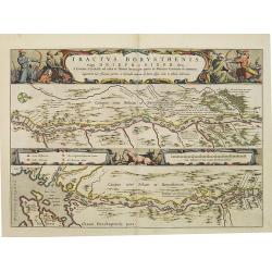
Tractus Borysthenis vulgo Dniepr et Niepr Dicti, à Bovzin . . .
This superb map shows the upper part of the Dnieper River in two horizontal strips, the upper map with a compass rose orienting the map, west to the top. It is richly emb...
Date: Amsterdam, 1659
Selling price: ????
Please login to see price!
Sold
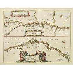
Tractus Borysthenis vulgo Dniepr et Niepr Dicti, A Civitate Czyrkassii as ostia et Ilmien lacum, per quem in Pontum Euxinium se exonerat . . .
This superb map shows the upper part of the Dnieper River in two horizontal strips, the upper map with a compass rose orienting the map, west to the top. It is richly emb...
Date: Amsterdam, ca. 1659
Selling price: ????
Please login to see price!
Sold
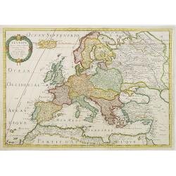
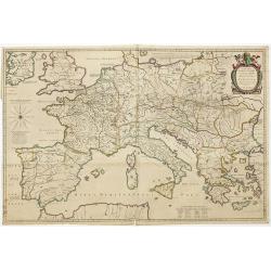
L'Europe
Fine map of Europe, with address of Pierre Mariette: rue st.Jacques a L'Esperance .Nicolas Sanson was to bring about the rise of French cartography, although the fierce c...
Date: Paris, 1650-1659
Selling price: ????
Please login to see price!
Sold in 2011
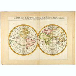
Harmonie ou Correspondance du Globe avecq la Sphere par les Points, Lignes, Cercles, &c. qui se descrivent en la surface des Globes Terrestres et des Mappemondes, pour respondre a ceux qui sont imaginés dans la Sphere Cœleste.
A large map of the world in two hemispheres, east and west, showing the climatic zones. The geographic content is relegated to the background, placing emphasis on the gri...
Date: Paris,'"chez l'autheur", 1659
Selling price: ????
Please login to see price!
Sold in 2021
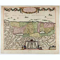
Terra Sancta sive Promissionis, olim Palestina..
Apparently this same plate was used by later cartographers, such as De Wit. The top portion with cartouche was taken from a John Speed map of the Holy Lands.
Date: Amsterdam, 1659
Selling price: ????
Please login to see price!
Sold in 2023
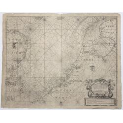
Pas Caert van Texel tot aen de Hoofden.
An attractive chart of the North Sea. Hendrick Doncker was one of the leading Amstrdam-based publshers of sea-atlases and sea charts
Date: Amsterdam, 1659
Selling price: ????
Please login to see price!
Sold in 2023
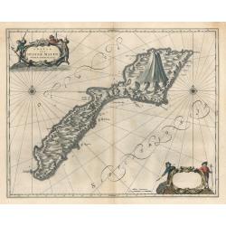
Insula Quae a Ioanne Mayen Nomen Sortita Est.
This remarkable map by Johannes Blaeu depicts the island of Jan Mayen, upon which is located the northernmost volcano on planet Earth, Beerenberg. It is a small island in...
Date: Amsterdam 1659
Selling price: ????
Please login to see price!
Sold in 2023
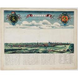
Brussel.
Panoramic view of the city of Brussels seen from the South. Title in a banner at top centre, left and right the coats-of-arms of Brabant and Brussels. Underneath a poetic...
Date: Amsterdam, ca. 1660
Selling price: ????
Please login to see price!
Sold in 2021
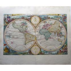
Orbis Terrarum Tabula. . .
A scarce first state of this double hemisphere world map taken from a Ravensteyn bible printed as early as 1660 (!) and on very large paper format. Superbly engraved wit...
Date: Leiden, 1660
Selling price: ????
Please login to see price!
Sold in 2020
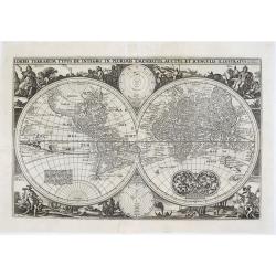
Orbis Terrarum Typus de Integro in Plurimis Emendatus, Auctus, et Icunculius Illustratus.
A highly decorative double hemisphere world map, surrounded by engravings that include allegorical representations of the continents, as well as native inhabitants and wi...
Date: Amsterdam, ca 1660
Selling price: ????
Please login to see price!
Sold in 2021
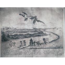
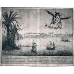
Olinda
This is a reduced version of the famous view of Olinda (Pernabuco, north east of Brazil) derived by the famous work of Barlaeus entitled "Rerum per octennium in Bras...
Date: Amsterdam, ca 1660
Selling price: ????
Please login to see price!
Sold in 2022
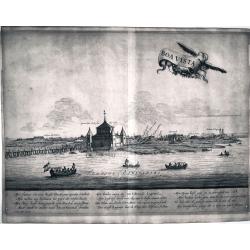
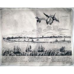
Boa Vista
This is a reduced version of the famous view of Boa Vista derived by the famous work of Barlaeus entitled "Rerum per octennium in Brasilia et alibi gestarum..."...
Date: Amsterdam, ca 1660
Selling price: ????
Please login to see price!
Sold in 2022
Parayba
This is a reduced version of the famous view of Parayba derived by the famous work of Barlaeus entitled "Rerum per octennium in Brasilia et alibi gestarum...", ...
Date: Amsterdam, ca 1660
Selling price: ????
Please login to see price!
Sold in 2022
Acapitania de Paranambuca
This is a reduced version of the famous view of the Captaincy of Pernambuco or New Lusitania, derived by the famous work of Barlaeus entitled "Rerum per octennium in...
Date: Amsterdam, ca 1660
Selling price: ????
Please login to see price!
Sold in 2022
![[Lot of 5 maps of Greece]. Candia olim Creta.](/uploads/cache/IMG_0748-250x250.jpg)
[Lot of 5 maps of Greece]. Candia olim Creta.
Johannes Blaeu's attractive map of Crete. Johan Blaeu succeeded his father Willem when the latter died in 1638. Johan led the Blaeu firm to its greatest achievement the...
Date: Amsterdam, 1660
Selling price: ????
Please login to see price!
Sold in 2023
![[Lot of 3 maps] Candia olim Creta.](/uploads/cache/IMG_9432-250x250.jpeg)
[Lot of 3 maps] Candia olim Creta.
Johannes Blaeu's attractive map of Greta. Johan Blaeu succeeded his father Willem when the latter died in 1638. Johan led the Blaeu firm to its greatest achievement the '...
Date: Amsterdam, c. 1660
Selling price: ????
Please login to see price!
Sold in 2022
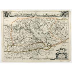
Novissima et emendata delineatio Hungariae una cum adjacentibus et finitimis regionibus.
First state. With two inset views of Buda and Bratislava (Posoniensis vulgo Presburg) above the map, between the half-lenght portraits of Leopold I. and the Turkish Sulta...
Date: Anvers ?, c. 1660
Selling price: ????
Please login to see price!
Sold in 2025
Carte Géographique des Postes qui traversent la France.
Attractive map of France shows post road mapspost routes connecting major cities, towns and harbors. Depicts sailing vessels in the British Channel and the Bay of Biscay ...
Date: Paris, 1632-1660
Selling price: ????
Please login to see price!
Sold
Tabula Itineris Decies Mille Graecorum sub Cyro... Per P. du Val. . .
Decorative map of Asia Minor, Cyprus and the neighboring areas, the map features the expedition of Cyprus the Great .Compiled and drawn by Pierre duVal for Janssonius' hi...
Date: Amsterdam, 1660
Selling price: ????
Please login to see price!
Sold in 2012
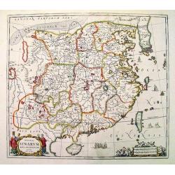
Imperii Sinarum.
Very attractive example of Van Loon's map published by Jan Janssonius. Superb coloring.
Date: Amsterdam, c. 1660
Selling price: ????
Please login to see price!
Sold
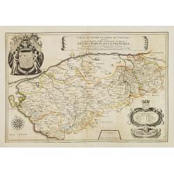
Carte du Duché et Pairie de Thouars dediée a Tres-Haut et Tres Puissant Prince Henri-Charles de la Tremoille . . .
Scarce map of the Touars Duchy with a beautiful coat of arms upper left and a title cartouche on center right. A key and a scale cartouche lower right. With a dedication ...
Date: Paris, 1660
Selling price: ????
Please login to see price!
Sold in 2013
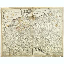
Carte generalle d'allemaigne nouvellement misse en françois et Ampliffiée de tous les Royaumes. . .
Attractive and rare map of Germany, the Low Countries, Austria, Switzerland and part of Poland.
Date: Paris, 1632-1660
Selling price: ????
Please login to see price!
Sold in 2017
Manica, gallis La Manche, et belgis Het Canaal.
Chart of the English Channel. Stretching from "Belle Isle" lower center, to Cardigan, top left- and Colchester, top right-hand side.
Date: Amsterdam, 1660
Selling price: ????
Please login to see price!
Sold in 2014
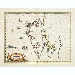
Spitsberga.
Blaeu's map of Spitsbergen was based on the Muscovy Company's map of 1625, but the north coast is completely new. It makes the heads of Wiche sound (Liefde bay) and Wyde ...
Date: Amsterdam, 1660
Selling price: ????
Please login to see price!
Sold in 2016
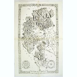
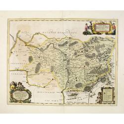
Il territorio Vicentino delineato per Angelo Gio. Novello, Agrimensor et intagliato da Marco Boschini.
Rare two-sheet map centered on Vicenza, situated in between Venice and Verona. North of Bassano de Grappa and Schio dramatic rendering of the mountains. The most southern...
Date: Venice, ca.1660
Selling price: ????
Please login to see price!
Sold in 2012
Nova totius terrarum orbis tabula auctore F. de Wit.
This is the first state of the world maps by F. de Wit. Especially rare, extremely decorative. It appeared in "De Zee-Atlas Ofte Water-Wereld ..." By Hendrik Do...
Date: Amsterdam, 1660
Selling price: ????
Please login to see price!
Sold in 2014
Sarnia Insula vulgo Garnsey et Insula Caesarea venacule Jarsey.
Very fine map depicting the English islands Jersey and Guernsey. Decorative cartouche with a shepherd, a shepherdess and sheep.The crown on top of the coat of arms height...
Date: Amsterdam, 1660
Selling price: ????
Please login to see price!
Sold in 2014
Provinces unies des Pays Bas. Par N. Sanson d'Abbeville. . .
Fine map of the present-day Netherlands. This edition carries un unfinished date "166 " and was engraved by R.Cordier Abbauil.Nicolas Sanson was to bring about ...
Date: Paris, after 1660
Selling price: ????
Please login to see price!
Sold in 2014
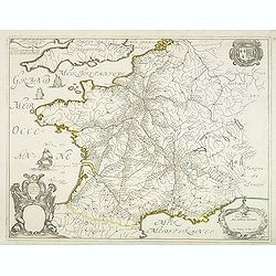
Description du Guienne.
Map of the Gascogne region, Aquitaine, including the coast of the Bay of Biscay, Bordeaux, Bayonne, San Sebastian, Bergerac, and Toulouse. North orientated to the left. ...
Date: Amsterdam, c1660
Selling price: ????
Please login to see price!
Sold in 2013
Nova Totius Terrarum Orbis Tabula.
This is the first state of the world maps by F. de Wit. Especially rare, extremely decorative.It appeared in "De Zee-Atlas Ofte Water-Wereld ..." By Hendrik Don...
Date: Amsterdam, 1660
Selling price: ????
Please login to see price!
Sold
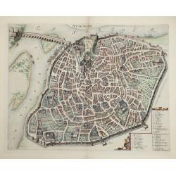
Avignon.
This rare bird's-eye plan depicts Avignon situated on both banks of the Sorgue River. A key locating 45 important sites is enclosed in the decorative cartouche at bottom ...
Date: Amsterdam, 1660
Selling price: ????
Please login to see price!
Sold in 2014
Ducatus Silesiae Grotganus cum Districtu Episcopali Nissensi Delineatore Iona Sculteto, Silesio.
Attractive old colored engraved map of Upper Silesia prepared by Joanus Scultetus, a Silesian cartographer (1603-1664) and published by J. Janssonius. Showing the area ar...
Date: Amsterdam, 1660
Selling price: ????
Please login to see price!
Sold in 2015
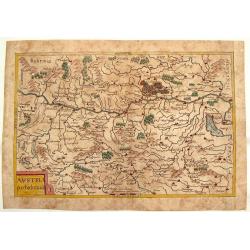
Austria Archducatus.
Quaint map of the Duchy of Austria along the Danube River. Features block cartouche.Matthäus Merian (1593 – 1650) was a Swiss -born engraver who worked in Frankfurt fo...
Date: Frankfurt, 1660
Selling price: ????
Please login to see price!
Sold in 2016
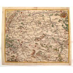
Palatinatus Rheni.
Striking map of the Palentine region of Germamy featuring the cities of Worms, Heydleberg and Kobelberg. A wonderful coat of arms cartouche with three lions decorates the...
Date: Frankfurt, 1660
Selling price: ????
Please login to see price!
Sold in 2015
Secfingen.
Hand-colored copper engraved aerial view of Sefingen, Austria. Featured places on the view include Schonawer hoffe, sreinerne Rhein bruck and Gallen Kirchl on the Rhenus ...
Date: Frankfurt, 1660
Selling price: ????
Please login to see price!
Sold in 2013
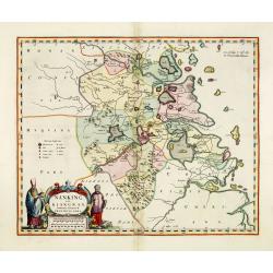
Nanking, sive Kiangnan, Imperii Sinarum Provincia Nona.
A map of Nanking, or Kiangnan, province (roughly corresponding to today's Jiangsu Province and Shanghai Municipality, after the Jesuit Martino Martini.Good detail of Yang...
Date: Amsterdam, ca 1660
Selling price: ????
Please login to see price!
Sold in 2013

Tabula IV sequitur Farnesiana Posticus.
Ornamental representation of the Vatican in Rome after Petrus Aqulia.
Date: Rome, 1660
Selling price: ????
Please login to see price!
Sold in 2014
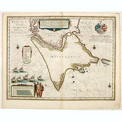
Tabula Magellanica, qua Tierra del fuego. . .
A map with Willem Blaeu's signature, but published by his son Joan, of South America's extremity with the Strait of Magellan and Le Maire Strait.The coastlines are depict...
Date: Amsterdam, 1660
Selling price: ????
Please login to see price!
Sold in 2014
Pecheli, Xansi, Xantung, Honan, Nanking, In plaga Regni Sinensis..
A map of the northern provinces of China after the Jesuit Martino Martini, Beijing, Shandong, Hanan and Jiangsu.Shows the Great Wall and covers northeastern China includi...
Date: Amsterdam, ca 1660
Selling price: ????
Please login to see price!
Sold in 2014
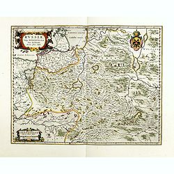
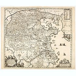
Russiae, vulgo moscoviae dictae, pars occidentalis.
A finely engraved depiction of the area from Estonia to Moscow. The map is based on the travels of Isaac Massa, who visited Moscow in the early 1600s and thus was in the ...
Date: Amsterdam, ca. 1660
Selling price: ????
Please login to see price!
Sold in 2014
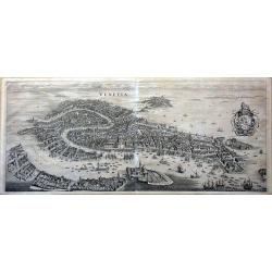
Venetia.
This famous bird's-eye town view of Venice and the lagoon area (Murano, Burano, Torcello etc.) is considered one of the influential of the time. It depicts in details the...
Date: Frankfurt, 1660
Selling price: ????
Please login to see price!
Sold in 2014
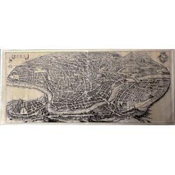
Roma.
This large, famous bird's-eye town view of Rome is considered one of the most influential of the time.It depicts in details the city's architectural landmarks. Extremely ...
Date: Frankfurt, 1660
Selling price: ????
Please login to see price!
Sold in 2014
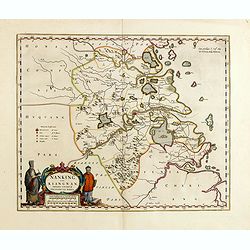
Nanking, sive Kiangnan, Imperii Sinarum Provincia Nona.
A map of Nanking, or Kiangnan, province (roughly corresponding to today's Jiangsu Province and Shanghai Municipality, after the Jesuit Martino Martini.Good detail of Yang...
Date: Amsterdam, ca 1660
Selling price: ????
Please login to see price!
Sold in 2015
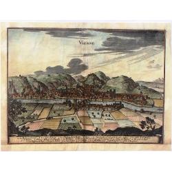
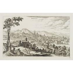
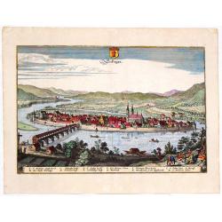
Vienne.
Striking view of the town and harbor of Vienne, France. Matthaus Merian (1593-1650) was a Swiss engraver and one of the most prolific engraver's of town views in the 17t...
Date: Frankfurt, 1660
Selling price: ????
Please login to see price!
Sold in 2015