Browse Listings in Map Types
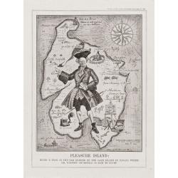
Pleasure Island.
Pleasure Island: Being A Plan in the Old Manner of the Lake Island in Canada which Mr Winston Churchill is said to covert.From Punch, September 11th 1929. An amusing map ...
Date: London, 1929
Selling price: ????
Please login to see price!
Sold in 2012
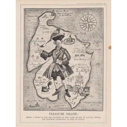
Pleasure Island.
Pleasure Island: Being A Plan in the Old Manner of the Lake Island in Canada which Mr Winston Churchill is said to covert.
Date: London, 1929
Selling price: ????
Please login to see price!
Sold in 2017
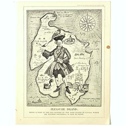
Pleasure Island : Being A Plan in the Old Manner of the Lake Island in Canada which Mr Winston Churchill is said to covert.
From Punch, September 11th, 1929.A satirical map attacking Churchill in his "Wilderness Years." In May of 1929, the Conservative government failed to gain reele...
Date: London, 1929
Selling price: ????
Please login to see price!
Sold in 2019
![Le voyage du missionnaire. [board game]](/uploads/cache/37521-250x250.jpg)
Le voyage du missionnaire. [board game]
A Goose game board with in four corner missionary scenes in the four continents and in center "N°. 60 Arrivée à la Mission florisante", with Asians people he...
Date: Vanves (France), ca. 1930
Selling price: ????
Please login to see price!
Sold in 2019
The Stock Exchange London 1933.
A beautiful and whimsical map, chock full of delightful small caricature vignettes, humorously depicting the 'goings on' in the financial market in London's City of Londo...
Date: London=, 1933
Selling price: ????
Please login to see price!
Sold in 2022
![Entrée de la Mer Adriatique.. [2662]](/uploads/cache/23488-250x250.jpg)
Entrée de la Mer Adriatique.. [2662]
Large chart centered on the Strait of Otranto and illustrating the Salento peninsula at the Italian side as well as the northwestern coast of Albania and the northwest mo...
Date: Paris [1886] corrected for 1935
Selling price: ????
Please login to see price!
Sold in 2023
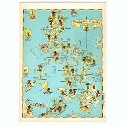
Philippines Islands.
Pictorial map of Philippines Islands, from the famous illustrator, Ruth Taylor White and published in "Our USA: A Gay Geography".Ruth Taylor White was among the...
Date: Boston, Little, Brown and Company, 1935
Selling price: ????
Please login to see price!
Sold in 2018

Carriers of the New Black Plague.
A powerful satirical commentary on totalitarian control of speech from the first issue of Ken Magazine. "Caught here in all their peculiar beauty by the soul searchi...
Date: Chicago, 1938
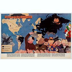
Carriers of the New Black Plague.
A powerful satirical commentary on totalitarian control of speech from the first issue of Ken Magazine. "Caught here in all their peculiar beauty by the soul searchi...
Date: USA, 1938
Selling price: ????
Please login to see price!
Sold in 2021
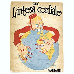
L'Intesa Cordiale.
Cover for an Italian caricature book cover, from 1940 by Enrico Gianeri (Gec). "Gec L’INTESA CORDIALE". Signed and dated on the stone lower right.
Date: Milan, 1940
Selling price: ????
Please login to see price!
Sold in 2020
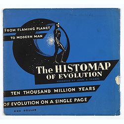
The Histomap of Evolution.
To make evolution more easy to understand, and facilitate a life to students - John B. Sparks, who created the Histomap of religion and Histomap of world history, also cr...
Date: Chicago, 1942
Selling price: ????
Please login to see price!
Sold in 2018
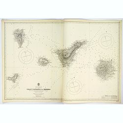
Gran Canaria to Hierro.
A very large double sheet sea chart of Gran Canaria to Hierro in the Canary Islands, originally surveyed by Capt. A.T.E. Vidal and Lieut. W. Arlett, R.N. between 1834-183...
Date: London, 1942
Selling price: ????
Please login to see price!
Sold in 2023
![[Phuket - Harbour]](/uploads/cache/48535-250x250.jpg)
[Phuket - Harbour]
Scarce Japanese chart of Phuket prepared by Daisuke Soejima Daikin and probably the first detailed chart of the region made just after the capture of Thailand by the Japa...
Date: Japan, August 1942
Selling price: ????
Please login to see price!
Sold in 2023
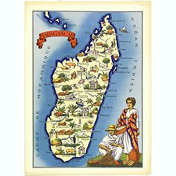
Madagascar.
Very decorative, informative map of Madagascar. The map is filled with buildings, animals, figures and two locals in their typical dress.In lower left corner "Imprim...
Date: France, 1943
Selling price: ????
Please login to see price!
Sold in 2018
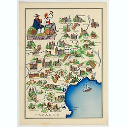
Languedoc - Foix Roussillon.
This is a very decorative, informative map of the Languedoc - Foix Roussillon region in southeastern France, including the towns of Carcassonne, Montpellier,, Albi, Toulo...
Date: France, 1943
Selling price: ????
Please login to see price!
Sold in 2023
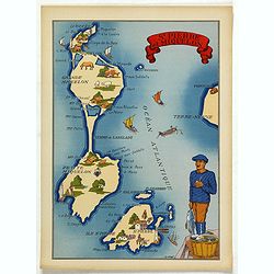
St. Pierre et Miquelon.
In the lower left corner, "Imprimé en France" with a monogram of the publisher "BD". The map carries the printed signature of the French illustrator...
Date: France, 1943
Selling price: ????
Please login to see price!
Sold in 2025
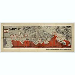
Wacht am Rhein.
Map depicting the German, Dutch, French border line. Design by Robert Macfarlane Chapin Jr.. In left hand side : Enlargement of original map drawn for TIME The Weekly New...
Date: New York , Time Magazine, 1944
Selling price: ????
Please login to see price!
Sold in 2017
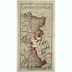
Counter attack.
Map depicting the German, Dutch, French border line. Design by Robert Macfarlane Chapin Jr.. In left hand side : Enlargement of original map drawn for TIME The Weekly New...
Date: New York , Time Magazine, 1945
Selling price: ????
Please login to see price!
Sold in 2017
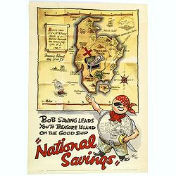
National Savings.
An English National Savings advertising poster, issued just after the second world war. Shows a mythical island treasure map with a slogan underneath extolling the virtue...
Date: London, 1946
Selling price: ????
Please login to see price!
Sold in 2016
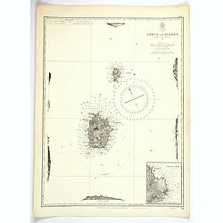
Azores. Corvo and Flores.
A large updated British Sea Chart from an original survey undertaken by Capt. A.T.E. Vidal, R.N. in 1844 of the islands of Corvo and Flores in the Azores Archipelago in t...
Date: London, 1946
Selling price: ????
Please login to see price!
Sold in 2023

The Mapmaker.
Satirical condemnation of the Axis leaders by a Polish-Jewish cartoonist.Issued in a 1942 edition of Esquire Magazine, this image by the talented artist Arthur Szyk shows...
Date: London, 1948
Selling price: ????
Please login to see price!
Sold in 2021
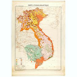
Carte de l'Indochine au 1 : 2.000.000. Carte ethnolinguistique.
Map showing Vietnam, Cambodia, and Laos, prepared under the direction of "l'Ecole Française d'Extrême-Orient". Relief shown by spot heights. With a colored ke...
Date: Hanoï, 1949
Selling price: ????
Please login to see price!
Sold in 2025
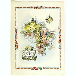
Afrique.
color printed pictorial map of Africa, with decorative title cartouche and borders, depict countries, regions, major cities, animals and wildlife. Includes decorative com...
Date: Paris, 1951
Selling price: ????
Please login to see price!
Sold in 2018
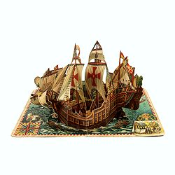
Christoph Columbus Genuensis and Santa Maria.
This is the rare 1960's original Artia Prague pop up children's pop up book of the Columbus ship the Santa Maria, design by the artist Vojtech Kubašta.When opened: 325...
Date: Prague, 1960
Selling price: ????
Please login to see price!
Sold in 2021
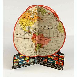
Four sides advertising globe for Incal-Flex.
Advertising for Calzado Counter INCAL-FLEX by FUNSA of Uruguay. This two piece advertising object opens to form a terrestrial globe. It was mend to be placed on the resel...
Date: Uruguay, ca. 1965
Selling price: ????
Please login to see price!
Sold in 2020
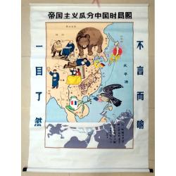
Map of the Imperialist Division of China
Unusual, large silkscreened map of China based on the serio-comic map drawn in 1899 by Tse Tsan-tai, Chinese patriot and co-founder of Hong Kong's South China Morning Po...
Date: China, C. 1960-1980
Selling price: ????
Please login to see price!
Sold in 2023
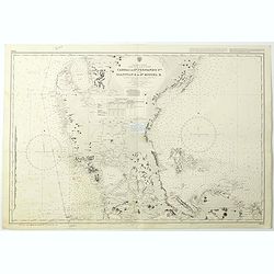
Philippine Islands - Luzon - west and east coast. Cabra I. to S.n Fernando P.t. Diapitan B. to S.n Miguel B. . . (3806)
Detailed chart of Luzon Island with Manila Bay, Cabra Island to S. Fernando Point Diapitan Bay to S. Miguel Bay.A highly corrected version of Admiralty chart 3806 origina...
Date: London, 1922 / 2006
Selling price: ????
Please login to see price!
Sold in 2018
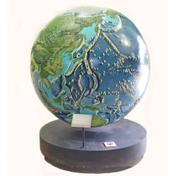
A unique 78 inches (2 meters) diameter relief globe shows the physical features under the oceans.
This unique relief globe with a diameter of 2 meters (78.7 inches) and an overall height, including a frame, of 235 cm (92.5 inches) shows the physical features under the...
Date: Sydney, 1972, 2012
Selling price: ????
Please login to see price!
Sold in 2022
![INFLUENCE DE L'INFLUENZA SUR L'EUROPE. [The influence of Flu on Europe]](/uploads/cache/84679-250x250.jpg)
INFLUENCE DE L'INFLUENZA SUR L'EUROPE. [The influence of Flu on Europe]
A 1890's rare chromolithographed humouristic map on a flu pandemic in Europe. Published by the French satiric paper 'Le Troupier' in Paris.The largest nineteenth-century ...
Date: Paris, ca 1890
Selling price: ????
Please login to see price!
Sold in 2020