Browse Listings in Map Types > Pictorial & Advertising
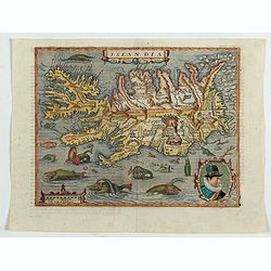
Islandia.
Quad's : reduced in size Ortelius´ map, of Iceland. With German text on verso, from Geographisch Handtbuch. Signed by the engraver Johan Bussemacher.Matthias Quad was o...
Date: Cologne, 1600
Selling price: ????
Please login to see price!
Sold in 2023
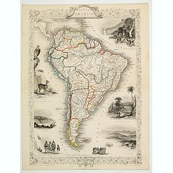
South America.
This is John Tallis’ pretty map of South America. The map is surrounded by a number of topical steel engraved vignettes and the whole is surrounded by a decorative vine...
Date: London, 1851
Selling price: ????
Please login to see price!
Sold in 2023
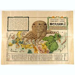
A Humorous Diplomatic Atlas of Europe and Asia. / 滑稽欧亜外交地図 / Kokkei Ō-A Gaikō Chizu.
A wonderful example of the rare 1904 Kisaburo Ohara satirical 'Octopus Map' of Europe being swallowed by an octopus (Russia). Composed at the outbreak of the Russo-Japane...
Date: Tokyo, April, 1904
Selling price: ????
Please login to see price!
Sold in 2023
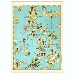
Philippines Islands.
Pictorial map of Philippines Islands, from the famous illustrator, Ruth Taylor White and published in "Our USA: A Gay Geography".Ruth Taylor White was among the...
Date: Boston, Little, Brown and Company, 1935
Selling price: ????
Please login to see price!
Sold in 2018
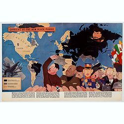
Carriers of the New Black Plague.
A powerful satirical commentary on totalitarian control of speech from the first issue of Ken Magazine. "Caught here in all their peculiar beauty by the soul searchi...
Date: USA, 1938
Selling price: ????
Please login to see price!
Sold in 2021
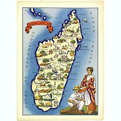
Madagascar.
Very decorative, informative map of Madagascar. The map is filled with buildings, animals, figures and two locals in their typical dress.In lower left corner "Imprim...
Date: France, 1943
Selling price: ????
Please login to see price!
Sold in 2018
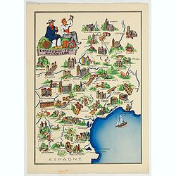
Languedoc - Foix Roussillon.
This is a very decorative, informative map of the Languedoc - Foix Roussillon region in southeastern France, including the towns of Carcassonne, Montpellier,, Albi, Toulo...
Date: France, 1943
Selling price: ????
Please login to see price!
Sold in 2023
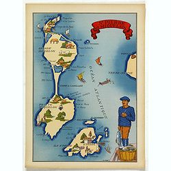
St. Pierre et Miquelon.
In the lower left corner, "Imprimé en France" with a monogram of the publisher "BD". The map carries the printed signature of the French illustrator...
Date: France, 1943
Selling price: ????
Please login to see price!
Sold in 2025
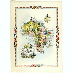
Afrique.
color printed pictorial map of Africa, with decorative title cartouche and borders, depict countries, regions, major cities, animals and wildlife. Includes decorative com...
Date: Paris, 1951
Selling price: ????
Please login to see price!
Sold in 2018
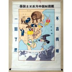
Map of the Imperialist Division of China
Unusual, large silkscreened map of China based on the serio-comic map drawn in 1899 by Tse Tsan-tai, Chinese patriot and co-founder of Hong Kong's South China Morning Po...
Date: China, C. 1960-1980
Selling price: ????
Please login to see price!
Sold in 2023
