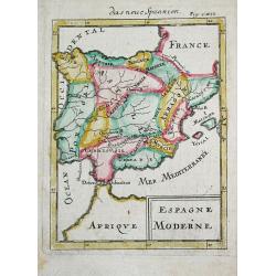
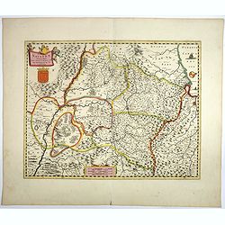
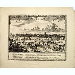
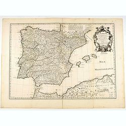
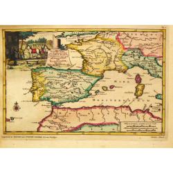
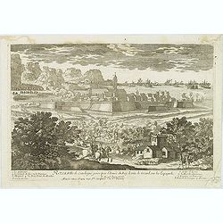
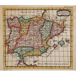
Espagne Moderne.
Alain Manneson Mallet (1603-1706) published in 1683 his ' Description de l' Univers' in 5 volumes. In 1686 a German edition appeared.A map from Alain Manesson Mallet's 'D...
Date: Paris, 1686
Selling price: ????
Please login to see price!
Sold in 2019
-250x250.JPG)
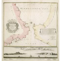
Insulae Canariae alias Fortunatae
A 17th century copper-engraved map (nautical chart) of the Canary Islands and Madeira, from a French edition of Olfert Dapper's ´Naukeurige Beschrijvinge der Afrikaensch...
Date: Amsterdam, 1686
Selling price: ????
Please login to see price!
Sold in 2023
![[ Spain and Portugal ]](/uploads/cache/30318-250x250.jpg)
[ Spain and Portugal ]
Charming wood block map of Spain and Portugal by the Italian XVIth and XVIIth century writer, humanist and cartographer Giuseppe Rosaccio. Taken from the 1688 Bologna &qu...
Date: Bologna, Antonio Pisarri, 1594 - 1688
Selling price: ????
Please login to see price!
Sold in 2014
La spargna...
Fine map engraved by Giorgio Widman. Giacomo Rossi's fine late 17th century map of Spain and Portugal. Issued in Il Mercurio geografico In lower right hand corner large t...
Date: Rome, 1677-1688
Selling price: ????
Please login to see price!
Sold in 2015

Le Chateau Royal de Madrid.
Highly detailed, hand-colored copper engraving of the royal palace in Spain. By the Perelle family of France. From "Vues de France" published in 1689.
Date: Paris, 1689
Selling price: ????
Please login to see price!
Sold in 2017
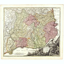
Novissima Arragoniae regni tabula.
Shows cities of Saragossa and Pamplona.
Date: Amsterdam, 1690
Selling price: ????
Please login to see price!
Sold in 2010
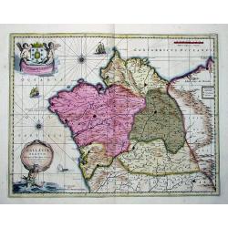
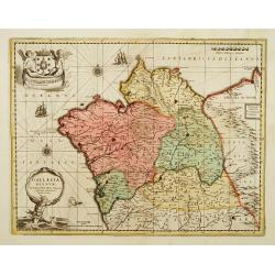
GALLAECIA REGNUM, descripta a F. Fer.
Beautiful double-page copper engraved map of Galicia. By Valk and Schenk after Ferdinand Ajea. Extending from the Asturias de Oviedo region and Aviles in the Northeast to...
Date: Amsterdam, ca. 1690
Selling price: ????
Please login to see price!
Sold in 2011
Regni Navarrae. . .
Centred on Pamplona. Orientated west to the top.
Date: Amsterdam, 1690
Selling price: ????
Please login to see price!
Sold in 2018

Carel de 2 door G. G Koning van Spangien.
Equestrian portrait of Carel de 2nd, full-length in profile to left but looking at the viewer, horse seen in frontal view, after Pieter Stevens ( c.1683-1692).This is one...
Date: Antwerp, c.1690
Selling price: ????
Please login to see price!
Sold in 2019
![[6 sheets] Principaute De Catalogne. Ou sont compris Les Comtes de Roussillon et de Cerdagne divises en leurs Vigueries (Map and 5 sheets, with 32 additional Catalan Cities Plans and Table of Names,rare complete set in first edition!)](/uploads/cache/84497-250x250.jpg)
[6 sheets] Principaute De Catalogne. Ou sont compris Les Comtes de Roussillon et de Cerdagne divises en leurs Vigueries (Map and 5 sheets, with 32 additional Catalan Cities Plans and Table of Names,rare complete set in first edition!)
Principaute De Catalogne. Ou sont compris Les Comtes de Roussillon et de Cerdagne divises en leurs Vigueries. A striking large and highly detailed map of Catalonia, with ...
Date: Paris, 1692
Selling price: ????
Please login to see price!
Sold in 2020
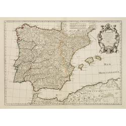
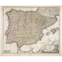
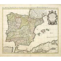
L\'Espagne divisée en tous ses Royaumes et Principautées. . .
RARE state with erased date but still with Jaillot's name in the dedication followed by his title as royal geographer. With address "Chéz H.Jaillot, joignantles gra...
Date: Paris, after 1695
Selling price: ????
Please login to see price!
Sold in 2011
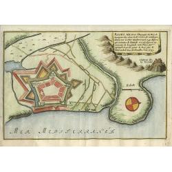
Roses.
Nice city plan of Roses in Spain.
Date: Paris 1696
Selling price: ????
Please login to see price!
Sold
L'Espagne divisée en Galice Asturies Biscaye . . .
An interesting small map of Spain and Portugal by Nicolas de Fer. From his rare "Petit et Nouveau Atlas". The first edition was published in 1697 and was republ...
Date: Paris, 1697
Selling price: ????
Please login to see price!
Sold in 2017
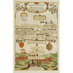
Reges Arpag Veteres..
A family tree of the rulers of Aragon starting with Ennicus (832-861). In lower part a view of Burgos.
Date: England, 1700
Selling price: ????
Please login to see price!
Sold

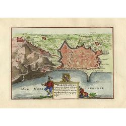
Barcellona.
A page of printed text in German with an engraving of an attack on the city of Barcelona.
Date: Germany, ca.1700
Selling price: ????
Please login to see price!
Sold in 2009
Theatre de la Guerre en Espagne et en Portugal.
A exceptional detailed wall map of Spain and Portugal with a huge beautiful designed title cartouche. Printed from 4 plates, two each already joined. Size of both sheets ...
Date: Amsterdam, 1700
Selling price: ????
Please login to see price!
Sold in 2010
La Espana Dedicata all Ill Ed Ecc Sig. D. Carmine Niccolo Caracciolo. . .
Rare map of Spain and Portugal. Engraved by Andrea Magliar and published by Paolo Petrini. Based on a map of Nicholas De Fer.This is the first edition of the map, which i...
Date: Naples, 1700
Selling price: ????
Please login to see price!
Sold in 2013
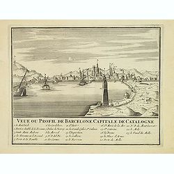
Veue ou Profil de Barcelone Capitale de Catalogne.
Panoramic view of Barcelona, with 23-point key.
Date: Paris, ca. 1700
Selling price: ????
Please login to see price!
Sold
Sivillia.
A lovely large, decorative town view on the Andalusian capital city of Seville, by F. de Witt. With imposing and important buildings identified, the river Guadalquivir is...
Date: Amsterdam, ca 1700
Selling price: ????
Please login to see price!
Sold in 2017
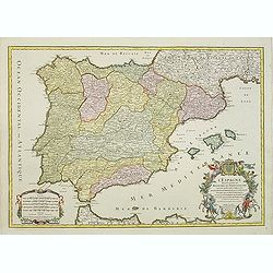
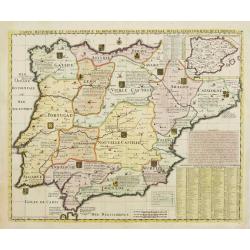
L'Espagne.
Beautiful map showing Spain and Portugal, the different Provinces ( Castille, Aragon, Andalousia..) and the North African coast. Decorative title cartouche.
Date: Paris, 1701
Selling price: ????
Please login to see price!
Sold
L'Espagne, dresse fur la Description qui en a ete faite par Rodrigo Mendez Sylva. . .
Finely detailed map Spain by Guillaume de L'Isle. Shows cities, villages, mountains and rivers. Also shown are the islands of Minorca, Mallorca and Ibiza and well as the ...
Date: Paris, 1701
Selling price: ????
Please login to see price!
Sold in 2010
Espagne et Portugal.
Small scale, detailed map of Portugal and Spain by French cartographer Nicholas de Fer. A decorative title cartouche is at the top right, and a small distance key is at t...
Date: Paris, 1701
Selling price: ????
Please login to see price!
Sold in 2010
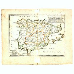
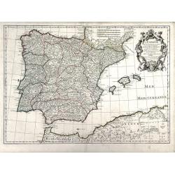
L'Espagne . . .
Detailed map showing Spain and Portugal, the different Provinces ( Castille, Aragon, Andalousia..) and the North African coast. Decorative title cartouche.The rare Amster...
Date: Amsterdam, ca. 1701
Selling price: ????
Please login to see price!
Sold in 2022
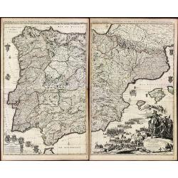
![[Lot of 5 maps of the Iberian peninsula / Belearics]](/uploads/cache/18379-(2)-250x250.jpg)
[Lot of 5 maps of the Iberian peninsula / Belearics]
Guillaume de l' Isle (1675-1724), Royal Geographer, was the most influential cartographer of the first quarter of the 18th century. ' Atlas de Géographie' (1700-12), pos...
Date: 1701
Selling price: ????
Please login to see price!
Sold in 2022
Die Süd-West Cüste von Gallicien.
Very decorative map from Bodenehr's "Atlas curieux" published in Augsburg. The detailed map shows the area around Vigo in Gallicia in north-west Spain and inclu...
Date: Augsburg, c1704
Selling price: ????
Please login to see price!
Sold
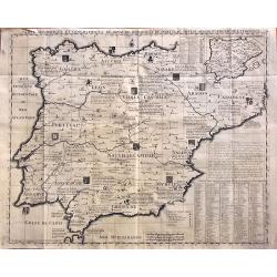
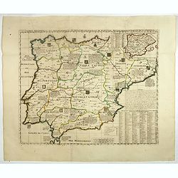
A New Map of Present Spain & Portugal, Shewing Their Principal Divisions, Chief Cities, Townes, Ports, Rivers, Mountains & c. Dedicated to his Highness, William, Duke of Gloucester
Drawn by Edward Wells and engraved by R. Spofforth. An attractive and decorative early map of Spain & Portugal from the beginning of the 18th Century.This map was pa...
Date: London, 1704
Selling price: ????
Please login to see price!
Sold in 2015
Royaume de Galice province d''Espagne. / Port et rade de Vigo.
Copper engraving by G. Inselin for Nicolas De Fer (1646-1720). Map is dated 1705. Three maps on one sheet. The left map reaches as far south as Caminha on the Miño river...
Date: Paris, 1705
Selling price: ????
Please login to see price!
Sold in 2008
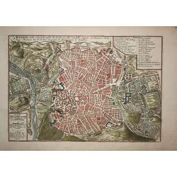
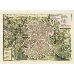
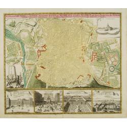
Madrid
A city plan of Madrid with the surroundings. The map has a lot of details, like fields, trees, main buildings and defence walls.
Date: Paris, 1705
Selling price: ????
Please login to see price!
Sold in 2009
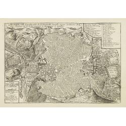
Madrid, Ville Considerable de la Nouvelle Castille, Sejour ordinaire des Roys d'Espagne. Par N. de Fer Geographe de Monseigneur le Dauphin.
Map of the city of Madrid, with a key: 1-26 in upper right corner. The city plan shows the geometric plant of the city, emphasizing the enclosure of old Villa and the Gre...
Date: Paris, 1705
Selling price: ????
Please login to see price!
Sold in 2009
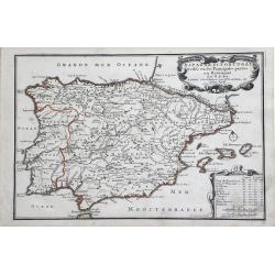
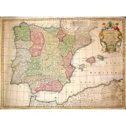
L'Espagne divisée en tous ses royaumes et Principautés. . .et sous la couronne de Portugal. . .
Very large map of Spain and Portugal, including the Balearic Islands Majorca, Minorca and Ibiza, ornated with a rococo title cartouche. A first state, without with lines ...
Date: Amsterdam, c.1705
Selling price: ????
Please login to see price!
Sold in 2011
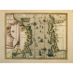
Coste d Andalousie et D álgarve
Nice map of the street of Gibraltar with Gibraltar at left and the African coast at right with the cities Ceuta (Spain) and Tanger (Marocco).The map has an inset at left ...
Date: Paris, 1705
Selling price: ????
Please login to see price!
Sold in 2009
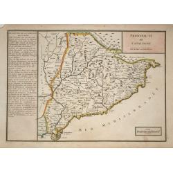
Principaute de Catalogne
A simply engraved map of the Spanish region of Catalonia depicting the Mediterranean coastline from the French border near Cadaques, southwest through Barcelona to the de...
Date: Paris, 1705
Selling price: ????
Please login to see price!
Sold in 2009
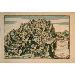
Maison et chambre .. Mont Serrat..Barcelone.
Nice view at the mountain Mont-Serrat close to Barcelona.
Date: Paris, 1705
Selling price: ????
Please login to see price!
Sold in 2009
La Castille Vieiele et Nouvelle L'Estramadura De Castille Et De Leon. . .
Beautiful, detailed map of the Leon and Castille regions of Spain by Nicholas de Fer. The cities of Madrid and Toledo are depicted, as well as the mountains, forests, riv...
Date: Paris, 1706
Selling price: ????
Please login to see price!
Sold in 2010
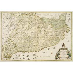
La Catalogne Dédiée au Roy..
A scarce map of Catalonia showing the coastline from Perpignan until the province of Valencia. Extensive shipping and a large title cartouche.Published by Mademoiselle Du...
Date: Paris, 1707
Selling price: ????
Please login to see price!
Sold
Reys-Weg uit Brabant?Spanje en Portugal.
Pieter van der Aa was a prolific publisher. He published a.o. ' Naauwkeurge versameling der gedenkwaardigste zee- en land-reysen', a series of accounts of voyages (1706-0...
Date: Leiden, 1707
Selling price: ????
Please login to see price!
Sold in 2016
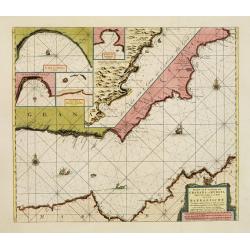
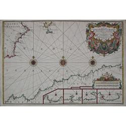
Pascaart van de Zee Kusten van Granada en Murcia.. Barbarische Zee-Kusten..
This sea chart covers the Spanish coast from Véléz-Malaga, in the region Andalucía, from Malaga as far as Alicante and Bay of Altea, in the province of Valencia. It sh...
Date: Amsterdam, 1708
Selling price: ????
Please login to see price!
Sold
Barcelonne.
Nice little plan of Barcelona, with a nice cartouche with coat of arms.
Date: Amsterdam 1710
Selling price: ????
Please login to see price!
Sold
![Theatre de la Guerre en Espange et en Portugal. . . Presenté à Philippe V Roy d'Espagne, et de Indes. . . [four sheets]](/uploads/cache/01579-250x250.jpg)
Theatre de la Guerre en Espange et en Portugal. . . Presenté à Philippe V Roy d'Espagne, et de Indes. . . [four sheets]
The map is exceptionally detailed, but the most remarkable feature of the engraving is the enormous, superbly detailed and designed title-piece. A dedication to Philip V ...
Date: Amsterdam, 1710
Selling price: ????
Please login to see price!
Sold in 2009
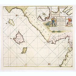
Paskaart van de Zee-kusten van Valence Catalonien Languedocq. . .
Fine sea chart showing the coast of Valencia, Catalonia, Languedoc, and Provence, and the islands of Majorca, Minorca and Ibiza.Title flanked by figures, topped by inset ...
Date: Amsterdam, c.1710
Selling price: ????
Please login to see price!
Sold in 2013
Principatus Cataloniae nec non Comitatum. . .
Detailed map centered on Catalonia. Lower right splendid title cartouche.Maps published in Germany during the 18th century are usually in body colors, with uncolored cart...
Date: Nurenberg, 1710
Selling price: ????
Please login to see price!
Sold in 2016
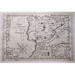
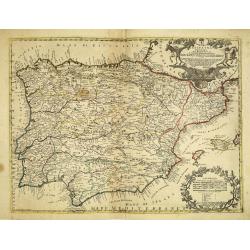
Tabula totius Hispaniae.
Scarce map extending from Madeira and Lanzarote, to the border of France. Published in Montecalerio's "Chorographica descriptio Provinciarum et Conventuum Fratrum mi...
Date: Rome, 1643-1712
Selling price: ????
Please login to see price!
Sold in 2016
Madrid, ville Considerable de la Nouvelle Castille. . .
Plan of Madrid engraved by C Inselin, stretching from Westminster Abbey in the west to Mile End in the east. A 26 point key identifies important landmarks.From De Fer's &...
Date: Paris, 1717
Selling price: ????
Please login to see price!
Sold in 2011
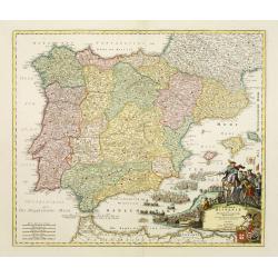
Carte Historique Et Geographique Des Royaumes D Espagne Et De Portugal Divises Selon Leurs Royaume et Provinces
Very detailed map of Spain and Portugal. Coats of arms and substantial details throughout the regions are delineated.From Chatelain's monumental Atlas Historique (in 7 vo...
Date: Amsterdam, 1719
Selling price: ????
Please login to see price!
Sold in 2014
Gallaecia Regnum.
Fine map of part of Spain.
Date: Amsterdam, 1720
Selling price: ????
Please login to see price!
Sold
Carte Historique et Geographique des Royaumes d'Espagne et de Portugal..
Historical and geographical map of the kingdoms of Spain and Portugal divided according to their kingdoms and provinces. Including indexes, notes and an inset map of the ...
Date: Amsterdam, ca. 1720
Selling price: ????
Please login to see price!
Sold

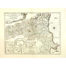
Carte du Gouvernement de la Cour d'Espagne..
This impressive engraving is a wonderful example of Chatelain's elegant plates. Ornamented with numerous vignettes.It provides a detailed description of the infrastructur...
Date: Amsterdam, ca. 1720
Selling price: ????
Please login to see price!
Sold in 2012

Hispaniae et Portugalliae regna per Nicolaum Visscher
Outstanding example of an Iberian peninsula map showing Spain and Portugal and Balearic Islands. Two beautiful cartouches with several putti and coat of arms. Published b...
Date: Amsterdam, 1720
Selling price: ????
Please login to see price!
Sold in 2009
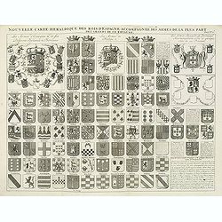
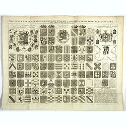
Nouvelle carte héraldique des rois d'Espagne accompagnée des armes . . .
Decorative sheet with coats of arms of Spanish and Portuguese Kings and noble families. This impressive engraving is a wonderful example of Chatelain’s elegant plates f...
Date: Amsterdam, ca. 1720
Selling price: ????
Please login to see price!
Sold in 2012
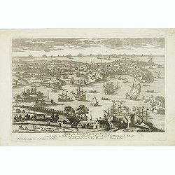
Veue de la Ville de Cadix en Espagne. . .
A very RARE panoramic of the city of Cadiz.Engraved by Pierre Aveline (Paris, c.1656 - 23 May 1722). He was also a print-publisher and print-seller. He probably trained ...
Date: Paris, 1690-1720
Selling price: ????
Please login to see price!
Sold in 2012
Rozes, Ville de Catalogne par l'Armée du Roy Louis le Grand sur les Espagnols.
A very RARE panoramic of the city of Rozes.Engraved by Pierre Aveline (Paris, c.1656 - 23 May 1722). He was also a print-publisher and print-seller. He probably trained ...
Date: Paris, 1690-1720
Selling price: ????
Please login to see price!
Sold
Hispaniarum Portugalliae que coronarum..
Detailed map of Spain and Portugal with large uncolored title cartouche.
Date: Amsterdam, 1720
Selling price: ????
Please login to see price!
Sold in 2025
Hispania ex Archetypo Roderici Mendez Sylvae.
Striking copperplate map of Spain & Portugal. Decorative allegorical cartouche with an older man's head and two white horses. The Lotter family were engravers and pub...
Date: Augsburg, 1720
Selling price: ????
Please login to see price!
Sold in 2014
Carte généalogique des rois de Navarre de Castille d'Arragon de Portugal et de Grenade, rangée en parallele avec la carte d'Espagne qui distingue les diverses situations de leurs états, leurs armes et alliances.
Interesting sheet with a map of Spain and Portugal and a genealogical tree of the kings of Castile and Navarre, with descriptive French text, from Chatelain's monumental ...
Date: Amsterdam, 1720
Selling price: ????
Please login to see price!
Sold in 2014
Nouvelle carte heraldique des rois d'Espagne . . .
Decorative sheet with coats of arms of Spanish and Portuguese Kings and noble families.From Chatelain's monumental 7 volume "Atlas Historique".Henri Abraham Cha...
Date: Amsterdam, 1720
Selling price: ????
Please login to see price!
Sold in 2018
Carte Historique et Geographique des Royaumes d'Espagne et de Portugal..
Historical and geographical map of the kingdoms of Spain and Portugal divided according to their kingdoms and provinces. Including indexes, notes and an inset map of the ...
Date: Amsterdam, ca. 1720
Selling price: ????
Please login to see price!
Sold in 2018

Carte Genealogique de la Maison Imperiale d'Autriche & les Differentes Branches qu'elle a Formees Accompagnee des Trophees des Armes Imperiales & d'Espagne ...
An engraved genealogical family tree of Imperial Austria illustrating its links with the Spanish royal family. Their respective arms dominate the plate with views of the ...
Date: Amsterdam, ca. 1720
Selling price: ????
Please login to see price!
Sold in 2018

Carte généalogique des rois de Navarre de Castille d'Arragon de Portugal et de Grenade, rangée en parallele avec la carte d'Espagne qui distingue les diverses situations de leurs états, leurs armes et alliances.
Interesting sheet with a map of Spain and Portugal and a genealogical tree of the kings of Castile and Navarre, with descriptive French text, from Chatelain's monumental ...
Date: Amsterdam, 1720
Selling price: ????
Please login to see price!
Sold in 2019
![[Spain & Portugal] Hispania ex Archetypo Roderici Mendez Sylvae et variis Relationibus et Chartis manuscriptis et impressis huius Regni rectificatis per Observationes Sociorum Academiae Scientiarum quae est Parisiis.](/uploads/cache/1151518-250x250.jpg)
[Spain & Portugal] Hispania ex Archetypo Roderici Mendez Sylvae et variis Relationibus et Chartis manuscriptis et impressis huius Regni rectificatis per Observationes Sociorum Academiae Scientiarum quae est Parisiis.
Engraved map with original hand coloring 49.5 x 57 cm. (sheet size 53 x 62 cm.).
Date: Augsburg, 1720
Selling price: ????
Please login to see price!
Sold in 2020
Espagne.
A nice little map of Spain,
Date: Amsterdam, 1721
Selling price: ????
Please login to see price!
Sold
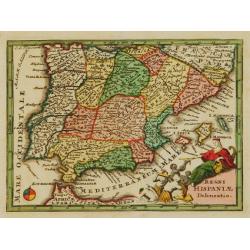
Regni Hispaniae Delineatio.
Uncommon map of Spain. The originally colored title cartouche is surrounded by mythological figures. From Atlas Portatif.
Date: Nuremberg 1724
Selling price: ????
Please login to see price!
Sold
Nieuwe Paskaart vant Naauw van de Straat. op gedragen aan den Hoog Edel geboren Heer F. Van Aerssen Van Sommelsduk
This is a scarce and well designed sea chart of the Strait of Gibraltar, oriented east with Spain on the left and the Barbary Coast (present-day Morocco) on the right. Th...
Date: Amsterdam 1726
Selling price: ????
Please login to see price!
Sold in 2023
Accurater grundris der .. Spanischen Haupt und Residentz stadt MADRIT ..
This plan of Madrid is richly ornated by various garden scenes, as well below with four views, among them we find the Royal Residence, Aranjuez and the Place Major.
Date: Nuremberg 1727
Selling price: ????
Please login to see price!
Sold
Nieuwe Paskaart van t Naauw van de Straat. . . F.van Aerssen van Sommelsdyk, de plaat bommel en Spyk. . . Hendrik Lynslager. . . 1726.
Chart of the entrance of the Mediterranean overlooking the Strait of Gibraltar. Based on the charts by Hendrik Lynslager, a Dutch navigator, this interesting sea chart de...
Date: Amsterdam, ca. 1727
Selling price: ????
Please login to see price!
Sold in 2013

Carte du Gouvernement Civil et Politique de l'Espagne . . .
This impressive engraving provides a detailed description of the infrastructure of the Spanish government. Ornamented with numerous vignettes illustrating sessions of par...
Date: Amsterdam, 1728
Selling price: ????
Please login to see price!
Sold in 2021
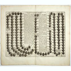
Carte cronologique et Historique pour servir a l'histoire d'Espagne.
This impressive engraving is a wonderful example of Chatelain’s elegant plates showing a genealogical chart and portraits of the kings of Spain and Portugal, from 406AD...
Date: Amsterdam, 1728
Selling price: ????
Please login to see price!
Sold in 2018
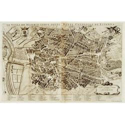
La villa de Madrid corte delos reyes catolicos de Espagne.
A beautifully engraved and richly detailed plan of Madrid. In bottom part a key to 67 principal spots in the town. Originally engraved for the rare town book of Frederick...
Date: Leiden 1729
Selling price: ????
Please login to see price!
Sold
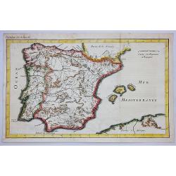
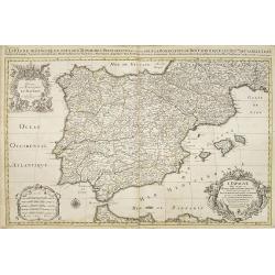
Carte du Royaume d'Espagne.
A striking map of Spain and Portugal. It is from METHODE POUR ETUDIER L’HISTOIRE by L’Abbe Lenglet du Fresnoy, published in Paris in 1729. The map is quite rare and i...
Date: Paris, 1729
Selling price: ????
Please login to see price!
Sold in 2020
Suite des Costes d?Espagne et Barbarie.
A chart showing the coast of Spain from Cartagena to Denia with Ibiza and Formentera and the coast of North Africa With 4 insets with coastal details and decorated with t...
Date: Paris, 1727-1730
Selling price: ????
Please login to see price!
Sold
Regnorum Hispaniae et Portugalliae tabula Generailis..
Fine map of Spain and Portugal, including Majorca and Minorca. Exceptionally detailed, but the most remarkable feature of the engraving is the large title-piece showing a...
Date: Nuremberg 1730
Selling price: ????
Please login to see price!
Sold
Nova Regni Hispaniae accurata descriptio ad u sum serenissimi Burgundiae ducis.
Prepared by G.de L'Isle.The Amsterdam publishing firm of Covens and Mortier (1721 – c. 1862) was the successor to the extensive publishing empire build by Frenchman Pie...
Date: Amsterdam, 1730
Selling price: ????
Please login to see price!
Sold in 2010
Le Roussillon Subdivisé en Cerdagne, Cap Sir, Conflans, Vals de Carol et de Spir ou se trouve encore le Lampourdan, Faisant Partie de la Catalogne.
Striking map of the region including part of the southeastern French Mediterranean coastline and neighboring Catalonia.This very decorative map includes in the lower left...
Date: Paris, 1730
Selling price: ????
Please login to see price!
Sold
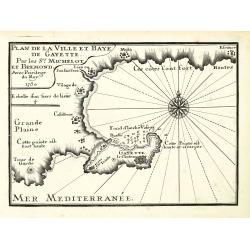
Plan de la Ville et Baye de Gayette.
An attractive chart centered on the Mediterranean. With scale and large compass-rose. Dated 1727, with the privilege of the King. From : Recueil des Plusieurs plans des p...
Date: Marseille, 1730
Selling price: ????
Please login to see price!
Sold in 2013
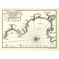
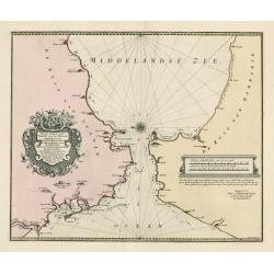
Plan de la Baye et Citadelle de Rose et de Tourrille.
An attractive chart centered on Tourrille and Roses in Catalonia. With scale and large compass-rose. Dated 1727, with the privilege of the King. From : Recueil des Plusie...
Date: Marseille, 1730
Selling price: ????
Please login to see price!
Sold in 2010
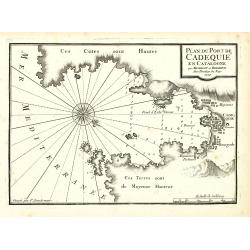
Plan du Port de Cadequié en Catalogne.
An attractive chart centered on the town and Bay of Cadequie or Cadaquez in Catalonia. With scale and large compass-rose. Dated 1727, with the privilege of the King. From...
Date: Marseille, 1730
Selling price: ????
Please login to see price!
Sold in 2010
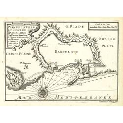
Plan de la Ville det Port de Barcelone.
An attractive chart centered Barcelona. With scale and large compass-rose. Dated 1727, with the privilege of the King. From : Recueil des Plusieurs plans des ports et rad...
Date: Marseille, 1730
Selling price: ????
Please login to see price!
Sold in 2010
Plan de la Baye et Rade de Cadis.
An attractive chart of Cadiz. With scale and large compass-rose. Dated 1730, with the privilege of the King. From : Recueil des Plusieurs plans des ports et rades de la M...
Date: Marseille, 1730
Selling price: ????
Please login to see price!
Sold in 2012
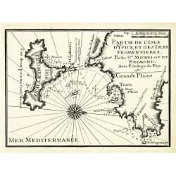
Partie de l'isle d'Yvice, et des isles fromentières.
An attractive chart centered on the south coasts of Ibiza and the Island of Formentera. With scale and large compass-rose. Dated 1730, with the privilege of the King. Fro...
Date: Marseille, 1730
Selling price: ????
Please login to see price!
Sold
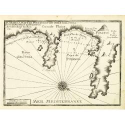
Plan de la Baye de Poyance et de celle d'Alcudia.
An attractive chart centered on the Mediterranean. With scale and large compass-rose. Dated 1727, with the privilege of the King. From : Recueil des Plusieurs plans des p...
Date: Marseille, 1730
Selling price: ????
Please login to see price!
Sold
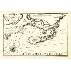
Plan de la Baye et Rades du Sofa.
An attractive chart centered on the Mediterranean. With scale and large compass-rose. Dated 1727, with the privilege of the King. From : Recueil des Plusieurs plans des p...
Date: Marseille, 1730
Selling price: ????
Please login to see price!
Sold in 2022
