Browse Listings in Europe > Eastern Europe > Eastern Europe
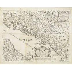
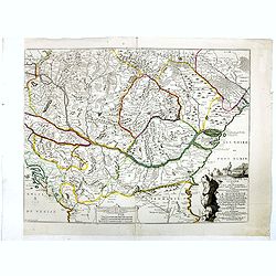
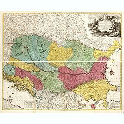
Dalmatia Istria Bosnia Servia Croatia parte di Schiavonia . . .
A late 17th century coast line map of Gulf of Venice and the Adriatic Sea in southern Central Europe bordering Italy to the west, the Adriatic Sea to the southwest, Croat...
Date: Rome, ca. 1692
Selling price: ????
Please login to see price!
Sold in 2009
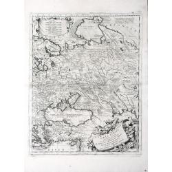
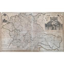
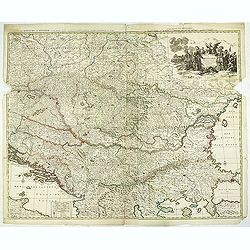
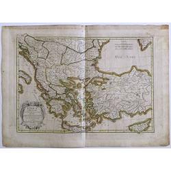
Parte Orientale Dell' Europa, Descritta, e Dedicata Dal P. Cosmografo Coronelli All Illustrissimo, et Eccellentissimo Signore Giovanni da Mula, Senatore amplissimo Nella Serenissima Republica de Venetia
Beautiful and finely detailed map including the regions of Eastern Europe, Russia, Turkey, the Caspian Sea and Nova Zembla by Vincenzo Coronelli and dedicated to Giovanni...
Date: Venice, 1692
Selling price: ????
Please login to see price!
Sold in 2010
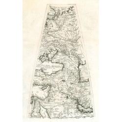
Gore sheet by Coronelli.
Gore sheet of eastern Europ and the Middle East for the big globe (110 cm in diameter) by Coronelli. Rare.
Date: Venice, 1690 - 1697
Selling price: ????
Please login to see price!
Sold in 2009
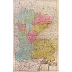
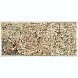
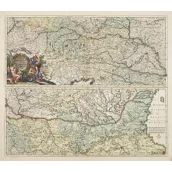
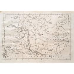
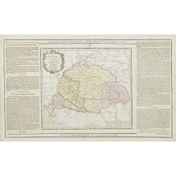
Theatre de la Guerre en Austriche, Baviere, Souabe, Le Tirol. Et le Pays aux Environs.
Colorful map of the Kingdom of Bohemia located in central Europe, present day-Czech Republic and Austria, until its dissolution in 1806. Different regions of Bohemia are ...
Date: Amsterdam, c. 1700
Selling price: ????
Please login to see price!
Sold in 2010
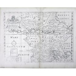
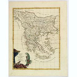
A New Map of Antient Thrace: as also Of the Northern Parts of Old Greece, Macedonia and Thessalia Dedicated to His Highness William Ducke of Glocester.
Map of Thrace, a historical and geographical region in Southeast Europe, currently the area of Northern Greece and Bulgaria, including parts of Macedonia and Thesalia (no...
Date: Oxford, c. 1700
Selling price: ????
Please login to see price!
Sold in 2010
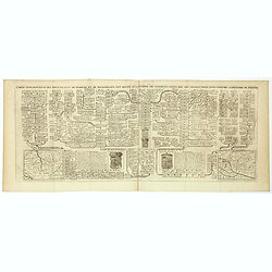
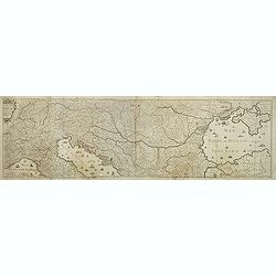
Exactissima totius danubii fluvii tabula et minores. . .
Showing the western part of the course of the River Danube. Including the towns of Heidelberg, Venice, Vienna, Budapest, etc. Published by Theodor Danckerts.The part has ...
Date: Amsterdam, 1700
Selling price: ????
Please login to see price!
Sold in 2013
![[Forteza di Catara]](/uploads/cache/36186-250x250.jpg)
[Forteza di Catara]
Uncommon print of the town of Kotor (citta di Cataro) in Montenegro.
Date: Italy, ca. 1700
Selling price: ????
Please login to see price!
Sold in 2016
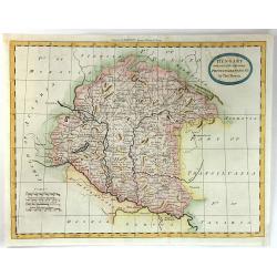
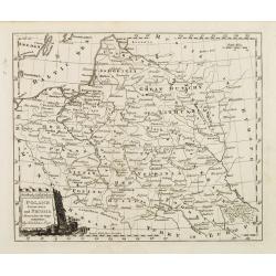
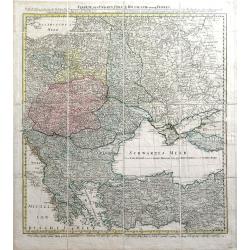
Carte de la Hongrie. . .
Finely detailed map of southeastern Europe, including the regions of Hungary, northern Greece, Bulgaria, Romania, Bohemia, Germany, Poland and the Ukraine by Guillaume de...
Date: Paris, 1703
Selling price: ????
Please login to see price!
Sold in 2010
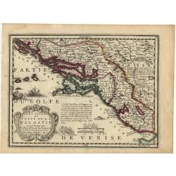
Les Isles et coste de la Dalmatie.
Nice small map of the Balkan coast.
Date: Paris, 1719
Selling price: ????
Please login to see price!
Sold
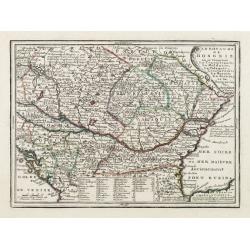
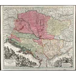
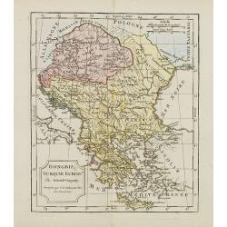
Le Royaume de Hongrie ou se trouvent La Transilvanie, La Moldavie, La Valaquie, L\'esclavonie, La Bosnie, La Servie, et la Bulgarie..
Map of Hungary including most part of southeastern Europe as far as Istanbul.It shows a text table at the bottom containing the names of Hungarian rulers.From Le Nouveau ...
Date: Paris, 1719
Selling price: ????
Please login to see price!
Sold in 2009
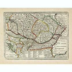
Le Royaume de Hongrie ou se trouvent La Transilvanie, La Moldavie, La Valaquie, L'esclavonie, La Bosnie, La Servie, et la Bulgarie..
Map of Hungary including most part of southeastern Europe as far as Istanbul.It shows a text table at the bottom containing the names of Hungarian rulers.From Le Nouveau ...
Date: Paris, 1719
Selling price: ????
Please login to see price!
Sold in 2016
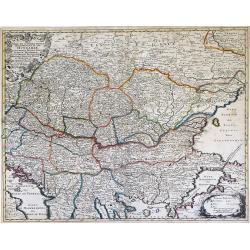
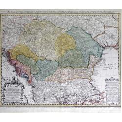
Nova et Accurata Tabula Regnorium Sup. Et Inf. Hungariae It: Sclavoniae, Bosniae, Serviae, Albaniae, Bessarable, ut et Princip. Transylvaniae, Moldavie, Walachiae, Bulgar et Romanie ...
Finely detailed map of Southeastern Europe showing the countries of Hungary, part of Ukraine, Romania, Bulgaria, northern Greece, Albania, Bosnia, Serbia, Croatia and the...
Date: Augsburg, c. 1720
Selling price: ????
Please login to see price!
Sold in 2010
Carte de etats de la dependance de sa maieste imperiale et des anciens comtes d'Habsbourg.
This impressive engraving is a wonderful example of Chatelain’s elegant plates from his "Atlas Historique, Ou Nouvelle Introduction A L’Histoire …" Showin...
Date: Amsterdam, ca. 1720
Selling price: ????
Please login to see price!
Sold in 2012
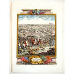
The Battle of Piterwaradin - August the V, 1716.
Antique hand-colored folio copper plate from Jean Dumont's book "The Military History of the Late Prince Eugene of Savoy and the Late John Duke of Marlborough"....
Date: London, 1727
Selling price: ????
Please login to see price!
Sold in 2015
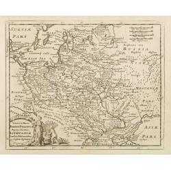
Veteris et Novae Regni Poloniae Magniq Ducatus Lithuaniae Cum Suis Palatinatibus ac Consinus Descriptio.
A simple map displays the region from the Baltic to the Black Sea, centered on Lithuania.It is filled with ancient place names. Presents a decorative title cartouche in t...
Date: Amsterdam, 1729
Selling price: ????
Please login to see price!
Sold in 2008
La Prusse. Suivant les Nouvelles Observations de Messrs. de l'Academie Royale des Sciences, etc. Augmentées de Nouveau. A Leide, chez Pierre vander Aa. - Avec Privilege.'
Decorative example of Van der Aa's map of Prussia, including Poland and Lithuania.
Date: Leiden, 1729
Selling price: ????
Please login to see price!
Sold in 2023
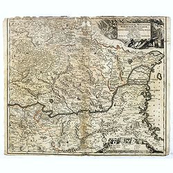
Transylvaniae, Moldaviae, Walachiae, Bulgariae nova et accurata Delineatio, Magnam Partem Hodierni Theatri Bellici ob oculos ponens opera et fumtibus .
Uncommon map showing Southeast Europe with Transylvania, Moldavia, Bulgaria and the Walachei. With the mouth of the river Danube into the Black Sea. In the upper right co...
Date: Nurember, 1730
Selling price: ????
Please login to see price!
Sold in 2016
A New Map of Germany, Hungary, Transilvania...
Large scale map of central Europe from Moll, published J. & T. Bowles, P. Overton & J. King. Shows the area within Danzig, Denmark, Paris, Venice, Trieste, Pragu...
Date: London, ca. 1730
Selling price: ????
Please login to see price!
Sold in 2023
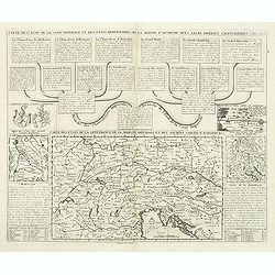
Carte genealogique des Ducs et Rois de Boheme et de Hongrie qui ont regné ou gouverné ces differents etats avec des instructions pour conduire à l'histoire de POLOGNE. . .
A genealogical tree of the Bohemian ducks and kings, from Chatelain's monumental 7 volume "Atlas Historique". This two sheet print features two maps (115 x 153m...
Date: Amsterdam, 1719-1732
Selling price: ????
Please login to see price!
Sold in 2017
Carte genealogique des Ducs et Rois de Boheme et de Hongrie qui ont regné ou gouverné ces differents etats avec des instructions pour conduire à l'histoire de POLOGNE. . .
A genealogical tree of the Bohemian Duchess and Kings, from Chatelain's monumental 7 volume "Atlas Historique". This two sheet print features two small maps (11...
Date: Amsterdam, 1719-1732
Selling price: ????
Please login to see price!
Sold in 2018
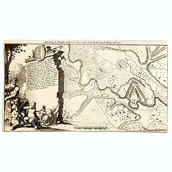
Afbeelding der Batallje tusschen de Moscoviters en de Turken aan de Rivier de Prut.
An attractive engraving showing the battle plan along the river Prut in Moldavie. Decorative lettered key A-R in left part.During the Russo-Turkish War of 1710–1711, on...
Date: Amsterdam, 1735
Selling price: ????
Please login to see price!
Sold in 2014
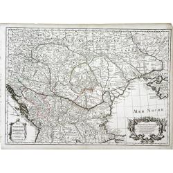
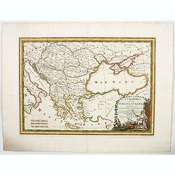
Le théâtre de la guerre sur les frontières des deux empires depuis Vienne jusques à Constantinople, où se trouvent la Hongrie, la Transilvanie,
Nicolas De Fer's map of the Theater of War showing the region between Vienna and Constantinople, included are Hungary, Bulgaria, Wallachia, Transylvania, Bosnia and Serbi...
Date: Paris, Bernard, 1737
Selling price: ????
Please login to see price!
Sold in 2019
Nova et Accurata Hungariae cum adiacentib. Regn. et Principatibus Tabula
Original old colored map of the Balkan by M. Seutter. Showing Hungary, Serbia, Croatia, Bosnia and Herzegovina and Albania. With two beautiful cartouches.
Date: Augsburg, 1740
Selling price: ????
Please login to see price!
Sold in 2009
Carte d'Hongrie en general contenant felon la Division ancienne & methodique, la Hongrie en particulier, la Croatie, la Dalmatie, la Bosnie, la Servie, la Boulgarie; la Principaute de Transylvanie, les Defpotats de Walacie & de Moldav...
A fine map of the Balkan region, including Hungary, Romania, Bulgaria, Bosnia, Serbia, Macedonia and the eastern regions of the Black Sea, by Johann Matthias Haas (Hasius...
Date: Nuremberg: c.1740
Selling price: ????
Please login to see price!
Sold in 2010
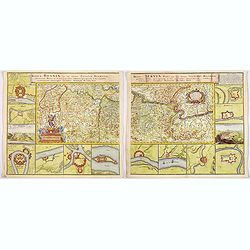
Regnum Bosnia, cum finitimis Croatiae, Dalmatiae. . ./ Regni Serviae pars, una cum finitimis Valechiae and Bulgariae. . .
A lovely pair of maps of Croatia, Dalmatia, and Serbia, Walachia, and part of Bulgaria. The first map 8 small inset maps of Ussitza, Brodt, Wihaz, Zwornek, ratscha, Sabat...
Date: Nuremberg, 1740
Selling price: ????
Please login to see price!
Sold in 2018
![[2 maps] Theatre de la Guerre Dans la Petite Tartarie, La Crimee, la Mer Noire, &c.. [and] Seconde Partie de la Crimée.. (2 maps)](/uploads/cache/21474-250x250.jpg)
[2 maps] Theatre de la Guerre Dans la Petite Tartarie, La Crimee, la Mer Noire, &c.. [and] Seconde Partie de la Crimée.. (2 maps)
Set of 2 copper engraved maps from the observations of Guillaume Delisle focusing on the Black Sea with wonderful detail of the surrounding regions. Includes Constantinop...
Date: Amsterdam c. 1744
Selling price: ????
Please login to see price!
Sold
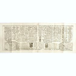
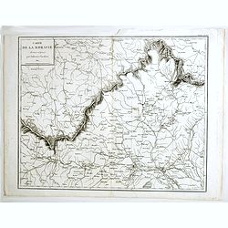
Exactissima Totius DANUBII FLUVII. Tabula et . . .
Two maps on one sheet, showing the course of the River Donau. Originally published by Danckerts. The upper part has a nice originally colored title cartouche and depicts ...
Date: Amsterdam, c. 1744
Selling price: ????
Please login to see price!
Sold in 2009
Théatre de la Guerre en Hongarie, Transilvanie &c
Large, four sheet detailed map of Hungary.
Date: Amsterdam c. 1745
Selling price: ????
Please login to see price!
Sold in 2012
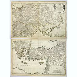
Troisieme partie de la Carte d'Europe conenant ..Russie, Pologne et la Hongrie, la Turquie. . .
A large 2 sheet map, by French cartographer d'Anville, measuring 1030 x 1620 mm when joined together, showing most of Eastern Europe, parts western Russia and parts of th...
Date: Paris, ca. 1760
Selling price: ????
Please login to see price!
Sold in 2017

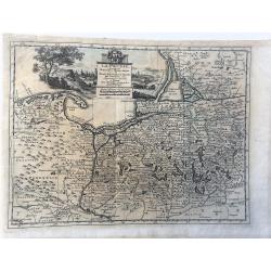
(Dalmatien). Lower left sheet from the famous wall map 'Mappa Geographica novissima Regni Hungariae divisi in suos Comitatus'.
Lower left sheet from the famous wall map "Mappa Geographica novissima Regni Hungariae divisi in suos Comitatus" of Hungary. This part depicting part of Dalmati...
Date: Vienna, 1769
Selling price: ????
Please login to see price!
Sold
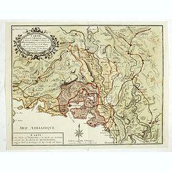
De la Pannonie, De la Liburnie, De la Dalmatie et de la Grece en General.
Fine map of what is now Croatia. By brion de la Tour and Charles Desnos in Paris in 1770. The map has much French text on either side and a very fancy border that was eng...
Date: Paris , 1770
Selling price: ????
Please login to see price!
Sold in 2017
Carte Geographique du Theatre de la Guerre en General representant le Royaume de Hongarie la Principauté de Transylvanie, et les Royaumes de Croacie, de Dalmacie, de Esclavonie, de Bosnie, de Servie . . .
Carte Geographique du Theatre de la Guerre en General representant le Royaume de Hongarie la Principauté de Transylvanie, et les Royaumes de Croacie, de Dalmacie, de Esc...
Date: Augsburg, 1771
Selling price: ????
Please login to see price!
Sold in 2021
Hungary with Part of the Adjoining Principalities &c.
A fine late 18th century copper engraved map of Hungary and Romania published in 'Barlow's General History of Europe'.Thomas Bowen was an English engraver of charts. He w...
Date: London, 1780
Selling price: ????
Please login to see price!
Sold in 2016
Turchia d'Europa divisa Nelle Sue Provincie, e Governi. . .
The pleasing map of the European provinces of the Ottoman Empire, by Antonio Zatta, published during the latter half of the eighteenth century. It shows the administrativ...
Date: Venice, 1782
Selling price: ????
Please login to see price!
Sold in 2021
Le cours du Danube dédié au roy. . .
A later edition of this beautiful and detailed map of the river Danube, originally published by Du Val in 1703. Here with the date "1783" and the address change...
Date: Paris, 1783
Selling price: ????
Please login to see price!
Sold in 2011
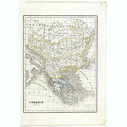
Turquie d' Europe
This finely engraved map is roughly centered on Greece, including the islands of Crete and Cyprus. The map covers the region from Bosnia and Serbia to the Black Sea and C...
Date: Paris, 1783
Selling price: ????
Please login to see price!
Sold in 2016
A map of Hungary, Transilvania, Sclavonia, and Croatia.
Unusual map of Eastern Europe, from Vienna and the Gulf of Venise to the border of Moldova and the Carpathian Mountains. Includes the Balaton lake, Bratislava, Belgrade, ...
Date: London, 1784
Selling price: ????
Please login to see price!
Sold in 2016
Poland, Lithuania and Prussia Drawn from the latest Authorities by Thos. Kitchin Geogr.
Map showing the region along the Baltic Sea from Stettin to Riga. In the lower right is part of the course of the Dnieper river and part of Ukraine.To the right of the ti...
Date: Paris, 1786
Selling price: ????
Please login to see price!
Sold in 2008
L'Ungheria e la Turchia Europea. . .
Cassini's beautiful map of Greece and the Balkans, but also including parts of Germany, today's Ukraine and Italy. It shows the eastern Mediterranean, the Gulf of Venice ...
Date: Rome, 1788
Selling price: ????
Please login to see price!
Sold in 2023
Charte von Ungarn Polen, Russland und der Turkey...
Exceptional folding map of Eastern Europe including the Black Sea published by the Schneider-Weigel firm in Nuremberg, Germany. Includes the countries of Greece, Bulgaria...
Date: Nuremberg, 1789
Selling price: ????
Please login to see price!
Sold in 2010
Carte de la partie d'Albanie occupée par le Bacha de Scutari. . . - Karte des Theils von Albanien so der Bascha von Scutari in besitze hat. . .
Detailed map of Albania. Prepared by François Joseph Maire (Vienna, 1738 - c.1800). F.J. Maire was a publisher, geographer and engineer active in Vienna. He published so...
Date: Vienna, 1788-1789
Selling price: ????
Please login to see price!
Sold in 2014
La Hongrie avec les Provinces adjacentes. . .
Attractive map of Hungary, adorned with a rococo-style title cartouche.Left and right box with geographical information about the area. Printed on 2 paste-on slips.Prepar...
Date: Paris, 1790
Selling price: ????
Please login to see price!
Sold in 2009
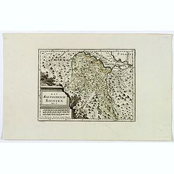
Das Koenigreich Bosnien.
A nice map of Bosnia, mapped with its old borders, prior to the Ottoman rule. Western Bosnia is labelled "Turkish Croatia". The region is seen as very heavily w...
Date: Vienna, 1790
Selling price: ????
Please login to see price!
Sold in 2018
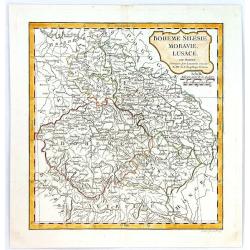
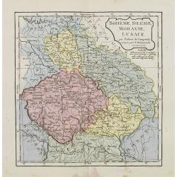
Boheme, Silesie, Moravie, Lucace.
A highly detailed map of Bohemia, Silesia, Moravia and Lusace, by Charles François Delamarche, the successor to Robert de Vaugondy.Charles Francois Delamarche, (1740–1...
Date: Paris, 1794
Selling price: ????
Please login to see price!
Sold in 2016
![[I. Dago] [I. Wormso]](/uploads/cache/22199-250x250.jpg)
[I. Dago] [I. Wormso]
Extremely rare sea chart centered on Hiiumaa (Dago) and Vormsi (Wormso) Islands, off the coast of Estonia.
Date: Amsterdam, 1797
Selling price: ????
Please login to see price!
Sold in 2008
Turkey in Europe.
An attractive map, in beautiful original color, of Turkey in Europe, that part of the Ottoman Empire that lay west of Constantinople. It shows the countries that border t...
Date: London, 1800
Selling price: ????
Please login to see price!
Sold in 2020
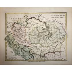
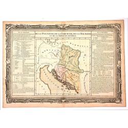
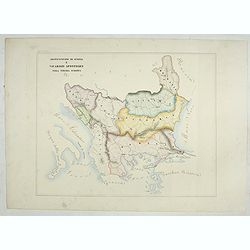
Pannonia, Dacia, Illyricum et Moesia.
A copper engraved map by John Roper, published in "Wilkinson's Atlas Classica" in 1801. The map covers the ancient Roman provinces of Pannonia, Dacia, Illyricum...
Date: London, 1801
Selling price: ????
Please login to see price!
Sold in 2016
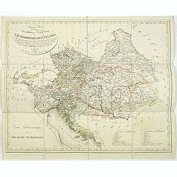
Allgemeine Charte zur Uebersicht der Kirchlichen Verfassung des oesterreichischen Staates = Carte eccle´siastique de la monarchie autrichienne : mit Bemerkung aller Erzbisthu¨mer. . .
Detailled map showing Central Europe and showing the Austria-Hungarian Monarchy. The map includes Austria, with parts of Poland, Germany, Italy, prepared by Karl Joseph K...
Date: Vienna, Kunst und Industrie Comptoirs,1804
Selling price: ????
Please login to see price!
Sold in 2013
Hongrie, Turquie Europe..
Map of Hungary, southeast European countries in the Balkan peninsula, and Greece. By C. F. Delamarche, the successor of Robert de Vaugondy, Geographer.
Date: Paris, 1794 - 1806
Selling price: ????
Please login to see price!
Sold in 2008
Bohême, Silésie, Moravie, Lusace.
Map of central Europe including Bohemia, Austria, Hungary, Silesia and Moravia. By C. F. Delamarche, successor of Robert de Vaugondy, Geographer.
Date: Paris, 1794 - 1806
Selling price: ????
Please login to see price!
Sold in 2015
Carte de la Moravie déssinée et gravée par Ambroise Tardieu.
Very detailed map including Vienna and the Czech Republic with Prague Olmutz.
Date: Paris, 1822
Selling price: ????
Please login to see price!
Sold in 2023
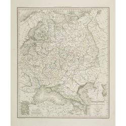
Russie d'Europe . . .
Detailed map of the European part of Russia, including the Black Sea region, prepared by A. H. Basset, rue Saint-Jacques, no. 64, Paris and published in Atlas classique e...
Date: Paris, A.H. Basset, 1828
Selling price: ????
Please login to see price!
Sold in 2009
Lengyel Fold
Small Hungarian map of Poland and Lithuania. Major cities and towns depicted in red, mountains, rivers, woodlands and forests are also highlighted in color.
Date: ca. 1830
Selling price: ????
Please login to see price!
Sold in 2016
Carte de la Campagne de l'Armée D'Italie en 1809
Attractive and unusual steel engraved map illustrates the military activities in Austria, Hungary, and the Istria peninsula in 1809, during the Franco-Italian Napoleon fo...
Date: Paris, c1835
Selling price: ????
Please login to see price!
Sold in 2008
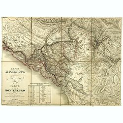
Carte du pays de Montenegro dressée d'après les opérations géodétiques . . .
A rare map of Montenegro, prepared by Mr. le Comte Fedor de Karacsay (1787-1859) and engraved by Pietro Allodi. The title is in Russian, Arabic, and French.In the lower-l...
Date: Vienna, ca. 1838
Selling price: ????
Please login to see price!
Sold in 2018
Turquie d'Europe.
Detailed map of European Turkey, including Greece, Romania, Bulgaria, Bosnie, etc. Prepared by Charles V. Monin (fl.1830-1880) a French cartographer of Caen and Paris. Pu...
Date: Paris, 1845
Selling price: ????
Please login to see price!
Sold in 2019

Djar Mougal de la Milice Lesghine Djar. 29
A very decorative print of a Moghul (also spelled Mughal) from the Lesghine militia after Prince Grigory Grigorievich Gagarin and lithographed by J.Keller. Printed by Lem...
Date: Paris, A.Hauser, ca. 1846
Selling price: ????
Please login to see price!
Sold in 2012

LE CHAMKHAL de TARKY.
A very decorative print of a Chamkhal from Tarky in Dagestan after Prince Grigory Grigorievich Gagarin and lithographed by J.Keller. Printed by Lemercier in Paris. The li...
Date: Paris, A. Hauser, ca. 1846
Selling price: ????
Please login to see price!
Sold in 2015
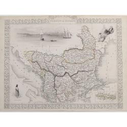
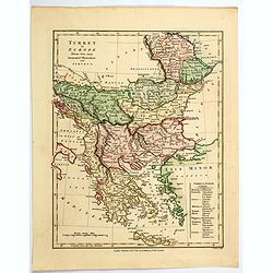
Turkey in Europe.
A very decorative steel-engraved map of South-East Europe, extending from Dalmatia until the Black Sea. Very detailed with place names, rivers, hills, bays, etc. With a s...
Date: London, ca. 1850
Selling price: ????
Please login to see price!
Sold in 2017
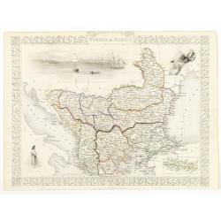
Turkey in Europe.
Decorative steel engraved map of Albania, Macedonia, Romania, Bulgaria, Moldavia and the European part of Turkey with insets of the Bosporus and Constantinople and depict...
Date: London, ca. 1851
Selling price: ????
Please login to see price!
Sold in 2011
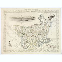
Turkey in Europe.
A decorative steel engraved map of Albania, Macedonia, Rumania, Bulgaria, Moldavia and the European part of Turkey with insets of the Bosporus and Constantinople and depi...
Date: London, ca. 1851
Selling price: ????
Please login to see price!
Sold in 2019
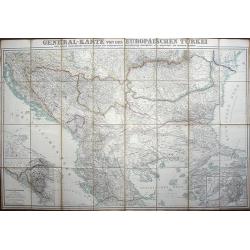
General-karte von der Europäischen Türkei nach allen vorhandenn originalkarten und itinerarischen hülfsmitteln bearbeitet und von Heinrich Kiepert
Map of present-day Greece and Turkey.
Date: Berlin, Dietrich Reimer, 1853
Selling price: ????
Please login to see price!
Sold in 2008
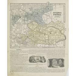
Austria and Prussia.
Map of Austria and Prussia. From Sidney E. Morse''s: System of Geography for the use of schools , published by Harper and brothers, 329 Pearl Street, New York.An 150 year...
Date: New York, 1855
Selling price: ????
Please login to see price!
Sold in 2008
Diocesi e Vacariati Apostolici della Turchia, Grecia, Ed Isole Jonie (Tav XCIII)
A large-format map of Eastern Europe with its different dioceses. The map is finely engraved and beautifully colored and was prepared by Girolamo Petri, a lawyer who serv...
Date: Rome, 1858
Selling price: ????
Please login to see price!
Sold in 2022
Provincia ecclesiastica di Antivari e arciv di durazzo nella Turchia Europae (Tav XCVII) ( Albania)
This large-format map of Albania with it's different dioceses. The map is finely engraved and beautifully colored and was prepared by Girolamo Petri, a lawyer who served ...
Date: Rome, 1858
Selling price: ????
Please login to see price!
Sold in 2025
Arcivescovato di Scopia e vicariati Apostolici nella Turchia Europea. (Tav XCVIII)
This large-format map of Eastern Europe, including Bosnia, Herzegovina, Albania, Montenegro, Servia, Bulgaria, Romania and Molavia. The map is finely engraved and beautif...
Date: Rome, 1858
Selling price: ????
Please login to see price!
Sold in 2025
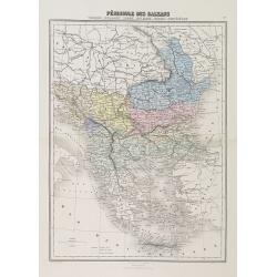
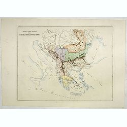
Péninsule des Balkans. Turquie -Roumanie - Serbie -Bulgarie - Bosnie - Monténégro.
A decorative map of the Balkan States (Romania, Serbia, Bulgaria, Bosnia and Montenegro) from Géographie Universelle, Atlas Migeon, published by J. Migeon.From one of th...
Date: Paris, 1874
Selling price: ????
Please login to see price!
Sold in 2010
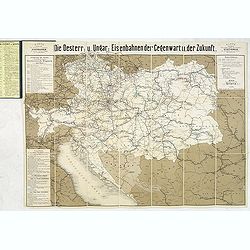
Die Österreichisch & Ungarischen Eisenbahnen der Gegewart und der Zukunst.
Rare rail-way folding map of Austria, Hungary and Galicia (centered on Lviv, or Lemberg ). Published in Vienna, by Artaria & Co. The firm was founded by the cousins C...
Date: Vienna, 1881
Selling price: ????
Please login to see price!
Sold in 2013
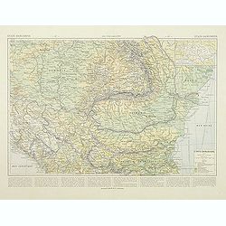
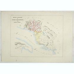
Etats Danubiens. . .
Map of east of Europe, showing Hongriae, Serbia, Bulgaria, Romania, Bosnia and part of the Black Sea up to Odessa. Text in French in lower part.This publication is in fac...
Date: Paris, E.Capiomont,1894
Selling price: ????
Please login to see price!
Sold in 2014
![Mer Adriatique. Environs de Raguse (Dubrovnik). Troisième Feuille. Gravosa-Raguse-Breno.. [278]](/uploads/cache/23474-250x250.jpg)
Mer Adriatique. Environs de Raguse (Dubrovnik). Troisième Feuille. Gravosa-Raguse-Breno.. [278]
Large scale coastal chart showing a stretch of Dalmatian coast centered on Dubrovnik and covering the area from Verbitza as far as Cavtat.With 2 large inset plans illustr...
Date: Paris [1820] 1932
Selling price: ????
Please login to see price!
Sold in 2023
