Browse Listings in Europe
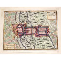
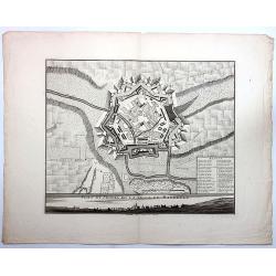
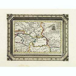
Bouchain: Ville Forte du Comte de Hainaut Situee Sur la Riviere d'Escaut.
Fine little plan of the fortification of Bouchain by Pieter Devel and published by Eugene Henry Fricx. The Siege of Bouchain (August – September 1711), was a siege of ...
Date: Brussels, 1711
Selling price: ????
Please login to see price!
Sold in 2013
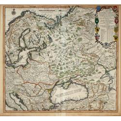
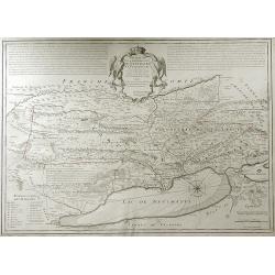
Carte Pour l\'Intelligence des Affaires Presente Des Turcs, des Tartares, des Hongrois, des Polonois, des Suedois, et des Moscovites Aux Environs . . .
Scarce Nicolas de Fer map of the region centred on Russia and extending east to the mouth of the Volga in the Caspian Sea, west to the Baltic, South to the Black Sea, Ita...
Date: Paris, 1711
Selling price: ????
Please login to see price!
Sold in 2014
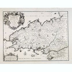
Gouvernement général du Duché de Bretagne, Divisée en Haute et Basse.
First state. Separation in Upper and Lower Brittany as shown on the 1705 plate is now corrected.
Date: Paris, 1711
Selling price: ????
Please login to see price!
Sold in 2015
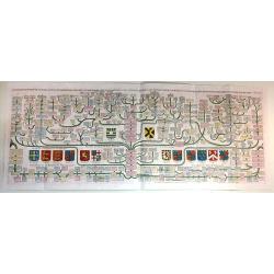
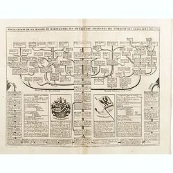
Carte généalogique de la maison de Plantagenette et des ducs Normandie avec les branches, et les alliances quelles, ont formées; pour conduire a l'intelligence de l'histoire d'Angleterre et d'Ecosse et d'Irlande.
A very attractive, hand colored genealogical chart of mediaeval English royal families, including thirteen coats of arms of Edward the Confessor, Edward III, the Plantage...
Date: Paris, 1711
Selling price: ????
Please login to see price!
Sold in 2015
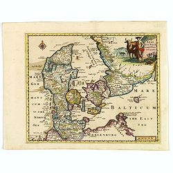
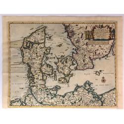
Regni Daniae accuratissima delineatio.
A delightful, attractive small map of Denmark by Philipp Cluver, published in the early years of the eighteenth century. The map has nice, eye catching coloring, enhanced...
Date: London, 1711
Selling price: ????
Please login to see price!
Sold in 2018
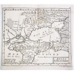
ETATS du Cham des Tartares dependent de la Porte.
A rare copper engraved map of the southern Ukraine and the Crimea peninsula. From 'Theatre complete et particularise de la Guerre du Nort', La Haye ,1711.
Date: La Haye, 1711
Selling price: ????
Please login to see price!
Sold in 2021
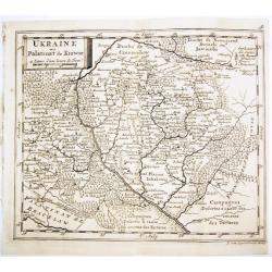
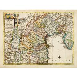
UKRAINE ou Palatinat de Kiowie.
A rare copper engraved map of the central Ukraine and the Kiev surrounding. From 'Theatre complet et particularise de la Guerre du Nort', La Haye ,1711.
Date: La Haye, 1711
Selling price: ????
Please login to see price!
Sold in 2021
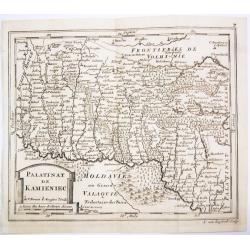
PALATINAT DE KAMIENIEC.
A rare copper engraved map of the former Polish Palatinate of Kamieniec in the south-western Ukraine. From 'Theatre complet et particularise de la Guerre du Nort', La Hay...
Date: La Haye, 1711
Selling price: ????
Please login to see price!
Sold in 2021
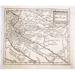
PALATINAT DE BRACLAW.
A rare copper engraved map of the old Polish Palatinate of Braclaw in the south-western Ukraine. From 'Theatre complet et particularise de la Guerre du Nort', La Haye , 1...
Date: La Haye, 1711
Selling price: ????
Please login to see price!
Sold in 2021
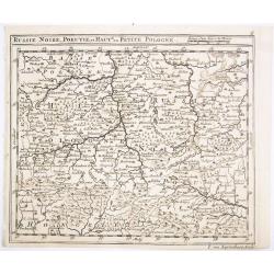
RUSSIE NOIRE, POKUTIE,et HAUTE ou PETITE POLOGNE.
A rare copper engraved map of the western Ukraine and southern Poland. From 'Theatre complet et particularise de la Guerre du Nort', La Haye , 1711.
Date: La Haye, 1711
Selling price: ????
Please login to see price!
Sold in 2021
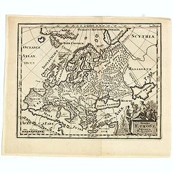
Summa Europae Antique Descriptio.
Striking and decorative map of Europe, with an ornate cartouche. Nice dark impression. From Cluverius' "Introductio in Universam Geographiam" (first issued in 1...
Date: London, 1711
Selling price: ????
Please login to see price!
Sold in 2023
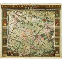
't Hooge Heemraedschap van Delflant.
Beautifully engraved map, a reduced from of the wall map, of 't Hooge Heemraedschap van Delfland prepared by Nicolaas and Jacob Kruikius. Decorated with the Delfland coat...
Date: Delft, 1712
Selling price: ????
Please login to see price!
Sold
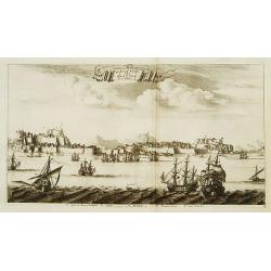
De stadt Korfu, eertytss Korcyra in 't verschiet.
A beautifully engraved and richly detailed panoramic view of the town of Corfu. In lower part a key to five principal spots in the town. From Galerie Agréable du Monde, ...
Date: Leiden 1712
Selling price: ????
Please login to see price!
Sold
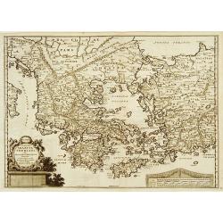
Graecia Sophiani per Abrahamum Ortelium..
A beautifully engraved and richly detailed map of Ancient Greece, after Abraham Ortelius who is given credit in the title. Engraved by J.stemmers.From Galerie Agréable d...
Date: Leiden 1712
Selling price: ????
Please login to see price!
Sold
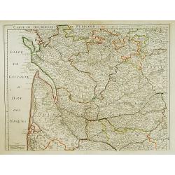
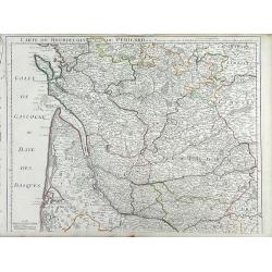
Carte du Bourdelois du Perigord et des Provinces voisines.
Guillaume de l' Isle (1675-1724), Royal Geographer, was the most influential cartographer of the first quarter of the 18th century. 'Atlas de Géographie' (1700-12), post...
Date: Paris, 1712
Selling price: ????
Please login to see price!
Sold
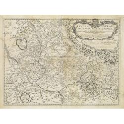
Tavola Generale della Provincia dell' Umbria . . .
An uncommon, map of part of the Umbria region, based on the reports of Giacomo Cantelli da Vignola and published in Roma in Giacomo de Rossi's world atlas "Mercurio ...
Date: Rome, ca. 1712
Selling price: ????
Please login to see price!
Sold in 2009
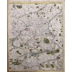
Partie Meridionale de Picardie
Finely detailed map of the Picardy region of northwestern France., including the regional capital of Amiens in the center of the map. A map key is in the bottom left corn...
Date: Paris, 1712
Selling price: ????
Please login to see price!
Sold in 2010
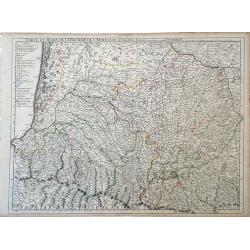
Carte du Bearn de la Bigorre de L'Armagna et des Pays Voisins.
Map of the Pyrenees Mountains regions of France and Spain. Depicts the regions of Aquitaine and Midi-Pyrenees in France and Navarra in Spain. Also, shows abbeys by religi...
Date: Paris, 1712
Selling price: ????
Please login to see price!
Sold in 2010
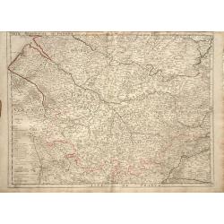
Theatre de la guerre en Flandres.
Unusual large-scale map of the French-Belgium border. Shows the area from Douai and Valenciennes to Ypres/Ieper and Courtrai/Kortrijk. Includes Roubaix, Lille, and Tourna...
Date: Brussels, 1712
Selling price: ????
Please login to see price!
Sold in 2014
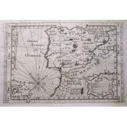
Tabula totius Hispaniae.
Scarce map extending from Madeira and Lanzarote, to the border of France. Published in Montecalerio's "Chorographica descriptio Provinciarum et Conventuum Fratrum mi...
Date: Rome, 1643-1712
Selling price: ????
Please login to see price!
Sold in 2016
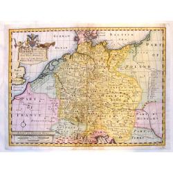
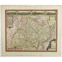
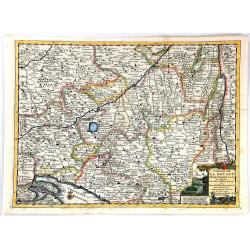
A New Map of Present Germany, Shewing Its Principal divisions, Cities, Towns, Rivrs, Mountains &c.
A fine copper engraved map of "Present Germany". Fancy, large title cartouche with the coat of arms of William, Duke of Gloucester, son of Queen Anne, to whom t...
Date: London, 1712
Selling price: ????
Please login to see price!
Sold in 2015
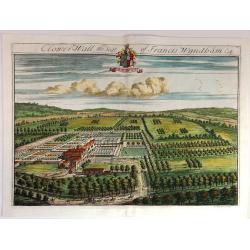
Clower-Wall the Seat of Francis Wyndham, Esq.
A large, fine, copper engraved print illustrating a birds-eye view of Clower-Wall, the Seat of Francis Wyndham, Esq.Published in 1712 for Robert Atkyns. Drawn and engrave...
Date: London, 1712
Selling price: ????
Please login to see price!
Sold in 2019
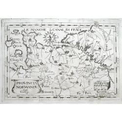
Provincia Normaniae.
Scarce map of Normandy, extending from the Channel Islands to Paris. Published in Montecalerio's "Chorographica descriptio Provinciarum et Conventuum Fratrum minorum...
Date: Rome, 1643-1712
Selling price: ????
Please login to see price!
Sold in 2016
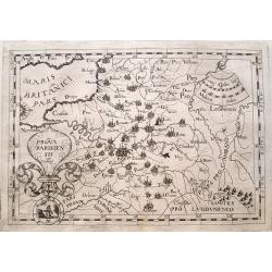
Prova Parisiensis...
Scarce map centred on Paris and extending from Calais to Auxerre, and east until Metz. Published in Montecalerio's "Chorographica descriptio Provinciarum et Conventu...
Date: Rome, 1643-1712
Selling price: ????
Please login to see price!
Sold in 2016
Plan et Profil de la Ville de Maubeuge.
A detailed plan of the town and profile of Maubeuge. Maubeuge is a commune in the Nord department in northern France. It is situated on both banks of the Sambre River, e...
Date: Amsterdam, 1712
Selling price: ????
Please login to see price!
Sold in 2019
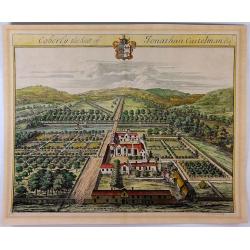
Coberly the Seat of Jonathan Castelman Esq.
A fine, large, detailed birds-eye view of Coberly by Kip, who produced the engravings for the remarkable "The Ancient & Present State of Gloucestershire", p...
Date: London, 1712
Selling price: ????
Please login to see price!
Sold in 2023
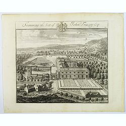
Stanway, the Seat of John Tracey Esq / Didmartin, the Seat of Robert Codrington Esq.
An attractive, and striking pair of early eighteenth century copperplate engravings of staely English homes, from Sir Robert Atkyn's The Ancient and Present State of Glou...
Date: London, ca 1712
Selling price: ????
Please login to see price!
Sold in 2018
L'Etat de L'Eglise..
Although not renowned for the originality of his work, Pieter van der Aa is highly thought of for the design and quality of his output. Showing central part of Italy. Its...
Date: Amsterdam 1713
Selling price: ????
Please login to see price!
Sold
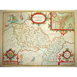
Denbighshire.
Highly decorative map of the county of Denbighshire, located in the northwest corner of Wales. The upper right corner inset contains a plan of the town of Denbigh, along ...
Date: London 1713
Selling price: ????
Please login to see price!
Sold
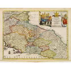
L'Etat de L'Eglise..
Although not renowned for the originality of his work, Pieter van der Aa is highly thought of for the design and quality of his output. Showing central part of Italy. Its...
Date: Amsterdam 1713
Selling price: ????
Please login to see price!
Sold
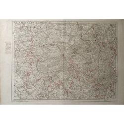
Partie Meridionale de Champagne.
A very detailed map of the Champagne region in France by Guillaume De L'Isle. Major cities such as Provins and Chatillon are included as well as major rivers, lakes and f...
Date: Paris, 1713
Selling price: ????
Please login to see price!
Sold in 2010
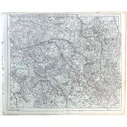
Parte Meridionale de Champagne.
Map of northeastern France centered on the southern Champagne region. The map includes other surrounding regions including Brie, Burgundy, Lorraine and Berry, and numerou...
Date: Paris, 1713
Selling price: ????
Please login to see price!
Sold in 2010
Carte de la Souverainete de Neuchatel et Vallangin.
Map of the Neuchatel region of Switzerland, showing the town of Neuchatel as well as Lake Neuchatel. This finely detailed map shows the shows abbeys and priories, castles...
Date: Paris, 1713
Selling price: ????
Please login to see price!
Sold in 2010
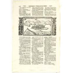
Chersonesus.
Town view of Sevastopol, set in a text page with Latin text. Taken from "Universus Terrarum Orbis", printed in Padua in 1713.
Date: Padua, Lasor a Varea, 1713
Selling price: ????
Please login to see price!
Sold in 2011
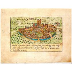
Lunden.
A quaint little city view of the town Lunden in Germany. Engraved for Francesco Valegio's townbook: "Raccolta di le piv illustri et farmose citta di tutto il mondo.&...
Date: Venice, 1600 or 1713
Selling price: ????
Please login to see price!
Sold in 2014
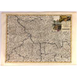
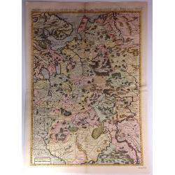
Cercle de la Haute Saxe...
This quaint map shows the Upper Saxon Circle according to the latest map of Pierre Van der Aa. The area encompasses parts of Saxony, Thuringia and Saxony-Anhalt. Central ...
Date: Leiden, 1713
Selling price: ????
Please login to see price!
Sold in 2018
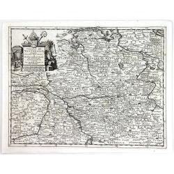
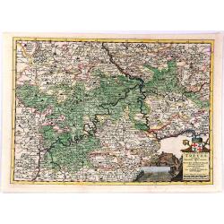
Cercle Electoral du Rhin...
"Cercle Electoral du Rhin. Suivant les Nouvelles Observations de Mess.rs de l'Academie Royale des Sciences, etc. Augmentees de Nouveau. / Cercle du Haut Rhin. Suivan...
Date: Leiden, 1713
Selling price: ????
Please login to see price!
Sold in 2020
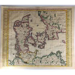
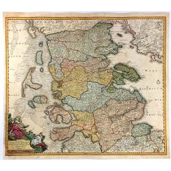
Le Royaume de Danemark Avec Une Partie de la Suede.
A detailed map of Denmark and southwestern Sweden, published by Van der Aa in his “Le Nouveau Theatre du Monde . . . .” This bold map of Denmark and southern Sweden s...
Date: Leiden, 1713
Selling price: ????
Please login to see price!
Sold in 2018
Cercle de Westphalie.
A detailed map by Pierre van der Aa of the German province of Westphalie, following the new observations of the “Academie Royale des Sciences”. It has a beautiful car...
Date: Leiden, 1713
Selling price: ????
Please login to see price!
Sold in 2016
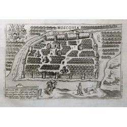
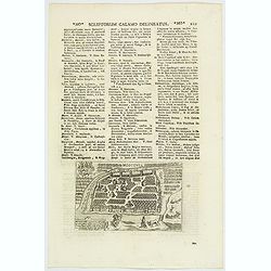
Moscovia.
An early plan of Moscow set on a page with latin text. Small but detailed view with many buildings, the city fortifications, and figures including a mounted archer. On th...
Date: Padua, 1713
Selling price: ????
Please login to see price!
Sold in 2016
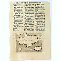
Piccola Tartaria.
A basic map of the Crimea, with little detail shown. Small strap-work cartouche, set in a text page with Latin text. Taken from "Universus Terrarum Orbis", prin...
Date: Padua, Lasor a Varea, 1713
Selling price: ????
Please login to see price!
Sold in 2016
Moraviae Nova et post omnes priores accuratissima delineatio.
The cartographer of this map was Johan Amos Comenius (1592-1670), Czech cartographer and priest. In the upper part four views of Polna, Olmuts, Brin and Znaim.The sixth s...
Date: Amsterdam, between 1680 and 1713
Selling price: ????
Please login to see price!
Sold in 2021
Moscovia / Moscovia Imperium.
An early plan of Moscow, set in text, first published ca.1600, with the buildings wonderfully shown in perspective. Based on the Braun & Hogenberg map, it is decorate...
Date: Padua, 1713
Selling price: ????
Please login to see price!
Sold in 2020
Le Duche de Lunebourg. . .
A lovely, detailed map by Pierre Van der AA of the northern German region of Luneburg in Lower Saxony, roughly situated between the Elber and the Aller Rivers. Luneburg i...
Date: Leiden, 1713
Selling price: ????
Please login to see price!
Sold in 2021
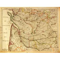
Carte du Bourdelois du Perigord et des provinces voisines..
Map covering the area from La Rochelle till the surrounding country of Bordeaux to the south and till Limoges and Cahors to the east.
Date: Paris 1714
Selling price: ????
Please login to see price!
Sold
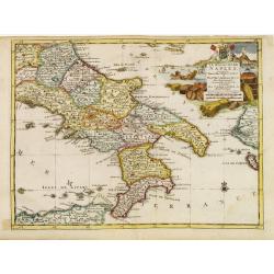
Le Royaume de Naples..
Uncommon and detailed map of southern Italy, from Nouvelle atlas, trés-exact et fort commode pour toutes sortes de personnes, contenant les principales cartes géographi...
Date: Leiden 1714
Selling price: ????
Please login to see price!
Sold
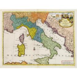
L'Italie.
Uncommon and detailed map of Italy, from Nouvelle atlas, trés-exact et fort commode pour toutes sortes de personnes, contenant les principales cartes géographiques.. .A...
Date: Leiden 1714
Selling price: ????
Please login to see price!
Sold
Seigneurie de Venise..
Uncommon and detailed map of the Gulf of Venice and its mainland, from Nouvelle atlas, trés-exact et fort commode pour toutes sortes de personnes, contenant les principa...
Date: Leiden 1714
Selling price: ????
Please login to see price!
Sold
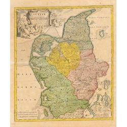
Tabula Generalis Jutiae.
Johan Baptist Homann (1663-1724). Outstanding German cartographer. Founder of the Homann publishing house. After the death of the son Johann Christoph, the firm continued...
Date: Nurnberg, 1714
Selling price: ????
Please login to see price!
Sold
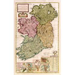
A new map of Ireland devided into its provinces..
A good copy of this very decorative and detailed large scale map. 12 inset plans of the towns of Dublin, Cork, Kinsale, Limerick, Waterford and Galway, and of the Giants'...
Date: London 1714
Selling price: ????
Please login to see price!
Sold

Provincia Di Terra d'Otranto . . .
In lower left hand corner a large ornamental title cartouche. A decorative map of the Otranto region in Italy, based on the reports of Giacomo Cantelli da Vignola and pub...
Date: Rome, ca. 1714
Selling price: ????
Please login to see price!
Sold
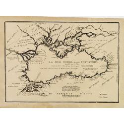
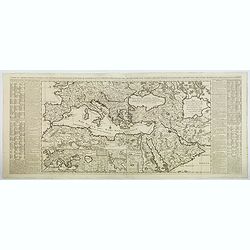
(LA MER NOIRE, Autrefois PONT-EUXIN, . . .)
Maps of the region Black sea, showing the cities of Constantinople, Heraclee, Kafa. From his 'Atlas Curieux'.Accomplanied by an engraved text sheet "Description de l...
Date: Paris, 1714
Selling price: ????
Please login to see price!
Sold in 2010
Carte du Bourdelois du Perigord et des Provinces voisines. . .
Finely detailed map of the Bordeaux region of France by Guillaume de L'Isle. Shows the French coast at the Bay of Biscay, the Garonne River and the port city of Bordeaux....
Date: Paris, 1714
Selling price: ????
Please login to see price!
Sold in 2010
Zee en Landtogt door A. Jenkinson van Astracan Gedaan na Tartarien en terug tot in Moscow
A map of the lands around the Black Sea and the Caspian Sea, illustrating the travels of A. Jenkinson. Decorated with a nice title-cartouche.Although not renowned for the...
Date: Leiden, 1714
Selling price: ????
Please login to see price!
Sold in 2011
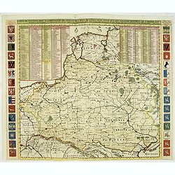
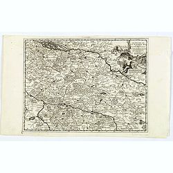
Carte De Pologne Avec La Chronologie Des Rois Et Des Ducs De Lithuanie, Ainsi Que Des Grands Maitres De L'Ordre Teutonique Les Evechez et Archeveches, et Les Armes Des Provinces . . .
Map of Poland with a key table to the towns, and 30 coats of arms on both sides, extending south the Black Sea. Zacharias Chatelain (d.1723) was the father of Henri Abrah...
Date: Amsterdam, ca. 1714
Selling price: ????
Please login to see price!
Sold in 2012
![[No title] La mer noire, autrefois Pont-Euxin. . .](/uploads/cache/32268-250x250.jpg)
[No title] La mer noire, autrefois Pont-Euxin. . .
Map of the Black sea, with the border countries of Turkey (in Asia), Romania, Bulgaria, Moldova, Ukraine and Russia with rivers and coastal towns shown. (Constantinople, ...
Date: Paris, 1714
Selling price: ????
Please login to see price!
Sold in 2020
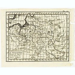
La Pologne suivant les degrés de l'academie des sciences de Paris 1714.
Uncommon miniature map of Poland from one of the editions of the work by Claude Buffier (25 May 1661 – 1737), was a French philosopher, historian & educationalist, ...
Date: Paris, ca. 1714
Selling price: ????
Please login to see price!
Sold in 2012
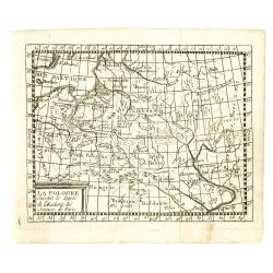
La Pologne suivant les degrés de l'academie des sciences de Paris.
Uncommon miniature map of Poland from one of the editions of the work by Claude Buffier (25 May 1661 – 1737), was a French philosopher, historian & educationalist, ...
Date: Paris, ca. 1714
Selling price: ????
Please login to see price!
Sold in 2015
Mingrelie autrefois Colchis, Pays baigné au Couchant par la MER NOIRE. . .
Uncommon and detailed map of the kingdom of Colchis, in the region of Mingrelia, north west Georgia, from Nouvelle atlas, très-exact et fort commode pour toutes sortes d...
Date: Leiden, 1714
Selling price: ????
Please login to see price!
Sold in 2014
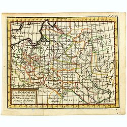
La Pologne suivant les degrés de l'academie des sciences de Paris.
Uncommon miniature map of Poland from one of the editions of the work by Claude Buffier (25 May 1661 – 1737), who was a French philosopher, historian and educationalist...
Date: Paris, ca. 1714
Selling price: ????
Please login to see price!
Sold in 2016
Genealogie de la maison de Wittemberg, ses diferentes branches, ses titres et ses aliances.
Representation of the royal- ducal genealogical tree of the House Wirtemberg with titles, coat of arms and relevants, from volume II of the monumental "Atlas Histori...
Date: Amsterdam, 1714
Selling price: ????
Please login to see price!
Sold in 2014
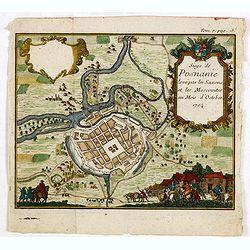
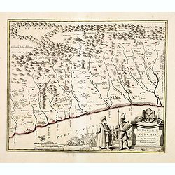
(Poznan) Siege de Posnanie levé par les Saxons & les Moscovites au Mois d'Octobre 1704
Uncommon print of the Battle of Poznan which battle took place on August 9, 1704 in Poznan, Poland during the Great Northern War. The Swedes won the battle.
Date: ca. 1714
Selling price: ????
Please login to see price!
Sold in 2015
A New Map of Denmark, Norway, Sweden & Moscovy.
A striking decorative map of Skandinavia with Russian Europe added. The cities in Germany and Poland are shown as being part of Sweden and Denmark. Nova Zembla is shown a...
Date: London, 1714
Selling price: ????
Please login to see price!
Sold in 2015
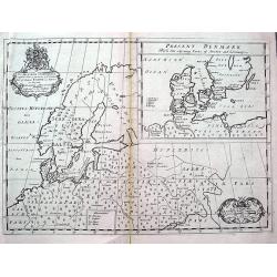
Nouvelle Carte Geographique du Royaume de Dannemarck avec une Table des Villes les Plus Remarquables.
An impressive engraving from Chatelain’s celebrated encyclopedia, “Atlas Historique”. This is a lovely impression of Chatelain’s large map of Denmark. The map cov...
Date: Amsterdam, 1714
Selling price: ????
Please login to see price!
Sold in 2017
Nouvelle Carte Des Etats Du Grand Duc De Moscovie En Europe.
A detailed map of the Northern and Southern parts of Russia in Europe. A nicely detailed copperplate engraving covering the region from Vibourg in the west, Astracan in t...
Date: Amsterdam, 1714
Selling price: ????
Please login to see price!
Sold in 2018
L'Archeveche de Treves ....
A fine small map of the Archdiocese of Trier in Germany. From Pieter van der Aa’s, “Atlas Nouveau et Des Curieux” published in Leiden in 1714. The cartouche has a c...
Date: Leiden, 1714
Selling price: ????
Please login to see price!
Sold in 2017
Cercle de la Souabe Meridionale ....
A fine small map of the Circle of the Souave. From Pieter van der Aa’s, “Atlas Nouveau Et Des Curieux”, published in Leiden in 1714. This informative map shows the ...
Date: Leiden, 1714
Selling price: ????
Please login to see price!
Sold in 2018
Ducatus Slesvicensis ...
This large, striking, copper engraved map of the Schleswig-Holstein region of Germany names the fortified cities of Flensborg, Tonning, Husum, Sonderborg, and Sleswight. ...
Date: Nuremberg, 1714
Selling price: ????
Please login to see price!
Sold in 2017
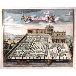
Giardino dell N.H. Sig.r Gio. Francesco Morosini in Padova.
A fine large copper engraving of the garden of N.H. Signor Francesco Morosini in Padua. Published in 1714 in Nuremberg, it is by Volckamer from "Nurnbergische Hespe...
Date: Nuremberg, 1714
Selling price: ????
Please login to see price!
Sold in 2016
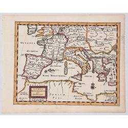
LUMEN HISTORIARUM per OCCIDENTEM.
A copperplate hand colored map showing the west Mediterranean.
Date: Amsterdam, ca. 1714
Selling price: ????
Please login to see price!
Sold in 2019
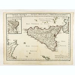
Siciliae Antiquae quae et Sicania et Trinacria dicta tabula geographica.
Map of the ancient Sicily published by Delsile with the imprint 'sur le Quai de l’Horloge cum Privilegio Apr. 1714". Shows forests, a smoking Mount Etna, etc. Cove...
Date: Paris, 1714
Selling price: ????
Please login to see price!
Sold in 2022
Carte de L'Empire Othoman Consideree dans les Etats de Cette Puissance. . .
This lovely, large map shows the extent of the Ottoman Empire, complete with comparisons to the earlier Empires of Alexander the Great and the Romans. It covers the Medit...
Date: Amsterdam, 1714
Selling price: ????
Please login to see price!
Sold in 2020
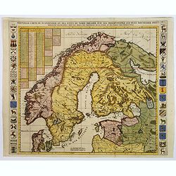
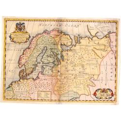
Nouvelle Carte de Scandinavie ou des Etats du Nord dressee sur les Observations. . .
Henri Chatelain's large format decorative map of Scandinavia featuring no less than 34 provincial heraldic shields, 17 on each flank of the map, together with tables of t...
Date: Amsterdam, ca 1714
Selling price: ????
Please login to see price!
Sold in 2018
A New Map of Ancient Scandinavia. . .
A scarce map extending from northern Germany until Russia with old place names. Including Scandinavia and the Baltic. An inset map shows Denmark and southern Sweden in mo...
Date: Oxford, ca 1701-1714
Selling price: ????
Please login to see price!
Sold in 2018
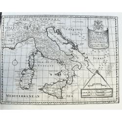
A New Map of Present Italy, together with the Adjoining Islands of Sicily, Sardinia, and Corsica. . .
A scarce copper engraved map of Italy with many places names. A legend key identifies universities. With a large title banner and a distance scale with dividers, dedicate...
Date: Oxford, ca 1701-1714
Selling price: ????
Please login to see price!
Sold in 2020
Carte Particuliere des environs de Roermonde, Venlo, le Mararais de Peel, &c.
Detailed map of the area of Roermond, Venlo, Eindhoven. Prepared by E.H.Frix.
Date: Amsterdam 1715
Selling price: ????
Please login to see price!
Sold
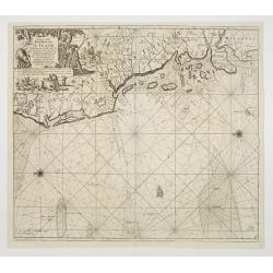
Paskaart vande West Kust van Jutland Van Busem tot aen 't Jutlandsche Riff.
A fine chart of the west coast of Schleswig-Holstein with the North Frisian Islands, Pelworm to Sylt and the west coast of Jutland. With a very large title-cartouche.From...
Date: Amsterdam 1715
Selling price: ????
Please login to see price!
Sold

COLLEGII REGALIS APUD CANTABRIGIENSES SACELLUM / KINGS COLLEGE CHAPPEL IN CAMBRIDGE
A large, superb profile of the famous Kings College Chapel of Cambridge University, as seen in the very early years of the 18th century. The title of the view is shown in...
Date: London, c. 1715
Selling price: ????
Please login to see price!
Sold
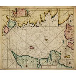
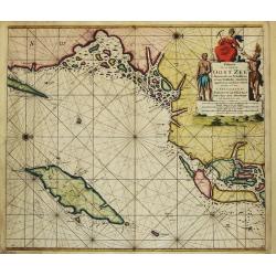
Paskaart van t' Schager-Rak Soo 't by de Oost-vaerende Zee Luyden gemeenlyk bezylt wordt.
The successful van Keulen firm published charts, pilot guides and sea-atlases for over 2 centuries. Founded by Johannes van Keulen, his son Gerard led the firm to its zen...
Date: Amsterdam, 1715
Selling price: ????
Please login to see price!
Sold
Paskaart Voor een gedeelte van de Oost-Zee. Beginnende van Schenkkenes tot aan Stokholm.
The successful van Keulen firm published charts, pilot guides and sea-atlases for over 2 centuries. Founded by Johannes van Keulen, his son Gerard led the firm to its zen...
Date: Amsterdam, 1715
Selling price: ????
Please login to see price!
Sold