Browse Listings in Europe
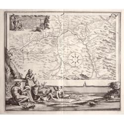
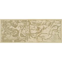
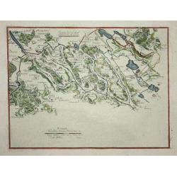
REGION IS INTER TIBUR, CARSEOLOS. ET. SUBLACUM DESCRIPTIO DISSERTATIONI. DE AQUIS ET. AQUAAEDUCTIBUS VETERIS ROMAE PRAEMISSA authore Raph Fabretto Gasp f, Urbinate\'.by Jan van Vianen
Rare copper engraving from Tibur (Tivoli) and the water supply for Rome with two beautifully ornate cartouche.Engraved by Jan van Vianen after Jan Goeree published by Fra...
Date: Amsterdam, 1704
Selling price: ????
Please login to see price!
Sold in 2013
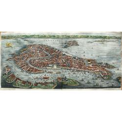
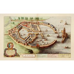
Venetia.
First state of this very large bird's-eye town view of Venice which can be considered the most beautiful and accurate of the XVII century.Engraved in 1670 by Julius Milhe...
Date: Amsterdam, 1704
Selling price: ????
Please login to see price!
Sold in 2020
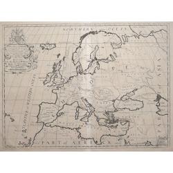
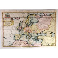
A New Map of Europe, According to the Present General Divisions, and Names of its Countries together with their Capital Cities Chief Rivers Mountains &c.
Drawn by Edward Wells engraved by M. Burg. An attractive and decorative early map of Europe from the beginning of the 18th Century. This map was part of an atlas dedicat...
Date: London, 1704
Selling price: ????
Please login to see price!
Sold in 2016
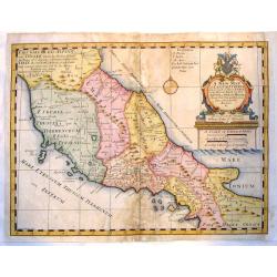
A New Map of Latium, Etruria and as Much of Ancient Italy as Lay Between Gallia Cis-Alpina and Graecia Magna.
A fine copper engraved map of ancient Italy. Lovely, large title cartouche with the coat of arms of William, Duke of Gloucester, son of Queen Anne, to whom the map was de...
Date: London, 1704
Selling price: ????
Please login to see price!
Sold in 2015
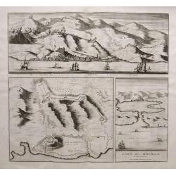
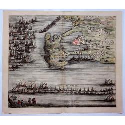
Veue de Sebenico... /Plan de Sebenico.../Port de Sebenico...
Rare large sheet with three maps/views of Šibenik in Croatia. The large panorama view shows the harbour with several sailing ships, the detailed city in the background, ...
Date: Amsterdam, 1704
Selling price: ????
Please login to see price!
Sold in 2015
A New Map of Europe, According to the Present General Divisions, and Names of its Countries together with their Capital Cities Chief Rivers Mountains &c..
Drawn by Edward Wells engraved by M. Burg. An attractive and decorative early map of Europe from the beginning of the 18th Century. This map was part of an atlas dedicate...
Date: London, 1704
Selling price: ????
Please login to see price!
Sold in 2015
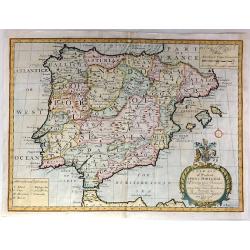
A New Map of Present Spain & Portugal, Shewing Their Principal Divisions, Chief Cities, Townes, Ports, Rivers, Mountains & c. Dedicated to his Highness, William, Duke of Gloucester
Drawn by Edward Wells and engraved by R. Spofforth. An attractive and decorative early map of Spain & Portugal from the beginning of the 18th Century.This map was pa...
Date: London, 1704
Selling price: ????
Please login to see price!
Sold in 2015
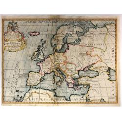
A New Map of Europe According to its Ancient General Divisions and Names of its Countries together with Their Chief Cities, Rivers, Mountains & c. Dedicated to his Highness, William, Duke of Gloucester
Drawn by Edward Wells and engraved by M. Burg. An attractive and decorative early map of Europe from the beginning of the 18th Century.This map was part of an atlas dedic...
Date: London, 1704
Selling price: ????
Please login to see price!
Sold in 2015
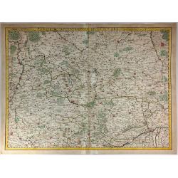
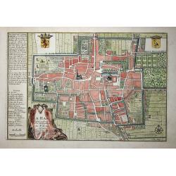
Partie Septentrionale de la Souabe.
Map of Swabia, Germany, one of the ten circles of the Holy Roman Empire. It covers the northern portion of the Empire from Nuremberg south to Wertingen and from Stuttgart...
Date: Paris, 1704
Selling price: ????
Please login to see price!
Sold in 2018
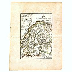
Suède, Norvège et Dannemarck.
An interesting small map of Scandinavia by Nicolas de Fer. From his rare "Petit et Nouveau Atlas". The first edition was published in 1697 and was republished i...
Date: Paris, 1704
Selling price: ????
Please login to see price!
Sold in 2017
Orbetelli, Ville du Sienois en Toscane Assiegee par les Francois en 1646. Ils Furent Contraints de Lever le Siege.
A view of Orbetello, under siege by the French by Pierre Mortier. Orbetello is a town and commune in the province of Grosseto (Tuscany), Italy. A stunning birds-eye persp...
Date: Amsterdam, 1704
Selling price: ????
Please login to see price!
Sold in 2021
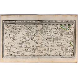
Ath in Hennegau Mitt Angeraenzenden Orthen.
An interesting map of the district of Ath, one of seven administrative districts within the Belgian province of Hainaut (southwest part). It was produced by Gabriel Boden...
Date: Augsburg, 1704
Selling price: ????
Please login to see price!
Sold in 2018
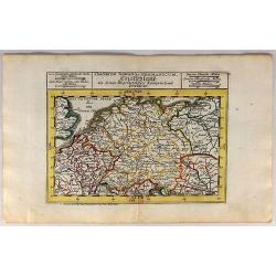
S. Imperium Romano Germanicum Deutschland.
A fine engraved map by Bodenehr, published in Augsburg in 1704. This is a 313 year old antique map of Germany in the days of Imperial Rome, when it comprised numerous lit...
Date: Augsburg, 1704
Selling price: ????
Please login to see price!
Sold in 2018
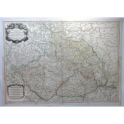
Estats de la Couronne de Boheme. . .
A large decorative map of Bohemia, with Silesia, Lusatia and Moravia. (currently the Czech Republic) centered on Prague, with an elaborate title cartouche featuring two h...
Date: Paris, 1704
Selling price: ????
Please login to see price!
Sold in 2018
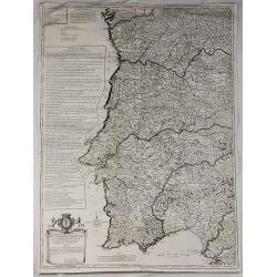
Royaume de Portugal et Partie D'Espagne Dresse sur des Memoires Envoyez de Lisbonne et de Madrid.
Very large map of Portugal (and part of Spain) by Besson, Geographer to the King of France. It was published in Paris in 1704. The map features a decorative title carto...
Date: Paris , 1704
Selling price: ????
Please login to see price!
Sold in 2018
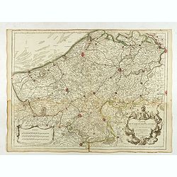
Carte du Comté de Flandre. . .
Map of Flanders, with the address : Chez l’Auteur sur le Quai de l’Horloge (address erased after Horloge). Avec privilege pour vingt ans, 1704." Guillaume de l'I...
Date: Paris, 1704
Selling price: ????
Please login to see price!
Sold in 2022
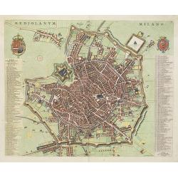
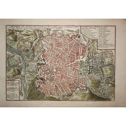
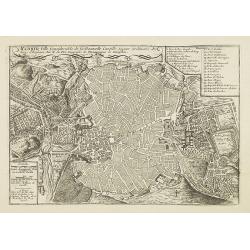
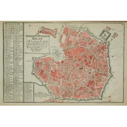
Mediolanum. Milano.
A beautifully engraved and richly decorated plan of Milan. With a key (1-256) in left and right referring to the principal places of interest in the town.Joan Blaeu publi...
Date: Amsterdam, 1704 / 1705
Selling price: ????
Please login to see price!
Sold in 2022
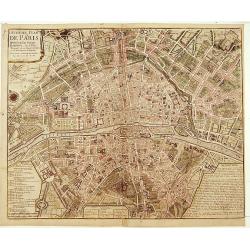
Huitième Plan DE PARIS Divisé en ses Vingts Quartiers.
Beautifull plan of Paris showing the new districts built under the reign of Louis XIV. Description and legends in the margins.
Date: Paris 1705
Selling price: ????
Please login to see price!
Sold
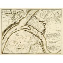
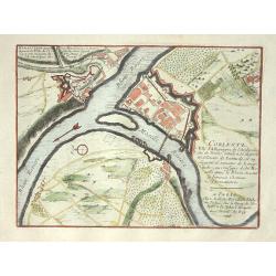
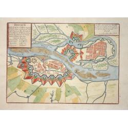
Lot of 2 maps.
2 city plans : Coblentz, ville d'Allemagne.. / Brisach ville forte sur le Rheim?
Date: Paris c.1705
Selling price: ????
Please login to see price!
Sold
Les environs de NAMUR, de Huy et de Charle-roy..
Detailed map of the region of Namen, by Nicolas De Fer, who was a royal French geographer.
Date: Paris 1705
Selling price: ????
Please login to see price!
Sold
Les environs de DINANT, de Philippeville et de Charlemont..
Detailed map of the region of Dinant, by Nicolas De Fer, who was a royal French geographer.
Date: Paris 1705
Selling price: ????
Please login to see price!
Sold
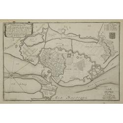
Utriusque Portus Ostiae Delineatio.
A most attractive and fascinating bird's eye plan of this small port near the mouth of the Tiber. Dedicated to Cornelis Witsen, senator of Amsterdam and traveller. Joan B...
Date: Amsterdam, 1705
Selling price: ????
Please login to see price!
Sold in 2013
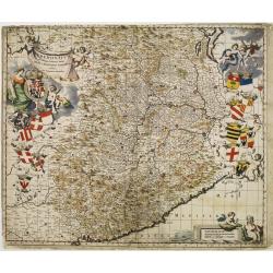
Pedemontium et reliquae ditiones Italiae regiae celsitudini Sabaudicae ..
Map of Piemonte in northern Italy with Turin in the centre. Heraldic title cartouche, numerous coats of arms with cherubs down both sides and figurative scale of miles. T...
Date: Amsterdam 1705
Selling price: ????
Please login to see price!
Sold
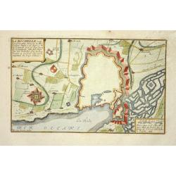
La Rochelle
Nice city plan of La Rochelle with the fortification walls and the port at the ocean.
Date: Paris 1705
Selling price: ????
Please login to see price!
Sold
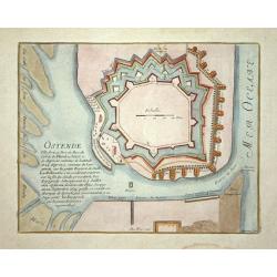
Ostende
Nice city plan of Oostende with the fortification walls and the port.
Date: Paris 1705
Selling price: ????
Please login to see price!
Sold
Strasbourg
Nice city plan of Strasburg with the fortification walls at the river Rhine.
Date: Paris 1705
Selling price: ????
Please login to see price!
Sold
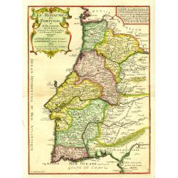
Les Royaumes de Portugal et d'Algarve..
Uncommon map of Portugal, engraved by P.Strackman.
Date: Paris, 1705
Selling price: ????
Please login to see price!
Sold in 2015
Le comte de Namur, partie de L'Evesche de Liege, du Luxembourg ..
Detailed map centered on Naman, and including part of Luxemburg.
Date: Paris, 1705
Selling price: ????
Please login to see price!
Sold
Ausbourg.
Nice city plan of Augsburg.
Date: Paris 1705
Selling price: ????
Please login to see price!
Sold
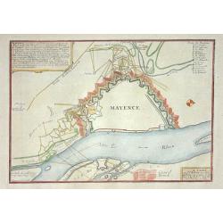
Mayence
Nice city plan of Mainz at the Rhine river.
Date: Paris 1705
Selling price: ????
Please login to see price!
Sold
Donquerque
Nice city plan of Donquerque.
Date: Paris 1705
Selling price: ????
Please login to see price!
Sold
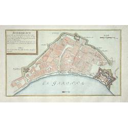
Bordeaux
Nice city plan of Bordeaux.
Date: Paris 1705
Selling price: ????
Please login to see price!
Sold
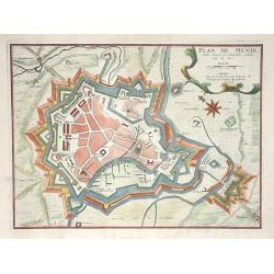
Plan de Menin
Nice city plan of Menin.
Date: Paris 1705
Selling price: ????
Please login to see price!
Sold
Gravelines
Nice city plan of Gravelines.
Date: Paris 1705
Selling price: ????
Please login to see price!
Sold
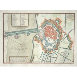
Coblentz
Nice city plan of Coblenz at the Rhine and Moesel river.
Date: Paris 1705
Selling price: ????
Please login to see price!
Sold
Bethune
Nice city plan of Bethune.
Date: Paris 1705
Selling price: ????
Please login to see price!
Sold
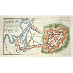
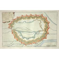
Mont Midi.
Nice plan of Mont Midi in Luxemburg.
Date: Paris 1705
Selling price: ????
Please login to see price!
Sold
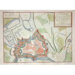
Oudenarde
Nice city plan of Oudenaarde.
Date: Paris 1705
Selling price: ????
Please login to see price!
Sold
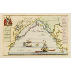
Les Environs de Venise.
Showing in great detail the port of Venice. Includes also a numbered key legend on the right side.Joan Blaeu published during his life three town-books of Italy: Citta de...
Date: Amsterdam, 1705
Selling price: ????
Please login to see price!
Sold in 2009
Carls-Bourg
Nice city plan of CarlsBerg near Bremen with the fortification walls at the Weser river.
Date: Paris 1705
Selling price: ????
Please login to see price!
Sold
Stetin.
Nice city plan of Stetin with the fortification walls at the Oder river.
Date: Paris, 1705
Selling price: ????
Please login to see price!
Sold
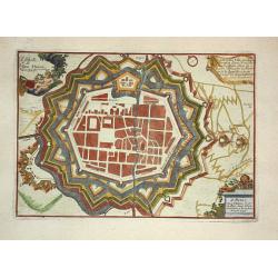
Fribourg.
Nice city plan of freiburg with the fortification walls.
Date: Paris 1705
Selling price: ????
Please login to see price!
Sold
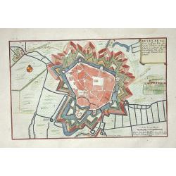
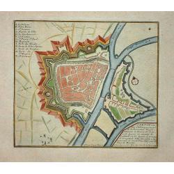
Brisach.
Nice city plan of Brisach with the fortification walls around the city at the Rhine river.
Date: Paris 1705
Selling price: ????
Please login to see price!
Sold
Landau.
Nice city plan of Landau near Karlsruhe with the fortification walls.
Date: Paris 1705
Selling price: ????
Please login to see price!
Sold

Bayonne.
Nice city plan of Bayonne with the fortification walls around the city.
Date: Paris 1705
Selling price: ????
Please login to see price!
Sold
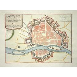
Maestricht.
Nice city plan of Maastricht in the Southern part of The Netherlands.
Date: Paris 1705
Selling price: ????
Please login to see price!
Sold
Siracuse
Nice city plan of Siracuse with the fortification walls.
Date: Paris 1705
Selling price: ????
Please login to see price!
Sold
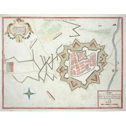
Carmagnole
Nice city plan of Carmagnole with the fortification walls.
Date: Paris 1705
Selling price: ????
Please login to see price!
Sold
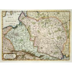
De Staten van de Kroon Poolen.
Detailed map covering the region of present-day Poland, Lithuania, Belarus and Ukraine. Engraved by Anthony d'Winter.
Date: Amsterdam 1705
Selling price: ????
Please login to see price!
Sold
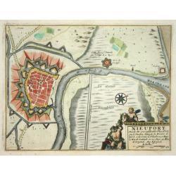
Nieuport
Nice city plan of Nieuport with the fortification walls and the river to the sea.
Date: Paris 1705
Selling price: ????
Please login to see price!
Sold
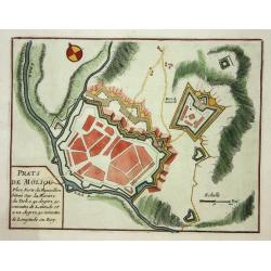
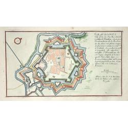
Prats de Moliou.
Nice fortification plan of Prats de Moliou.
Date: Paris 1705
Selling price: ????
Please login to see price!
Sold
Arras.
Nice fortification plan of Arras.
Date: Paris 1705
Selling price: ????
Please login to see price!
Sold
Phalsbourg.
Nice fortification plan of Phalsbourg.
Date: Paris 1705
Selling price: ????
Please login to see price!
Sold
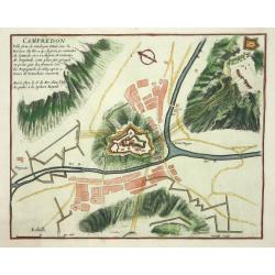
Campredon.
Nice fortification plan of Campredon In the south of France, near the Tarn river.
Date: Paris 1705
Selling price: ????
Please login to see price!
Sold
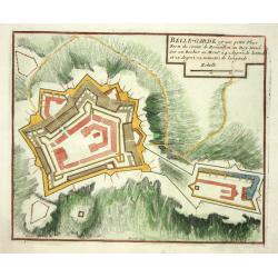
Belle-Garde.
Nice fortification plan of Belle-Garde in the department of Aude.
Date: Paris 1705
Selling price: ????
Please login to see price!
Sold
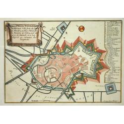
Winoxbergen.
Nice city plan of Winoxbergen in Flanders with the fortification walls.
Date: Paris 1705
Selling price: ????
Please login to see price!
Sold
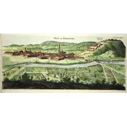
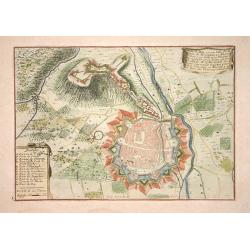
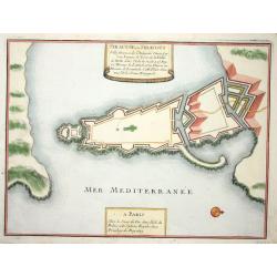
Veue de Fribourg.
Panoramic view of the fortified village of Freiburg in present-day Baden-Württemberg with the Dreisam in the foreground and the forts on the hills protecting the city.
Date: Paris 1705
Selling price: ????
Please login to see price!
Sold
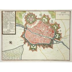
Tournay.
Nice city plan of Tournay in Flanders with the fortification walls and the citadel.
Date: Paris 1705
Selling price: ????
Please login to see price!
Sold
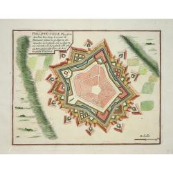
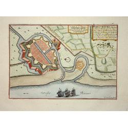
Philippe-ville.
Nice city plan of Philippe-Ville with the fortification walls.
Date: Paris 1705
Selling price: ????
Please login to see price!
Sold
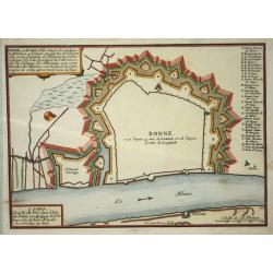
Bonn.
Nice map with Bonn at the Rhine-river.
Date: Paris 1705
Selling price: ????
Please login to see price!
Sold
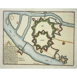
Manheim.
Nice map with Manheim at the Rhine-river.
Date: Paris 1705
Selling price: ????
Please login to see price!
Sold
(3 maps) Carte particuliere du Nouveau Canal. Versailles.
This map in three sheets illustrates the canal that would divert water from the Eure River at Pontgouin to Versailles. This massive project was designed by the great mili...
Date: Paris, 1705
Selling price: ????
Please login to see price!
Sold
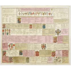
Tabula Historica et Geographica ad breve compendium..
An attractive instructional plate showing the coats-of-arms of various European countries, each with extensive key.
Date: Amsterdam, 1705
Selling price: ????
Please login to see price!
Sold
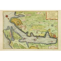
Le port et la ville de Mahon, le Bourg et le Fort St. Philippe..
Map encompassing the area between Mahon fort St. Philippe in Minorca. Wind rose in the upper left corner.Port Mahon is one of the world's finest natural harbors. During t...
Date: Paris, 1705
Selling price: ????
Please login to see price!
Sold in 2008
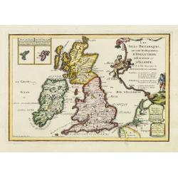
Les isles Britanique, ou sont les Royaumes d'Angleterre, d'Ecosse et d'Irlande. . .
The map includes British Isles, with insets of Ferro and Shetland Islands. Engraved by Vincent de Ginville. From his "Atlas Curieux", published 1700-1705, in th...
Date: Paris, 1705
Selling price: ????
Please login to see price!
Sold in 2011
Copenhague ...
Charming bird's-eye plan of the fortification of the city of Copenhagen.Nicolas de Fer held the title of Geographer at Louis XIV's court. He was one of the most prolific ...
Date: Paris, 1705
Selling price: ????
Please login to see price!
Sold in 2011
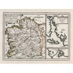
Royaume de Galice province d''Espagne. / Port et rade de Vigo.
Copper engraving by G. Inselin for Nicolas De Fer (1646-1720). Map is dated 1705. Three maps on one sheet. The left map reaches as far south as Caminha on the Miño river...
Date: Paris, 1705
Selling price: ????
Please login to see price!
Sold in 2008
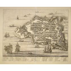
Valleta ou Valet Ville Forte de l''Isle De Malta
Map of the harbor and city of Valletta was originally published Joan Blaeu in the atlas "Theatrum Admiradorum...". Below the map an index referrers to 57 featur...
Date: Amsterdam, 1705
Selling price: ????
Please login to see price!
Sold in 2008
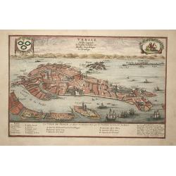
Venise
Attractive bird's-eye plan of Venice clearly depicting the city's landmarks and extending to the outlying islands including Murano. The surrounding lagoon is filled with ...
Date: Paris, 1705
Selling price: ????
Please login to see price!
Sold in 2008
Madrid
A city plan of Madrid with the surroundings. The map has a lot of details, like fields, trees, main buildings and defence walls.
Date: Paris, 1705
Selling price: ????
Please login to see price!
Sold in 2009
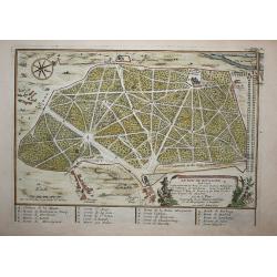
Le bois de Boulogne (Paris)
A print of Le bois de boulogne in Paris, detailed with paths walls trees and buildings and a compass rose.
Date: Paris, 1705
Selling price: ????
Please login to see price!
Sold in 2009
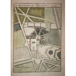
Le Menagerie de Versailles.
A print of a part of the garden of Versaille in Paris, detailed with paths, walls and trees.
Date: Paris, 1705
Selling price: ????
Please login to see price!
Sold in 2008
La Haie
Decorative plan of the Dutch city The Hague.
Date: Paris, 1705
Selling price: ????
Please login to see price!
Sold in 2009
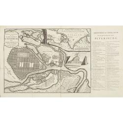
Grond - Tekening van de Russische Hoofdstadt St. Petersburg door Czaer Pieter de Eerste in 't jaer 1703 aengelegt.
Uncommon city plan of Saint Petersburg with keys to the right chart A-E, 1- 66. In upper right an inset map of the river Neva. Text is in Dutch.
Date: Utrecht, 1705
Selling price: ????
Please login to see price!
Sold in 2009
Madrid, Ville Considerable de la Nouvelle Castille, Sejour ordinaire des Roys d'Espagne. Par N. de Fer Geographe de Monseigneur le Dauphin.
Map of the city of Madrid, with a key: 1-26 in upper right corner. The city plan shows the geometric plant of the city, emphasizing the enclosure of old Villa and the Gre...
Date: Paris, 1705
Selling price: ????
Please login to see price!
Sold in 2009
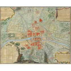
Quatrième plan de la ville de Paris son accroissement et l'etat ou elle êtoit sous le regne de Philipp Auguste...
Very interesting historic plan of Paris. Showing the buildings, city walls, fields and streets. Decorated with three cartouches and a compass rose. An extensive key indi...
Date: Paris, 1705
Selling price: ????
Please login to see price!
Sold in 2009
Les estats du duché de Milan.
Map of the states of the Duchy of Milan, taken from "Atlas Curieux", printed in Paris.
Date: Paris, 1705
Selling price: ????
Please login to see price!
Sold in 2009
Milan
Map of Milan, taken from "Atlas Curieux", printed in Paris.
Date: Paris, 1705
Selling price: ????
Please login to see price!
Sold in 2012
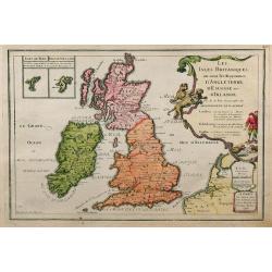
Les Isles Britanniques, ou sont les Royaumes d'Angleterre, d'Ecosse et d'Irlande.
This finely engraved map of the British Isles also has some detail of the adjacent French coast. The Fero and the Shetland Islands are included in small insets. Unusually...
Date: Paris, 1705
Selling price: ????
Please login to see price!
Sold in 2009
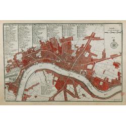
Plan des Villes de Londres et de Westminster et de leurs Faubourgs avec le Bourg de Southwark.
A rare engraving of London at the turn of the 17th/18th centuries engraved by C Inselin, stretching from Westminster Abbey in the west to Mile End in the east. A 113 poin...
Date: Paris, 1705
Selling price: ????
Please login to see price!
Sold in 2011