Browse Listings in Europe
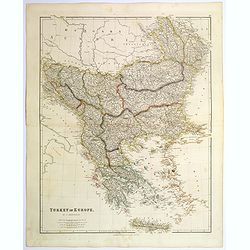
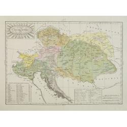
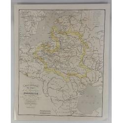
Turkey in Europe.
A large steel engraved map of Turkey in Europe, stretching from Croatia and Bosnia in the west across to the countries bordering the Black sea, southwards through mainlan...
Date: London, 1839
Selling price: ????
Please login to see price!
Sold in 2020
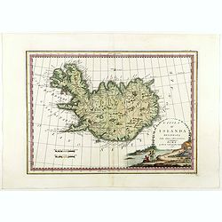
L'Isola d'Islanda Delineata Sulle ultime osservazioni.
Cassini’s splendid map depicts Iceland at the end of the eighteenth century. Though Iceland was geographically isolated from the European continent, for centuries it wa...
Date: Rome, 1796- before 1839
Selling price: ????
Please login to see price!
Sold in 2018
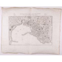
Nouveau Plan de la ville de Gênes corrigé de tous les changements faits jusqu'à ce jour.
Detailed plan of Genova., with in top a numbered key. Large margins.
Date: Genova, 1839
Selling price: ????
Please login to see price!
Sold in 2021
![[BALKANS 1839] HARTIS TIS TOYRKIAS KAI ELLADOS. . . BIENNI 1839.](/uploads/cache/85299-250x250.jpg)
[BALKANS 1839] HARTIS TIS TOYRKIAS KAI ELLADOS. . . BIENNI 1839.
A very rare copper engraved map of the southern Balkans - European Turkey and Greece, by K.M.Koyma, for the Greek edition of the Geography by A.Balbi, 1839 in Vienna. Cov...
Date: Vienna, 1839
Selling price: ????
Please login to see price!
Sold in 2021
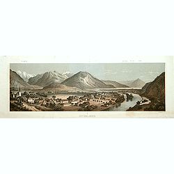
Interlaken.
Decorative panoramic view of the town of Interlaken, with in left hand corner the mountain Jung-Frau.Lithographed by Deroy.
Date: Paris, ca. 1840
Selling price: ????
Please login to see price!
Sold
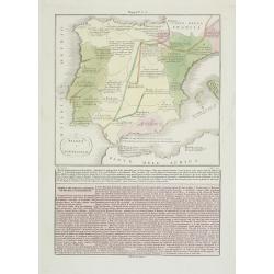
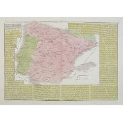
Spagna e Portugallo . . .
A rare map of ancient Spain and Portugal.From l'Atlante Storico, Letterario, Biografico, Archeologico. . . with attributions by Giambatista Albrizzi.Engraved by P.Zulian...
Date: Venice, 1840
Selling price: ????
Please login to see price!
Sold in 2009
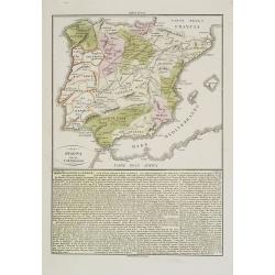
La Spagna ed il Portugallo. . .
A rare map of ancient Spain and Portugal.From l'Atlante Storico, Letterario, Biografico, Archeologico. . . with attributions by Giambatista Albrizzi.Engraved by P.Zulian...
Date: Venice, 1840
Selling price: ????
Please login to see price!
Sold in 2009
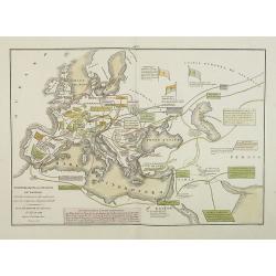
Transmigrazioni ed invasioni de\' Barbari . . .
A rare double-page map of Barbarian invasion.According to the title cartouche, prepared by A de La Sage for l\'Atlante Storico, Letterario, Biografico, Archeologico. . . ...
Date: Venice, 1840
Selling price: ????
Please login to see price!
Sold in 2009

Tour d'Observation et siège de police dans la grande Morskoi. (2 Juillet 1839).
A view of Observation Tower and police headquarters in the Morskoi in Saint Petersburg on August 9 1839. Plate taken from the first illustrated account of Russian archite...
Date: Paris, 1840
Selling price: ????
Please login to see price!
Sold in 2013
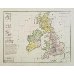
La Gran Brettagna . . . .
A rare and detailed double-page map of Great Britain with three inset maps upper left of the Shetland Mainland Islands, the Helgoland Island (occupied by the English in 1...
Date: Venice, 1840
Selling price: ????
Please login to see price!
Sold in 2011
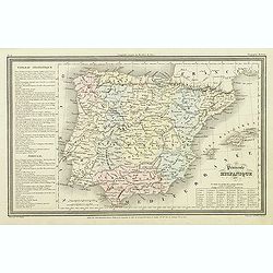
Spagna e Portogallo.
A rare and detailed double-page map of Spain and Portugal, showing the battlefields during the years 1817 until 1814. The map is surrounded by an explanatory historical t...
Date: Venice, 1840
Selling price: ????
Please login to see price!
Sold in 2009
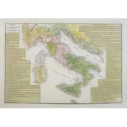
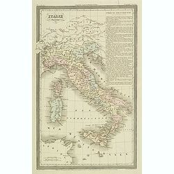
L'Italia ripartita a diversi dominii, in forza delli trattati di pace ottenuti dall' impero francese, conquiso al 1815.
A rare and detailed double-page map of Italy around the year 1815. The map is surrounded by an explanatory historical text about the country in a yellow background color....
Date: Venice, 1840
Selling price: ????
Please login to see price!
Sold in 2017
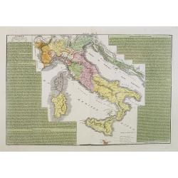
L'Italia dopo le prime guerre del secolo XVIII, eipartita dal vantato equilibrio europeo, sino al 1789.
A rare and detailed double-page map of Italy during the years 1748 - 1795. The map is surrounded by an explanatory historical text about the country in a yellow backgroun...
Date: Venice, 1840
Selling price: ????
Please login to see price!
Sold in 2023
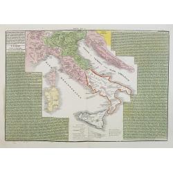
L'Italia suddivisa ne'varii stati che la dominavano circa al 1700.
A rare and detailed double-page map of Italy around the year 1700. The map is surrounded by an explanatory historical text about the country in a green background color.F...
Date: Venice, 1840
Selling price: ????
Please login to see price!
Sold in 2017
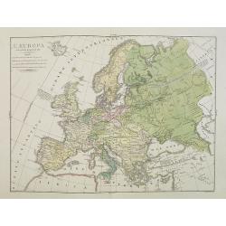
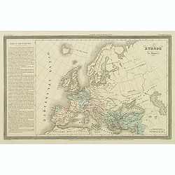
L'Europa colle politiche divisioni nel 1827.
A rare and detailed double-page map of Europe. From l'Atlante Storico, Letterario, Biografico, Archeologico. . . with attributions by Giambatista Albrizzi.Upper left a k...
Date: Venice, 1840
Selling price: ????
Please login to see price!
Sold in 2009
Regno Lombardo-Veneto parte dell' Impero Austriaco.
A rare and detailed double-page map of Northern Italy. From l'Atlante Storico, Letterario, Biografico, Archeologico. . . with attributions by Giambatista Albrizzi.Engrav...
Date: Venice, 1840
Selling price: ????
Please login to see price!
Sold in 2009
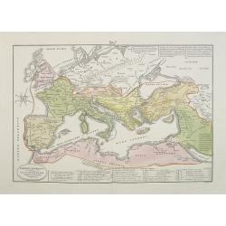
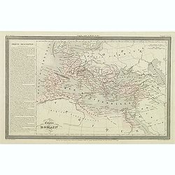
Impero Romano . . .
A rare double-page map of the Roman Empire. From l'Atlante Storico, Letterario, Biografico, Archeologico. . . with attributions by Giambatista Albrizzi.Lower part a key....
Date: Venice, 1840
Selling price: ????
Please login to see price!
Sold in 2009
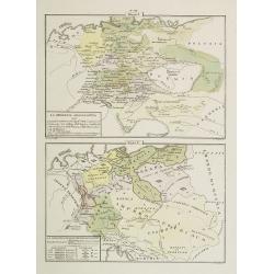
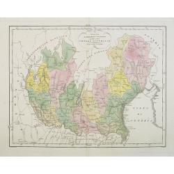
La Germania Legislativa . . . / La Germania ne' suoi principali dominii . . .
Two rare maps of Germany: Top map: 160 x 235mm. Bottom map: 155 x 230mm.Prepared by Las Casas for l'Atlante Storico, Letterario, Biografico, Archeologico. . . with attri...
Date: Venice, 1840
Selling price: ????
Please login to see price!
Sold in 2022

Château de Rustephan. (Bretagne).
A view of the ruin of Rustephan Castle. Made "after nature" by Serda in 1837.
Date: Paris, ca. 1840
Selling price: ????
Please login to see price!
Sold in 2009

Eglise et cimetière a St. Marc. (Bretagne).
A view of the cemetery of St. Marc in Bretagne. Made "after nature" by Serda in 1837. Lithographed by Vulleneuve.
Date: Paris, ca. 1840
Selling price: ????
Please login to see price!
Sold in 2009
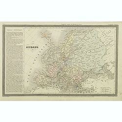
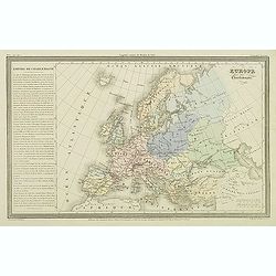
Europe.
Finely engraved map of Europe prepared by A.H.Dufour and engraved by Giraldon-Bovinet. Published by Jules Renouard in his uncommon atlas "Le globe Atlas classique Un...
Date: Paris, Jules Renouard, ca.1840
Selling price: ????
Please login to see price!
Sold in 2015
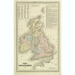
Iles Britanniques.
Finely engraved map of British Isles prepared by A.H.Dufour and engraved by Giraldon-Bovinet. Published by Jules Renouard in his uncommon atlas "Le globe Atlas class...
Date: Paris, Jules Renouard, ca.1840
Selling price: ????
Please login to see price!
Sold in 2011
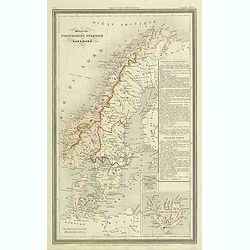
Monarchie Norvegieno Suedoise et Danemark.
Finely engraved map of Scandinavia, including Norway, Sweden, Denmark with insets of Iceland and Faroe Islands, prepared by A.H.Dufour and engraved by Giraldon-Bovinet. P...
Date: Paris, Jules Renouard, ca.1840
Selling price: ????
Please login to see price!
Sold in 2012
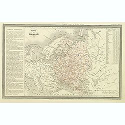
Empire de Russie.
Finely engraved map of Russia prepared by A.H.Dufour and engraved by Giraldon-Bovinet. Published by Jules Renouard in his uncommon atlas "Le globe Atlas classique Un...
Date: Paris, Jules Renouard, ca.1840
Selling price: ????
Please login to see price!
Sold in 2012
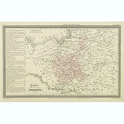
Royaume de Pologne.
Finely engraved map of Poland prepared by A.H.Dufour and engraved by Giraldon-Bovinet. Published by Jules Renouard in his uncommon atlas "Le globe Atlas classique Un...
Date: Paris, Jules Renouard, ca.1840
Selling price: ????
Please login to see price!
Sold in 2011
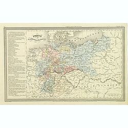
Prusse et confédération Germanique.
Finely engraved map of Prussia and part of Poland prepared by A.H.Dufour and engraved by Giraldon-Bovinet. Published by Jules Renouard in his uncommon atlas "Le glob...
Date: Paris, Jules Renouard, ca.1840
Selling price: ????
Please login to see price!
Sold in 2011
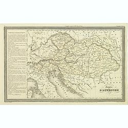
Empire d'Autriche.
Finely engraved map of Austria prepared by A.H.Dufour and engraved by Giraldon-Bovinet. Published by Jules Renouard in his uncommon atlas "Le globe Atlas classique U...
Date: Paris, Jules Renouard, ca.1840
Selling price: ????
Please login to see price!
Sold in 2011
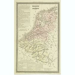
Hollande et Belgique.
Finely engraved map of the Netherland, Belgium and Luxemburg, prepared by A.H.Dufour and engraved by Giraldon-Bovinet. Published by Jules Renouard in his uncommon atlas &...
Date: Paris, Jules Renouard, ca.1840
Selling price: ????
Please login to see price!
Sold in 2011
Péninsule hispanique.
Finely engraved map of Spain and Portugal, including Majorca, Menorca and Ibiza, prepared by A.H.Dufour and engraved by Giraldon-Bovinet. Published by Jules Renouard in h...
Date: Paris, Jules Renouard, ca.1840
Selling price: ????
Please login to see price!
Sold in 2018
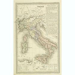
Italie.
Finely engraved map of Italy, including Sardinia and Corsica prepared by A.H.Dufour and engraved by Giraldon-Bovinet. Published by Jules Renouard in his uncommon atlas &q...
Date: Paris, Jules Renouard, ca.1840
Selling price: ????
Please login to see price!
Sold in 2012
Italie ancienne.
Finely engraved map of Italy prepared by A.H.Dufour and engraved by Giraldon-Bovinet. Published by Jules Renouard in his uncommon atlas "Le globe Atlas classique Uni...
Date: Paris, Jules Renouard, ca.1840
Selling price: ????
Please login to see price!
Sold in 2012
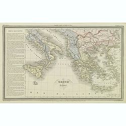
Grèce et ses colonies.
Finely engraved map of Greece, including Macedonia and lower part of Italy, prepared by A.H.Dufour and engraved by Giraldon-Bovinet. Published by Jules Renouard in his un...
Date: Paris, Jules Renouard, ca.1840
Selling price: ????
Please login to see price!
Sold in 2011
Empire romain.
Finely engraved map prepared by A.H.Dufour and engraved by Giraldon-Bovinet. Published by Jules Renouard in his uncommon atlas "Le globe Atlas classique Universel de...
Date: Paris, Jules Renouard, ca.1840
Selling price: ????
Please login to see price!
Sold in 2016
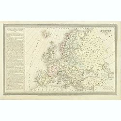
Europe après l'invasion des Barbares.
Finely engraved map prepared by A.H.Dufour and engraved by Giraldon-Bovinet. Published by Jules Renouard in his uncommon atlas "Le globe Atlas classique Universel de...
Date: Paris, Jules Renouard, ca.1840
Selling price: ????
Please login to see price!
Sold in 2016
Europe sous Charlemagne.
Finely engraved map prepared by A.H.Dufour and engraved by Giraldon-Bovinet. Published by Jules Renouard in his uncommon atlas "Le globe Atlas classique Universel de...
Date: Paris, Jules Renouard, ca.1840
Selling price: ????
Please login to see price!
Sold in 2015
Europe sous Charlemagne.
Finely engraved map prepared by A.H.Dufour and engraved by Giraldon-Bovinet. Published by Jules Renouard in his uncommon atlas "Le globe Atlas classique Universel de...
Date: Paris, Jules Renouard, ca.1840
Selling price: ????
Please login to see price!
Sold in 2016
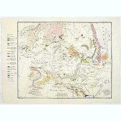
Sketch, to serve as a Basis for a Geological Map of European Russia, colored to show the connections of its Strata with those of the Surrounding Countries.
Uncommon geological map of Russia. Lithographed by B.R.Baker and printed by C.Hullmandel. From "Transactions of the Geographical Society".' With color key to th...
Date: Transactions of the Geological Society c. 1840
Selling price: ????
Please login to see price!
Sold in 2011
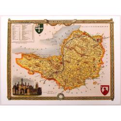
Somersetshire.
Nice hand-colored map of Somersetshire with a fine engraving cartouche of Glastonbury Cross. It also has two coats of arms. Thomas Moule (1784 - January 1851) was an Eng...
Date: London, 1840
Selling price: ????
Please login to see price!
Sold in 2013
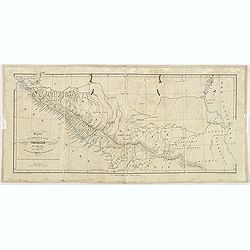
Carte pour l'intelligence du journal d'une résidence en Circassie during the years 1837, 1838 and 1839.
Map of Circassia prepared by James Stanislaus Bell. Engraved by Barriére, 57 rue de la Harpe, Paris. James Stanislaus Bell was a British merchant. In his work Journal of...
Date: Paris, Arthus Bertrand, after 1840
Selling price: ????
Please login to see price!
Sold in 2013
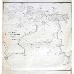
Carte de la rade de Plymouth avec le Môles excuté par l. ingénieur John Renie.
Rare sea-chart of the Plymouth Sound, engraved by Edler. With numerous depth soundings, shoals, buoys, and important landmarks including relevant buildings such as: Tarpo...
Date: unknown, c1840
Selling price: ????
Please login to see price!
Sold in 2018
L'Impero Austriaco . . .
A rare and detailed double-page map of Austrian Empire, including Northern Italy, Hungary, Czech Republic, etc. From l'Atlante Storico, Letterario, Biografico, Archeologi...
Date: Venice, 1840
Selling price: ????
Please login to see price!
Sold in 2014

S.Marco.
Lithography in original colors of the basilica San Marco in Venice. The Patriarchal Cathedral Basilica of Saint Mark (officially known in Italian as the Basilica Cattedra...
Date: Venise, c. 1840
Selling price: ????
Please login to see price!
Sold in 2017
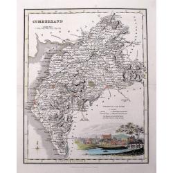
Cumberland.
Highly detailed map of the county, with a nice view of Carlisle shown from the North East. The map shows towns and villages, streets, lakes, rivers, forests, hills, etc. ...
Date: Glasgow, c1840
Selling price: ????
Please login to see price!
Sold in 2016
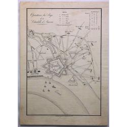
Operations du Siege de la Citadelle d'Anvers.
A fine engraving of the siege of Antwerp, Belgium in 1832. The citadel of Antwerp, also known as the South Castle, is a citadel and fortress which was located to the sout...
Date: Amsterdam, ca. 1840
Selling price: ????
Please login to see price!
Sold in 2019
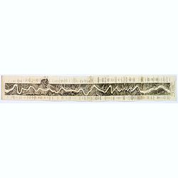
Panoramic Map of the Rhine from Cologne to Meyence.
A lovely long panoramabird's eye viewshowing the route from Cologne to Meyence, engraved to accompany Tombleson's view books on the Upper Rhine. Panorama is flanked on ei...
Date: London, ca. 1840
Selling price: ????
Please login to see price!
Sold in 2018
Carte Generale des Etats de la Republique Polonaise.
Original map on steel, engraved by A. Marcinkiewicz after Léonard Chodzko. It shows the expeditions of Varles XII at the beginning of the 18th century.Leonard Chod&#...
Date: Paris, 1840
Selling price: ????
Please login to see price!
Sold in 2018

Südlicher theil des Heidelberg schlosses . . . Façade du midi du château de Heidelberg . . .
Early aquatint after Louis Charles François de Graimberg-Belleau. Lithographed by Hibon and Paul Legrand.French artist. Son of Gilles-François Belleau Graimberg. Louis ...
Date: Graimberg, Heidelberg, ca. 1840
Selling price: ????
Please login to see price!
Sold in 2018

Westlicher theil des Heidelberg schlosses . . . Façade de l'ouest du château de Heidelberg . . .
Earlyaquatint after Louis Charles François de Graimberg-Belleau. Lithographed by Hibon and Paul Legrand.French artist. Son of Gilles-François Belleau Graimberg. Louis C...
Date: Graimberg, Heidelberg, ca. 1840
Selling price: ????
Please login to see price!
Sold in 2018
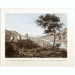
Ansicht des schlosses, der stradt u. des thales von Heidelberg . . . Vue du château, de la ville et du vallon de Heidelberg . . .
Early aquatint after Louis Charles François de Graimberg-Belleau. Lithographed by Salathé.French artist. Son of Gilles-François Belleau Graimberg. Louis Charles Franç...
Date: Graimberg, Heidelberg, ca. 1840
Selling price: ????
Please login to see price!
Sold in 2018
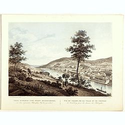
Thal schloss und stadt Heidelberg . . . Vue du vallon, de la ville et du château de Heidelberg . . .
Early lithographs after Louis Charles François de Graimberg-Belleau. Lithographed by Salathé.French artist. Son of Gilles-François Belleau Graimberg. Louis Charles Fra...
Date: Graimberg, Heidelberg, ca. 1840
Selling price: ????
Please login to see price!
Sold in 2018
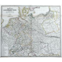
Map of the Germanic Confederated States, including the Kingdom of Prussia, as Settled by the Act of Congress at Vienna, June 9th 1815.
Large and detailed map of central Europe. From France until Poland, Russia, Lithuania and Hungary. And from Denmark until Venice and Belgrade. With areas, roads, rivers, ...
Date: London, c1840
Selling price: ????
Please login to see price!
Sold in 2020
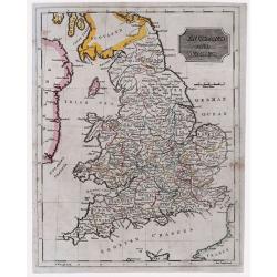
England & Wales.
Highly detailed map of England & Wales. The map provides good topographic details. The title is inside a frame-style cartouche. By F.W. Topham in London in 1840.
Date: London, 1840
Selling price: ????
Please login to see price!
Sold in 2021
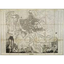
Plan topographique de Rome moderne Avec les changemens .. par Pl. Letarouilly architecte.
Astonishingly detailed and wonderful engraved dissected folding-map of Rome. Note the large vignette scenes. Stunningly detailed and engraved, with indexes at either side...
Date: Paris, 1841
Selling price: ????
Please login to see price!
Sold in 2008
![[Three S.D.U.K. Scandinavian Maps.]](/uploads/cache/96036-250x250.jpg)
[Three S.D.U.K. Scandinavian Maps.]
Three Scandinavian SDUK maps including:1) Denmark and part of Norway.2) The southern Provinces of Sweden (Sverige).3) Sweden, Norway and Denmark.Published by the "So...
Date: London, 1841
Selling price: ????
Please login to see price!
Sold in 2016
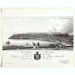
Vue de Monaco du côté du nord . . .
Extremely rare lithographed view of Monaco seen from the north side, lithographed by Jean Baptiste François Bosio, born June 17, 1764 in Monaco, and died July 6, 1827 in...
Date: Monaco, 1841
Selling price: ????
Please login to see price!
Sold
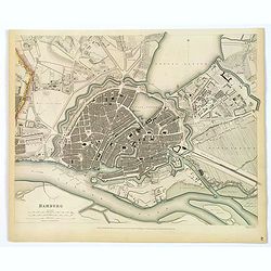
Hamburg.
An appealing plan of the important northern German port city of Hamburg. It is a nice detailed central town plan including its many canals, streets, buildings, and other ...
Date: London, 1841
Selling price: ????
Please login to see price!
Sold in 2019

Moscou (Vue de la Basilique St. Basile).
View of the St. Basil Basilica in Moscow. Engraved by Rouargue.Also called the Cathedral of Saint Basil the Blessed, this basilica is a multi-tented church on the Red Squ...
Date: Paris, 1842
Selling price: ????
Please login to see price!
Sold in 2009

St. Pétersbourg.
View of St. Petersburg during winter time, with in background St Isaac's Square with Saint Isaac's Cathedral or Isaakievskiy Sobor. It was the largest cathedral (sobor) i...
Date: Paris, 1842
Selling price: ????
Please login to see price!
Sold in 2009
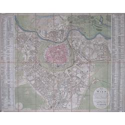
(Vienna) Plan von Wien Und Dessen Vorstädten ... / Plan De Vienne et ses faxbourgs ...
Large folding plan of Vienna divided into numbered and lettered squares, corresponding indices to left and right edges. Original wash color. The whole dissected into thir...
Date: Vienna, Artaria et Comp., 1842
Selling price: ????
Please login to see price!
Sold in 2012
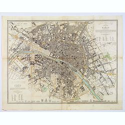
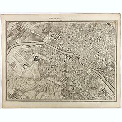
Western & Eastern Division Of Paris.
A detailed map of the French capital. Below it are 21 outlined perspectives of the iconic and important buildings and monuments within the city. Western and Eastern Quart...
Date: London, 1842
Selling price: ????
Please login to see price!
Sold in 2018
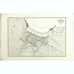
Plan de Reykjavík.
Detailed plan of Reykjavík from 'Voyage en Islande et au Groenland' by M. Paul Gaimard, published in Paris 1842. Engraved by Ambroise Tardieu' after 'V. Lottin'. Paul Ga...
Date: Paris, 1842
Selling price: ????
Please login to see price!
Sold in 2019
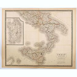
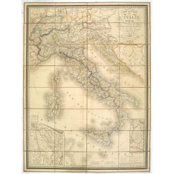
Italy South Part.
An attractive large map showing the Southern part of Italy including the islands of Sicily and Sardinia. Published in Edinburgh in Johnson's National Atlas..Nice detail, ...
Date: Edinburgh, 1842
Selling price: ????
Please login to see price!
Sold in 2020

Hôtel-de-ville de Gand
Beautiful hand-colored lithograph of the Ghent city hall, by Gustave Adolphe Simonau.One of Europe's greatest nineteenth century architectural artists, Gustave Adolphe Si...
Date: Brussels, 1843
Selling price: ????
Please login to see price!
Sold in 2009
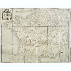
Carte des routes de poste de France dressée par ordre de Mr Conte, Conseiler d'Etat Directeur de l'administration et Président du conseil des Postes.
This post road maps map of France is showing incredible detail of the postal roads, stations (or "stages"), and the distances from town to town. Lower right, a ...
Date: Paris, 1843
Selling price: ????
Please login to see price!
Sold
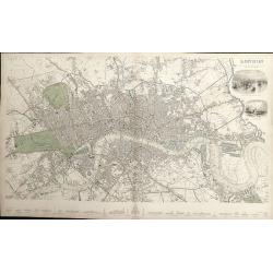
London.
A detailed plan of London, from Kensington to the East India Docks and Battersea to Holloway. Decorated with two vignettes of the Tower of London and a view of St.Paul's....
Date: London, 1843
Selling price: ????
Please login to see price!
Sold in 2012
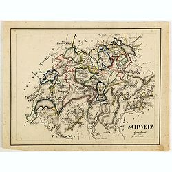
Schweiz gezeichnet von G.Asbach.
Fine manuscript map of Switzerland.
Date: Germany, ca. 1843
Selling price: ????
Please login to see price!
Sold in 2018
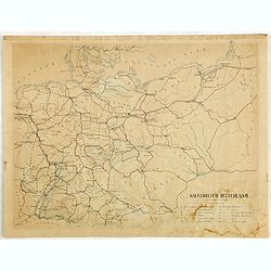
Kaiserreich Deutschland.
Fine manuscript map of The German Empire, which was the historical German nation state that existed from the unification of Germany in 1871 to the abdication of Kaiser Wi...
Date: Germany, ca. 1843
Selling price: ????
Please login to see price!
Sold in 2018
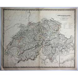
Switzerland (Die Schweiz ; La Suisse)
Large striking map of Switzerland by W & A.K. Johnston in Edinburgh in 1843. It definitely shows the high level of mountains in the country. It features an insert of ...
Date: Edinburgh, 1843
Selling price: ????
Please login to see price!
Sold in 2017
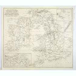
Map Exhibiting the Navigable Rivers, the completed & proposed Canals, & Rail-Roads of Great Britain & Ireland. . .
A large folded map of the navigable rivers, plus the existing or proposed canals and railways of G.B. & Ireland, originally published in London, but this example is p...
Date: New York, 1843
Selling price: ????
Please login to see price!
Sold in 2019
Geological Map of England and Wales . . .
Fascinating geological map of England and Wales.
Date: London, 1843
Selling price: ????
Please login to see price!
Sold in 2020
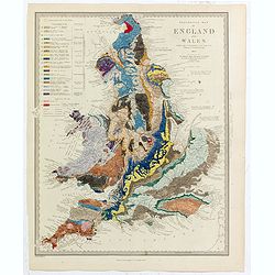
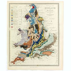
Geological Map of England and Wales . . .
Fascinating geological map of England and Wales, hand colored to reflect 20 different geological regions, with a color code on the left side of the plate.The map was prep...
Date: London, 1843
Selling price: ????
Please login to see price!
Sold in 2022

Plan von St. Petersburg.
Bird's-eye view of St. Petersburg with 18 engraved vignettes of buildings throughout the great city. The map and bridge view are from the 1834 map by the Society for the ...
Date: Amsterdam, Paris, and Philadelphia, 1844
Selling price: ????
Please login to see price!
Sold

Palais de Paul 1er. Côté du Jardin d'Eté. (16 Juillet 1839).
A view of Paul the First Palace in Saint Petersburg on August 9 1839. Figures are lithographed by Raffet. Plate taken from the first illustrated account of Russian archit...
Date: Paris, 1844
Selling price: ????
Please login to see price!
Sold in 2025
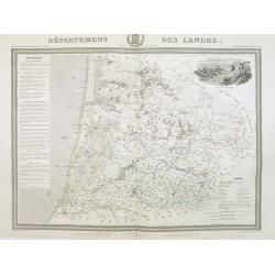
Département des Landes.
Detailed map of the Landes, with Bayonne in lower left corner. A panoramic view of Mont-de-Marsan upper right.. Text column of a detailed description of the geography, hi...
Date: Paris, 1844
Selling price: ????
Please login to see price!
Sold

Western Siberia, Independent Tartary , Khivam, Bokhara, etc.
Detailed map of a little explored region of Russia. From the Russian Lapland to Bokhara and from the Caspian Sea to Yeniseisk. Insert Maps of nova Zemblia and Yeniseisk....
Date: London, 1844
Selling price: ????
Please login to see price!
Sold in 2014
Carte routiére d'Italie indiquant les divisions politiques de ses divers états . . .
Scarce folding map of Italy, Switzerland and Austria. In lower right inset plan "Route de Lyon à Marseille conduisant à celle de Nice." and "Routes de Pa...
Date: Paris, 1844
Selling price: ????
Please login to see price!
Sold in 2023
Plan de Paris Par Roussel Caqpt. Ingénieur en 1700.
Plan of the center of Paris by Claude Roussel (1655-172.?). here in a later reprint from around 1844.
Date: Paris, after or ca. 1844
Selling price: ????
Please login to see price!
Sold

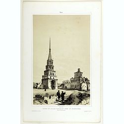
Entrée Méridionale et Tour dite des Saints.
A view of Troïtza Monastery near Moscow. Raffet lithographs figures. Plate taken from the first illustrated account of Russian architecture. This publication was the pro...
Date: Paris, 1844
Selling price: ????
Please login to see price!
Sold
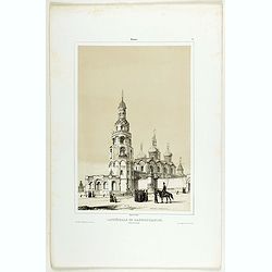
Ruines du Palais Tartare et Tour de Soumbecka intérieur de la Forteresse.
A view of the Tartar Palace's ruins and Soumbecka's tower in Kazan in southwest Russia, on the banks of the Volga and Kazanka rivers. Figures are lithographed by Raffet. ...
Date: Paris, 1844
Selling price: ????
Please login to see price!
Sold in 2019
Cathédrale de l'Annonciation ( Blakovestchensky).
A view of l'Annonciation cathedral. Figures are lithographed by Raffet. Plate taken from the first illustrated account of Russian architecture. This publication was the p...
Date: Paris, 1844
Selling price: ????
Please login to see price!
Sold in 2019