Browse Listings in Europe
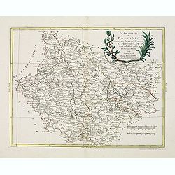
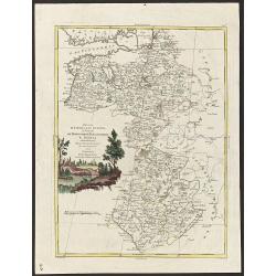
Li Palatinati di Posnania, Gniesno, Brzesc, Kalisz, e Inowroclaw. . .
A attractive and detailed map of part of Western part of Poland centered on Poznan. The decorative and large pictorial title cartouche is fully colored.Published in Zatta...
Date: Venice, 1782
Selling price: ????
Please login to see price!
Sold in 2012
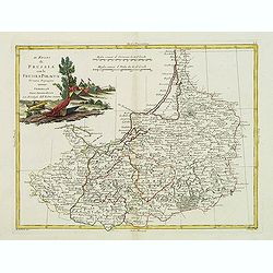
Il Regno di Prussia co la Prussia Polacca. . .
A attractive and detailed map of northern region of Poland including the city of Gdansk on the Baltic coast. The decorative and large pictorial title cartouche is fully c...
Date: Venice, 1782
Selling price: ????
Please login to see price!
Sold in 2012
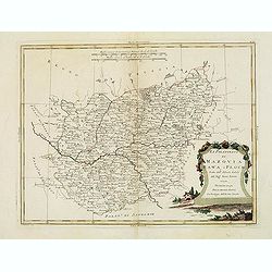
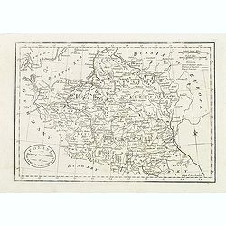
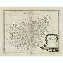
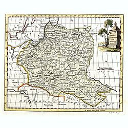
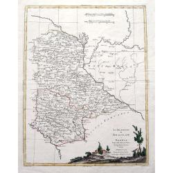
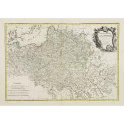
Li Palatinati di Mazovia, Rawa, e Plock, Tratta dall' Atlante Polaco del Sig. . .
A attractive and detailed map of cental Poland including the city of Warsaw. The decorative and large pictorial title cartouche is fully colored.Published in Zatta's' Atl...
Date: Venice, 1782
Selling price: ????
Please login to see price!
Sold in 2012
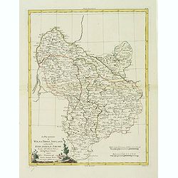
Li Palatinati di Wilna, Troki, Inflant, coi Ducati di Kurlandia, e Smudz. . .
A attractive and detailed map Latvia and northern Lithuania, marking Vilnius (Wilno), Riga and many other towns.. The decorative and large pictorial title cartouche is fu...
Date: Venice, 1782
Selling price: ????
Please login to see price!
Sold in 2012
Poland, Shewing the Claims of Austria, Russia & Prussia.
Uncommon map of Poland and Lithuania engraved by J. Cary. Originally published by J.Fielding. Here from the "Complete Geographical Dictionary" by John Seally. T...
Date: London, after 1782
Selling price: ????
Please login to see price!
Sold in 2015
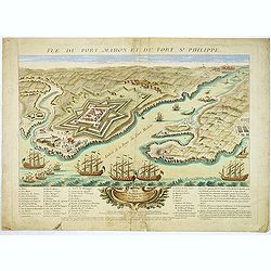
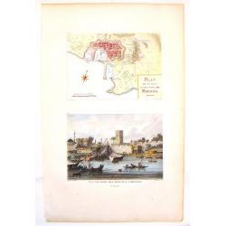
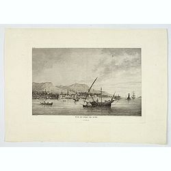
Vue du Port-Mahon et du fort S. Philippe de l'ile Minorque.
A very RARE panoramic of Mahón on Minorca, including a lettered legend in the lower part.The view represents the Fort San Felipe, with its arsenal and batteries, and th...
Date: Paris, ca.1782
Selling price: ????
Please login to see price!
Sold
Li Palatinati di Mazovia, Rawa, e Plock, Tratta dall' Atlante Polaco del Sig. . .
A attractive and detailed map of central Poland including the city of Warsaw. The decorative and large pictorial title cartouche is fully colored.Published in Zatta's' At...
Date: Venice, 1782
Selling price: ????
Please login to see price!
Sold in 2016
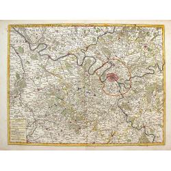
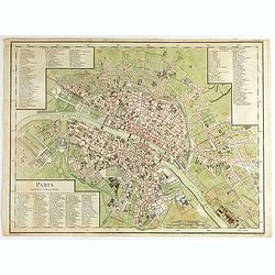
Carte de la Prevoste et Vicomte de Paris.
The large very detailed map of Paris was originally created by Guilliame Deslise or De L'Isle (1675-1726). Delisle is best known for his changes to cartography that resul...
Date: Paris, 1782
Selling price: ????
Please login to see price!
Sold in 2013
Plan de la ville et des Ports de Rhodes & Vue du Port des Bateaux a Rhodes.
Two detailed steel engraved prints of Rhodes on one sheet. Features an overhead view of the fortification as well as a view of the ships at port. ByCompte de Choiseul-G...
Date: Paris, 1782
Selling price: ????
Please login to see price!
Sold in 2013
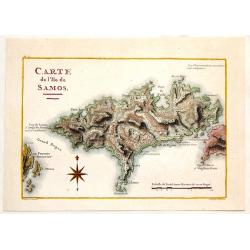
Carte de L\'Ile de Samos.
Fine copper engraved, hand-colored map of the Island of Samos in the Greek Islands. Marie-Gabriel-Florent-Auguste de Choiseul-Gouffier (1752-1817) was a member of the A...
Date: Paris, 1782
Selling price: ????
Please login to see price!
Sold in 2014
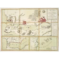
Nouveau Plan du port Mahon et du fort St Philipe Avec les Campements et les différentes Attaques des Troupes Françoises et Espagnoles. . .
A fine map of the Bay of Mahon with a key to the right "Remarques et Renvois du Plan". According to the tittle "Levé sur les Lieux Par les Ingénieurs Mil...
Date: Paris, ca. 1782
Selling price: ????
Please login to see price!
Sold in 2013
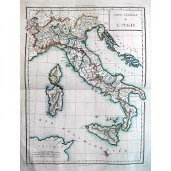
Carte Génerale de l'Italie.
Beautiful copper engraved map of Italy, including Malta, Corsica, and Sardinia. Probably published "Atlas nouveau" by Mentelle. An excellent example of this...
Date: Paris, c. 1782
Selling price: ????
Please login to see price!
Sold in 2013
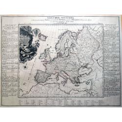
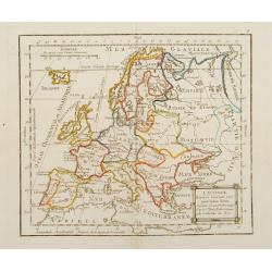
Neue Carte von Europa welche die merkwürdigsten Producte und vornehmsten Handelsplätze...
Rare thematic map showing Europe's economy. It illustrates 56 products and resources, including gold, copper, wine, fruit, salt, hemp, silk, horses, and so on. Nine furth...
Date: Dessau, 1782
Selling price: ????
Please login to see price!
Sold in 2016
Poland Lithuania and Prussia.
Uncommon miniature map of Poland, Lithuania and the Ukraine, engraved by Thomas Kitchin - with his signature in lower right bottom.
Date: London, 1782
Selling price: ????
Please login to see price!
Sold in 2014
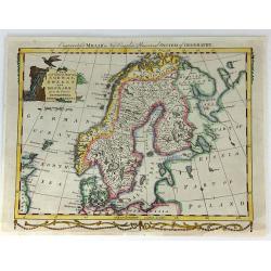
A New And Correct Map Of Norway, Sweden And Denmark. From The Latest Geographical Improvements
An attractive and interesting map, published for George Millar's "New and Universal System of Geography" - a Georgian compendium of reports and accounts from al...
Date: London, 1782
Selling price: ????
Please login to see price!
Sold in 2017
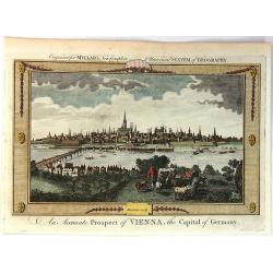
An Accurate Prospect of Vienna, the Capital of Germany.
A fine city view of Vienna, when it was the capital of Germany, not Austria. It is from "Millar's New Complete Universal System of Geography" published in Londo...
Date: London, 1782
Selling price: ????
Please login to see price!
Sold in 2018
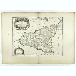
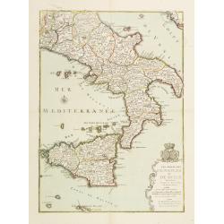
La Sicile divisee en ses trois povinces ou valees. . .
Fine map of Sicily with a decorative title and scale cartouche. The uncommon updated version by Louis Denis, dated 1782.Alexis-Hubert Jaillot (1632-1712), was a French ca...
Date: Paris, 1782
Selling price: ????
Please login to see price!
Sold in 2022
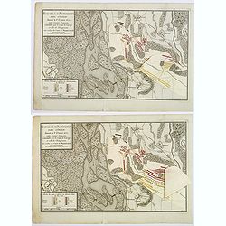
Baitaille d'Altenheim dans l'Ortnau donnee le 1st Aoust 1675. . .
A copperplate folding battle plan of Altenheim, on the east side of the river Rhine. With three pastedown overlays demonstrating the different positions of the French and...
Date: Paris, 1782
Selling price: ????
Please login to see price!
Sold in 2021
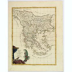
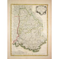
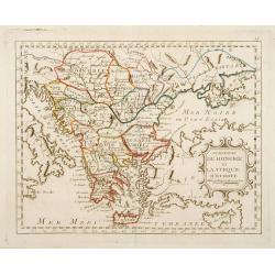
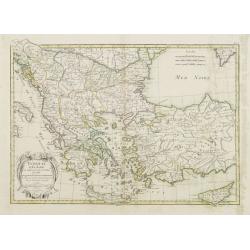
Turchia d'Europa divisa Nelle Sue Provincie, e Governi. . .
The pleasing map of the European provinces of the Ottoman Empire, by Antonio Zatta, published during the latter half of the eighteenth century. It shows the administrativ...
Date: Venice, 1782
Selling price: ????
Please login to see price!
Sold in 2021
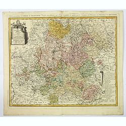
Der Fraenkische Kreis. . .
An attractive large map showing the Frankish Circle in Germany, centered on Bamberg. Each area is highlighted in a different color. With a nice title cartouche, with mile...
Date: Nuremberg, 1782
Selling price: ????
Please login to see price!
Sold in 2019
Vue du Port de Scio.
A delightful copperplate view of the port of the Greek island of Chios. It shows fishermen on their boats in the foreground, and the town and surrounding hills in the bac...
Date: Paris, 1782
Selling price: ????
Please login to see price!
Sold in 2019
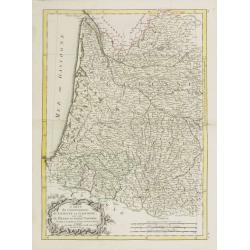
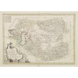
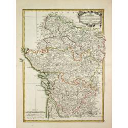
Ducati di Livonia, e di Estonia, e governi di Nowogorod, Bielogorod e Kiowia.
The nice map depicting vast territory of present days Estonia, Latvia, Belarus, Russian Federation and Ukraine. Those days territory belonged to Livonia, Polish-Lithuania...
Date: Venice, 1782
Selling price: ????
Please login to see price!
Sold in 2019
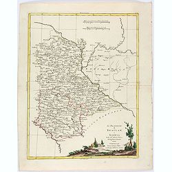
Li Palatinati di Braclaw e Kiowia. Tratta dall' Atlante Polacco del Sigr Rizzi Zanoni.
An excellent map of the areas of Braclaw (Bratslav), and Kijow (Kiev), west of the Dnieper river. With many place names and a large decorative title vignette.
Date: Venice, ca 1782
Selling price: ????
Please login to see price!
Sold in 2019
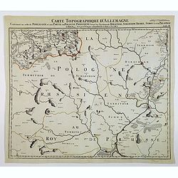
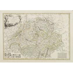
Carte Topographque D'Allemagne / Contenant un reste de Pomeranie et a Partie de la Pologne Prussiene . . .
A large-scale map of Germany and northern Poland, published by the German Military cartographer Johann Wilhelm Abraham Jaeger, from his Grand Atlas d'Allemagne.This map i...
Date: Frankfurt, 1782
Selling price: ????
Please login to see price!
Sold in 2021
Paris Superficie 5,280,000 Toises.
FIRST EDITION of this finely engraved plan of Paris by P. F. Tardieu and prepared by DuBuisson. This detailed plan of Paris includes la Place Louis XV, la Bastille, but d...
Date: Paris, 1779-1782
Selling price: ????
Please login to see price!
Sold in 2020
Li Palatinati di Braclaw, e Kiowia tratta dall'Atlante Polacco del Sig. Rizzi Zanoni.
An delightfully engraved map of West central Ukraine, including parts of the modern Oblasts of Kiev, Zhytomyr and Vinnytsia. Województwo Braclawskie, Kijowskie. Publishe...
Date: Venice, 1782
Selling price: ????
Please login to see price!
Sold in 2021
Carte des Gouvernements de Dauphine et de Provence.
Jean Lattré, Paris-based engraver and publisher. Worked with Robert de Vaugondy, J. Janvier and R. Bonne. " Atlas Monderne', 1771, 1783 , 1793. Rigobert Bonne (1727...
Date: Paris, 1783
Selling price: ????
Please login to see price!
Sold
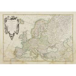
L\'Europe Divisée Suivant ses principaux Etats ..
Map of Europe prepared by de La Fosse and published by Monhare for his Atlas Général a l\'usage des colleges et maisons d\'education.. Louis Joseph Mondhare published s...
Date: Paris, 1783
Selling price: ????
Please login to see price!
Sold in 2009
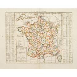
La France Divisée en IX Régions, 10 Métropoles, et 85 Départements ..
Rare map of France prepared after J.B.Nolin and published by Monhare for his Atlas Général a l'usage des colleges et maisons d'education.. Lower right inset map of Cors...
Date: Paris 1783
Selling price: ????
Please login to see price!
Sold
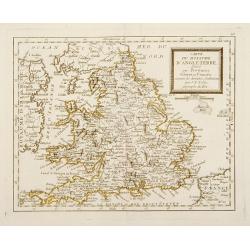
Carte du Royaume de l'Angleterre divisé par Provinces, Schires ou Comtés ..
Rare map of England prepared after J.B.Nolin and published by Monhare for his Atlas Général a l'usage des colleges et maisons d'education.. Louis Joseph Mondhare publis...
Date: Paris 1783
Selling price: ????
Please login to see price!
Sold
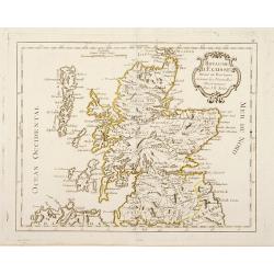
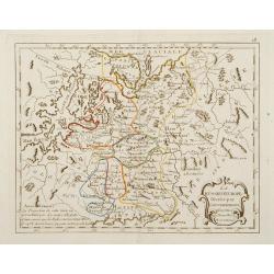
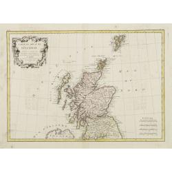
Royaume d'Ecosse Divisé en Provinces . . .
Rare map of Scotland prepared by J.B.Nolin and published by Monhare for his Atlas Général a l'usage des colleges et maisons d'education.. Louis Joseph Mondhare publishe...
Date: Paris, 1783
Selling price: ????
Please login to see price!
Sold in 2016
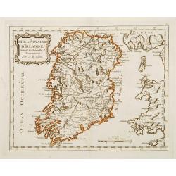
Isle et Royaume D'Irlande ..
Rare map of Ireland prepared by J.B.Nolin and published by Monhare for his Atlas Général a l'usage des colleges et maisons d'education.. Louis Joseph Mondhare published...
Date: Paris 1783
Selling price: ????
Please login to see price!
Sold
Carte des Provinces Unies Des Pays-Bas connüe sous le nom D'Hollande ..
Rare map of the Netherlands prepared by J.B.Nolin and published by Monhare for his Atlas Général a l'usage des colleges et maisons d'education.. Louis Joseph Mondhare p...
Date: Paris, 1783
Selling price: ????
Please login to see price!
Sold in 2022
Carte de la Suisses des Alliés des Suisses et de leurs Sujets ..
Rare map of Switzerland prepared by J.B.Nolin and published by Monhare for his Atlas Général a l'usage des colleges et maisons d'education.. Louis Joseph Mondhare publi...
Date: Paris, 1783
Selling price: ????
Please login to see price!
Sold in 2013
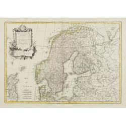
Les Royaumes De Suede Norwege et Danemark ..
Rare map of Scandinavia prepared by J.B.Nolin and published by Monhare for his Atlas Général a l'usage des colleges et maisons d'education.. With inset map of Lapland a...
Date: Paris, 1783
Selling price: ????
Please login to see price!
Sold in 2009
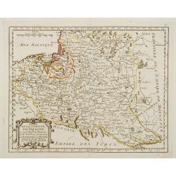
Etats de la Couronne de Pologne ousont les Roy de Pologne, le Gd. Duc de Lithuanie, La Russie noire, La Volhinie?
Rare map of Poland prepared by J.B.Nolin and published by Monhare for his Atlas Général a l'usage des colleges et maisons d'education.. Louis Joseph Mondhare published ...
Date: Paris, 1783
Selling price: ????
Please login to see price!
Sold
La Russie d'Europe Divisée par Gouvernemens Assujetties aux Nouvelles Observations..
Rare map of the European part of Russia, prepared by J.B.Nolin and published by Monhare for his Atlas Général a l'usage des colleges et maisons d'ed...
Date: Paris, 1783
Selling price: ????
Please login to see price!
Sold in 2009
Le Royaume de Hongrie et la Turquie d'Europe ..
Rare map of Greece and Hungary prepared by J.B.Nolin and published by Monhare for his Atlas Général a l'usage des colleges et maisons d'education.. Louis Joseph Mondhar...
Date: Paris, 1783
Selling price: ????
Please login to see price!
Sold
L'Italie Divisée en ses différents Etats Royaume et Républiques..
Rare map of Italy, prepared by J.B.Nolin and published by Monhare for his Atlas Général a l'usage des colleges et maisons d'education.. Louis Joseph Mondhare published ...
Date: Paris, 1783
Selling price: ????
Please login to see price!
Sold
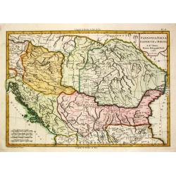
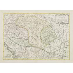
Pannonia, Dacia, Illyricum et Moesia. 1783.
Jean Lattré, Paris-based engraver and publisher. Worked with Robert de Vaugondy, J. Janvier and R. Bonne. " Atlas Monderne', 1771, 1783 , 1793. Rigobert Bonne (1727...
Date: Paris, 1783
Selling price: ????
Please login to see price!
Sold in 2018
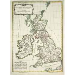
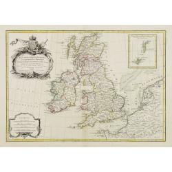
Insularum Britannicarum Tabula Geographica.
Jean Lattré, Paris-based engraver and publisher. Worked with Robert de Vaugondy, J. Janvier and R. Bonne. " Atlas Monderne', 1771, 1783 , 1793. Rigobert Bonne (1727...
Date: Paris, 1783
Selling price: ????
Please login to see price!
Sold in 2011
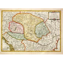
Le Royaume de Hongrie Divisé en Haute et Basse Hongrie Transylvanie Esclavonie et Croatie.
Jean Lattré, Paris-based engraver and publisher. Worked with Robert de Vaugondy, J. Janvier and R. Bonne. " Atlas Monderne', 1771, 1783 , 1793. Jean Janvier, French...
Date: Paris, 1783
Selling price: ????
Please login to see price!
Sold in 2010
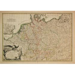
L\' Alemagne Divisée par Cercles.
Jean Lattré, Paris-based engraver and publisher. Worked with Robert de Vaugondy, J. Janvier and R. Bonne. " Atlas Monderne', 1771, 1783 , 1793. Giovanni Antonio Riz...
Date: Paris, 1783
Selling price: ????
Please login to see price!
Sold in 2009
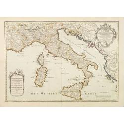
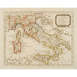
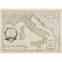
L'Italie.
Un uncommon re-issue by Desnos of this fine map of Italy, including Sardinia and Corsica. Prepared by Sanson and originally published by Jaillot.The map is colored in out...
Date: Paris 1783
Selling price: ????
Please login to see price!
Sold
Les Royaumes de Naples et de Sicile.
Un uncommon re-issue by Desnos of this fine map of Italy, including Sardinia and Corsica. Prepared by Sanson and originally published by Jaillot.The map is colored in out...
Date: Paris 1783
Selling price: ????
Please login to see price!
Sold
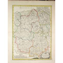
Carte des Gouvernements du Berri, du Nivernois, de la Marche, du Bourbonnois, du Limosin et de l\' Auvergne.
Jean Lattré, Paris-based engraver and publisher. Worked with Robert de Vaugondy, J. Janvier and R. Bonne. " Atlas Monderne', 1771, 1783 , 1793. Rigobert Bonne (1727...
Date: Paris, 1783
Selling price: ????
Please login to see price!
Sold in 2014
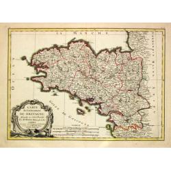
Carte du Gouvernement de Bretagne.
Jean Lattré, Paris-based engraver and publisher. Worked with Robert de Vaugondy, J. Janvier and R. Bonne. " Atlas Monderne', 1771, 1783 , 1793. Rigobert Bonne (1727...
Date: Paris, 1783
Selling price: ????
Please login to see price!
Sold
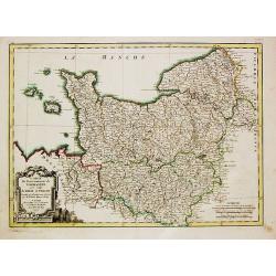
Carte du Gouvernement de Normandie avec celui du Maine et Perche.
Jean Lattré, Paris-based engraver and publisher. Worked with Robert de Vaugondy, J. Janvier and R. Bonne. "Atlas Monderne", 1771, 1783 , 1793. Rigobert Bonne (...
Date: Paris, 1783
Selling price: ????
Please login to see price!
Sold in 2018
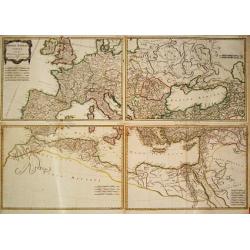
Imperii Romani Pars Occidentalis Superior / Inferior / Pars Orientalis superior / Inferior.
Jean Lattré, Paris-based engraver and publisher. Worked with Robert de Vaugondy, J. Janvier and R. Bonne. " Atlas Monderne', 1771, 1783 , 1793. Rigobert Bonne (1727...
Date: Paris, 1783
Selling price: ????
Please login to see price!
Sold
Carte du Gouvernement de Guienne et Gascogne.. Navarre..
Attractive map of the south western part of France delimited by the Garonneoutfall, the town of Toulouse and the Pyrenees.Decorated with a rococo title cartouche. Boundar...
Date: Paris, ca 1783
Selling price: ????
Please login to see price!
Sold
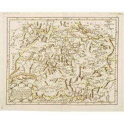
La Suisse divisée En Ses Treize Cantons Et Ses Alliés..
Attractive map of Switzerland, ornated with a rococo title cartouche. 24 coats of arms in the lower left corner. Boundaries outlined in hand color.From theAtlas moderne o...
Date: Paris, ca 1783
Selling price: ????
Please login to see price!
Sold
Carte Du Royame D'Ecosse..
Attractive map of Scotland, including the Shetland Islands. Decorated with a rococo title cartouche. Boundaries outlined in hand color.From theAtlas moderne ou collection...
Date: Paris, ca 1783
Selling price: ????
Please login to see price!
Sold
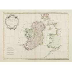
Carte D'Irlande..
Attractive map of Ireland, ornated with a rococo title cartouche. Boundaries outlined in hand color.From theAtlas moderne ou collection de cartes sur toutes les parties d...
Date: Paris, ca 1783
Selling price: ????
Please login to see price!
Sold
Carte de la Tartarie Indépendante qui comprend le Pays des Calmuks, celui des Usbeks, et le Turkestan..
Attractive map covering the area between the Caspian Sea and China. In lower right part Tibet ou Budian. Ornated with a decorative title cartouche. Boundaries outlined in...
Date: Paris, ca 1783
Selling price: ????
Please login to see price!
Sold in 2008
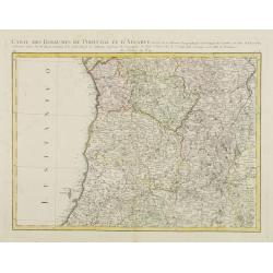
Carte des Royaumes de Portugal et D\'Algarve..
Map of the northern part of Portugal prepared by Giovanni Antonio Bartolomeo Rizzi Zannoni, one of the leading cartographers of the late 18th century, as well as being an...
Date: Paris, ca 1783
Selling price: ????
Please login to see price!
Sold in 2010
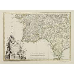
Mapa dos Reynos de Portugal e Algarve. . .
Map of the southern part of Portugal, including part of Spain and Gibraltar. The large decorative title cartouche presents the coat of arms surmounted by a crown, a repre...
Date: Paris, ca 1783
Selling price: ????
Please login to see price!
Sold in 2020

L'Allemagne Divisée par Cercles..
General map of central Europe, centered on Germany but including Poland, Belgium, the Netherlands, Switzerland, Austria and part of eastern Europe.Ornated with a decorati...
Date: Paris, ca 1783
Selling price: ????
Please login to see price!
Sold in 2016
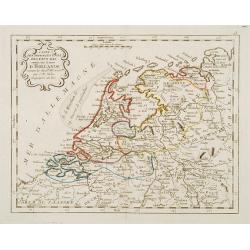
![[No title] Map of the Netherlands, Belgium and the north western part of Germany.](/uploads/cache/24262-250x250.jpg)
[No title] Map of the Netherlands, Belgium and the north western part of Germany.
Attractive map centered on the Netherlands, encompassing the area between Calais, Gottingen up to Denmark.Ornated with a cartouche containing a dedication to "S.E. M...
Date: Paris, ca 1783
Selling price: ????
Please login to see price!
Sold
Carte Generale de la Pologne avec tous les Etats qui en dependent..
Attractive map of Poland, ornated with a rococo title cartouche. Boundaries outlined in hand color.Prepared by Giovanni Antonio Bartolomeo Rizzi Zannoni, one of the leadi...
Date: Paris ca 1783
Selling price: ????
Please login to see price!
Sold
L'Europe divisée en ses principaux Etats..
Attractive map of Europe, ornated with a decorative title cartouche. Boundaries outlined in hand color.Prepared by Le Sieur Janvier, Jean denis [Robert], French geographe...
Date: Paris, ca 1783
Selling price: ????
Please login to see price!
Sold
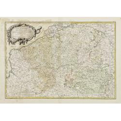
Partie Méridionale des Pays Bas, Comprenant les Provinces de Brabant, Gueldre, Lumbourg, Luxembourg..
Attractive map centered on Belgium, encompassing Luxembourg, part of France and the southern part of the Netherlands.ornated with a decorative title cartouche. Boundaries...
Date: Paris, ca 1783
Selling price: ????
Please login to see price!
Sold in 2008
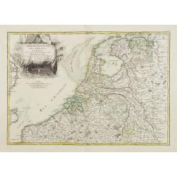
Partie Septentrionale des Pays Bas, Comprenant les Etats Généraux des Provinces Unies..
Very attractive map centered on the Netherlands. The title is included in the stern sail of a large Dutch vessel. Boundaries outlined in hand color.Prepared by Le Sieur J...
Date: Paris, ca 1783
Selling price: ????
Please login to see price!
Sold

Les Royaumes D'Espagne et de Portugal, divisés Par Grandes Provinces..
Attractive map of the Iberian Peninsula. Boundaries outlined in hand color.Ornated with a decorative title cartouche showing the coats of arms of Spain and Portugal.Prepa...
Date: Paris, ca 1783
Selling price: ????
Please login to see price!
Sold in 2023
L' Italie divisée en ses differents Etats Royaumes et republiques..
Attractive map of the Italian Peninsula, showing also Corsica and Malta. Boundaries outlined in hand color.Ornated with a decorative title cartouche presenting the symbol...
Date: Paris ca 1783
Selling price: ????
Please login to see price!
Sold
Le Royaume de Hongrie Divisé en Haute et Basse Hongrie..
Attractive map centered on Hungary, ornamented with a decorative title cartouche. Boundaries outlined in hand color.Prepared by Le Sieur Janvier, Jean denis [Robert], Fre...
Date: Paris, ca 1783
Selling price: ????
Please login to see price!
Sold in 2012
Les isles Britanniques comprenant les Royaumes d\'Angleterre d\'Ecosse et d\'Irlande..
Attractive map of the British Isles, ornated with a decorative title cartouche and a scale cartouche.With inset map including the Orcade and Shetland Islands. Boundaries ...
Date: Paris, ca 1783
Selling price: ????
Please login to see price!
Sold in 2008
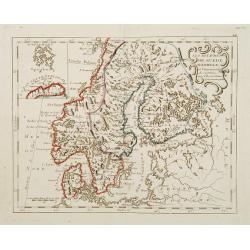
Les Couronnes du Nord comprenant les Royaumes de Suede Danemarck et Norwege..
Attractive map of Scandinavia, ornated with a decorative title cartouche. Boundaries outlined in hand color.Prepared by Le Sieur Janvier, Jean denis [Robert], French geog...
Date: Paris, ca 1783
Selling price: ????
Please login to see price!
Sold
Turquie d'Europe et partie de celle d'Asie..
Attractive map centered on the Aegean Sea, encompassing the whole Balkan Peninsula and part of Turkey.It includes also Crete and Cyprus. Decorated with a decorative title...
Date: Paris, ca 1783
Selling price: ????
Please login to see price!
Sold in 2011
Carte des Gouvernements de d' Anjou, et du Saumurois, de la Touraine, du Poitot, du Pays d' Aunis, Saintonge-Angoumois.
Jean Lattré, Paris-based engraver and publisher. Worked with Robert de Vaugondy, J. Janvier and R. Bonne. " Atlas Monderne', 1771, 1783 , 1793. Rigobert Bonne (1727...
Date: Paris, 1783
Selling price: ????
Please login to see price!
Sold in 2009
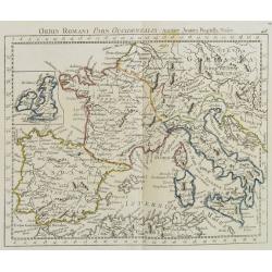
Orbis Romani Pars Occidentalis. . .
Map of the ancient Roman Empire, prepared by J.B.Nolin and published by Monhare for his Atlas Général a l\'usage des colleges et maisons d\'education.. Louis Joseph Mon...
Date: Paris, 1783
Selling price: ????
Please login to see price!
Sold in 2009
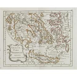
Graeciae Pars Meridionalis. . .
Rare map of Greece prepared by J.B.Nolin and published by Monhare for his Atlas Général a l'usage des colleges et maisons d'education.. Louis Joseph Mondhare was active...
Date: Paris, 1783
Selling price: ????
Please login to see price!
Sold in 2008
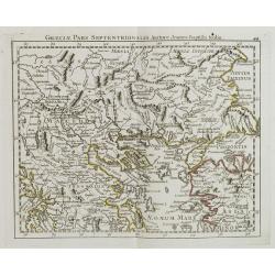
Graeciae Pars Septentrionalis?
Rare map of northern part of Greece, prepared by J.B.Nolin and published by Monhare for his Atlas Général a l'usage des colleges et maisons d'education.. Louis Joseph M...
Date: Paris, 1783
Selling price: ????
Please login to see price!
Sold in 2008
St. Petersbourg
Large city plan of St. Petersburg in Russia. From the Atlas Volume of \"Histoire physique, morale, civile et politique de la Russie Ancienne\" by N. G. Le Clerc...
Date: Paris, 1783
Selling price: ????
Please login to see price!
Sold in 2008
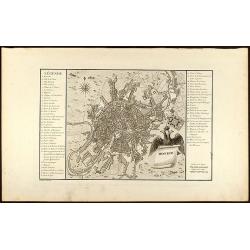
Moskou
Engraved map of Moscow with legend on left and right side. From the Atlas Volume of "Histoire physique, morale, civile et politique de la Russie Ancienne" by N....
Date: Paris, 1783
Selling price: ????
Please login to see price!
Sold in 2008
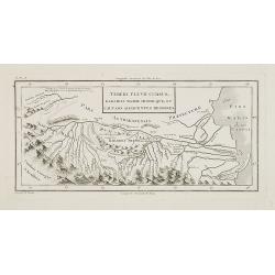
Tereki Fluvii Cursus, Kabarda major minor-que, et caucaso adjacentes regiones.
Map of Kabarda and the adjacent regions. The Kabardino-Balkaria Republic is located in the far southwestern Russian Federation, on the border with Georgia. To the right t...
Date: Paris, ca. 1783
Selling price: ????
Please login to see price!
Sold in 2009
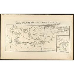
Carte de la Mer d\'Azof et d\'une Partie de la Mer Noire
Engraved map of the Crimean Peninsula with the Black Sea and the Sea of Azov in Russia. From the Atlas Volume of \"Histoire physique, morale, civile et politique de ...
Date: Paris, 1783
Selling price: ????
Please login to see price!
Sold in 2009
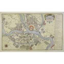
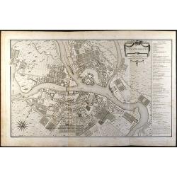
St. Petersbourg.
Large town-plan of St. Petersburg. From the Atlas Volume of "Histoire physique, morale, civile et politique de la Russie Ancienne" by N. G. Le Clerc. The plan i...
Date: Paris, 1783
Selling price: ????
Please login to see price!
Sold in 2009
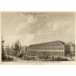
Vue de la Bourse et du Magazin des Marchandises en remontant la petite Neva
Beautiful view of the stock exchange and warehouse of St. Petersburg in Russia. From the Atlas Volume of "Histoire physique, morale, civile et politique de la Ru...
Date: Paris, 1783
Selling price: ????
Please login to see price!
Sold in 2009
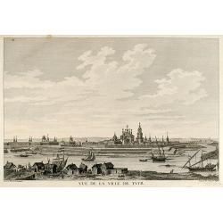
Vue de la Ville de Tver
Beautiful view of the city Twer between Moscow and St. Petersburg in Russia. From the Atlas Volume of "Histoire physique, morale, civile et politique de la Russi...
Date: Paris, 1783
Selling price: ????
Please login to see price!
Sold in 2009
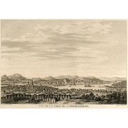
Vue de la Ville de Catherinebourg
Beautiful view of the city Yekaterinburg / Sverdlovsk in Russia. From the Atlas Volume of "Histoire physique, morale, civile et politique de la Russie Ancienne&a...
Date: Paris, 1783
Selling price: ????
Please login to see price!
Sold in 2009