Browse Listings in Europe
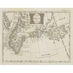
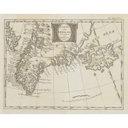
Karte von Groenland gezeichnet von Laurent 1770 . . . XX. Band N°1.
Map of Greenland and Iceland. In: Allgemeine Historie der Reisen zur Wasser und zu Lande: oder Sammlung aller Reisebeschreibungen.. in Englischen zusammen getragen, und a...
Date: Leipzig, 1753
Selling price: ????
Please login to see price!
Sold in 2008
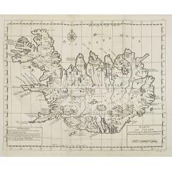
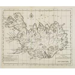
Karte von Island. . . N°1.
Map of Iceland. In: Allgemeine Historie der Reisen zur Wasser und zu Lande: oder Sammlung aller Reisebeschreibungen.. in Englischen zusammen getragen, und aus demselben u...
Date: Leipzig, 1753
Selling price: ????
Please login to see price!
Sold in 2008
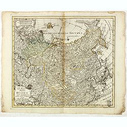
Karte von Sibirien. . . N°4.
Map of Siberia. In: Allgemeine Historie der Reisen zur Wasser und zu Lande: oder Sammlung aller Reisebeschreibungen.. in Englischen zusammen getragen, und aus demselben u...
Date: Leipzig, 1753
Selling price: ????
Please login to see price!
Sold in 2009
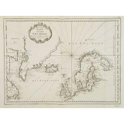
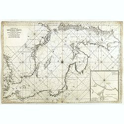
Karte von den Nord-Meeren zur allgemeinen Historie der Reisen
Map of the North sea with coastlines of Greenland, Iceland and Norway. In: Allgemeine Historie der Reisen zur Wasser und zu Lande: oder Sammlung aller Reisebeschreibungen...
Date: Leipzig, 1753
Selling price: ????
Please login to see price!
Sold in 2008
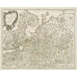
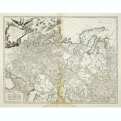
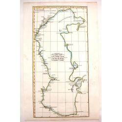
Partie Septentrionale de la Russie Européenne . . .
Map of the northern part of the Russian Empire, north of Moscow, including most of Finland.
Date: Paris, 1753
Selling price: ????
Please login to see price!
Sold in 2009
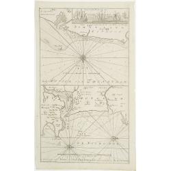
De Reede van 't Leith van Edenburgh. / Afteekening van Nieuw en Oud Aberdeene . . .
Latitude scale, compass rose and system of rhumb lines, soundings, anchorage's, etc. A wealth of cities and information appear in the chart. In upper right corner inset v...
Date: Amsterdam, 1753
Selling price: ????
Please login to see price!
Sold in 2011
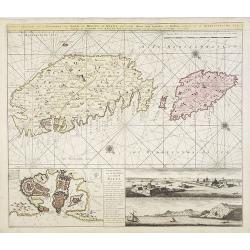
Nieuwe afteekening van de eylanden van Gozo en Melite of Malta met desselfs haven stad kasteelen en sterktens geleegen in de Middelandsche Zee. . .
A finely engraved and detailed chart of Malta and Gozo. With inset of Valetta and lettered key (148x293mm.) In the lower right two panoramic views "Gesigt van t inko...
Date: Amsterdam, 1753
Selling price: ????
Please login to see price!
Sold in 2009
Karte von Island. . . N°1.
Map of Iceland. In: Allgemeine Historie der Reisen zur Wasser und zu Lande: oder Sammlung aller Reisebeschreibungen.. in Englischen zusammen getragen, und aus demselben u...
Date: Leipzig, 1753
Selling price: ????
Please login to see price!
Sold in 2015
Karte von Groenland gezeichnet von Laurent 1770 . . . XX. Band N°1.
Map of Greenland and Iceland. In: Allgemeine Historie der Reisen zur Wasser und zu Lande: oder Sammlung aller Reisebeschreibungen.. in Englischen zusammen getragen, und a...
Date: Leipzig, 1753
Selling price: ????
Please login to see price!
Sold in 2010
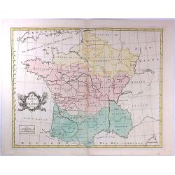
Gouvernemens Generaux du Poitou, du Pays d'Aunis, et de Saintonge-Angoumois
Map of the Poitoi-Charentes region of France, along the central western coast, showing the cities of Rochefort, Poitiers, Niort and Saintes. Ornamental cartouche is in lo...
Date: Paris: 1753
Selling price: ????
Please login to see price!
Sold in 2010
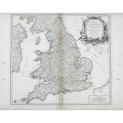
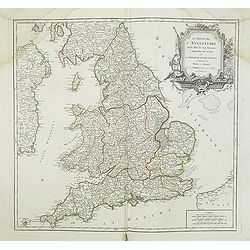
Le Royaume d'Angleterre, divise felon les sept Royaumes, ou Heptarchie des Saxons, avec La Principaute de Galles, et subdivise et Shires ou Comtes
Finely detailed, large scale map of England by Robert de Vaugondy. A large decorative title cartouche is at the top right corner.Gilles Robert de Vaugondy (1688-1766), al...
Date: Paris, 1753
Selling price: ????
Please login to see price!
Sold in 2010
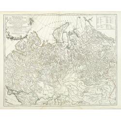
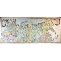
Carte Generale de L'Empire des Russes en Europe et en Asie dressée d'après les cartes de l'Atlas Russien. . .
Detailed map of Russia. extending from Poland and the Black Sea to Nova Zembla and the Jenisseniskoi region. Large decorative cartouche with six wind heads.
Date: Paris, 1753
Selling price: ????
Please login to see price!
Sold in 2011
Le Royaume D'Angleterre, divise selon les sept Royaumes ou Heptrachie des Saxons, avec La Principaute De Galles, et subdivisie en Shires ou Comtes...
Decorative map of British Isles with Rococo title cartouche, engraved by E.Haussard.
Date: Paris, 1753
Selling price: ????
Please login to see price!
Sold in 2014
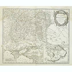
Partie méridionale de la Russie Européenne. . .
Detailed map of Ukraine and the Crimea. In lower right corner inset map of Cosaques. From his "Atlas Universel".Gilles Robert de Vaugondy (1688–1766), also kn...
Date: Paris, 1753
Selling price: ????
Please login to see price!
Sold in 2011
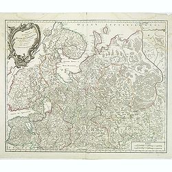
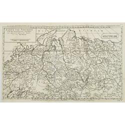
Partie Septentrionale de la Russie Européenne . . .
Detailed map of European part of Russia, including Finland, Lapland from his "Atlas Universel".Address and date in cartouche have been removed. Gilles Robert de...
Date: Paris, ca. 1753
Selling price: ????
Please login to see price!
Sold in 2011
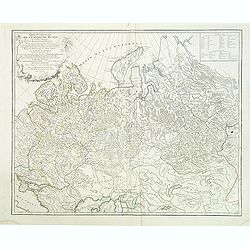
Partie Occidentale de l'Empire de Russie ou se trouve distinguée la Russie Européenne. . .
Detailed map of the European part of Russia from his "Atlas Universel".Gilles Robert de Vaugondy (1688–1766), also known as Le Sieur or Monsieur Robert, and h...
Date: Paris, 1753
Selling price: ????
Please login to see price!
Sold in 2011
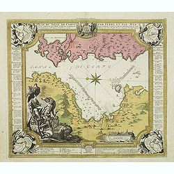
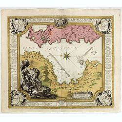
Plan du siege de Corfu par Terre et par Mer.
Uncommon map of the western coast of Corfu, including the town of Kérkira and its siege on July 5th, 1716. Upper part the coast of the Greek province of Sarande. Well-en...
Date: Nuremberg, 1753
Selling price: ????
Please login to see price!
Sold in 2013
Partie Occidentale de l'Empire de Russie ou se trouve distinguée la Russie Européenne. . .
Detailed map of the European part of Russia, prepared after Russian maps. The map has a rather long title, the first part reading "Partie occidentale de l'empire de ...
Date: Paris, 1753
Selling price: ????
Please login to see price!
Sold in 2016
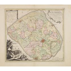
Kaart van het eiland Walcheren..
Detailed map prepared by D.W.Carel and A. Hattinga in 1751. Isaac Tirion was born in Utrecht ca. 1705. He came to Amsterdam ca. 1725. Tirion published a number of importa...
Date: Amsterdam, 1753
Selling price: ????
Please login to see price!
Sold in 2013
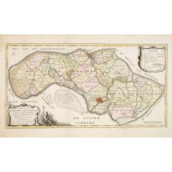
Kaarte van Schouwen en Duiveland. . .
Map of Schouwen Duiveland, prepared by D.W. Carel and Anth. Hattinga. Title cartouche accompanied by Neptune. Isaac Tirion was born in Utrecht ca. 1705. He came to Amster...
Date: Amsterdam, 1753
Selling price: ????
Please login to see price!
Sold in 2013
Environs de Paris
Detailed map of Paris and its surroundings with a decorative title cartouche and with cities, towns, forests. lakes, rivers & mountains clearly delineated. Gilles Rob...
Date: Paris, 1753
Selling price: ????
Please login to see price!
Sold in 2014
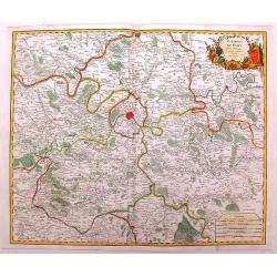
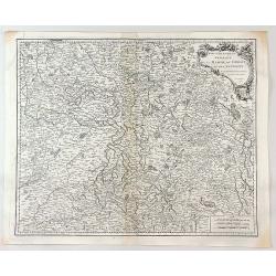
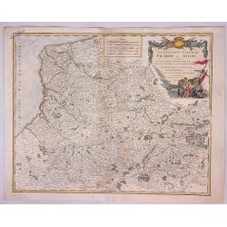
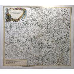
Carte des Cercles du Haut et du Bas Rhin.
Fine engraved hand-colored map of Rhineland Germany. With decorative title cartouche featuring a bishop's hat & miter and king's crown. The River Rhine flows through ...
Date: Paris, 1753
Selling price: ????
Please login to see price!
Sold in 2015
Tabula Geographica Circ. Saconiae Superioris et Inferioris.
Fine map featuring Poland and Saxony Germany. From the atlas "Atlas Geographicus Omnes Orbis Terrarum Regiones in XLI Tabulis".CARTOGRAPHER: Leonhard Euler (170...
Date: Berlin, 1753
Selling price: ????
Please login to see price!
Sold in 2015
Tab. Geogr. Circ. Franconiae dimid Saxoniae Superioris.
Fine map featuring part of Poland, Germany and the Czech Republic. From the atlas "Atlas Geographicus Omnes Orbis Terrarum Regiones in XLI Tabulis".CARTOGRAPHER...
Date: Berlin, 1753
Selling price: ????
Please login to see price!
Sold in 2015
Carte de la Mer Baltique contenant les bancs, isles et costes comprises entre l'isle de Zelande et l'extrémité du Golfe de Finlande.
Important chart of the Baltic Sea with the coasts of Sweden, Finland, Russia, Estonia, Lettland, Lithuania and Poland. With many place names along the coasts, anchor plac...
Date: Versailles, 1753
Selling price: ????
Please login to see price!
Sold in 2014
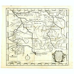
A map of some Provinces in Siberia, and the Borders toward China. . .
Detailed map of Siberia engraved by John Gibson for "The Gentleman's Magazine", founded by visionary Edward Cave, was the world's first monthly general interest...
Date: London, 1753
Selling price: ????
Please login to see price!
Sold in 2014
Plan du siege de Corfu par Terre et par Mer.
Uncommon map of the western coast of Corfu, including the town of Kérkira and its siege on July 5th, 1716. Upper part the coast of the Greek province of Sarande. Well-en...
Date: Nuremberg, 1753
Selling price: ????
Please login to see price!
Sold in 2021
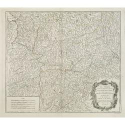
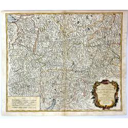
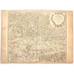
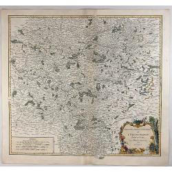
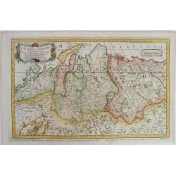
Le Tyrol sous le nom duquel. . .
De Vaugondy's large map of the mountainous Tirol region spanning portios of northern Italy, eastern Switzerland, and western Austria from his "Atlas Universel"....
Date: Paris 1753
Selling price: ????
Please login to see price!
Sold in 2016
Carte Generale de L'empire des Russes en Europe et en Asie, Dressee D'apres les Cartes de L'Atlas Russien, Par le S. Robert de Vaugondy ....
An extensive map of the Russian Empire by Vaugondy, dated 1753. It stretches across the full extent of Russia from Finland to Kamchatka.There is a stunning title cartouch...
Date: Paris, 1753
Selling price: ????
Please login to see price!
Sold in 2015
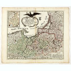
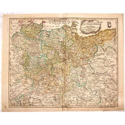
Tabula Geographica Borussiae ad emendatiora adhuc edita exempla iussu Acad. Regiae Scient. et eleg. Litt. Borussicae descripta.
Interesting map of Poland with a decorative title cartouche, and a Prussian duty stamp in the higher cartouche as usually for the Euler maps.Engraved by Nikolaus Friedric...
Date: Berlin, Michaelis, 1753
Selling price: ????
Please login to see price!
Sold in 2015
Tab: Georg : Imperu Russici...
A fine original antique map of Russia, China, Japan and Korea, with a decorative title cartouche, and a Prussian duty stamp at lower right as usually for the Euler maps.T...
Date: Berlin, 1753
Selling price: ????
Please login to see price!
Sold in 2016
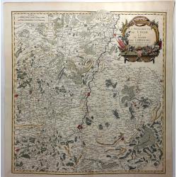
Le Tyrol Sous le Nom Duquel L'On Comprend le Comte de Tyrol
A scarce map of the county of Tyrol in modern day Italy and Austria, It covers this historic region from Lake Constance east to Lienz, Austria, and south as far as Lake G...
Date: Paris, 1753
Selling price: ????
Please login to see price!
Sold in 2016
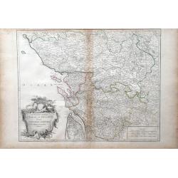
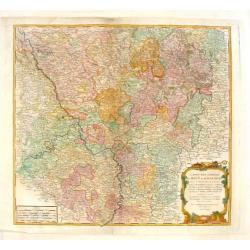
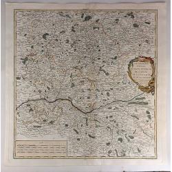
Gouvernemens Generaux de la Marche, du Limousin et de L'Auvergne.
A fine 1753 map of the Limousin, Marche and Auvergne regions of France by Robert de Vaugondy, dated 1753.It features from La Chatre south to Domme and from Perigueux east...
Date: Paris, 1753
Selling price: ????
Please login to see price!
Sold in 2017
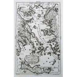
Neue Vorstellung der Insel Creta. . .
A rare map of the Aegean Sea and its islands. From Chalkidiki until Crete. With parts of the Greek and Turkish coats.After Anville, engraved by Reinhardt, published by th...
Date: Frankfurt & Leipzig, 1753
Selling price: ????
Please login to see price!
Sold in 2017
![Zuverlässige Nachrichten von Island [with] Landkarte von Island.](/uploads/cache/39895-250x250.jpg)
Zuverlässige Nachrichten von Island [with] Landkarte von Island.
>First German edition entitled "Zuverlässige Nachrichten von Island...", translation of Danish book from the previous year. Published in Copenhagen and Leip...
Date: Copenhagen and Leipzig, 1753
Selling price: ????
Please login to see price!
Sold in 2017
Carte des Cercles du Haut et du Bas Rhin...
An attractive detailed map of the Upper Rhine and Lower Rhine regions in western Germany. This area, known as Rhineland-Palatinate, it covers from Saarbrucken north to Pa...
Date: Paris, 1753
Selling price: ????
Please login to see price!
Sold in 2017
Gouvernment General de Picardie et Artois...
A beautiful de Vaugondy map of Picardy and Artois. The map covers part of the regions of Normandy (Normandie), l'Ile de France (Isle de France), and Champagne.The Pas de ...
Date: Paris, 1753
Selling price: ????
Please login to see price!
Sold in 2023
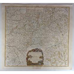
Gouvernemens Generaux du Maine et Perche de L'anjou, de la Touraine et du Saumurois.
This is a fine 1753 map of the French winemaking regions of Maine, Perche, Touraine, Anjou and Saumur. It depicts the whole or parts of the modern day departments of May...
Date: Paris, 1753
Selling price: ????
Please login to see price!
Sold in 2021
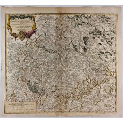
Partie Orientale du Gouvernement General de la Guenne.
An uncommon map of the Eastern Guyenne region of France, depicting the southern portion of France from Samatan east to Bruide and south as far as Toulouse, and covering t...
Date: Paris, 1753
Selling price: ????
Please login to see price!
Sold in 2019
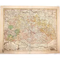
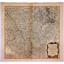
Partie Meridionale du Cercle de Haut Saxe. . .
This is a striking map of the historic provinces of le Duche de Saxe, le Marquisat de Minnie, & le Landgravlat de Thuringe, in France. The title is inside a richly de...
Date: Paris, 1753
Selling price: ????
Please login to see price!
Sold in 2018
Partie Septentrionale De La Russie Europeenne... Par Le Sr Robert De Vaugondy Géog Ordin du Roi Avec privilege 1753.
Very detailed and large map of North West part of Russia, from the Gulf of Finland and Poland to the western part of Russia. Map dated.
Date: 1753
Selling price: ????
Please login to see price!
Sold in 2017
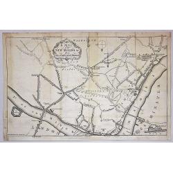
A Map of the New roads & c. from Westminster Bridge.
A detailed map of London, showing the road system south of the Thames River. The map is oriented with south at the top and extends from London Bridge, The Tower of London...
Date: London, 1753
Selling price: ????
Please login to see price!
Sold in 2019
Gouvernements Generaux du Berry, du Nivernois et du Bourbonois.
An antique hand colored map of the Berry, Nivers, Bourbon regions of France, including Bourges and Nevers in central France. Features a decorative cartouche with fruits a...
Date: Paris, 1753
Selling price: ????
Please login to see price!
Sold in 2018
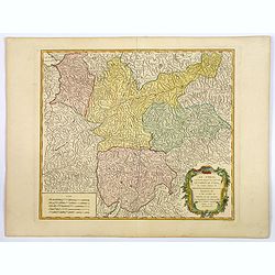
Le Tyrol sous le nom duquel. . .
Robert de Vaugondy's large map of the mountainous Tirol region spanning portions of northern Italy, eastern Switzerland, and western Austria from his "Atlas Universe...
Date: Paris, 1753
Selling price: ????
Please login to see price!
Sold in 2020
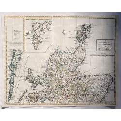
A New Map of the North Part of Scotland.
An antique map of the North Part of Scotland, drawn and engraved by Andrew Johnston, published in the third edition of William Camden's 'Britannia' in 1753. This map, and...
Date: Glasgow, 1753
Selling price: ????
Please login to see price!
Sold in 2023
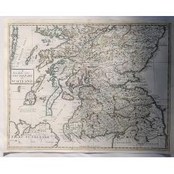
A New Map of the South Part of Scotland.
An antique map of the South Part of Scotland, drawn and engraved by Andrew Johnston, published in the third edition of William Camden's 'Britannia' in 1753. This map, and...
Date: Glasgow, 1753
Selling price: ????
Please login to see price!
Sold in 2023
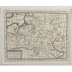
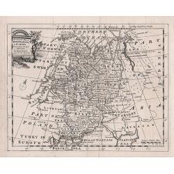
La Pologne.
An unusual 1752 Buffier copper engraved map of Poland. The map also covers Lithuania, part of Russia, Hungary, a portion of Ukraine, as well as a part of Romania. A decor...
Date: Paris, 1753
Selling price: ????
Please login to see price!
Sold in 2021
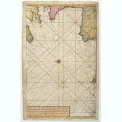
(Untitled sea chart of the North Sea with parts of the coasts of England, France, Ireland and Portugal.)
Center part of a larger sea chart of the North Sea with parts of the coasts of England, France, Ireland and Portugal. Scale in lower left.Sold as is.
Date: Amsterdam, 1753
Selling price: ????
Please login to see price!
Sold in 2021

Plan de la place de Corfu avec ses environs. . .
Uncommon map of the town of Kérkira and its siege in 1716, on the island of Corfu. Johann Baptist Homann's well-engraved map has a large decorative cartouche and in each...
Date: Nuremberg 1753
Selling price: ????
Please login to see price!
Sold in 2023
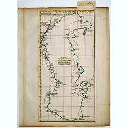
Essai D'Une Nouvelle Carte de la Mer Caspienne.
Simplistic map of the Caspian Sea.
Date: Paris, 1754
Selling price: ????
Please login to see price!
Sold in 2020
Essai D'Une Nouvelle Carte de la Mer Caspienne.
Interesting map of the Caspian Sea between Russia and Iran. Jean Baptiste d'Anville (1697-1782) born in Paris was perhaps the most important and prolific cartographer of ...
Date: Paris, 1754
Selling price: ????
Please login to see price!
Sold in 2013
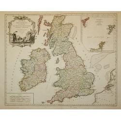
Les Isles Britanniques ...
Decorative map of British Isles with Rococo title cartouche and inset map with Shetland Islands.
Date: Paris, 1754
Selling price: ????
Please login to see price!
Sold in 2011
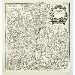
La principaute de Liege et le duche de Limbourg.
Detailled map of Belgium around Liege from his "Atlas Universel".Gilles Robert de Vaugondy (1688–1766), also known as Le Sieur or Monsieur Robert, and his son...
Date: Paris, 1754
Selling price: ????
Please login to see price!
Sold in 2013
An accurate map of Moscovy or Russia in Europe drawn from the best Authorities - by Emanuel Bowen
An attractive and highly detailed small map of Russia by Emanuel Bowen.
Date: London, 1754
Selling price: ????
Please login to see price!
Sold in 2012
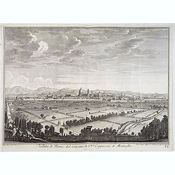
Veduta di Firenze dal Convento de P.P. Cappuccini di Montughi.
Distant view of the city of Florence in Tuscany region; seen from the north from the Capuchin convent at Montughi, after Giuseppe Zocchi (1711or 1717 - 1767) and engraved...
Date: Florence, Bouchard, 1754
Selling price: ????
Please login to see price!
Sold in 2016
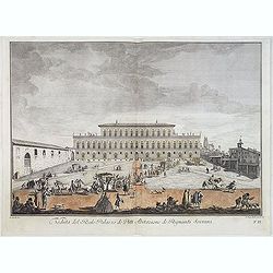
Veduta del Reale Palazzo dé Pitti Abitazione dé Regnanti Sovrani.
Lively view of a square with a Palace in Florence after Giuseppe Zocchi (1711or 1717 - 1767) and engraved by Johan Sebastian Muller of Nuremberg. From "Scelta di XXI...
Date: Florence, Bouchard, 1754
Selling price: ????
Please login to see price!
Sold in 2021
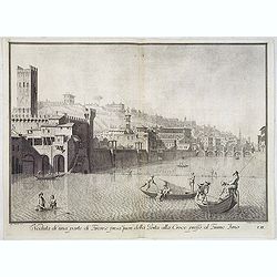
Veduta di una parte di Firenze presa fuori della Porta alla Croce presso al Fiume Arno.
Lively view of one of the entrance gates of Florence after Giuseppe Zocchi (1711or 1717 - 1767) and engraved by Carlo Gregori (1719-1759). From "Scelta di XXIV Vedut...
Date: Florence, Bouchard, 1754
Selling price: ????
Please login to see price!
Sold in 2014
Veduta di una parte di Firenze presa della Vaga Loggia.
Lively view of one of the entrance gates of Florence after Giuseppe Zocchi (1711or 1717 - 1767) and engraved by Antonio Pazzi. From "Scelta di XXIV Vedute delle prin...
Date: Florence, Bouchard, 1754
Selling price: ????
Please login to see price!
Sold in 2014
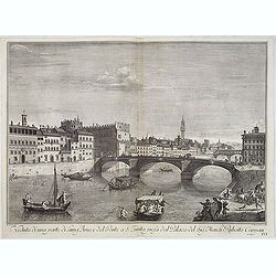
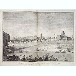
Veduta di una parte di Lung'Arno e del Ponte a S. Trinita presa dal Palazzo del Sig. March. Ruberto Capponi.
Lively view of St. Trinita bridge in Florence after Giuseppe Zocchi (1711or 1717 - 1767) and engraved by V.Francesschini. From "Scelta di XXIV Vedute delle principal...
Date: Florence, Bouchard, 1754
Selling price: ????
Please login to see price!
Sold in 2018
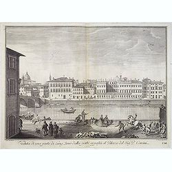
Veduta di una parte di Lung'Arno dalla parte opposta al Palazzo del Sig. P. Corsini.
Lively view of a canal in Florence after Giuseppe Zocchi (1711or 1717 - 1767) and engraved by Antonio Pazzi. From "Scelta di XXIV Vedute delle principali contrade, p...
Date: Florence, Bouchard, 1754
Selling price: ????
Please login to see price!
Sold in 2019
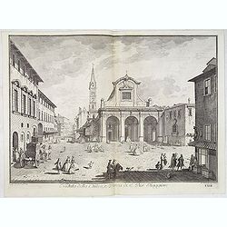
Veduta della Chiesa, e Piazza di S. Pier Maggiore.
Lively view of the Church and square San Pier Maggiore in Florence after Giuseppe Zocchi (1711or 1717 - 1767) and engraved by P. Monacus. From "Scelta di XXIV Vedute...
Date: Florence, Bouchard, 1754
Selling price: ????
Please login to see price!
Sold in 2018

Hoxton Hospitall.
A fine 18th century copper engraving by Johannes Kip, featuring a view of Hoxton Hospital or Aske's Hospital on Pitfield Street in London. It was published according to A...
Date: London, 1754
Selling price: ????
Please login to see price!
Sold in 2015

An exact Survey of the Cities of London and Westminster, the Borough of Southwark, The Country near ten Miles round begun in 1741, finished in 1745, and publish'd in 1746. . .
Key wall-map of the greater London area surveyed by John Rocque and published in 16 sheets. One of the finest maps of – what is now – Greater London ever produced. Ac...
Date: London, 1751/1754
Selling price: ????
Please login to see price!
Sold in 2014
Poland Lithuania and Prussia.
Nice example of Bowen's map of Poland and Lithuania.
Date: London, 1752-1754
Selling price: ????
Please login to see price!
Sold in 2015
Comtes de Hainaut et de Cambresis.
Large copperplate map of parts of Belgium and France including the counties of Hainaut, Cambrai, Flanders, Brabant and Namur. It was published by Robert de Vaugondy.
Date: Paris, 1754
Selling price: ????
Please login to see price!
Sold in 2016
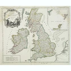
Les Isles Britanniques. . .
Decorative map of British Isles with Rococo title cartouche and inset map with Shetland Islands.
Date: Paris, 1754
Selling price: ????
Please login to see price!
Sold in 2015
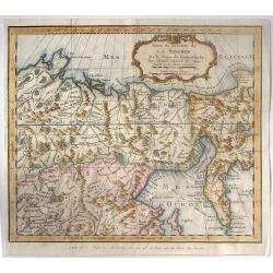
Suite de la Carte de la Siberie et le Pays de Kamtschatka pour l'Histoire Generale des Voyages.
A striking map of eastern Siberia above and below the Arctic Circle, showing the Sea of Okhotsk, the Kamtschatka Peninsula, and Sakhalin Island. The map is from Bellin�...
Date: Paris, 1754
Selling price: ????
Please login to see price!
Sold in 2016
2e. Carte de France
A pleasant minimalistic map of France, featuring the French provinces and the capital of each, but with very little detail. It was engraved by Thomas Kitchin, and is date...
Date: London, 1754
Selling price: ????
Please login to see price!
Sold in 2016
Essai d'une Nouvelle Carte de la Mer Caspienne.
Useful map of the Caspian Sea by the French cartographer d'Anville.
Date: Paris, ca. 1754
Selling price: ????
Please login to see price!
Sold in 2016
Gouvernement General de L'Isle de France Divise par Pays.
Showing the region around Paris, France, with hand colored outlines and decorated cartouche, by Vaugondy, in 1754. Written in French. Map is detailed and includes illustr...
Date: Paris, 1754
Selling price: ????
Please login to see price!
Sold in 2018
La Principaute de Liege et le Duche de Limbourg.
A scarce 1754 map of Liege and Limbourg, Belgium by Robert de Vaugondy. It covers parts of northeastern Belgium and southern Netherlands along with neighbouring Germany.O...
Date: Paris , 1754
Selling price: ????
Please login to see price!
Sold in 2019
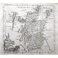
Scotland.
A small and detailed copper engraved map of Scotland. Names many towns, rivers, loughs, and even small islands like North Rona, St. Kilda, etc...Decorated with a title ca...
Date: London, ca 1754
Selling price: ????
Please login to see price!
Sold in 2018
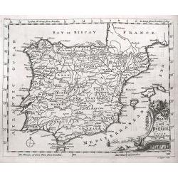
Spain and Portugal.
A small interesting copper engraved map of the Iberian peninsula. It names many towns, rivers, and includes the Balearic Islands. Extends to show also Tanger and Ceuta.De...
Date: London, ca 1754
Selling price: ????
Please login to see price!
Sold in 2018
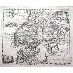
Sweden, Denmark, Norway and Finland.
A small but detailed copper engraved map of Scandinavia, including the Baltic. A small inset map shows Spitsbergen (here named East Greenland) and the North Cape. Names m...
Date: London, ca 1754
Selling price: ????
Please login to see price!
Sold in 2020
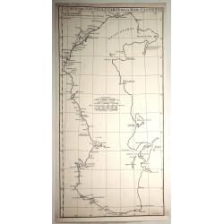
Carte De La Siberie Et des Pays voisins pour servir a l'Histoire general des Voyages . . .
Large detailed copper engraved map centering on Siberia, from Nouvelle Zemle and the Arctic Circle, down to Mer Caspiene (Caspian Sea) and Mer d'Aral. The map with captio...
Date: Paris, 1754
Selling price: ????
Please login to see price!
Sold in 2019
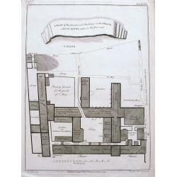
A plan of the ground and buildings in the Strand called the Savoy, taken in the year 1736.
A rare detailed plan of the Savoy between the Strand and the Thames in London. With details of each building and the business operating there. A scale bar shows distance ...
Date: London, ca 1754
Selling price: ????
Please login to see price!
Sold in 2020
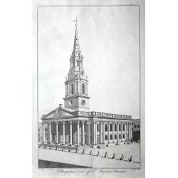
A set of 10 views of London Church's engraved by Benjamin Cole.
10 Original antique copper engravings For William Maitlands "History of London" Published in London, 1755. Titles: A PERSPECTIVE VIEW OF ST. MARTINS CHURCH....
Date: London, 1755
Selling price: ????
Please login to see price!
Sold in 2016
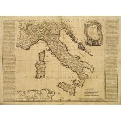
L'Italie Divisée en tous ses Estats..
RARE map of Italy prepared by J.B.Nolin and published by Daumont. A visually stunning map with a large title cartouche.To the left and right text boxes with a geographica...
Date: Paris 1755
Selling price: ????
Please login to see price!
Sold
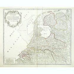
Provinces-Unies des Pays-Bas, . . .
Detailed map of the Netherlands, identifying the various provinces, with a large decorative cartouche. From his "Atlas Universel".Gilles Robert de Vaugondy (168...
Date: Paris, 1755
Selling price: ????
Please login to see price!
Sold in 2011
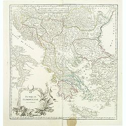
Turquie Européenne.
A beautiful map of Greece, with the coast of Turkey from De Vaugondy’s 1752 Atlas Universal. Depicts the whole of Greece from Bosnia and Croatia east to through Bulgari...
Date: Paris, 1755
Selling price: ????
Please login to see price!
Sold in 2011