Browse Listings in Europe
![[3 Maps] Latium, Italia propria, Magna Graecia Italiae antiquae pars.](/uploads/cache/92133-250x250.jpg)
[3 Maps] Latium, Italia propria, Magna Graecia Italiae antiquae pars.
Map 1 Latium Roma and its environs. Good condition strong impression, Map 2 Italia propria condition one small margin tear top left strong impression, Map 3 Magna Graec...
Date: Leipzig, 1755
Selling price: ????
Please login to see price!
Sold in 2013
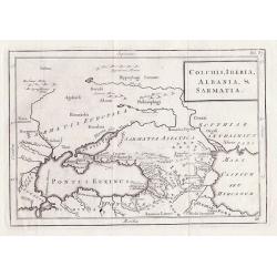
Colchis, Iberia, Albania & Sarmatia.
Outline map shows the Black Sea, Ukraine, Turkey, parts of Russia and adjacent areas, Christoph Cellarius, 17955 for "Geographia Antiqua".
Date: Leipzig, 1755
Selling price: ????
Please login to see price!
Sold in 2012
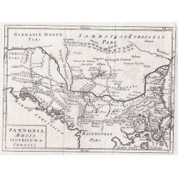
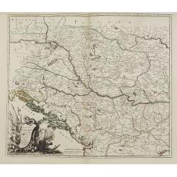
Pannonia Moesia Illyricum & Thracia.
Pannonia Moesia Illyricum & Thracia by Christoph Cellarius c1755 from his Geographia Antiqua. Highly detailed map of ancient Greece.
Date: Leipzig, 1755
Selling price: ????
Please login to see price!
Sold in 2014
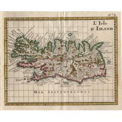
L Isle D\'Island
Small map of Iceland from Discours sur L'Histoire Universelle…
Date: Amsterdam 1755
Selling price: ????
Please login to see price!
Sold in 2014
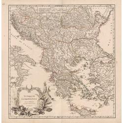
Turquie Européenne.
A beautiful map of Greece, with the coast of Turkey from De Vaugondy’s 1752 Atlas Universal. Depicts the whole of Greece from Bosnia and Croatia east to through Bulgari...
Date: Paris, 1755
Selling price: ????
Please login to see price!
Sold in 2013
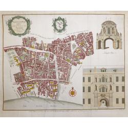
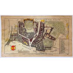
Farringdon ward without with it's division into parishes according to a new survey.
This plan was published in William Maitland's "History of London from its Foundation to the Present Time." The plan's title features in a cartouche at the top l...
Date: London, 1755
Selling price: ????
Please login to see price!
Sold in 2015
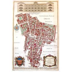
Cripplegate Ward with its Division into Parishes According to a New Survey.
A fine decorative, detailed plan of a section of London, England from John Stow's "A SURVEY OF THE CITIES OF LONDON & WESTMINSTER" published in London in 17...
Date: London, 1755
Selling price: ????
Please login to see price!
Sold in 2018
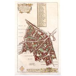
Aldgate Ward with its Division into Parishes Taken from the Latest Survey.
A fine decorative, detailed plan of a section of London, England from John Stow's "A SURVEY OF THE CITIES OF LONDON & WESTMINSTER" published in London in 17...
Date: London, 1755
Selling price: ????
Please login to see price!
Sold in 2019
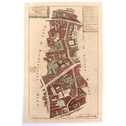
A Mapp of Lime Street Ward, Taken from ye Last Surveys & Corrected.
An eighteenth-century plan of Lime Street Ward in the heart of the City of London. The area covered extends north from Fenchurch Street across Leadenhall Street and via S...
Date: London, 1755
Selling price: ????
Please login to see price!
Sold in 2019
The Prospect of Lincoln's Inn.
A pleasing picture of 'The Prospect of Lincoln's Inn' included in 'Stow's Survey of London', a fine copper engraving published in 1755. It is an fine example of the Engli...
Date: London, 1755
Selling price: ????
Please login to see price!
Sold in 2018
Normannia Galliae Celebris Provincia
A detailed map of the Normandy coast based on the cartography of Delisle. On the left side is a glimpse of the Atlantic Ocean. In the lower right is Chartres. In the uppe...
Date: Nuremberg, 1755
Selling price: ????
Please login to see price!
Sold in 2017
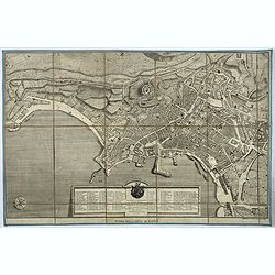
Pianta della citta' di Napoli.
Very rare town-plan of Naples, designed and engraved by the French architect Maurice-Louis Jolivet, and published in Naples by Gravier. It is accompanied by numbered key ...
Date: Naples, ca. 1755
Selling price: ????
Please login to see price!
Sold in 2017
Cow Cross, Being St. Sepulcher's Parish with the Charter House.
A lovely detailed copper engraved city plan of Saint Sepulcher's parish featuring the Charter House. The key at the right lists 29 featured locations within the parish. ...
Date: London, 1755
Selling price: ????
Please login to see price!
Sold in 2018
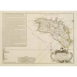
2e. Carte D'Italie 1755.
A curious map of Italy by Thomas Kitchin. Only a few major cities and rivers are named. Also the Vesuv and Etna volcanoes are shown. With a large decorative title cartouc...
Date: London, 1755
Selling price: ????
Please login to see price!
Sold in 2020
-250x250.JPG)
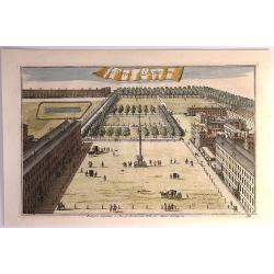
Gezigt van den Tuin van Somerset's Paleis, Langs den Theems tot op de Brug van Londen
Very nice 18th century copper engraved view of London from the bank of the Thames, with St. Paul´s Cathedral central on the image and showing many interesting details. T...
Date: 1755
Selling price: ????
Please login to see price!
Sold in 2023

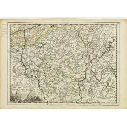
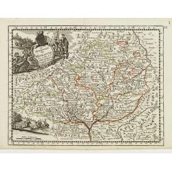
La Saxe Contenant le Routes et les postes. . .
Fine post-route map of Saxony in Germany with a splendidly engraved title cartouche. The map is centered on Leipzig. George Louis Le Rouge was active between 1740 and 178...
Date: Paris, 1756
Selling price: ????
Please login to see price!
Sold in 2025
![Plan Du Port De Lisbonne Et Des Costes Voisines.. [Lisbon]](/uploads/cache/23031-250x250.jpg)
Plan Du Port De Lisbonne Et Des Costes Voisines.. [Lisbon]
A well engraved and highly detailed chart of Lisbon harbour with a decorative horizontal panorama along upper part. It shows soundings, anchorage's, channels, shoals, nav...
Date: Paris, 1756
Selling price: ????
Please login to see price!
Sold
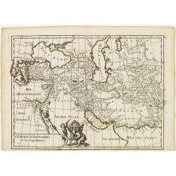
L'Empire d'Alexandre et ses Expeditions.
Fine map showing the territory conquered by Alexander the Great. With decorative cartouche on lower part, left to center fold. George Louis Le Rouge was active from 1740-...
Date: Paris, 1756
Selling price: ????
Please login to see price!
Sold in 2015
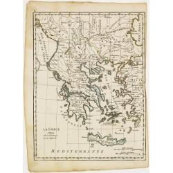
La Grece.
Fine map of Greece. George Louis Le Rouge was active from 1740- till 1780 as a publisher, and was appointed engineer for the King of France. From his Atlas Nouveau Portat...
Date: Paris 1756
Selling price: ????
Please login to see price!
Sold
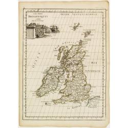
Les Isles du Britanniques.
Fine map of the British Isles with a fine cartouche depicting vessels approaching the harbour.George Louis Le Rouge was active from 1740- till 1780 as a publisher, and wa...
Date: Paris 1756
Selling price: ????
Please login to see price!
Sold
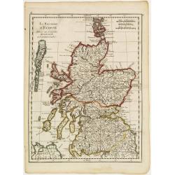
Le Royaume d'Ecosse..
Fine map of Scotland. George Louis Le Rouge was active from 1740- till 1780 as a publisher, and was appointed engineer for the King of France. From his Atlas Nouveau Port...
Date: Paris 1756
Selling price: ????
Please login to see price!
Sold
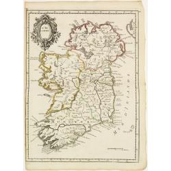
L'Irlande.
Fine map of Ireland with a decorative title cartouche. George Louis Le Rouge was active from 1740- till 1780 as a publisher, and was appointed engineer for the King of Fr...
Date: Paris 1756
Selling price: ????
Please login to see price!
Sold
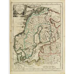
La Scandinavie ounla Suede et Danmark.
Fine map of Scandinavia with a decorative title cartouche. George Louis Le Rouge was active from 1740- till 1780 as a publisher, and was appointed engineer for the King o...
Date: Paris 1756
Selling price: ????
Please login to see price!
Sold
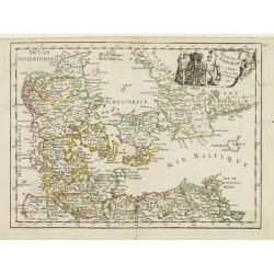
Royaume de Danemarck.
Fine map of Denmark with a decorative title cartouche. George Louis Le Rouge was active from 1740- till 1780 as a publisher, and was appointed engineer for the King of Fr...
Date: Paris 1756
Selling price: ????
Please login to see price!
Sold
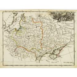
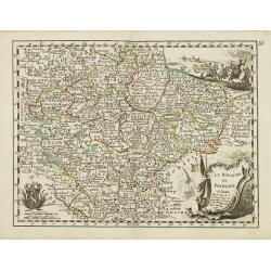
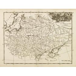
La Pologne.
Fine map of Poland. George Louis Le Rouge was active from 1740- till 1780 as a publisher, and was appointed engineer for the King of France. From his Atlas Nouveau Portat...
Date: Paris 1756
Selling price: ????
Please login to see price!
Sold
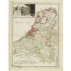
Les XVII Provinces des Pays Bas.
Fine map of the Netherlands with a decorative title cartouche. George Louis Le Rouge was active from 1740- till 1780 as a publisher, and was appointed engineer for the Ki...
Date: Paris 1756
Selling price: ????
Please login to see price!
Sold
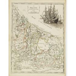
La Hollande ou les Provinces Reunies.
Fine map of Holland including Zeeland, Brabant, Utrecht, Overijssel, Friesland and Groningen. It presents a decorative cartouche on upper right corner depicting two large...
Date: Paris 1756
Selling price: ????
Please login to see price!
Sold
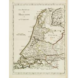
Les Provinces de Hollande et d'Utrecht.
Fine map of Holland and Utrecht. George Louis Le Rouge was active from 1740- till 1780 as a publisher, and was appointed engineer for the King of France. From his Atlas N...
Date: Paris 1756
Selling price: ????
Please login to see price!
Sold
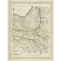
Duché de Gueldres.
Fine map of Gelderland. George Louis Le Rouge was active from 1740- till 1780 as a publisher, and was appointed engineer for the King of France. From his Atlas Nouveau Po...
Date: Paris 1756
Selling price: ????
Please login to see price!
Sold
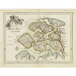
Zelande.
Fine map of Zeeland with a decorative title cartouche. George Louis Le Rouge was active from 1740- till 1780 as a publisher, and was appointed engineer for the King of Fr...
Date: Paris 1756
Selling price: ????
Please login to see price!
Sold
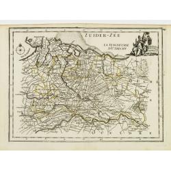
La Seigneurie d'Utrecht.
Fine map of Utrecht presenting a decorative cartouche on upper right corner. George Louis Le Rouge was active from 1740- till 1780 as a publisher, and was appointed engin...
Date: Paris 1756
Selling price: ????
Please login to see price!
Sold
La Flandre Le Haynaut.
Fine map of the Flanders and the province of Hainaut. It presents a decorative title cartouche and a decorative cartouche on upper left corner. George Louis Le Rouge was ...
Date: Paris 1756
Selling price: ????
Please login to see price!
Sold
Duché de Luxembourg.
Fine map of Luxembourg with a decorative title cartouche. George Louis Le Rouge was active from 1740- till 1780 as a publisher, and was appointed engineer for the King of...
Date: Paris 1756
Selling price: ????
Please login to see price!
Sold
La France Divisée En ses 37 Gouvernements Militaires.
Fine map of France with decorative title cartouche. George Louis Le Rouge was active from 1740- till 1780 as a publisher, and was appointed engineer for the King of Franc...
Date: Paris 1756
Selling price: ????
Please login to see price!
Sold
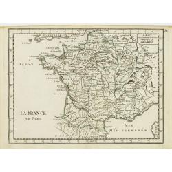
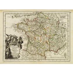
La France par Postes.
Fine map of France. George Louis Le Rouge was active from 1740- till 1780 as a publisher, and was appointed engineer for the King of France. From his Atlas Nouveau Portat...
Date: Paris 1756
Selling price: ????
Please login to see price!
Sold
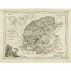
La Frise.
Fine map of Friesland with a decorative cartouche on lower left corner. George Louis Le Rouge was active from 1740- till 1780 as a publisher, and was appointed engineer f...
Date: Paris 1756
Selling price: ????
Please login to see price!
Sold
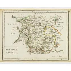
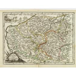
Seigneurie d'Over-Yssel.
Fine map of Overijssel. George Louis Le Rouge was active from 1740- till 1780 as a publisher, and was appointed engineer for the King of France. From his Atlas Nouveau Po...
Date: Paris 1756
Selling price: ????
Please login to see price!
Sold
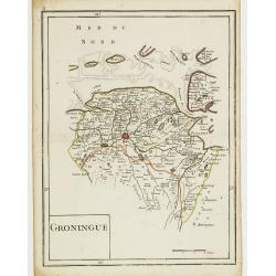
Groningue.
Fine map of Groningen. George Louis Le Rouge was active from 1740- till 1780 as a publisher, and was appointed engineer for the King of France. From his Atlas Nouveau Por...
Date: Paris 1756
Selling price: ????
Please login to see price!
Sold
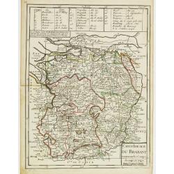
Carte Idéale du Brabant contenant les Camps de 1746 et 1747.
Fine map of Brabant. George Louis Le Rouge was active from 1740- till 1780 as a publisher, and was appointed engineer for the King of France. From his Atlas Nouveau Porta...
Date: Paris 1756
Selling price: ????
Please login to see price!
Sold
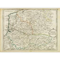
Artois Picardie.
Fine map of the French provinces of Picardy and Artois. George Louis Le Rouge was active from 1740- till 1780 as a publisher, and was appointed engineer for the King of F...
Date: Paris 1756
Selling price: ????
Please login to see price!
Sold
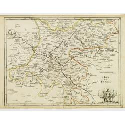
L'Isle de France.
Fine map of the French region Île de France whose chief town is Paris. It presents a decorative cartouche on lower right corner. George Louis Le Rouge was active from 17...
Date: Paris 1756
Selling price: ????
Please login to see price!
Sold
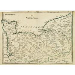
La Normandie.
Fine map of the French region Normandy. George Louis Le Rouge was active from 1740- till 1780 as a publisher, and was appointed engineer for the King of France. From his ...
Date: Paris 1756
Selling price: ????
Please login to see price!
Sold
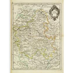
La Champagne.
Fine map of the French region Champagne, with decorative title cartouche. George Louis Le Rouge was active from 1740- till 1780 as a publisher, and was appointed engineer...
Date: Paris 1756
Selling price: ????
Please login to see price!
Sold
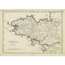
La Bretagne.
Fine map of the French region Brittany. George Louis Le Rouge was active from 1740- till 1780 as a publisher, and was appointed engineer for the King of France. From his ...
Date: Paris 1756
Selling price: ????
Please login to see price!
Sold
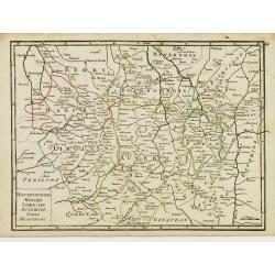
Orleanois, Perche, le Mans, Anjou, Tourraine, Berry.
Fine map of today's French region called Centre, including the towns of Orleans, Tours and Bourges. With decorative title cartouche. George Louis Le Rouge was active from...
Date: Paris 1756
Selling price: ????
Please login to see price!
Sold
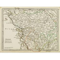
Poitou, Saintonge, Angoumois.
Fine map of the today's French region Poitou-Charente, including part of the Vendée. George Louis Le Rouge was active from 1740- till 1780 as a publisher, and was appoin...
Date: Paris 1756
Selling price: ????
Please login to see price!
Sold
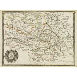
Bourbonnois, Marche, Limousin, Auvergne, Forez, Beaujolois.
Fine map of the today's French regions of Limousin and Auvergne, including part of the Rhône-Alpes region. George Louis Le Rouge was active from 1740- till 1780 as a pub...
Date: Paris 1756
Selling price: ????
Please login to see price!
Sold in 2010
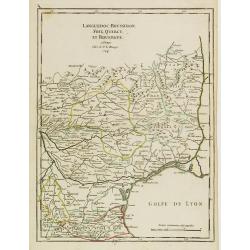
Languedoc, Roussillon, Foix, Quercy, et Rouergue.
Fine map of the French region Languedoc-Roussillon, including some territory at its East. George Louis Le Rouge was active from 1740- till 1780 as a publisher, and was ap...
Date: Paris 1756
Selling price: ????
Please login to see price!
Sold
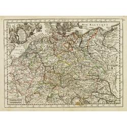
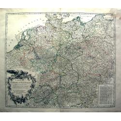
L'Empire d'Allemagne..
Fine map of Germany, with decorative title cartouche. George Louis Le Rouge was active from 1740- till 1780 as a publisher, and was appointed engineer for the King of Fra...
Date: Paris 1756
Selling price: ????
Please login to see price!
Sold
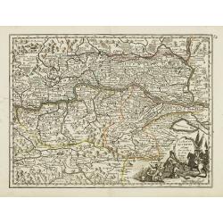
Le Cercle d'Autriche.
Fine map of Austria. It presents a decorative title cartouche and a cartouche depicting knights whose impression is slightly faded. George Louis Le Rouge was active from ...
Date: Paris 1756
Selling price: ????
Please login to see price!
Sold
La Haute Autriche..
Fine map of the western part of Austria with a decorative title cartouche. George Louis Le Rouge was active from 1740- till 1780 as a publisher, and was appointed enginee...
Date: Paris 1756
Selling price: ????
Please login to see price!
Sold
La Basse Autriche.
Fine map of the eastern part of Austria with a decorative title cartouche. George Louis Le Rouge was active from 1740- till 1780 as a publisher, and was appointed enginee...
Date: Paris 1756
Selling price: ????
Please login to see price!
Sold
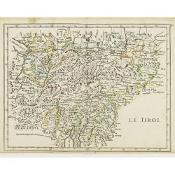
Le Tirol.
Fine map of Tyrol. In lower part Lake Garda and in upper right the skiing grounds of Innsbruck, Kuffstein, etc.George Louis Le Rouge was active from 1740- till 1780 as a ...
Date: Paris 1756
Selling price: ????
Please login to see price!
Sold
Le Royaume de Boheme.
Fine map of Bohemia, with title cartouche and two decorative cartouches on upper right and lower left corners. George Louis Le Rouge was active from 1740- till 1780 as a ...
Date: Paris 1756
Selling price: ????
Please login to see price!
Sold
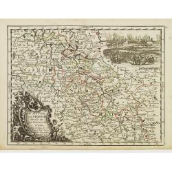
Le Duché de Silesie..
Fine map of Silesia. With title cartouche and decorative cartouche on upper right corner. George Louis Le Rouge was active from 1740- till 1780 as a publisher, and was ap...
Date: Paris 1756
Selling price: ????
Please login to see price!
Sold
Le Royaume de Hongrie.
Fine map of Hungary, with title cartouche. With title cartouche and decorative cartouche on upper right corner. George Louis Le Rouge was active from 1740- till 1780 as a...
Date: Paris 1756
Selling price: ????
Please login to see price!
Sold
Le Marquisat de Moravie.
Fine map of Moravia, with decorative title cartouche and another cartouche on lower left corner. George Louis Le Rouge was active from 1740- till 1780 as a publisher, and...
Date: Paris 1756
Selling price: ????
Please login to see price!
Sold
La Baviere..
Fine map of Bavaria, with decorative title cartouche. George Louis Le Rouge was active from 1740- till 1780 as a publisher, and was appointed engineer for the King of Fra...
Date: Paris 1756
Selling price: ????
Please login to see price!
Sold
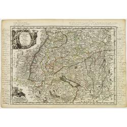
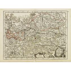
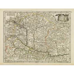
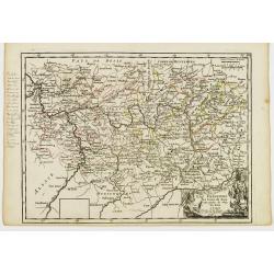
La Souabe.
Fine map of Schwaben, with decorative title cartouche and another cartouche in lower left corner. With manuscript notes in top, left and right margins giving some histori...
Date: Paris 1756
Selling price: ????
Please login to see price!
Sold in 2021
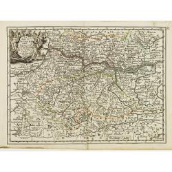
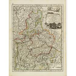
Cercle de la Haute Saxe.
Fine map of Saxony, with decorative title cartouche. George Louis Le Rouge was active from 1740- till 1780 as a publisher, and was appointed engineer for the King of Fran...
Date: Paris 1756
Selling price: ????
Please login to see price!
Sold in 2018
L'Electorat de Cologne, Le Duché de Bergue et Juliers.
Fine map of the south-eastern part of North Rhine-Westphalia, around Düsseldorf and Cologne. With decorative title cartouche. George Louis Le Rouge was active from 1740 ...
Date: Paris 1756
Selling price: ????
Please login to see price!
Sold in 2020
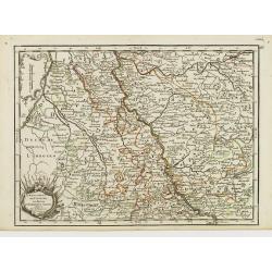
La Franconie.
Fine map of the German region Baden-Württemberg, with decorative title cartouche. With manuscript notes in left margin giving some historical information about the regio...
Date: Paris 1756
Selling price: ????
Please login to see price!
Sold in 2020
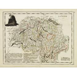
La Suisse.
Fine map of Switzerland with dark decorative cartouche on upper left corner. With date 1743 added in manuscript.George Louis Le Rouge was active from 1740- till 1780 as a...
Date: Paris 1756
Selling price: ????
Please login to see price!
Sold in 2009
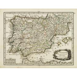
L' Espagne Suivant les Nouvelles Observations.
Fine map of Spain and Portugal with decorative title cartouche. With date 1743 added in manuscript.George Louis Le Rouge was active from 1740- till 1780 as a publisher, a...
Date: Paris 1756
Selling price: ????
Please login to see price!
Sold
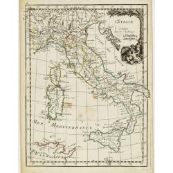
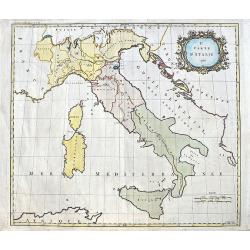
L' Italie.
Fine map of Italy with decorative title cartouche. With date 1743 added in manuscript.George Louis Le Rouge was active from 1740- till 1780 as a publisher, and was appoin...
Date: Paris, 1756
Selling price: ????
Please login to see price!
Sold in 2020
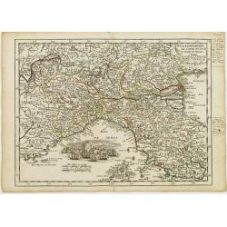
La Lombardie, Le Cours du Po &c Le Duché de Toscane.
Fine map of northern Italy with decorative cartouche illustrating some vessels in the gulf of Genoa. With manuscript notes in right margin giving some historical informat...
Date: Paris 1756
Selling price: ????
Please login to see price!
Sold
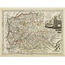
La Savoye.
Fine map of Savoy with decorative cartouches on right corners. George Louis Le Rouge was active from 1740- till 1780 as a publisher, and was appointed engineer for the Ki...
Date: Paris 1756
Selling price: ????
Please login to see price!
Sold
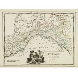
République de Gênes.
Fine map of the gulf of Genoa. With decorative title cartouche. With date 1749 added in manuscript.George Louis Le Rouge was active from 1740- till 1780 as a publisher, a...
Date: Paris 1756
Selling price: ????
Please login to see price!
Sold
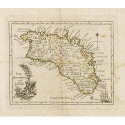
Carte topographique DE L'ISLE MINORQUE, Dédiée et présentée au Roy ..
Very rare map depicting the island of Minorca. The bottom is decorated with a stunning title cartouche, engraved by Choffard.The French text on the left side contains a l...
Date: Paris 1756
Selling price: ????
Please login to see price!
Sold
Veduta della Citta di Siviglia../ ..Eglise de Seville.
Fine panoramic view of the Sevillia. Taken from Storia moderna di tutti I popoli del mondo , edited by Thomas Salmon. A italian edition of this famous work, published in ...
Date: Venice 1740-1756
Selling price: ????
Please login to see price!
Sold
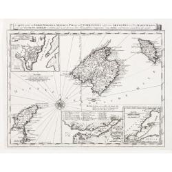
Carte welche die Inseln Maiorca, Minorca, Yvica und Formentera..
So called "Einblattdruck" of Majorca, Minorca and 2 insets of parts of the Island Majorca. Prepared after Felßecker and Bellin.
Date: Frankfurt a.Main & Leipzig, dated 1756
Selling price: ????
Please login to see price!
Sold
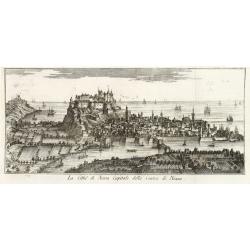
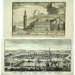
La Citta di Nizza Capitale della Contea di Nizza.
Fine panoramic views of Nice, taken from Storia moderna di tutti I popoli del mondo , edited by Thomas Salmon. A Italian edition of this famous work, published in 26 volu...
Date: Venice, 1740-1756
Selling price: ????
Please login to see price!
Sold in 2011
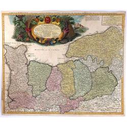
Le Royaume de Hongrie la Transilvanie L'Esclavonie la Croatie et la Bosnie.
Fine map of Hungary with a splendid cartouche of an elephant, a crocodile and a canon and canon balls in the forefront and an array of flags amidst a cloud of smoke in th...
Date: Paris, 1756
Selling price: ????
Please login to see price!
Sold in 2013
La Pologne.
Fine map of Poland. George Louis Le Rouge was active from 1740- till 1780 as a publisher, and was appointed engineer for the King of France.From his Atlas Nouveau Portati...
Date: Paris, 1756
Selling price: ????
Please login to see price!
Sold in 2008
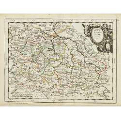
Carte de L'Empire D'Allemagne divisé en ses dix cercles,...
Detailed engraved map of all of Germany, extending to Northern Italy, Poland, Austria, Switzerland, the Benelux, and France. Filled with topographical information: Cit...
Date: Paris, 1756
Selling price: ????
Please login to see price!
Sold in 2011
Isle Minorque.
Nice map of the island of Majorca, title cartouche lower left. Orientated to the north.
Date: Paris, 1756
Selling price: ????
Please login to see price!
Sold
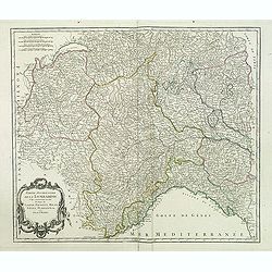
Partie occidentale de la Lombardie. . .
Detailed map of the region of the north of Italy from his "Atlas Universel." Gilles Robert de Vaugondy (1688–1766), also known as Le Sieur or Monsieur Robert,...
Date: Paris, 1756
Selling price: ????
Please login to see price!
Sold in 2011
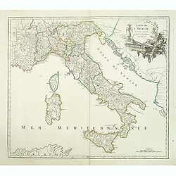
Carte de l'Italie dans laquelle sont tracées les routes des postes.
post road maps map of Italy, including the island of Corsica, Sardine and Sicilia from his "Atlas Universel".Gilles Robert de Vaugondy (1688–1766), also known...
Date: Paris, 1756
Selling price: ????
Please login to see price!
Sold in 2014
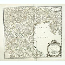
Partie occidentale de la Lombardie qui comprend la République de Venise. . .
Detailed map of region of north of Italia from his "Atlas Universel".Gilles Robert de Vaugondy (1688–1766), also known as Le Sieur or Monsieur Robert, and his...
Date: Paris, 1756
Selling price: ????
Please login to see price!
Sold in 2011
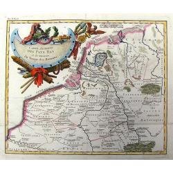
Carte Ancienne des Pays Bas et des Environs du Temps des Romains.
Copper engraved map of The Netherlands in the time of the domination by the Roman Empire. The map also includes portions of Belgium and Germany. The Renaissance title car...
Date: Paris, 1756
Selling price: ????
Please login to see price!
Sold in 2013