Browse Listings in Europe
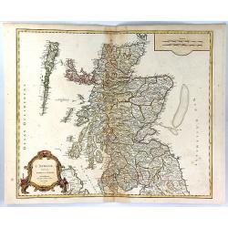
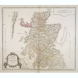
L'Ecosse Divisee en Shires ou Comtes
A decorative map of Scotland, published by Boudet in Paris in 1751. The map includes a decorative Rococo cartouche and scale of miles in the bottom left corner.The map is...
Date: Paris, 1751
Selling price: ????
Please login to see price!
Sold in 2023
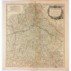
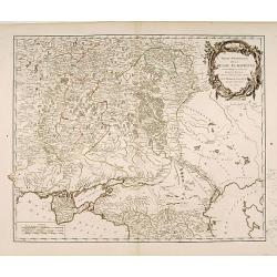
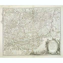
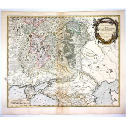
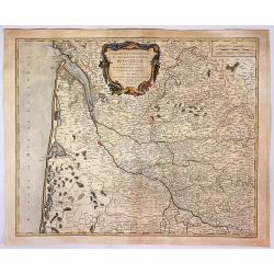
Le Cercle de Baviere Qui Comprend le Haut Palatinat, les Duchés de Haute et Basse Baviere et de Neuburg, L'Archevéché de Salzburg...
An interesting regional map, extending from Waldeck in the North to Efferding on the Danube in the East, Saltzberg and the Tyrolian Alps in the South, and Dillingen on th...
Date: Paris, 1751
Selling price: ????
Please login to see price!
Sold in 2017
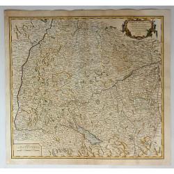
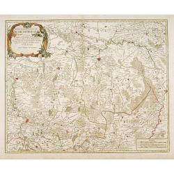
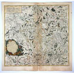
Cercle de Souabe...
The Circle of Swabia, or Swabian Circle, was an Imperial Circle of the Holy Roman Empire established in 1500 on the territory of the former German stem-duchy of Swabia. T...
Date: Paris, 1751
Selling price: ????
Please login to see price!
Sold in 2018
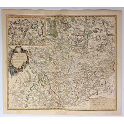
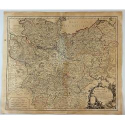
Cercle de Westphalie Divise en Tout Ses Etats et Souverainetes.
A fine map of Westphalia by Vaugondy in 1751. The Lower Rhenish–Westphalian Circle was an Imperial Circle of the Holy Roman Empire. It comprised territories of the form...
Date: Paris, 1751
Selling price: ????
Please login to see price!
Sold in 2018
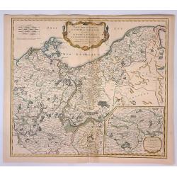
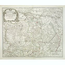
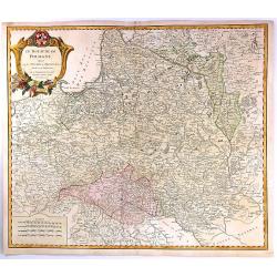
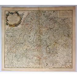
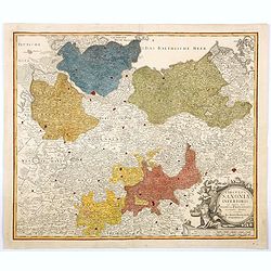
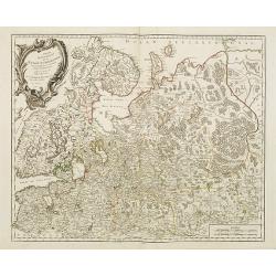
Partie Septentrionale du Cercle de Haute Saxe qui contient le Duche de Pomeranie et le Marquisat de Brandebourg...
A stunning map of the northern portion of Upper Saxony, in what is now northeast Germany and Northwest Poland. It includes the Duchy of Pomerania and Brandenburg, and ext...
Date: Paris, 1751
Selling price: ????
Please login to see price!
Sold in 2018
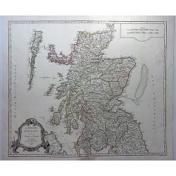
Le Royaume D'Ecosse divisee en Shires ou Comtes.
A striking and detailed map of Scotland, from Vaugondy's “Atlas Universel”. It includes towns, cities, mountains, rivers and lakes. Interestingly shaped rococo decor...
Date: Paris, 1751
Selling price: ????
Please login to see price!
Sold in 2018
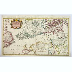
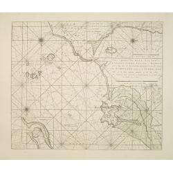
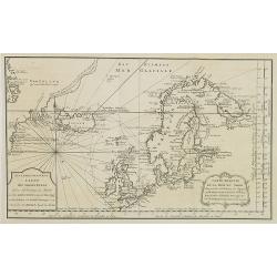
Sinus Finnici Delineatio Geographica ex quam pluriminis subsidiis novissimis stereographice tradita per Dm. Tobiam Majerum. . . Professorem . . .
A fine mid-18th century two sheet map of the Gulf of Finland with its surroundings (Åland, Southern Finland, Inkerinmaa, Estonia, Karjalankannas, Uppland). St. Petersbur...
Date: Nuremberg, 1751
Selling price: ????
Please login to see price!
Sold in 2018
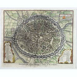
Bruges one of the Principal Cities of Flanders.
A birds-eye plan of the lovely Belgian city of Bruges, seen here within its ancient walls and fortifications. A number of bridges and windmills are shown, along with pict...
Date: London, ca 1751
Selling price: ????
Please login to see price!
Sold in 2019
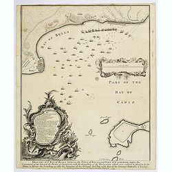
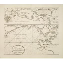
Draught of the Bay of Bulls between the Town of Rotta and Fort St. Catherine. . .
A large plan of the Bay of Bulls in southern Spain, outlining a military action fought by the English there, as part of the ongoing 'War of the Spanish Succession' - foug...
Date: London, ca 1751
Selling price: ????
Please login to see price!
Sold in 2020
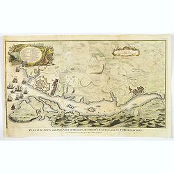
Plan of the Town and Harbour of mahon, St. Philip's Castle, and its Fortifications.
An attractive bird's-eye plan of Mahon and its fortifications and surrounds in the mid eighteenth century. You see the town plan of Mahon, the capitol of the Balearic isl...
Date: London, 1751
Selling price: ????
Please login to see price!
Sold in 2019
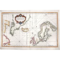
CARTE REDUITE DES MERS DU NORD. Pour serive aux Vaisseaux du Roy.
A large, striking hand-colored map of the North Sea, depicting the Scandinavia peninsula, the United Kingdom, Greenland, east coasts of today's US and Canada and centered...
Date: Paris, 1751
Selling price: ????
Please login to see price!
Sold in 2019
![Partie septentrionale du cercle de Haute Saxe [...] Brandebourg.](/uploads/cache/44152-250x250.jpg)
Partie septentrionale du cercle de Haute Saxe [...] Brandebourg.
Finely and crisply engraved map of north eastern part of Germany, including part of Poland. With inset map of Brandenburg. Map by Robert De Vaugondy with an ornamental ti...
Date: Paris, ca 1751
Selling price: ????
Please login to see price!
Sold in 2020
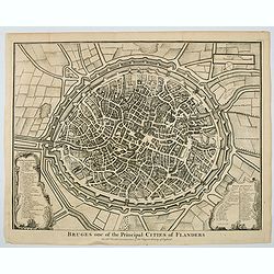
Bruges one of the Principal Cities of Flanders.
A birds-eye plan of the lovely Belgian city of Bruges, seen here within its ancient walls and fortifications. A number of bridges and windmills are shown, along with pict...
Date: London, ca 1751
Selling price: ????
Please login to see price!
Sold in 2023
Partie Méridionale de la Russie Européenne..
Detailed map of Ukraine, the Crimea and the northern part of the Caspian Sea.
Date: Paris 1752
Selling price: ????
Please login to see price!
Sold
Plan de Nancy Avec les Changements que le Roy de Pologne Duc de Lorraine et de Bar a fait Dedié à sa Majesté Polonoise Par Le Rouge
A Rare plan of Nancy by Georges-Louis le RougeA large and detailed copper engraved plan of Nancy, published by le Rouge in 1752. Surrounded by important buildings of the ...
Date: Paris, 1752
Selling price: ????
Please login to see price!
Sold in 2011
Partie septentrionale du duche de Brabant
A handsome map of the Northern half of Brabant, includes the area north of Mechelen. Includes a decorative title cartouche and a set of scales.Relief shown pictorially.
Date: Paris 1752
Selling price: ????
Please login to see price!
Sold
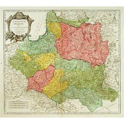
Le Royaume de Pologne..
Detailed map of Poland, including Lithuania, Ukraine, East Prussia, etc.
Date: Paris 1752
Selling price: ????
Please login to see price!
Sold
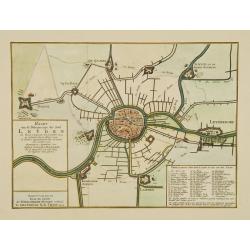
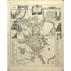
Kaart van de belegeringe der stad Leyden..
Very detailed map of the siege of Leiden from 1573-1574. With extensive key to the important building in the town. After a design by Joost Janssen Bilhamer.
Date: Amsterdam, 1752
Selling price: ????
Please login to see price!
Sold
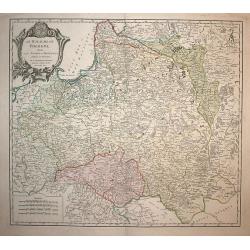
Le Royaume de Pologne,
Detailed map of Poland. The map is filled with towns and topographic details like the river systems. An exquisite cartouche surrounds the title at the top.
Date: Paris, 1752
Selling price: ????
Please login to see price!
Sold in 2008
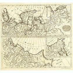
![[4 maps] Partie Orientale de l'Empire de Russie ? / Partie Occidentale de l'Empire de Russie ? / Partie Septentrionale de la Russie Européenne ? / Partie Méridionale de la Russie Européenne ?](/uploads/cache/99444-250x250.jpg)
[4 maps] Partie Orientale de l'Empire de Russie ? / Partie Occidentale de l'Empire de Russie ? / Partie Septentrionale de la Russie Européenne ? / Partie Méridionale de la Russie Européenne ?
Detailed maps of the different regions of Russia.
Date: Paris, 1752
Selling price: ????
Please login to see price!
Sold in 2010
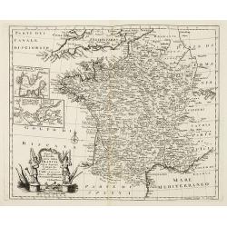
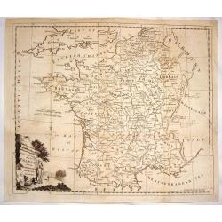
Nuova ed Esatta carta della Francia. . .
General map of France, after Emanuel Bowen, but from an Italian text edition. With an elegant baroque title cartouche. With inset charts of the harbors of Toulon & Br...
Date: London, 1752
Selling price: ????
Please login to see price!
Sold
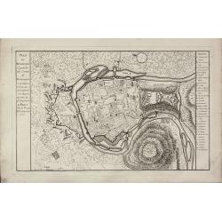
Plan de Besancon. Capitalle du Compté de Bourgogne.
A rare plan of Besancon in the Bourgogne by Le Rouge. Showing the fortified city with the adjacent streets, title to the left, and a keys to the right. We could not locat...
Date: Paris, 1752
Selling price: ????
Please login to see price!
Sold
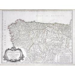
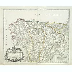
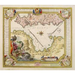
Partie Septentrionale de la Couronne de Castille ou se trouvent Les Royaumes de Castille Vieille de Leon, de Gallice, des Asturies, La Biscaye et la Navarre...
Highly detailed map of Northwestern Spain, including the regions of Gallicia, Leon, Asturias, Castille and Biscaya by Robert de Vaugondy. In the southern portion of the m...
Date: Paris, 1752
Selling price: ????
Please login to see price!
Sold in 2010
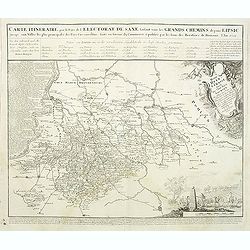
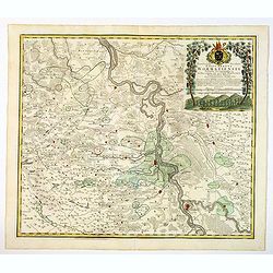
Carte Itineraire par le Pays de l'Electorat de Saxe faisant voir les Grands Chemins depuis Lipsic jusqu' aux Villes les plus principales des Pays Circonvoisins. . .
Detailed map of post road mapsroad system around Leipzig, prepared by J. C. K. Reichenb. Varisco in 1728. The map has a French title in top and the distances marked betwe...
Date: Nuremberg, 1752
Selling price: ????
Please login to see price!
Sold in 2011
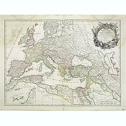
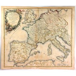
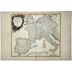
Romani Imperii occidentalis . . .
Striking and highly detailed map of the Roman Empire, extending from the British Isles to North Africa, the Black Sea, Caspian Sea and Persian Gulf. From his "Atlas ...
Date: Paris, 1752
Selling price: ????
Please login to see price!
Sold in 2011
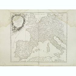
Imperium Caroli Magni Occidentis Imperatoris. . .
Attractive and detailed map of Charlemagne's empire, covering the British Isles, Denmark, the Low Countries, Germany, France, Spain, Switzerland, Austria, Italy, Hungary,...
Date: Paris, 1752
Selling price: ????
Please login to see price!
Sold in 2011
Partie Meridion. du Duche de Brabant. . .
Detailled map of a part of Belgique from his "Atlas Universel".Gilles Robert de Vaugondy (1688–1766), also known as Le Sieur or Monsieur Robert, and his son, ...
Date: Paris, 1752
Selling price: ????
Please login to see price!
Sold in 2013
Partie septentrionale du duche de Brabant
A handsome map of Noord Brabant from his "Atlas Universel." Gilles Robert de Vaugondy (1688–1766), also known as Le Sieur or Monsieur Robert, and his son, Did...
Date: Paris, 1752
Selling price: ????
Please login to see price!
Sold in 2011
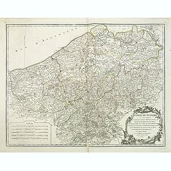
Comté de Flandre. . .
Detailled map of Flanders from his "Atlas Universel", with the privilege.Gilles Robert de Vaugondy (1688–1766), also known as Le Sieur or Monsieur Robert, and...
Date: Paris, 1752
Selling price: ????
Please login to see price!
Sold in 2011
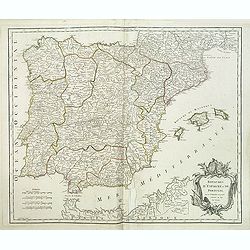
Royaumes d'Espagne et de Portugal.
Detailed map of Spain, Portugal and Baleares islands. Showing also south part of Franc and north Africa from his "Atlas Universel".Gilles Robert de Vaugondy (16...
Date: Paris, 1752
Selling price: ????
Please login to see price!
Sold in 2015
Partie septentrionale de la Couronne de Castille.
Detailed map of the northern part of Spain. Also depicting a small part of northern Portugal from his "Atlas Universel." Gilles Robert de Vaugondy (1688–1766)...
Date: Paris, 1752
Selling price: ????
Please login to see price!
Sold in 2011
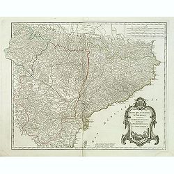
Etats de la Couronne d'Aragon. . .
Decorative map of the Kingdom of Aragon, with cartouche and coat of arms. Numerous place-names of counties, cities, towns, physical features from his "Atlas Universe...
Date: Paris, 1752
Selling price: ????
Please login to see price!
Sold in 2015
Le Royaume d'Ecosse.
Detailed map of Scotland, from a later edition of DeVaugondy's Atlas Universel. Includes towns, mountains, rivers, lakes and a host of other details. Decorative Cartouche...
Date: Paris, after 1752
Selling price: ????
Please login to see price!
Sold in 2014
A view of the Exchange the South and North Blaak taken from the Gaapers Bridge ROTTERDAM - Vue de la Bourse. . .
So-called optical print. Fine panoramic view of the exchange of Rotterdam, with many people on the foreground.Underneath : "Published according to Act of Parliament&...
Date: London, after 1752
Selling price: ????
Please login to see price!
Sold in 2014
A New and Accurate Map of France with the Netherlands From the Best Authorities.
An interesting map featuring a rural cartouche with a woman holding a cross and looking at a papal crown and chalais laying on the ground. Emanuel Bowen (1714-1767), ma...
Date: London, 1752
Selling price: ????
Please login to see price!
Sold in 2015
Partie Meridion. du Duche de Brabant.
Detailed map of a part of Belgium from his "Atlas Universel".Gilles Robert de Vaugondy (1688–1766), also known as Le Sieur or Monsieur Robert, and his son, Di...
Date: Paris, 1752
Selling price: ????
Please login to see price!
Sold in 2014
Sibirie maxime Septentrionalis pars a Nova Semlja in oceanum orientalem . . .
Scarce map of Siberia engraved by Johann Eberhard Alber, who was a German copper engraver active from 1742-1757.
Date: Nuremberg, 1752
Selling price: ????
Please login to see price!
Sold in 2014
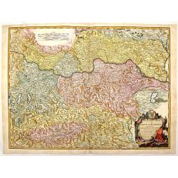
Partie Septentrionale du Cercle D'Autriche Qui Comprend L'Archiduche D'Autriche.
A pleasing map of North Austria centered around the Danube River which flows through the top part of the map through Vienna. Large title cartouche is featured in the righ...
Date: Paris, 1752
Selling price: ????
Please login to see price!
Sold in 2018
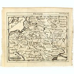
Pologne.
Scarce small map of Poland based on cartography of Guillaume Delisle (. Published in "Nouveau traité de geographie par M**** ", published by La veuve Lottin &a...
Date: Paris, 1752
Selling price: ????
Please login to see price!
Sold in 2015
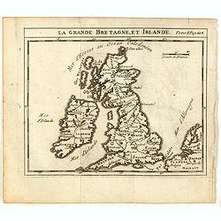
La Grande Bretagne, et Irlande.
Scarce small map of Great Britain of based on cartography of Guillaume Delisle (. Published in "Nouveau traité de geographie par M**** ", published by La veuve...
Date: Paris, 1752
Selling price: ????
Please login to see price!
Sold in 2015
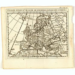
L'Europe suivant Mr. De Lisle de L'Academie Royale des Scienes.
Scarce small map of Europe based on cartography of Guillaume Delisle (. Published in "Nouveau traité de geographie par M**** ", published by La veuve Lottin &a...
Date: Paris, 1752
Selling price: ????
Please login to see price!
Sold in 2017
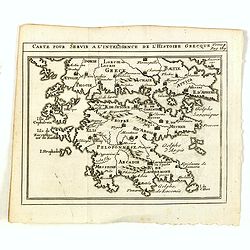
Carte pour servir a l'intelligence de l'histoire Grecque.
Scarce small map of Greece based on cartography of Guillaume Delisle. Published in "Nouveau traité de geographie par M**** ", published by La veuve Lottin &...
Date: Paris, 1752
Selling price: ????
Please login to see price!
Sold in 2020
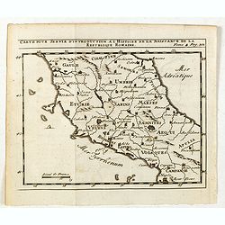
Carte pour servir d'introduction à l histoire de la naissance de la republique Romaine.
Scarce small map of central Italy based on cartography of Guillaume Delisle (. Published in "Nouveau traité de geographie par M**** ", published by La veuve Lo...
Date: Paris, 1752
Selling price: ????
Please login to see price!
Sold in 2015
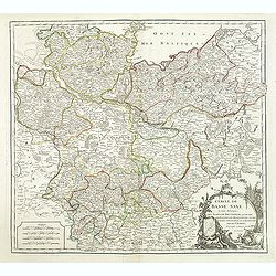
Cercle de Basse Saxe. . .
Detailed map of Northern Germany. Relief shown pictorially. Ornamental cartouche from his "Atlas Universel".Gilles Robert de Vaugondy (1688–1766), also known ...
Date: Paris, 1752
Selling price: ????
Please login to see price!
Sold in 2015
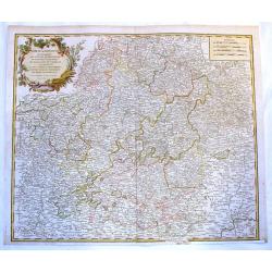
Cercle de Franconie Qui Comprehend Les Eveches de Wurtzbourg.
Fine Vaugondy map of Franconia, Germany centered on Würtzburg, Nuremberg & Bamberg. Engraved by Catherine Haussard and included in "ATLAS UNIVERSELLE". Fea...
Date: Paris, 1752
Selling price: ????
Please login to see price!
Sold in 2017
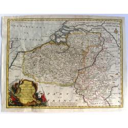
A New & Accurate Map of the Netherlands or Low Countries.
Fine copper-engraved map with good detail of roads, towns, and canals. Also shown are the Barrier Towns as designated by the Barrier Treaty, concluded at Antwerp in 1715...
Date: London, 1752
Selling price: ????
Please login to see price!
Sold in 2018
Le Royaume de Pologne, divise en ses duches et Provinces, et subdivise en Palatinats
A fine map of the Kingdom of Poland by Vaugondy. It features Poland, Lithuania and parts of the Russian Empire, Transylvania and Latvia. The map details both topographica...
Date: Paris, 1752
Selling price: ????
Please login to see price!
Sold in 2016
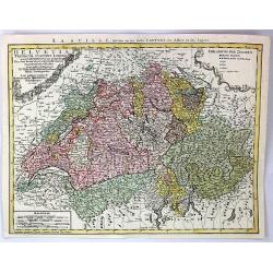
Helvetia Tredicim Statibus Liberis.
Detailed map of Switzerland along with parts of Italy, France, Germany, and Austria. The map notes fortified cities, villages, roads, bridges, forests, castles, and topog...
Date: Nuremberg, 1752
Selling price: ????
Please login to see price!
Sold in 2016
Imperium Caroli Magni Occidentis Imperations.
A pleasing map of Europe and the Empire of Charlemagne by Vaugondy. It covers Europe and the European Empire of Charles the Great from England south as far as northern Af...
Date: Paris, 1752
Selling price: ????
Please login to see price!
Sold in 2018
Partie Septentrionale du Cercle D'Autriche
A fine map of northern Austria by Robert de Vaugondy. It covers from Radstadt north to Scharding and east as far as Bratislava.The entire region is depicted in detail, of...
Date: Paris, 1752
Selling price: ????
Please login to see price!
Sold in 2017
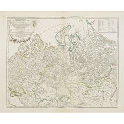
Partie Meridionale de la Russie Europeenne...
Large, finely engraved map showing topographical detail of mountains, rivers, lakes and forests. Moscow is in the upper center of the map and the Volga River in the east ...
Date: Paris , 1752
Selling price: ????
Please login to see price!
Sold in 2018
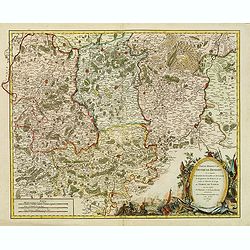
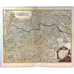
Partie Septentrionale du Gouvernement General de Bourgogne...
A detailed regional map with a large decorative Rococo cartouche. Shows fortified cities, towns, rivers, castles, churches, roads, woods, mountains, lakes, etc. It covers...
Date: Paris , 1752
Selling price: ????
Please login to see price!
Sold in 2018
Cercles de Basse Saxe.
A German map including the northern Duchy's of Holstein, Mecklenbourg, Eveches, Hildesheime and Halbersstadt, including the river Elbe, with Hamburg until Potsdam.In the ...
Date: Paris, 1752
Selling price: ????
Please login to see price!
Sold in 2017
Cercle de Franconie...
A detailed 1752 map of the Circle of Franconia, Germany by de Vaugondy. Franconia is a region in Germany, and it commonly refers to the eastern part of the historical Fr...
Date: Paris, 1752
Selling price: ????
Please login to see price!
Sold in 2019
Partie Orientale du Gouvernement General de la Guienne...
A pleasing map of the Eastern Guyenne region of France by Vaugondy. It depicts the southern portion of France from Samatan east, to Bruide, and south as far as Toulouse, ...
Date: Paris, 1752
Selling price: ????
Please login to see price!
Sold in 2019
Territorium Seculare Episcopatus Wormatiensis. . .
Johann Baptist Homann's well-engraved map has a large decorative title cartouche with a vineyard and two vine tendrils with the episcopal coat of arms. A fine and detaile...
Date: Nuremberg, 1752
Selling price: ????
Please login to see price!
Sold in 2020
Imperium CAROLIMAGNI Occidentis Imperatoris.
An attractive and detailed map of Charlemagne's empire, covering the British Isles, Denmark, the Low Countries, Germany, France, Spain, Switzerland, Austria, Italy, Hunga...
Date: Paris, 1752
Selling price: ????
Please login to see price!
Sold in 2020
Circulus Saxoniae Inferioris in omnes suos Status et Principatus. . .
Homann's detailed map of Germany's Lower Saxony region, extending from the Baltic to Berlin, Hall, Gottingen, Bremen and Minden, centered on the course of the Elbe River....
Date: Nuremberg, ca 1752
Selling price: ????
Please login to see price!
Sold in 2021
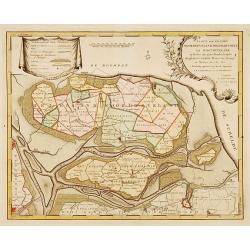
Kaarte der ..Noordbeveland, Wolphartsdyk en Oostbeveland..
Detailed map prepared by D.W.C. Hattinga in 1751. Isaac Tirion was born in Utrecht ca. 1705. He came to Amsterdam ca. 1725. Tirion published a number of important books, ...
Date: Amsterdam 1753
Selling price: ????
Please login to see price!
Sold

Vue de l'Amirauté et de ses environs.
Fine view of the admiralty buildings in St.Petersburg. Drawn and engraved under the direction of the imperial Academy of sciences and arts of Russia. After a design by De...
Date: Saint-Petersburg 1753
Selling price: ????
Please login to see price!
Sold
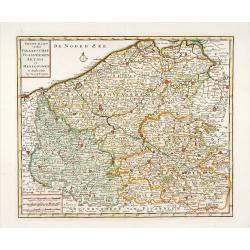
Nieuwe kaart van het Graafschap Vlaanderen, Artois. . .
Detailed map of western part of present day Belgium. Published by Isaäk Tirion in deLuxe edition of "Handatlas der geheele Aarde", Amsterdam, 1753.
Date: Amsterdam, 1753
Selling price: ????
Please login to see price!
Sold in 2020
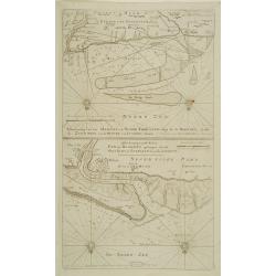
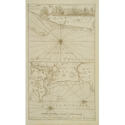
Aftekening van het Margat.. / Afteekening van de Rivier Cly en Blakeny geleegen aan de Oostkust van Engeland..
Latitude scale, compass rose and system of rhumb lines, soundings, anchorage's, etc. A wealth of cities and information appear in the chart.
Date: Amsterdam 1753
Selling price: ????
Please login to see price!
Sold
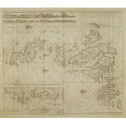
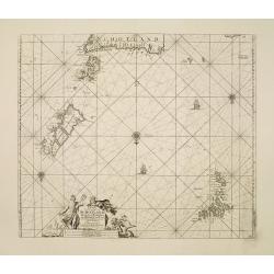
Nieuwe afteekening van de Eylanden van Fero..
Very rare: included in 6th volume, so-called secret atlas of the V.O.C. of Van Keulen. Latitude scale, compass rose and system of rhumb lines, soundings, anchorage's, etc...
Date: Amsterdam 1753
Selling price: ????
Please login to see price!
Sold
De Reede van \'t Leith van Edenburgh. / Afteekening van Nieuw en Oud Aberdeene ..
Latitude scale, compass rose and system of rhumb lines, soundings, anchorage\'s, etc. A wealth of cities and information appear in the chart. In upper right corner inset ...
Date: Amsterdam 1753
Selling price: ????
Please login to see price!
Sold
Afteekening van Scarbough Wicke.. / Afteekening van Hartlepoole ..
Latitude scale, compass rose and system of rhumb lines, soundings, anchorage\'s, etc. A wealth of cities and information appear in the chart.
Date: Amsterdam 1753
Selling price: ????
Please login to see price!
Sold in 2009
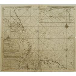
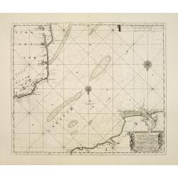
A new-enereasing Compass Map of part of the east coast of England..
Latitude scale, compass rose and system of rhumb lines, soundings, anchorage's, etc. A wealth of cities and information appear in the chart.The address is now updated to ...
Date: Amsterdam 1753
Selling price: ????
Please login to see price!
Sold in 2008
De Oost zee of Öster Siöön.
Latitude scale, compass rose and system of rhumb lines, soundings, anchorage's, etc. A wealth of cities and information appear in the chart.Printed on two joined sheets o...
Date: Amsterdam 1753
Selling price: ????
Please login to see price!
Sold
De rivier van Kingsale is geleegen aan de zuyd kust van Irland..
Latitude scale, compass rose and system of rhumb lines, soundings, anchorage's, etc. A wealth of cities and information appear in the chart. Latitude scale, compass rose ...
Date: Amsterdam 1753
Selling price: ????
Please login to see price!
Sold
Nieuwe aftekening van Holy Eyland de Staples, coket Eyland en Barwyk .. Aan de ioostkust van Schotland..
Latitude scale, compass rose and system of rhumb lines, soundings, anchorage's, etc. A wealth of cities and information appear in the chart. Latitude scale, compass rose ...
Date: Amsterdam 1753
Selling price: ????
Please login to see price!
Sold in 2008
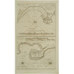
Paskaart Vande Noord Cust van Schotland als mede de Eylanden van Hitland en Fero..
South to the top. Latitude scale, compass rose and system of rhumb lines, soundings, anchorage's, etc. In lower right corner with added number 26.A wealth of cities and i...
Date: Amsterdam 1753
Selling price: ????
Please login to see price!
Sold in 2008
A new gradually encreasnig compass-map of the commingin of the Channel, or the Heads..
Title in Dutch, English and French. Showing the crossing of the Channel between Calais and Dover.Latitude scale, compass rose and system of rhumb lines, soundings, anchor...
Date: Amsterdam 1753
Selling price: ????
Please login to see price!
Sold
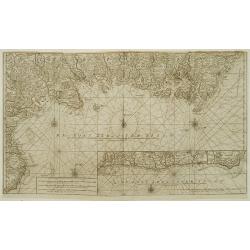
A new gradually encreasing compass-map, of a part the Sea Coasts of England .. Dorsetshire .. Hampshire ..
Title in Dutch and English. Showing the coasts of Dorset with Poole and Weymouth.Latitude scale, compass rose and system of rhumb lines, soundings, anchorage's, etc. In l...
Date: Amsterdam 1753
Selling price: ????
Please login to see price!
Sold
A new gradually encreasing compass-map, of a part the Sea Coasts of England .. Sussex .. Hastings to Arundel ..
Title in Dutch and English. Showing the coast of Sussex.Latitude scale, compass rose and system of rhumb lines, soundings, anchorage's, etc. In lower right corner with ad...
Date: Amsterdam 1753
Selling price: ????
Please login to see price!
Sold
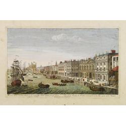
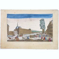
A View of the Custom House with part of the Tower taken from ye River Thames London.. Publish'd according to Act of Parliament 1753.
Very decorative, so-called optical print illustrating the river Thames with the Custom House with part of the Tower of London.In the eighteenth and nineteenth centuries t...
Date: London, 1753
Selling price: ????
Please login to see price!
Sold
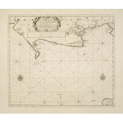
Plan du siege de Corfu par Terre et par Mer.
Uncommon map of the western coast of Corfu, including the town of Kérkira and its siege on July 5th, 1716. Upper part the coast of the Greek province of Sarande. Well-en...
Date: Nuremberg, 1753
Selling price: ????
Please login to see price!
Sold in 2010
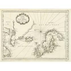
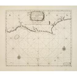
Karte von den Nord-Meeren zur allgemeinen Historie der Reisen...
Map of the North sea with coastlines of Greenland, Iceland and Norway. In: Allgemeine Historie der Reisen zur Wasser und zu Lande: oder Sammlung aller Reisebeschreibungen...
Date: Leipzig, 1753
Selling price: ????
Please login to see price!
Sold in 2011
Partie Occidentale de l'Empire de Russie ou se trouve distinguée la Russie Européenne. . .
Detailed map of the European part of Russia.
Date: Paris, 1753
Selling price: ????
Please login to see price!
Sold in 2008
Partie Septentrionale de la Russie Européenne . . .
Detailed map of European part of Russia, including Finland, Lapland.
Date: Paris, 1753
Selling price: ????
Please login to see price!
Sold in 2008
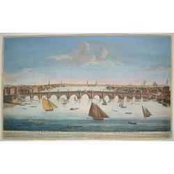
A View of Weftminfter Bridge / Vue du Pont de Weftminfter
A scarce, beautifully engraved view of Westminster Bridge and London. The work was originally executed by Boyer. Many key London sites are depicted in the background, inc...
Date: London, dated 1753
Selling price: ????
Please login to see price!
Sold in 2010
Carte reduite de la Mer du Nord. . . / Zusammengezogene Karte des Nordmeeres. . .
Map of the North Atlantic Ocean. In: Allgemeine Historie der Reisen zur Wasser und zu Lande: oder Sammlung aller Reisebeschreibungen.. in Englischen zusammen getragen, un...
Date: Leipzig, 1753
Selling price: ????
Please login to see price!
Sold in 2008