Browse Listings in Australia & Oceania > Oceania
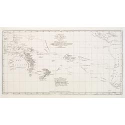
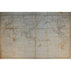
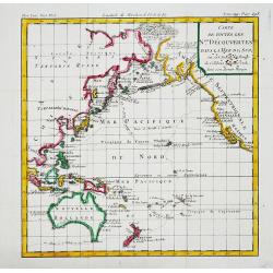
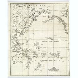
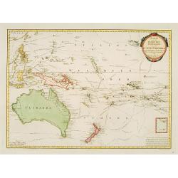
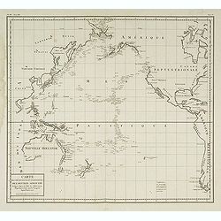
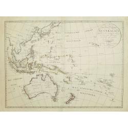
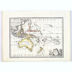
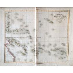
Charte von einem Theile des Süd-Meeres..
Map of the southern Pacific Ocean with Australia, New Zealand, and South America.
Date: Berlin 1780
Selling price: ????
Please login to see price!
Sold
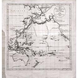
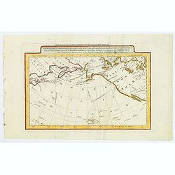
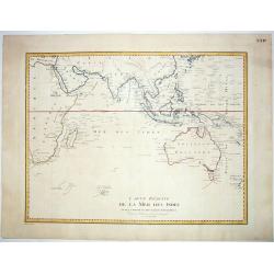
Carte de l'Océan Pacifique au Nord de l'Equateur. . .
The earliest folio-sized printed map of Cook's third voyage, on which he became the first European to discover Hawaii. On this voyage, he also explored the Northwest coas...
Date: Augsburg 1781
Selling price: ????
Please login to see price!
Sold in 2013
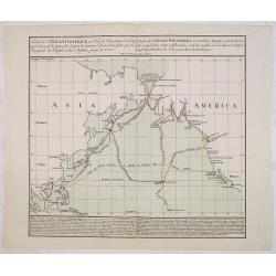
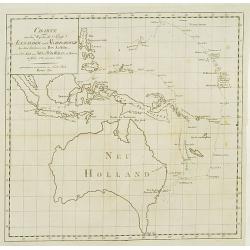
Carte welche die Fahrt und Endeckungen der Capitäns Cook, Clerke und Gore in den Iahren 1776 - 1780 vorstellt
Map of the Pacific Ocean, including Australia and New Zealand, depicting the voyages of Cook, Clerke und Gore during the years 1776 - 1780. From the rare German translati...
Date: Berlin, 1781
Selling price: ????
Please login to see price!
Sold in 2014
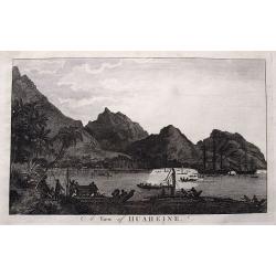
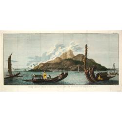
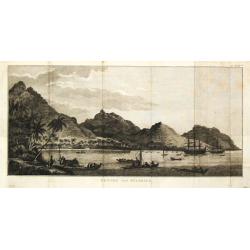
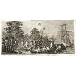
A view of Huaheine.
Detailed view of Cook's landing at Huahine Island in French Polynesia. Shows numerous people and canoes greeting the two sailing ships Resolution & Discovery. A large...
Date: London, ca. 1784
Selling price: ????
Please login to see price!
Sold in 2016
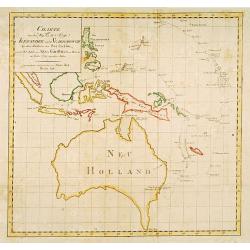
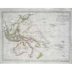
Carte Générale Offrant les Découvertes faites par le Capitaine Jacques Cook dans ce Voyage et dans les deux Voyages précédens ...
From the French edition of James Cook's third voyage entitled Troisième Voyage de Cook, ou Voyage à l'Océan Pacifique, ordonné par le Roi d'Angleterre, pour faire des...
Date: Paris, 1785
Selling price: ????
Please login to see price!
Sold in 2010
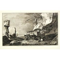
Carte de la Terre Van-Diemen.
From the French edition of James Cook's third voyage entitled Troisième Voyage de Cook, ou Voyage à l'Océan Pacifique, ordonné par le Roi d'Angleterre, pour faire des...
Date: Paris, 1785
Selling price: ????
Please login to see price!
Sold in 2010
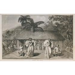
Danse d'O-taïti.
From the French edition of James Cook's third voyage entitled Troisième Voyage de Cook, ou Voyage à l'Océan Pacifique, ordonné par le Roi d'Angleterre, pour faire des...
Date: Paris, 1785
Selling price: ????
Please login to see price!
Sold in 2010
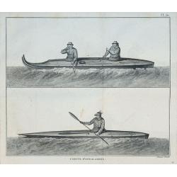
Canots d'Oonalashka.
From the French edition of James Cook's third voyage entitled Troisième Voyage de Cook, ou Voyage à l'Océan Pacifique, ordonné par le Roi d'Angleterre, pour faire des...
Date: Paris, 1785
Selling price: ????
Please login to see price!
Sold in 2010
Carte de toutes les N.les Découvertes dans la Mer du Sud, ou est tracee la Route du Celebre Capitain Cook.
An attractive small map of the Pacific with the tracks of Captain Cook's last voyage made in 1777-79.
Date: Paris, c.1785
Selling price: ????
Please login to see price!
Sold in 2017
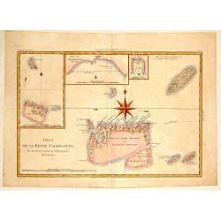
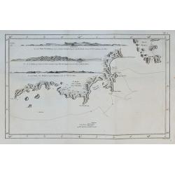
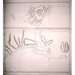
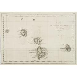
Isles de la Reine Charlotte.
A detailed chart of the Santa Cruz islands, to the north of the New Hebrides, including an inset chart of Carteret and Gower Islands, Baye de L'Hirondelle and Havre de By...
Date: Paris, 1787
Selling price: ????
Please login to see price!
Sold in 2015
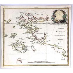
Carte des Isles de Papous
A rare and highly detailed map of Papua New Guinea, and neighbouring islands around New Guinea, South-East Asia.From Philippe de Pretot's Atlas. Features a fine floral ti...
Date: Paris, 1787
Selling price: ????
Please login to see price!
Sold in 2018
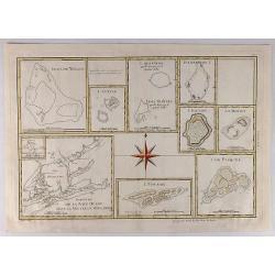
Esquisse de la Baye Dusky dans la Nouvelle Zeelande.
Group of hand colored engraved maps of Pacific islands in compartments on one sheet. These islands were described by Captain James Cook on one of his expeditions between ...
Date: Paris, 1787
Selling price: ????
Please login to see price!
Sold in 2018
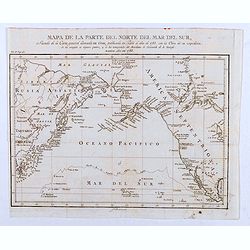
Mapa de la Parte del Norte del Mar del Sur, Sacado Dela Carta General Llamada de Cook, Publicada en Paris el Año de 1785. . .
Map of the Northern Part of the Pacific Ocean, taken from the "General Letter of Cook's Call. Published in Paris in the Year of 1785. With the Work of his Expedition...
Date: Madrid, 1788
Selling price: ????
Please login to see price!
Sold in 2020
Norfolk Island ; S. end of Norfolk Island.
Norfolk Island ; S. end of Norfolk Island by W. Bradley delin. 1788. Published by J Stockdale August 10th 1789 printed by W. Harrison & J. Reid sc. Map of Norfolk Isl...
Date: London, 1789
Selling price: ????
Please login to see price!
Sold in 2014
Polynesien (Inselwelt) oder der Fünfte Welttheil Verfasst von Herrn Djurberg. . .
One of the first maps to use the name Ulimaroa, originally published in Sweden in 1780. In the first state, it was the first map to use the Maori term Ulimaroa for Austr...
Date: Vienna, Philipp Josef Schalbacher, 1789
Selling price: ????
Please login to see price!
Sold in 2019
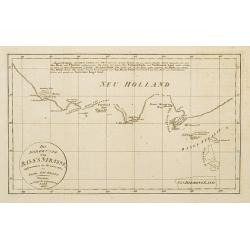
Fahrt des Lieut. William Bligh von Tofoa.. Timor..
Uncommon map showing the track of Wimmiam Bligh in 1789 on his ship Bounty Jakarta to Timor. With 3 inset maps: East coast of New Holland.Bligh's Islands and the Hebrides...
Date: Berlin 1790
Selling price: ????
Please login to see price!
Sold
Charte von dem weg den die Schiffe Alexander..
Fine and rare map of Australia and Indonesia and the Philippines. Showing the track, from Port Jackson in New South Wales to Batavia, of the vessels Alexander and Scarbor...
Date: Berlin 1790
Selling price: ????
Please login to see price!
Sold
Charte von dem weg den die Schiffe Alexander..
Fine map of Australia and Indonesia and the Philippines. Showing the track, from Port Jackson in New South Wales to Batavia, of the vessels Alexander and Scarborough in t...
Date: Berlin 1790
Selling price: ????
Please login to see price!
Sold
A chart Shewing the Tracks & Discoveries in The Pacific Ocean Made By Capt. Cook and Capt. Clerke..
Map of Pacific Ocean showing tracks of Resolution and Discovery in the years 1777-1780 made by Capt. Cook and Capt. Clerke. Engraved by Matthew Smith.
Date: London 1790
Selling price: ????
Please login to see price!
Sold
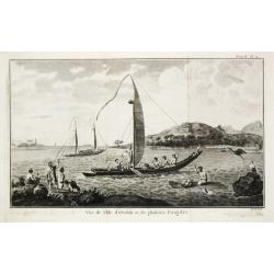
Vue de l' Isle d' Otahiti et de plusieurs Pirogues.
Captain James Cook (1728-79), explorer, circumnavigator and hydrographer. Three voyages, 1768-71, 1772-75 and 1776-79. From 1778 on printed editions of' Captain Cook's Tr...
Date: Paris, c. 1790
Selling price: ????
Please login to see price!
Sold
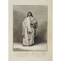
Uomai, nativo di Ulaietea condotto in Inghilterra nell' anno 1774 da Tobia Furneaux, Gentiluomo Inglese. / Omai, natif d'Ulaietea Conduit en Angleterre dans l'an 1774 par Tobie Furneaux, Gentilhomme Anglois.
Full portrait of an Omai, a Native of Ulaietea, was brought into England in 1774 by Tobias Furneaux. Probably based on a drawing by Nathaniel Dance Holland (1734-1811).A ...
Date: Venice, Antonio Zatta, c.1790
Selling price: ????
Please login to see price!
Sold in 2012
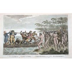
The landing of Captn. Cook, &c at Erramanga, one of the New Hebrides.
Copper engraved scene at Eromanga in the nation of today's Vanuatu during Cook's second voyage. Shows Captain Cook with his gun and his crew in a small boat fighting with...
Date: London, ca. 1790
Selling price: ????
Please login to see price!
Sold in 2016
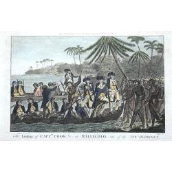
The landing of Captn. Cook, &c at Mallicolo, one of the New Hebrides.
Copper engraved scene on the island of Malakula in Vanuatu. Shows two of Captain Cooks boats with his crew landing on the island during Cook's second voyage. By Alexander...
Date: London, ca. 1790
Selling price: ????
Please login to see price!
Sold in 2016
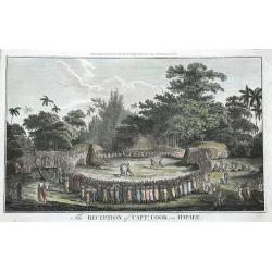
The Reception of Captn. Cook, in Hapaee.
The Ha'apai islands were named by Captain Cook the Friendly Islands, today's Tonga. Shown are a large group of Polynesians watching a boxing fight and a fight with clubs....
Date: London, ca. 1790
Selling price: ????
Please login to see price!
Sold in 2016
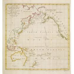
A Chart exhibiting the New Discoveries in the North & South Pacific Ocean, also those on the Northwest Coast of America.
A copper engraved map that was made only a few years after Cook's voyage to Australia. The map shows Port Jackson and other settlements in New South Wales. Other discover...
Date: London, ca 1790
Selling price: ????
Please login to see price!
Sold in 2018
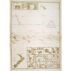
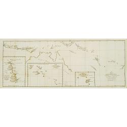
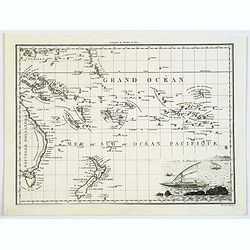
Carte d'une Partie de la Mer du Sud..
Covering the area from lower left New Zealand, up to Hawaii in the top. With 46 insets of islands in the South Pacific.
Date: Paris 1791
Selling price: ????
Please login to see price!
Sold
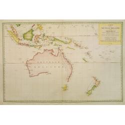
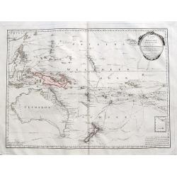
Carte de la Nouvelle Hollande et des Archipels..
Large map centered on Australia, whose southeastern seacoast is not delineated. It includes Indonesia and New Zealand. Just part of Tasmania is outlined.The title informs...
Date: Paris, 1791
Selling price: ????
Please login to see price!
Sold in 2008
Karte von Australien oder Polynesien nach den Zeichnungen Reisebeschreibungen
Map of Australia, the S.W. Pacific, and Indonesia showing Australia lettered New Holland with Tasmania joined to the mainland. It also shows the tracks of Tasman, Cook, F...
Date: Nuremberg 1792
Selling price: ????
Please login to see price!
Sold
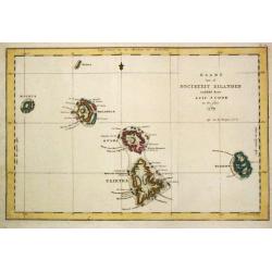
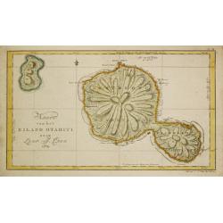
Kaart van de Societeit Eilanden ontdekt door Luit. J. Cook in het jaar 1769. N° 111.
Map of the islands of Maurua, Bolabola, Otaha, Ulietéa and Huaheine. In upper right corner "N° III". As James Cook writes in his journal on page 39 : "So...
Date: Amsterdam, 1793
Selling price: ????
Please login to see price!
Sold in 2008
Karte von der Inselwelt Polynesien..
An attractive map of Australia, S.E.Asia, New Guinea and New Zealand showing the tracks of several explorers including those of Cook's three voyages. Australia and New Ze...
Date: Vienna 1795
Selling price: ????
Please login to see price!
Sold
Gezigt van het eiland Otahiti op den afstand van eene zee-mijl in het Z.O.
Captain James Cook (1728-79), explorer, circumnavigator and hydrographer. Three voyages, 1768-71, 1772-75 and 1776-79. From 1778 on printed editions of' Captain Cook's Tr...
Date: Amsterdam, c. 1795
Selling price: ????
Please login to see price!
Sold
Gezigt van het Eiland Ulietea met eene dubbele Praauw en een Schuiten-huis.
Captain James Cook (1728-79), explorer, circumnavigator and hydrographer. Three voyages, 1768-71, 1772-75 and 1776-79. From 1778 on printed editions of' Captain Cook's Tr...
Date: Amsterdam, c. 1795
Selling price: ????
Please login to see price!
Sold
Carte des déclinaison et inclinaisons de l'aiguille aimantée. . .
Map representing the Pacific ocean with the west coast of USA and the east coast of Asiatic continent. Showing magnetic variations and an imaginary line joining the coast...
Date: Paris, c.1795
Selling price: ????
Please login to see price!
Sold in 2011
Karte von der Inselwelt Polynesien oder dem Fünften Welttheile...
A fantastic map of the Pacific Ocean, from Kanton (China), the Philippines until Hawaii, and from Australia and New Zealand to the Marquesas Islands. Filled with routes o...
Date: Vienna, ca 1795
Selling price: ????
Please login to see price!
Sold in 2017
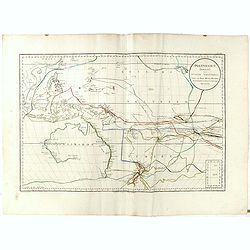
A Map of the Discoveries made by Capt. Cook & Clerke in the Years 1778 & 1779 between the Eastern Coast of Asia and the Western Coast of North America. . .
An early American map showing Cook's explorations of Hawaii and Alaska, published in one of the first atlas of America printed in America. "Engraved for Cary's Ameri...
Date: Philadelphia, 1795
Selling price: ????
Please login to see price!
Sold in 2019
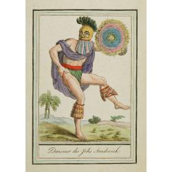
Danseur des Isles Sandwich.
Hand-colored mezzotints of Native Americans drawn by Labrousse and engraved by Laroque after Jacques Grasset de Saint-Sauveur.
Date: Paris,1796
Selling price: ????
Please login to see price!
Sold in 2010
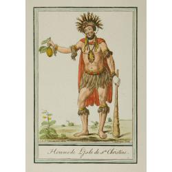
Homme de l'Isle de Ste Christine.
Hand-colored mezzotints of Native Americans drawn by Labrousse and engraved by Laroque after Jacques Grasset de Saint-Sauveur.
Date: Paris,1796
Selling price: ????
Please login to see price!
Sold in 2010
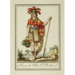
Femme de l'Isle Ste Christine.
Hand-colored mezzotints of Native Americans drawn by Labrousse and engraved by Laroque after Jacques Grasset de Saint-Sauveur.
Date: Paris,1796
Selling price: ????
Please login to see price!
Sold in 2010
Partie de la Mer du Sud comprise entre les Philippines et la Californie d'apres de Carte Espagnole trouvee sur le Galion pris par l'Amiral Anson en 1743. . .
Two large sea charts on one sheet. Each from the Philippines to California one of the route of the Spanish galleons from Manilla to Acapulco with recent discoveries, and ...
Date: Paris, 1797
Selling price: ????
Please login to see price!
Sold in 2019
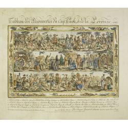
Tableau des Decouvertes du Cap.ne Cook, & de la Pérouse.
Three series of figures of natives with key below, surrounded by narrow pictorial border. The print is in original state, as issued, never folded into a book and never in...
Date: Paris, 1798
Selling price: ????
Please login to see price!
Sold in 2021
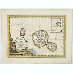
L'Isola O-Taiti scoperta dal Cap. Cook, con le Marchesi di Mendoza.
This an example of Cassini's wonderful map made in order to celebrate the visit to Tahiti by the English Captain James Cook, during his scientific mission to observe the ...
Date: Rome, 1798
Selling price: ????
Please login to see price!
Sold in 2020
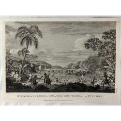
Massacre of De Langle, Lemanon & Ten Others of the Two Crews.
Engraved battle scene with native Samoans using rocks with slings and clubs. Published in London by G.G. & J. Robinson in 1799. Engraved by Neele. Jean-Francois de Ga...
Date: London, 1799
Selling price: ????
Please login to see price!
Sold in 2018
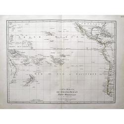
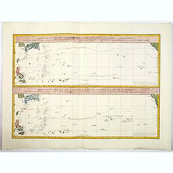
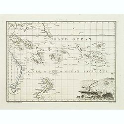
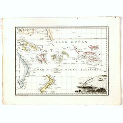
Carte reduite du Grand Ocean partie meridionale.
Scarce map of the South Pacific by Poirson. Shows Australia (Nouvelle Hollande) with unfinished coast line. Includes New Zealand, Hawaii, and large parts of the Americas....
Date: Paris, 1802
Selling price: ????
Please login to see price!
Sold in 2013
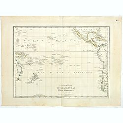
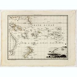
Carte reduite du Grand Océan partie Mériodionale. (Page XXV)
Detailed map of the Pacific giving good detail on Americas west coast. Including New Zealand and eastern part of Australia.Jean Baptiste Poirson (1760-1831) was a French ...
Date: Paris, 1802
Selling price: ????
Please login to see price!
Sold in 2023
Kaart van de Societeit Eilanden.
Captain James Cook (1728-79), explorer, circumnavigator and hydrographer. Three voyages, 1768-71, 1772-75 and 1776-79. From 1778 on printed editions of ' Captain Cook's T...
Date: Leiden, 1795-1803
Selling price: ????
Please login to see price!
Sold
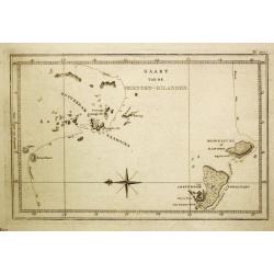
Kaart van de Vrienden-Eilanden.
Captain James Cook (1728-79), explorer, circumnavigator and hydrographer. Three voyages, 1768-71, 1772-75 and 1776-79. From 1778 on printed editions of ' Captain Cook's T...
Date: Leiden, 1795-1803
Selling price: ????
Please login to see price!
Sold in 2008
Gezicht van Huaheine.
Captain James Cook (1728-79), explorer, circumnavigator and hydrographer. Three voyages, 1768-71, 1772-75 and 1776-79. From 1778 on printed editions of ' Captain Cook's T...
Date: Leiden, 1795-1803
Selling price: ????
Please login to see price!
Sold in 2008
Kaart van het Eiland Otahiti.
Captain James Cook (1728-79), explorer, circumnavigator and hydrographer. Three voyages, 1768-71, 1772-75 and 1776-79. From 1778 on printed editions of ' Captain Cook's T...
Date: Leiden, 1795-1803
Selling price: ????
Please login to see price!
Sold in 2008
Oude Gedenktekenen op het Paasch-Eiland.
Captain James Cook (1728-79), explorer, circumnavigator and hydrographer. Three voyages, 1768-71, 1772-75 and 1776-79. From 1778 on printed editions of \' Captain Cook\'s...
Date: Leiden, 1795-1803
Selling price: ????
Please login to see price!
Sold in 2009
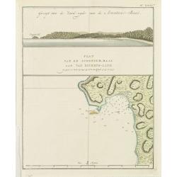
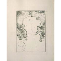
Gezicht van de Zuidzijde van de Avontur-Baai/ Plan van de Avontuur-Baai aan van Diemens-Land.
Captain James Cook (1728-79), explorer, circumnavigator and hydrographer. Three voyages, 1768-71, 1772-75 and 1776-79. From 1778 on printed editions of ' Captain Cook's T...
Date: Leiden, 1795-1803
Selling price: ????
Please login to see price!
Sold in 2009
General charte von Australien Nachdem neusten Entdeckungs Reisen..
Map of Australia, the S.W. Pacific, and Indonesia showing Australia lettered Neu Holland vormals Ulimaroa with separated Tasmania.
Date: Weimar, 1803
Selling price: ????
Please login to see price!
Sold
Landing op het eiland Tanna, een van de Nieuwe Hebriden.
Captain James Cook (1728-79), explorer, circumnavigator and hydrographer. Three voyages, 1768-71, 1772-75 and 1776-79. From 1778 on printed editions of Captain Cooks Trav...
Date: Leiden, 1795-1803
Selling price: ????
Please login to see price!
Sold in 2008
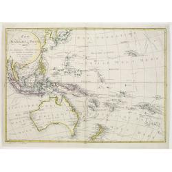
Carte Reduite de la Mer des Indes et de la Partie Occidentale du Gran Ocean. 1803.
An important chart of the south seas, showing Australia with the discoveries made by James Cook on the east coast, and Nicholas Baudin, also including current knowledge o...
Date: Paris, 1803
Selling price: ????
Please login to see price!
Sold in 2021
Generalcharte von Australien nach dem Entwurfe des K.Joseph Marx Freiherrn v. Lichtenstein. . .
The map features the islands of the Pacific and Australia which is named "Neu Holland vormals Ulimaroa" on its western half and in the eastern half "Neu S�...
Date: Vienna, Kunst- und Industrie-Comptoirs, 1805
Selling price: ????
Please login to see price!
Sold in 2022
Die Nordküste von Bas's Strasse aufgenomen.
Map of the south east coast of Australia, with the northern tip of van Diemens land. According to the title cartouche the map was drawn by Lieuth. Jac Grant in December 1...
Date: Weimar 1807
Selling price: ????
Please login to see price!
Sold
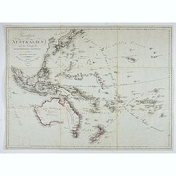
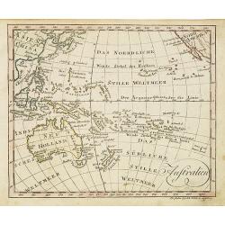
Australien nach den neuesten astronomischen Bestimmungen und Entdeckungs-Reisen
Scarce Austrian map of Australia and Oceania. Published in this state only in "Lehrbuch der Geographie". Large and detailed map, filled with numerous place name...
Date: Vienna, ca. 1810
Selling price: ????
Please login to see price!
Sold in 2008
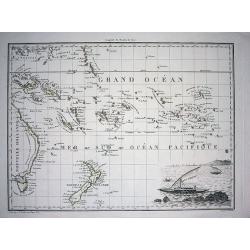
Océanique Orientale.
Interesting map showing the area from the Carolines to Tahiti and the Pitcairn Island, also New Zealand, and Australia from Torres Strait to Tasmania. Engraved by J.B.Tar...
Date: Paris, c1810
Selling price: ????
Please login to see price!
Sold in 2010
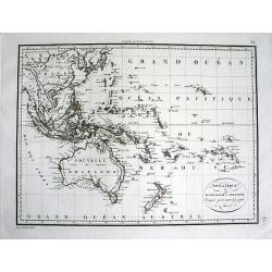
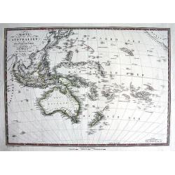
Océanie ou Australasie et Polynesie.
Detailed map of South-East Asia, Indonesia, Australia, parts of the South Pacific, and New Zealand. Includes also Japan and the Philippines A rare edition of this detail...
Date: Paris, 1810
Selling price: ????
Please login to see price!
Sold in 2011
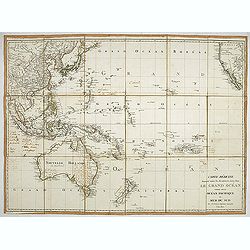
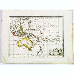
Carte réduite donnant toutes les découvertes faites dans le grand océan. . .
A fine map of the Pacific Ocean, published in Paris by Poirson. The map shows Australia with the complete coastline and "Terre Bonaparte" four years before the ...
Date: Paris 1810
Selling price: ????
Please login to see price!
Sold in 2021
Australia.
Nice small map centered on Australia and New Zealand published by Johannes Walch in his rare Allgemeiner Atlas Nach den bewährsten Hülfsmitteln und astronomischen Ortsb...
Date: Augsburg, 1812
Selling price: ????
Please login to see price!
Sold in 2016
Océanique orient.
In lower right hand corner a view of sailor. An steel engraved map showing part of the east coast of Australia with Torres Strait to Tasmania., the Marquesas, the Carolin...
Date: Paris, 1812
Selling price: ????
Please login to see price!
Sold in 2022
Océanique orient.
In lower right hand corner a view of sailor. An steel engraved map showing part of the east coast of Australia with Torres Strait to Tasmania., the Marquesas, the Carolin...
Date: Paris, 1812
Selling price: ????
Please login to see price!
Sold in 2015
Océanique orient.
In lower right hand corner a view of sailor. An steel engraved map showing part of the east coast of Australia with Torres Strait to Tasmania., the Marquesas, the Carolin...
Date: Paris, 1812
Selling price: ????
Please login to see price!
Sold in 2016
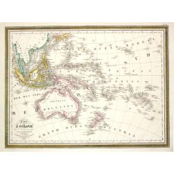
Oceanique.
A map covering Australia, New Zealand, the Pacific Islands ,South East Asia, and part of China. A small decorative title cartouche is seen in the lower right corner. From...
Date: Paris, 1812
Selling price: ????
Please login to see price!
Sold in 2017
Oceanique.
A map covering Australia, New Zealand, the Pacific Islands ,South East Asia, and part of China. A small decorative title cartouche is seen in the lower right corner. From...
Date: Paris, 1812
Selling price: ????
Please login to see price!
Sold in 2018
Océanique orient.
In lower right hand corner a vignette view of Pacific sailing craft. A nice steel engraved map showing part of the east coast of Australia from the Torres Strait to Tasma...
Date: Paris, 1812
Selling price: ????
Please login to see price!
Sold in 2017
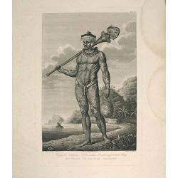
Plate of a tattooed male from Nukuhiva (Marquesas Islands)
An original plate in imperial folio size, originating from Krusenstern's 1813-14 atlas (Russian & German language) to his voyage around the world: Atlas k puteshestvi...
Date: St. Petersburg, 1813-1814
Selling price: ????
Please login to see price!
Sold in 2011
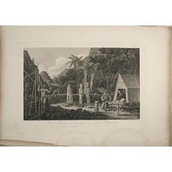
Plate of a Moray on Nukuhiva (Marquesas Islands).
An original plate in imperial folio size, originating from Krusenstern's 1813-14 atlas (Russian & German language) to his voyage around the world: Atlas k puteshestvi...
Date: st. Petersburg, 1813-1814
Selling price: ????
Please login to see price!
Sold in 2011
Map of Port Anna Maria (Taiohae Bay) at Nukuhiva, Marquesas Islands.
An original map in imperial folio size with wide margins, originating from Krusenstern's 1813-14 atlas (Russian & German language) to his voyage around the world: Atl...
Date: St. Petersburg, 1813-1814
Selling price: ????
Please login to see price!
Sold in 2011
![Nouvelle-Hollande - Vases, Armes, Pêche. [plate XXII]](/uploads/cache/46344-250x250.jpg)
Nouvelle-Hollande - Vases, Armes, Pêche. [plate XXII]
Set of weapons and fishing tools by Lesueur, from Voyage de découvertes aux terres Australes by François Péron, 1824.The French expedition under Nicolas Baudin, was co...
Date: Paris, 1807-1816
Selling price: ????
Please login to see price!
Sold in 2022
![Nouvelle-Hollande: Ile King. - Le Wonbat [plate XXVIII]](/uploads/cache/46350-250x250.jpg)
Nouvelle-Hollande: Ile King. - Le Wonbat [plate XXVIII]
Plate illustrating Wobat by Lesueur, from Voyage de découvertes aux terres Australes by François Péron, 1824.The French expedition under Nicolas Baudin, was commission...
Date: Paris, 1807-1816
Selling price: ????
Please login to see price!
Sold in 2020
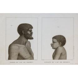
Homme du Cap de Diemen , Enfant du Cap de Diemen
Print taken from the "Atlas pour servir a la relation du voyage a la recherche de la Perouse" published by Dabo.
Date: Paris, 1817
Selling price: ????
Please login to see price!
Sold in 2010

Femme du Cap de Diemen.
Print taken from the "Atlas pour servir a la relation du voyage a la recherche de la Perouse" published by Dabo.
Date: Paris, 1817
Selling price: ????
Please login to see price!
Sold in 2010
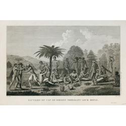
Sauvages du Cap de Diemen préparant leur repas.
Print taken from the "Atlas pour servir a la relation du voyage a la recherche de la Perouse" published by Dabo.
Date: Paris, 1817
Selling price: ????
Please login to see price!
Sold in 2010
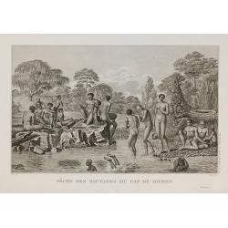
Pêche des sauvages du Cap de Diemen.
Print taken from the "Atlas pour servir a la relation du voyage a la recherche de la Perouse" published by Dabo.
Date: Paris, 1817
Selling price: ????
Please login to see price!
Sold in 2010
Islands in the Pacific Ocean, drawn & engraved for Dr. Playfairs Atlas.
A detailed steel engraved map of the South Pacific, from Australia to Hawaii, including the Marquesas and the Society Islands (French Polynesia). Many even smaller island...
Date: London, 1821
Selling price: ????
Please login to see price!
Sold in 2018
Karte von Australien oder der fünfte Welttheil.
RARE map of Indonesia, Australia, and the South Pacific! Engraved by Rudolph von Rothenburg, and published by Artaria. Large and very detailed map including many even sm...
Date: Vienna, 1822
Selling price: ????
Please login to see price!
Sold in 2011
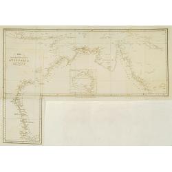
Chart of the intertropical & west coasts of AUSTRALIA as surveyed in the years 1818 to 1822..
Fine detailed map of the north and west coast of Australia and Indonesia. Engraved by J.Walker and published by John Murray.With inset map of the continent of Australia.
Date: London 1825
Selling price: ????
Please login to see price!
Sold
Carte de L\'Oceanie. Paris, 1824.
Louis Vivien de Saint Vivien. French cartographer. Atlas Universal, 1825.A map of the Pacific.
Date: Paris, 1825
Selling price: ????
Please login to see price!
Sold in 2017
![[Lot of 3 maps] Partie de la Nouvelle Guinée No 22+23+31](/uploads/cache/97401-250x250.jpg)
[Lot of 3 maps] Partie de la Nouvelle Guinée No 22+23+31
A set of three highly detailed and important map of New Guinea. With extensive descriptive text in French. With original hand-coloring.Vandermaelen accomplished the first...
Date: Brussels, 1825
Selling price: ????
Please login to see price!
Sold in 2016
