Browse Listings in Asia > South East Asia
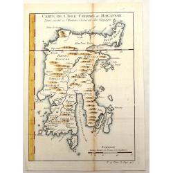
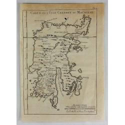
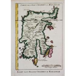
Carte de L'Isle Celebes ou Macassar.
Fine little copper engraved map of Celebes Island, Makassar (Buginese-Makassar language:– sometimes spelled Macassar, Mangkasara) – It is the provincial capital of So...
Place & Date: Paris, 1750
Selling price: $90
Sold in 2015
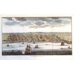
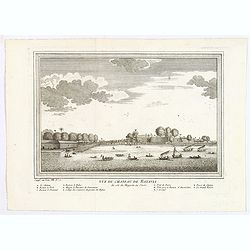
Samboupo.
Detailed view of Samboupo on the island of Celebes (Sulawesi) Indonesia. Over one dozen ships are sailing in the harbour and river. By Jacob van der Schley in 1750.
Place & Date: Paris, 1750
Selling price: $30
Sold in 2019
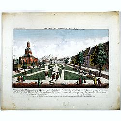
Prospect des Rathhauses in Batavia wie dasselbige auf dem grossen Platz nebst der um liegende Gegend (von fornen anzusehen).
A view of present-day Fatahillah Square in Jakarta. In the middle of the print the Raadhuis , headquarters of the VOC -nowadays the Jakarta museum-is clearly visible.
Place & Date: Augsburg, 1750
Selling price: $250
Sold in 2016
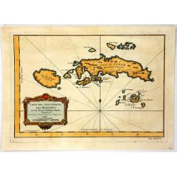
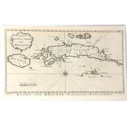
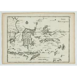
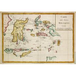
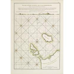
Carte des Isles Voisines Des Moluques
An old antique cartographic map of the Molucas Isles in Indonesia, including Ceram - Bouro Amboine - Banda – Neyra, by Bellin from Abbe A.F. Prévost’s, “Histoire G...
Place & Date: Paris, 1750
Selling price: $65
Sold in 2016
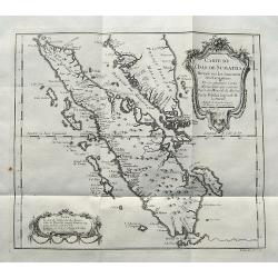
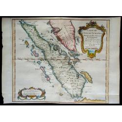
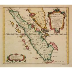
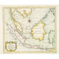
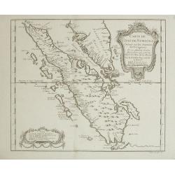
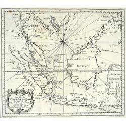
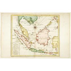
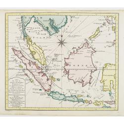
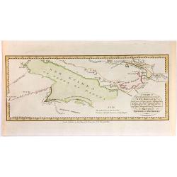
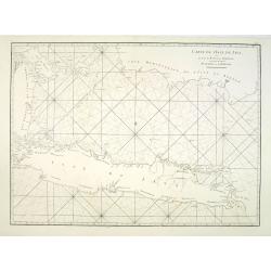
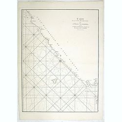
Carte de L'Isle de Sumatra...
A detailed map of Sumatra and parts of the Malay Peninsula with the Straits of Singapore. Many towns, islands, and rivers are named.Decorated with a large title cartouche...
Place & Date: Paris, ca 1750
Selling price: $50
Sold in 2017
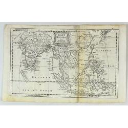
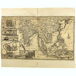
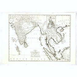
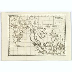
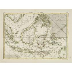
East Indies.
A fine map of the East Indies, bounded by China in the northeast, the Timors and New Guinea in the Southeast, India and the Maldives in the Southwest and Tibet and the Mo...
Place & Date: London, ca. 1750
Selling price: $37
Sold in 2017
Carte de L'Isle Celebes ou Macassar.
A fine copper engraved map of Celebes Island. It is the provincial capital of South Sulawesi, Indonesia. It is the largest city on Sulawesi Island in terms of population ...
Place & Date: Paris, 1750
Selling price: $15
Sold in 2018
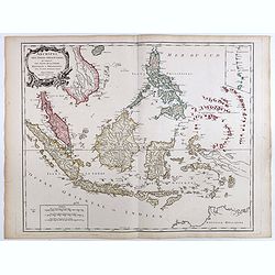
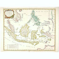
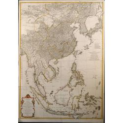
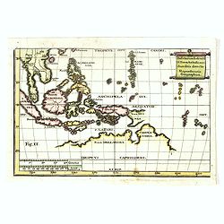
Archipel Des Indes Orientales, qui comprend Les Isles De La Sonde.. Philippines..
An attractive and detailed view of the Indonesian islands in large format and Malacca and Southern China to the Philippines, New Guinea and Northern Australia. Includes a...
Place & Date: Paris, 1750
Selling price: $500
Sold in 2018
Charte von Ost-Indien und den Angraentzenden Laendern'... 'Geographi Mr. Herman Moll ... Durch M. Georg. Christian Bohnstedt Rector an der Dom-Schule zu Halberst. . .1737
Rare German map showing the area from India to Japan, and south to include the East Indies. The map is filled with information on political divisions, towns, and roads. T...
Place & Date: Lepzig, ca. 1750
Selling price: $2500
Sold in 2020
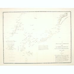
Carte de l'Isle de Sumatra....
Map of Sumatra, also showing the tip of the Malay Peninsula and the Straits of Singapore. An unusually detailed map of the area, showing many coastal features, shoals, ba...
Place & Date: Paris, 1750
Selling price: $45
Sold in 2018
Archipel Des Indes Orientales, qui comprend Les Isles De La Sonde.. Philippines..
An attractive and detailed view of the Indonesian islands in large format. Decorative title cartouche.
Place & Date: Paris, 1750
Selling price: $150
Sold in 2021
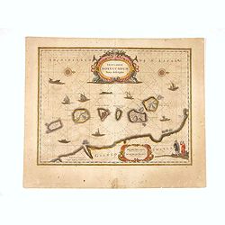
Insularum Moluccarum ..
Exquisite map of the famous Spice Islands based on the islands described by Jan Huyghen van Linschoten. This map was the first large scale map of the region and depicts t...
Place & Date: Amsterdam, 1750
Selling price: $100
Sold in 2020
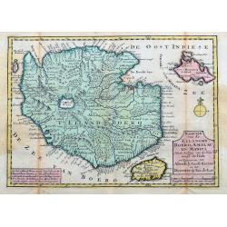
Kaartje van de Eilanden Boero, Amblau en Manipa...
Scarce map of Buru in the Maluku Islands of Indonesia which was part of the VOC - Dutch East India Company. Also showing the islands Ambelau and Manipa. One of the most d...
Place & Date: Deventer, c1750
Manuscript map in brown ink showing the island Ternate centered on Gamalama (and fort Malayu.
Detailed German manuscript map with part of the island Ternate showing in great detail the main harbor town of the island Gamalama and the nearby fortress Maleyo. The isl...
Place & Date: ca. 1750
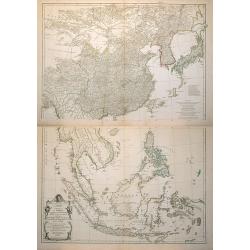
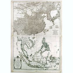
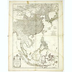
Seconde partie de la carte d'Asie contenant la Chine et partie de la Tartarie, l'Inde ... Sumatra, Java, Borneo, Moluques, Philippines et du Japon
Attractive large map of Asia from G. de la Haye by J.B.B. d'Anville. Showing southeast Asia with Japan and Korea. Printed on two plates, joined.
Place & Date: Paris, 1752
Selling price: $900
Sold in 2009
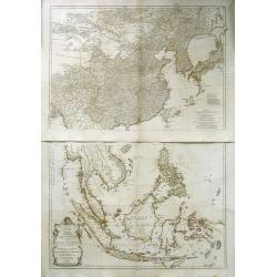
Seconde partie de la carte d\'Asie contenant la Chine et partie de la Tratarie, l\'Inde ... Sumatra, Java, Borneo, Moluques, Philippines et du Japon
Attractive large map of Asia from G. de la Haye by J.B.B. d\'Anville. Showing south east Asia with Japan and Korea. Printed on two plates
Place & Date: Paris, 1752
Selling price: $600
Sold in 2008
Seconde partie de la carte d'Asie contenant la Chine et partie de la Tratarie, l'Inde . . . Sumatra, Java, Borneo, Moluques, Philippines et du Japon.
An attractive large map of Asia from G. de la Haye by J.B.B. d'Anville. Showing south east Asia with Japan and Korea. Printed on two plates.
Place & Date: Paris, 1752
Selling price: $780
Sold in 2010
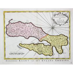
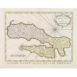
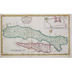
Carte Particuliere de L'Isle d'Amboine.
Fine hand-colored,copper engraved map of Ambon in the Moluccas Islands (Spice Islands)off the coast of Indonesia. After N. Bellin and engraved by Van Schley.
Place & Date: Paris, 1752
Selling price: $69
Sold in 2018
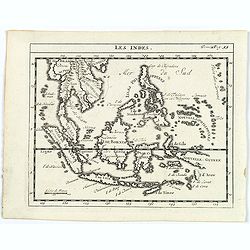
Les Indes.
A scarce small map of South East Asia with Indonesia, Thailand, Philippines and including New Guinee.
Place & Date: Paris, ca. 1752
Selling price: $55
Sold in 2017
Seconde partie de la carte d'Asie contenant la Chine et partie de la Tartarie, l'Inde au-delà du Gange, les Isles Sumatra, Java, Borneo, Molusques, Philippines et du Japon.
Two-sheet map of South East Asia with very good detail of Philippines. Containing China and part of Tartary, India beyond the Ganges, Sumatra Isles, Java, Borneo, Molucca...
Place & Date: Paris, 1752
Selling price: $1000
Sold in 2023
Seconde partie de la carte d'Asie contenant la Chine et partie de la Tartarie, l'Inde au-delà du Gange, les Isles Sumatra, Java, Borneo, Molusques, Philippines et du Japon.
A wall map size map of South East Asia with very good detail of Philippines. Containing China and part of Tartary, India beyond the Ganges, Sumatra Isles, Java, Borneo, M...
Place & Date: Paris, 1752
Selling price: $500
Sold in 2018
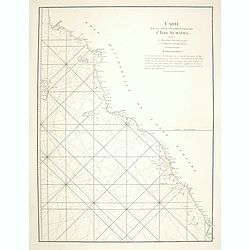
Vlakke hoek van Sumatra.
Showing the part of the west coast of Sumatra with the island of Enggano. Very rare: included in 6th volume, so-called secret atlas of the V.O.C. of Van Keulen. Latitude ...
Place & Date: Amsterdam 1753
Selling price: $475
Sold
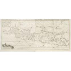
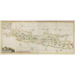
Insulae Iava Pars Occidentalis Edente Hadriano Relando..
Rare first state of this finely engraved and detailed map of Java important for its Dutch trading connections - annotated panels, clearly indicated rice fields, mountains...
Place & Date: Amsterdam 1753
Selling price: $3000
Sold
Zee-Caart van het Eyland Sumatra Met de Straaten Malacca, Sincapoera, Banca en Sunda..
A rare and finely engraved and detailed chart of Sumatra important for its Dutch trading connections. In upper right corner a detailed depiction of southern tip of Malays...
Place & Date: Amsterdam 1753
Selling price: $4900
Sold
Insulae Java Pars Occidentalis Edente Hadriano Relando. . .
Very rare first state of this finely engraved and detailed map of Java important for its Dutch trading connections - annotated panels, clearly indicated rice fields, moun...
Place & Date: Amsterdam, 1753
Selling price: $5200
Sold in 2009
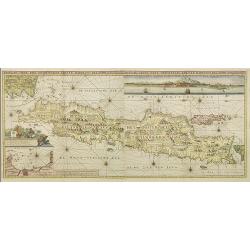
Insulae Java Pars Occidentalis Edente Hadriano Relando. . .
Second state of this finely engraved and detailed chart of Java important for its Dutch trading connections - annotated panels, clearly indicated rice fields, mountains, ...
Place & Date: Amsterdam, 1753
Selling price: $7000
Sold
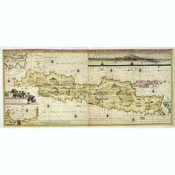
Insulae Java Pars Occidentalis Edente Hadriano Relando. . .
Second state of this finely engraved and detailed chart of Java important for its Dutch trading connections - annotated panels, clearly indicated rice fields, mountains, ...
Place & Date: Amsterdam, ca. 1753
Selling price: $2800
Sold in 2018
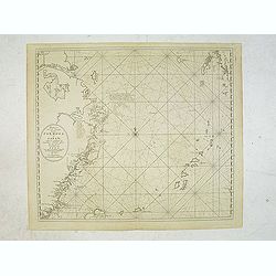
Pas-Kaaart van de Haven van Nangasequi.
A rare and finely engraved and detailed chart of Nagasaki.Latitude scale, compass rose and system of rhumb lines, soundings, anchorage's, etc.Very rare: only included in ...
Place & Date: Amsterdam, 1753
Selling price: $5500
Sold
Carte des isles voisines des Moluques
A striking antique map of the Ceram, Ambon and the Banda islands close to Indonesia. Published by Antonine de Prevost d' Exile's “Histoire Generale des Voyages”. (Fro...
Place & Date: Amsterdam, 1754
Selling price: $34
Sold in 2019
A Map of the East Indies from the latest Authorities and Observations....
Uncommon detailed map of South East Asia, India, and part of China, extending to Tibet, the Maladies, Sumatra, part of Borneo, Hainan, Kanton, etc.In upper right inset of...
Place & Date: London, 1754
Selling price: $300
Sold in 2017
Carte Particulare de l' Isle d' Amboine.
Jaques Nicolas Bellin (1702-720) was the most important French hydrographer of the 18th century. Sea-atlas 'Hydrographique Français' , 1756-65, atlas to accompany Prévo...
Place & Date: Amsterdam, c. 1755
Selling price: $100
Sold in 2009
Carte d L' Isle de Sumatra.
Jaques Nicolas Bellin (1702-720) was the most important French hydrographer of the 18th century. Sea-atlas 'Hydrographique Français' , 1756-65, atlas to accompany Prévo...
Place & Date: Paris, c. 1755
Selling price: $240
Sold in 2008
Isles Moluques.
A scarce little map depicting European knowledge of Sulawesi, part of Borneo and the Spice Islands at the time of publication.George Louis Le Rouge was active from 1740- ...
Place & Date: Paris, 1756
Selling price: $90
Sold in 2009
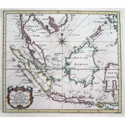
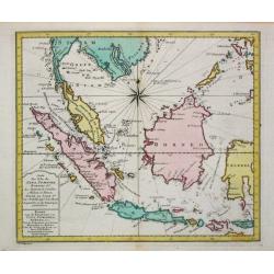
Carte des Isles de Java Sumatra et Borneo..
A very fine map centered on the islands of Java, Sumatra, Borneo and Malay Peninsular.Jacques Nicolaas Bellin (1703-1772) was one of the most important and proficient Fre...
Place & Date: Paris 1757
Selling price: $100
Sold
Carte Des Isles De Java, Sumatra, Borneo &c Les Detroits de la Sonde Malaca et Banca Golphe De Siam...
Detailed map of Southeast Asia, with the Gulf of Siam, Cambodia, Brunei, Mindoro in the Philippines, Lombok, Bali, Java and Sumatra, Borneo and the Malay Peninsula.A deco...
Place & Date: Paris, 1757
Selling price: $180
Sold in 2016
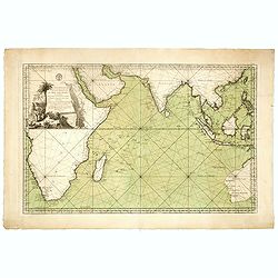
Jacques Nicolas Bellin: Carte Reduite De L'Ocean Oriental ou Mer Des Indes Seconde Edition Pour Servir aux Vaisseau du Roy . . . Par order de M. De. Machault . . . MDCC LVII
This map is a second state of Bellin's map of the Indian Ocean and is significantly revised from the first edition of 1740. Significant revisions are shown in Australia a...
Place & Date: Paris, 1757
Selling price: $1300
Sold in 2018
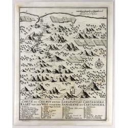
Carte du Chemin Entre Samarang et Cartasoera.
A highly detailed 1757 Bellin map depicting the Road between Semarang and Kartasuro in Java, Indonesia. Semarang is the capital and largest city of Central Java province ...
Place & Date: Paris, 1757
Selling price: $24
Sold in 2019
Carte de l'Isle de Sumatra Dréssée sur les Journaux des Navigateurs...
Map of Sumatra, also showing the tip of the Malay Peninsula and the Straits of Singapore. An unusually detailed map of the area, showing many coastal features, shoals, ba...
Place & Date: Paris, 1758
Selling price: $140
Sold in 2008
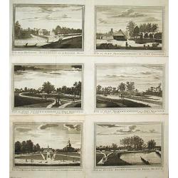
Vue de la Maison de Ville á Batavia / Vue de la Batterie Anjol / Vue du Fort Noortwyck en venant de Ryswyck / Vue du Fort noortwyck en venant de Jacatra / Vue de Poste Ryswyck / Vue du Fort Tangeran.
Jan van Schley is the engraver of the maps (by J.N. Bellin) and views in the Dutch edition of A.F. Prévost d\' Exile\'s \'Histoire Géneral des Voyages.A set of 6 engrav...
Place & Date: Amsterdam, 1759
Selling price: $350
Sold
Kaart van 't Eiland Celebes of Makassar.
Jaques Nicolas Bellin (1702-720) was the most important French hydrographer of the 18th century. Sea-atlas 'Hydrographique Français' , 1756-65, atlas to accompany Prévo...
Place & Date: Amsterdam, c. 1760
Selling price: $60
Sold
CARTE DES ISLES DE JAVA, SUMATRA, BORNEO & LES DETROITS DE LA SONDE MALACA ET BANCA GOLPHE DE SIAM ETC
Very detailed map of Indonesia by celebrated French mapmaker Nicolas Bellin. Decorated with a compass rose and an attractive title cartouche. Many Islands and harbors are...
Place & Date: Paris, c1760
Selling price: $80
Sold
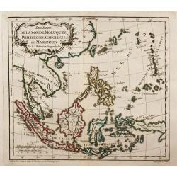
Les Isles de la Sonde, Moluques, Philippines, Carolines, et Mariannes.
Small detailed map of southeast Asia, showing the Malay Peninsula, Sumatra, Java and the island of Borneo.
Place & Date: Paris, 1762
Selling price: $110
Sold in 2010
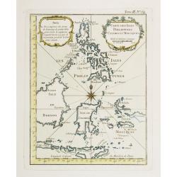
Carte Des Isles Philippines Celebes et Moluques.
Attractive map of the region showing the islands of the Philippines, Suluwesi, the Moloccus, Timor, Flores, Bali, and parts of Borneo and Java. There is no interior detai...
Place & Date: Paris 1764
Selling price: $80
Sold
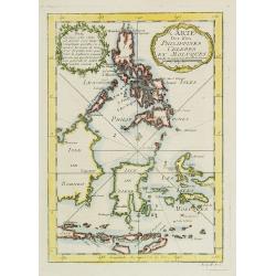
Carte Des Isles Philippines Celebes et Moluques.
Attractive map of the region showing the islands of the Philippines, Sulawesi, the Moluccas, Timor, Flores, Bali, and parts of Borneo and Java. There is no interior detai...
Place & Date: Paris, 1764
Selling price: $80
Sold in 2009
Vue du Chateau de Batavia.
A nice view of Batavia (now Jakarta in Indonesia) then under the control of the Dutch VOC. Many vessels are seen off the harbor, beneath the print is a lettered legend (A...
Place & Date: Paris, ca 1764
Selling price: $65
Sold in 2020
Les Indies Orientales pour la Concorde de la Geographie. . .
A nice small map of India and South East Asia, from the "Concorde de la Geographie des Differens Ages" by Freres Estienne.
Place & Date: Paris, 1765
Selling price: $55
Sold in 2020
A particular plan of Acheen road with the islands adjacent. . .
Uncommon English of part of the most northern part of Sumatra, with the ancient Sultanate of Acheen.William Herbert (1718-1795), was born 29 Nov. 1718, and was educated ...
Place & Date: London, 1767
Selling price: $150
Sold in 2011
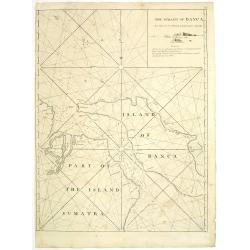
The straits of Banca. . .
Uncommon English with the Straits of Banca in northern part of Sumatra, with inset map in top right corner.William Herbert (1718-1795), was born 29 Nov. 1718, and was ed...
Place & Date: London, 1767
Selling price: $150
Sold in 2011
Insularum Indicaru & Terrae Australis necdum fatis derectae Repraesentatio Geographica.
The map shows whole South-East Asia with partial Australia which only on the north-west coast was discovered.Read more Early maps of South East Asia [+]
Place & Date: 1770
Selling price: $400
Sold in 2021
Indes IVe Feulle
A detailed map showing Indonesia, Philippines and New Guinea.
Place & Date: Paris, 1771
Selling price: $250
Sold in 2019
![[4 sheet map] Carte Hydro-geo-graphique des Indes Orientales . . .](/uploads/cache/41388-250x250.jpg)
[4 sheet map] Carte Hydro-geo-graphique des Indes Orientales . . .
A detailed map with a large, decorative title cartouche, showing from India east to the Philippines, Borneo, Java, the Celebes, and Timor and Formosa. Marked across areas...
Place & Date: Paris, 1771
Selling price: $550
Sold in 2020
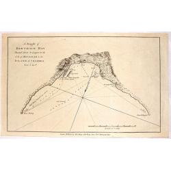
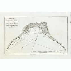
A Draught of Bonthain Bay Situated About 30 Leagues to the S.E. of Macassar in the Island of Celebes.
Interesting copper engraved nautical chart featuring the Bantaeng Region of Indonesia.< Relief shown pictorially and by hachures with depths by soundings.
Place & Date: London, 1772
Selling price: $11
Sold in 2016
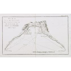
A Draught of Bonthain Bay.
A fine map of Bonthian Bay on the Island of Sulawesi, in Indonesia. The bay is about 30 leagues to the southeast of Macassar.
Place & Date: Paris, 1772
Selling price: $4
Sold in 2015
Carte des Isles de Java Sumatra et Borneo..
A very fine map centered on the islands of Java, Sumatra, Borneo and Malay Peninsular.With French text in title cartouche and an additional title in Dutch below.
Place & Date: Amsterdam 1773
Selling price: $360
Sold
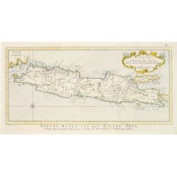
Nouvelle carte de l'Isle de Java.
A very nice map centered on the island of Java.With French text in title cartouche and an additional title in Dutch underneath the map.
Place & Date: Amsterdam 1773
Selling price: $200
Sold
Carte des Isles de Java, Sumatra Borneo & Les Détroits de la Sonde Malaca et Banca Golphe de Siam.
Jaques Nicolas Bellin (1702-720) was the most important French hydrographer of the 18th century. Sea-atlas 'Hydrographique Français' , 1756-65, atlas to accompany Prévo...
Place & Date: Amsterdam, 1773
Selling price: $250
Sold in 2016
Carte Particuliére de L'Isle d'Amboine.
Uncommon edition of this detailed close-up of this Indonesian island Ambon, only infrequently encountered in this manner.With a pleasing title cartouche and 10. engraved ...
Place & Date: Amsterdam, 1773
Selling price: $50
Sold in 2013
Carte des Isles de Java Sumatra et Borneo..
A very fine map centered on the islands of Java, Sumatra, Borneo and Malay Peninsular.From Atlas Portatif pour servir a l'intelligence de l'Histoire Philosophique et Poli...
Place & Date: Amsterdam, 1773
Selling price: $250
Sold in 2012
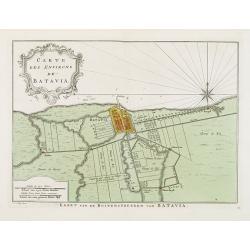
Carte Des Environs de Batavia.
Uncommon edition of this fine plan of Batavia, head quarters of the V.O.C. In lower right engraved 13.From Atlas Portatif pour servir a l'intelligence de l'Histoire Philo...
Place & Date: Amsterdam, 1773
Selling price: $250
Sold in 2013
4 Nautical Charts in One - Matavia Bay in Otaheite etc.
This striking map is made up of four nautical charts including: - Matavia Bay in Otaheite, - Ohamaneno Harbour in Ulietea, - Owharre Harbour in Houheine & - Oopoah Ha...
Place & Date: London, 1773
Selling price: $16
Sold in 2020
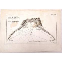
A Draught of Bonthain Bay situated about 30 Leagues to the S E of Macassar in the Island of Celebes. . .
Bonthain Bay at the island of Sulawesi [i.e. Celebes]. The bay is about 30 leagues to the southeast of Macassar. Large amount of detail in the bay including the location ...
Place & Date: London, W. Strahan and T. Cadell, 1773
Selling price: $20
Sold in 2022
A Chart of Captain Carteret's Discoveries at New Britain, with Part of Captain Cook's Passage Thro Endeavour Streights, & of Captain Dampier's Tract & Discoveries in 1699, & 1700, at New Guinea & New Britain
This fine chart of Papua New Guinea shows the new discoveries of Captains Cook, Carteret, and Dampier along New Guinea, New Britain, and New Ireland. The chart details th...
Place & Date: London, 1773
Selling price: $34
Sold in 2018
Carte des Isles Moluques.
Rigobert Bonne (1727-1795), French cartographer. His maps are found in a.o. Atlas Moderne (1762), Raynal's Histoire Philos. du Commerce des Indes (1774) and Atlas Encyclo...
Place & Date: Paris, 1774
Selling price: $155
Sold in 2009
Vue de la Baye de Bonthain . . .dans l\'Isle des Celebes. Tome I Pl. 16.
Chart of Bonthain Bay on the Island of Celebes. This map is taken from the first French edition of James Cook\'s first voyage entitled Relation des voyages entrepris par ...
Place & Date: Paris, 1774
Selling price: $50
Sold in 2008
Kaart van 't Eyland Amboine.
An uncommon map of the island of Ambon.
Place & Date: Almelo, 1775
Selling price: $90
Sold in 2009
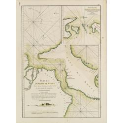
Carte Plate de la partie Septentrionale du Détroit de Malac depuis la Rade d'Achem jusqu'à Malac.
French of the Island of Sumatra and the Malay Peninsula separated by the strait of Malacca in Indonesia. Latitude and longitude scales, compass rose and system of rhumb ...
Place & Date: Paris, ca 1775
Selling price: $300
Sold
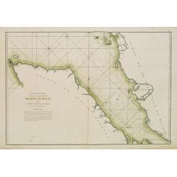
Carte Plate de la Côte Occidentale de l'Isle de Sumatra?
French chart of the north west coast of the island of Sumatra.Latitude and longitude scales, compass rose and system of rhumb lines, soundings near coast and in bay areas...
Place & Date: Paris, ca 1775
Selling price: $160
Sold
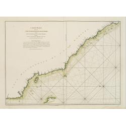
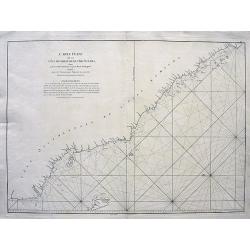
Carte de la Côte occidentale de l'Isle de Sumatra. . .
French of the lower west coast of Sumatra. Latitude and longitude scales, compass rose and system of rhumb lines, soundings near coast and in bay areas.D' Après de Mann...
Place & Date: Paris, ca 1775
Selling price: $160
Sold
Carte du Détroit de la Sonde depuis la Pointe de winerou jusqu'à l'Isle du Nord.Plan de la Baye de l'Ile de Mew ou Cantaye?
French chart of Sunda Street with the southeast cost of Sumatra and the western tip of Java.Latitude and longitude scales, compass rose and system of rhumb lines, soundin...
Place & Date: Paris, ca 1775
Selling price: $400
Sold in 2008

Carte de l\'Isle de Java avec les Isles de Banca, de Biliton, et une partie de cellesd de Sumatra et de Bornéo.
French chart of the Island of Java, Banca, Billiton, and part of Sumatra and Borneo.Latitude and longitude scales, compass rose and system of rhumb lines, soundings near ...
Place & Date: Paris, ca 1775
Selling price: $400
Sold in 2008
Carte pour aller du Détroit de la Sonde ou de Batavia au Détroit de Banca.
French of the coast of East Sumatra and North-West part of Java. With inset chart Plan des Isles Remouw, Kandang, High et Voody, situées au Sud-Est de l'Isle de Sumatra...
Place & Date: Paris, ca 1775
Selling price: $175
Sold in 2019
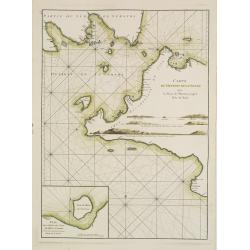
Plan du Détroit de Banca.. / Petit plan du Détroit à l'Est de Banca.
French detailed of the straits between Sumatra and Bangka. With inset : Petit plan du Détroit à l'Est de Banca.. The chart is an updated version of an earlier copper p...
Place & Date: Paris, ca 1775
Selling price: $150
Sold in 2019
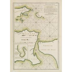
Nouveau Plan des Détroits, situés à l'Est de Java et de Madura, nommmés communément les Détroits de Bali et d'entre Pondi et Respondi..
French chart of straits of Bali. With eastern tip of Java, part of Madura and western tip of Bali. Inset chart of harbour of Ballembouang. The chart is giving credit to t...
Place & Date: Paris, ca 1775
Selling price: $190
Sold
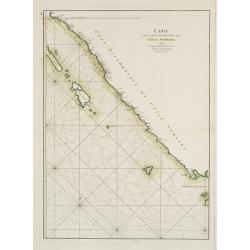
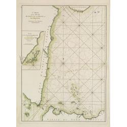
Carte Plate de la Cote Occidentale de l'Isle Sumatra depuis la Riviere de Touroumane jusqu'a la Pointe d'Indrapour...
Highly detailed and large sea-chart showing a part of the Sumatran westcoast. With numerous depth soundings and anchor places, showing even the smallest shoals, to help n...
Place & Date: Paris, c1775
Selling price: $200
Sold in 2008
Plan de la Rade d'Achem et des Isles Circonvoisines Situées à la partie Nord-ouest de Sumatra.
French large nautical of the Archem coast on the northwestern point of Sumatra.Latitude and longitude scales, compass rose and system of rhumb lines, soundings near coas...
Place & Date: Paris, Brest, chez Demonville, 1775
Selling price: $100
Sold in 2019
Carte de l'Isle de Java avec les Isles de Banca, de Biliton, et une partie de cellesd de Sumatra et de Bornéo.
French of the Island of Java, Banca, Billiton, and part of Sumatra and Borneo.Latitude and longitude scales, compass rose and system of rhumb lines, soundings near coast...
Place & Date: Paris, Brest, chez Demonville, 1775
Selling price: $180
Sold in 2013
A Mar of part of Borneo and the Sooloo Archipelago: Laid down chiefly from observations made in 1761, 2,3, and 4.
Most important milestone based upon the surveys made from navigational surveys in 1761-64 by Alexander Dalrymple (1737-1808]. He was the first hydrographer of the Britis...
Place & Date: Paris, ca 1775
Selling price: $105
Sold in 2014
Carte de la Côte occidentale de l\'Isle de Sumatra. . .
French of the lower west coast of Sumatra. Latitude and longitude scales, compass rose and system of rhumb lines, soundings near coast and in bay areas.D' Après de Mann...
Place & Date: Paris, Brest, chez Demonville, 1775
Selling price: $35
Sold in 2014
Carte de la côte occidentale de l\'isle Sumatra depuis la ligne équinoctiale jusqu\'au détroit de la Sonde
French of the east coast of Sumatra.Latitude and longitude scales, compass rose and system of rhumb lines, soundings near coast and in bay areas.D' Après de Mannevillet...
Place & Date: Paris, Brest, chez Demonville, 1775
Selling price: $40
Sold in 2014
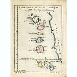
Carte Particuliere Des Isles Moluques. . .
A small interesting map of the islands of Herij, Pottebackers, Ternate, Tidor, Timor, Machian and Bachian. Today the Moluccas are part of Indonesia.Prepared by Jacques Ni...
Place & Date: Paris, 1738-1775
Selling price: $20
Sold in 2014