Browse Listings in Asia > Holy Land & Jerusalem
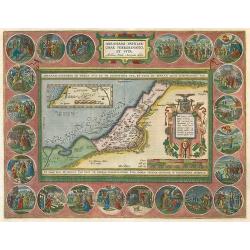
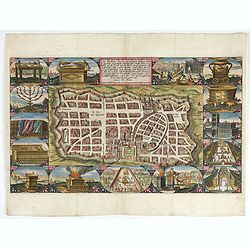
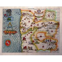
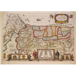
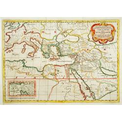
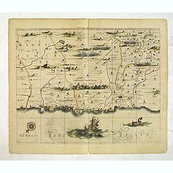
Abrahami Patriarchae Peregrinatio, et Vita.
The most beautiful "carte à figures" map from Ortelius' Theatri Orbis Terrarum Parergon. The medallions illustrate the life of Abraham. Latin text on verso.
Date: Antwerp, 1624
Selling price: ????
Please login to see price!
Sold in 2009
![[Closeup plan of the structure of a tabernacle].](/uploads/cache/26465-250x250.jpg)
[Closeup plan of the structure of a tabernacle].
Plan of the structure of a tabernacle. In the foreground you have the gate which leads you in the outer court to the brazen altar behind which we find the laver before en...
Date: Holland, ca. 1625
Selling price: ????
Please login to see price!
Sold in 2010
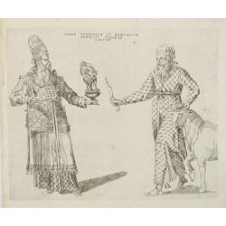
Sacer Pontificum et Sacerdotum Aronici Ordinis Haitus.
Copper engraved print depicting a ceremony by a high priest. From an uncommon edition of Kerckelycke Historie van Neder-Landt which was a Dutch text edition of Agostino T...
Date: Holland, ca. 1625
Selling price: ????
Please login to see price!
Sold in 2010
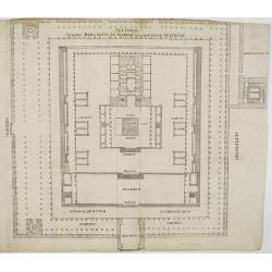
![Salomonis templi Vestigium. [Salomon's temple]](/uploads/cache/26450-250x250.jpg)
Salomonis templi Vestigium. [Salomon's temple]
Plan of Salomon's Temple. From an uncommon edition of Kerckelycke Historie van Neder-Landt which was a Dutch text edition of Agostino Torniello's Annales Sacri et Profani...
Date: Holland, ca. 1625
Selling price: ????
Please login to see price!
Sold in 2009
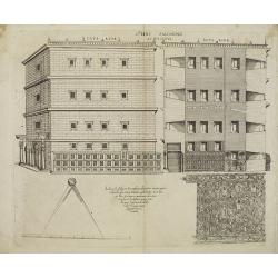
Occidens Templi Herodiani ex Iosephi Descriptione vesticium.
Plan of Herod's Temple in Jerusalem, which was a massive expansion of the Temple Mount and construction of a completely new and much larger Jewish Temple by King Herod th...
Date: Holland, ca. 1625
Selling price: ????
Please login to see price!
Sold in 2010
Templi Salomonis.
Engraving of the Temple of Solomon. From an uncommon edition of Kerckelycke Historie van Neder-Landt which was a Dutch text edition of Agostino Torniello's Annales Sacri ...
Date: Holland, ca. 1625
Selling price: ????
Please login to see price!
Sold in 2010
![[Various ritual objects].](/uploads/cache/26461-250x250.jpg)
[Various ritual objects].
Various ritual objects such as the candelabrum. From an uncommon edition of Kerckelycke Historie van Neder-Landt which was a Dutch text edition of Agostino Torniello's An...
Date: Holland, ca. 1625
Selling price: ????
Please login to see price!
Sold in 2010
![[Altar of Burnt Offerings].](/uploads/cache/26462-250x250.jpg)
[Altar of Burnt Offerings].
Altar of Burnt Offerings or also called the Brazen Altar. From an uncommon edition of Kerckelycke Historie van Neder-Landt which was a Dutch text edition of Agostino Torn...
Date: Holland, ca. 1625
Selling price: ????
Please login to see price!
Sold in 2010
![[Salamon muro ab ima Valle erecto montis vierticem Templi area coaqual].](/uploads/cache/26463-250x250.jpg)
[Salamon muro ab ima Valle erecto montis vierticem Templi area coaqual].
Engraving showing the construction of the wall of Salamon's Templel. From an uncommon edition of Kerckelycke Historie van Neder-Landt which was a Dutch text edition of Ag...
Date: Holland, ca. 1625
Selling price: ????
Please login to see price!
Sold in 2010
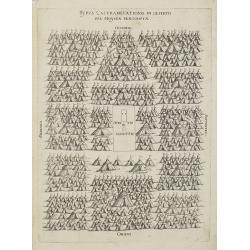
Typus Castrametationis in deserto per moysen praescriptae.
A campment with its tents of Moses and Aron among others. In center "Atrium Sanctum". From an uncommon edition of Kerckelycke Historie van Neder-Landt which was...
Date: Holland, ca. 1625
Selling price: ????
Please login to see price!
Sold in 2010
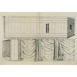
Exterior Tabernaculi eiusqtabularum vectium ac basium aspectus / Coverings of the tabernacle.
Closeup of the coverings of a tabernacle. Starting from left to right : curtains of fine linen, curtains of goat's hair, ram's skin dyed red, outer covering of badger's s...
Date: Holland, ca. 1625
Selling price: ????
Please login to see price!
Sold in 2015
![[Altaris uncensi / the incense altar].](/uploads/cache/26470-250x250.jpg)
[Altaris uncensi / the incense altar].
Engraving depicting an Incense Altar, used to purify a room.From an uncommon edition of Kerckelycke Historie van Neder-Landt which was a Dutch text edition of Agostino To...
Date: Holland, ca. 1625
Selling price: ????
Please login to see price!
Sold in 2016
![[Atrii Sancti ac Tabernaculi Foederisorthographia].](/uploads/cache/26473-250x250.jpg)
[Atrii Sancti ac Tabernaculi Foederisorthographia].
Military campment with its tabernacle moving forward. The Tabernacle (small tent which contained the most holy writings of the ancient Jews) is being carried towards a ne...
Date: Holland, ca. 1625
Selling price: ????
Please login to see price!
Sold in 2011
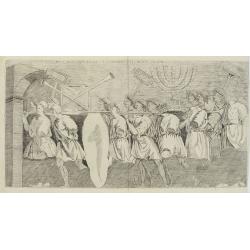
Sacra Iudaeorum spolia in triumpho titi romam delata.
Triumphal procession of men holding on their shoulders various pieces of Tabernacle furniture : the Brazen Altar, the Candlestick, and the Golden Altar. From an uncommon ...
Date: Holland, ca. 1625
Selling price: ????
Please login to see price!
Sold in 2015
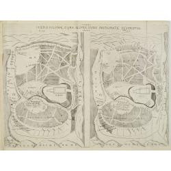
Hierosolymae, cura Neemiae ducis Instauratae Descriptio.
Two plans of Jerusalem, left according to Brocadus (Burchardus de Monte Sion), and right after Villalpando. The plans are very similar. From an uncommon edition of Kercke...
Date: Holland, ca. 1625
Selling price: ????
Please login to see price!
Sold in 2008
![Tabula XXXXII Mansinum Populi Israelitici in Deserto. [ the flight into Egypt ]](/uploads/cache/26448-250x250.jpg)
Tabula XXXXII Mansinum Populi Israelitici in Deserto. [ the flight into Egypt ]
Map of the Holy Land showing the flight into Egypt. From an uncommon edition of Kerckelycke Historie van Neder-Landt which was a Dutch text edition of Agostino Torniello'...
Date: Holland, ca. 1625
Selling price: ????
Please login to see price!
Sold in 2008
Terrae Chanaan inter XII Tribuus Isrel Distributae Orthographia.
Map of the Holy. From an uncommon edition of Kerckelycke Historie van Neder-Landt which was a Dutch text edition of Agostino Torniello's Annales Sacri et Profani by Herib...
Date: Holland, ca. 1625
Selling price: ????
Please login to see price!
Sold in 2008
![[Two Brazen Lavers].](/uploads/cache/26471-250x250.jpg)
[Two Brazen Lavers].
Detailed description two Brazen Lavers. The laver was a great bowl or basin of polished brass, thus giving the effect of a mirror. From an uncommon edition of Kerckelyck...
Date: Holland, ca. 1625
Selling price: ????
Please login to see price!
Sold in 2016
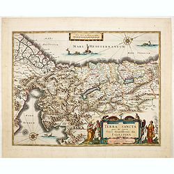
Terra Sancta..
A finely detailed copperplate engraving with north on the left. From Latin text version of Atlas Minor.
Date: Amsterdam 1628
Selling price: ????
Please login to see price!
Sold
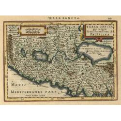
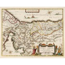
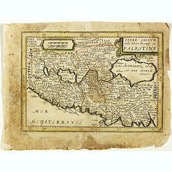
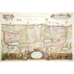
Terra Sancta que in Sacris Terra Promissionis ol: Palestina
A complete map of the Holy Land. In the upper right corner we find a nicely decorated title cartouche, on the upper left side is a scale bars. A attractive map which incl...
Date: Amsterdam, 1630
Selling price: ????
Please login to see price!
Sold in 2009
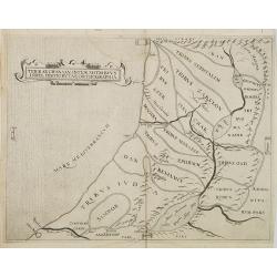
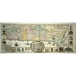
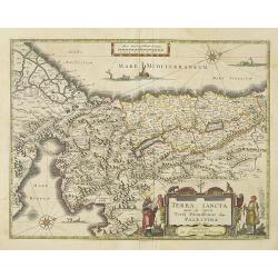
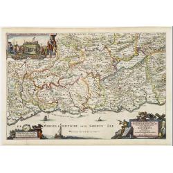
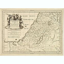
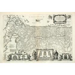
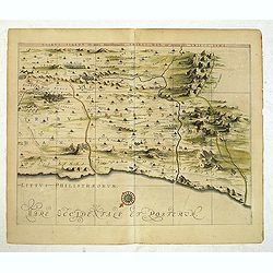
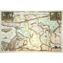
Chorographia Terrae Sanctae in Angustiorem formam Redacta et ex Variis Auctoribus a Multis Erroribus Expurgata.
A highly attractive and large map of the Holy Land, printed from two plates joined. The map ranges from Syria and Tyre southward as far as the Sinai, Egypt and Thebes. Th...
Date: Antwerp, 1632
Selling price: ????
Please login to see price!
Sold in 2021
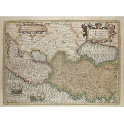
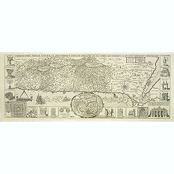
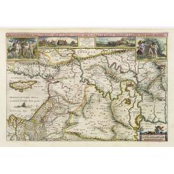
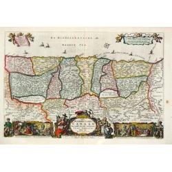
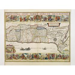
Chorographia Terrae Sanctae in Angustiorem Forman Redacta..
Large map of the Holy Land surrounded with panels of vignettes displaying sacred objects including a menorah, the arc of the covenant, the altar of sacrifices, the Tabern...
Date: Antwerp 1632
Selling price: ????
Please login to see price!
Sold
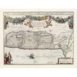
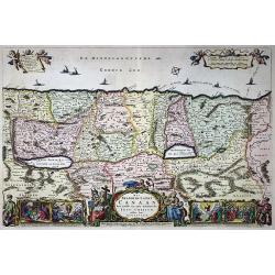
Situs Terrae Promissionis.S.S.Bibliorum intelligentiam..
Superb map of the Holy Land, after Adrichom, with north oriented to the left. It is finely engraved with numerous biblical scenes including the Exodus, the wandering of t...
Date: Amsterdam, 1633
Selling price: ????
Please login to see price!
Sold in 2020

TERRA SANCTA quae in Sacris Terra Promissionis olim PALESTINA.
One of the most decorative Holy Land maps of the period. This map of the Holy Land depicts the tribes of Israel, and the route the children of Israel took from Egypt thro...
Date: Amsterdam, 1634
Selling price: ????
Please login to see price!
Sold in 2016
Terra Sancta quae in Sacris Terra Promissionis..
Very decorative map of Palestine. Orientated west to the top. The decoration is inspired by the Old Testament. Moses stands to the left of the title cartouche, Aaron to t...
Date: Amsterdam 1635
Selling price: ????
Please login to see price!
Sold
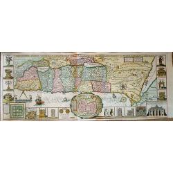
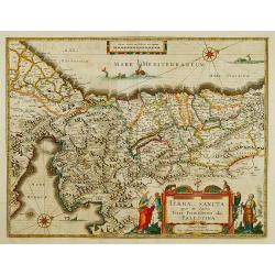
Chorographia Terrae Sanctae in Angustiorem formam Redacta et ex Variis Auctoribus a Multis Erroribus Expurgata . . .
Large attractive plan of the Holy Land in east orientation. First published in Antwerp 1632. Centered a city plan of Jerusalem after Villalpando 'Hierosolymae Veteris Ima...
Date: Antwerp, 1638
Selling price: ????
Please login to see price!
Sold in 2013
Terra Sancta quae in Sacris Terra Promissionis..
Very decorative map of Palestine. Orientated west to the top. The decoration is inspired by the Old Testament. Moses stands to the left of the title cartouche, Aaron to t...
Date: Amsterdam, 1638
Selling price: ????
Please login to see price!
Sold in 2013
TERRA SANCTA quae in Sacris Terra Promissionis?
The Holy Land, Promised Land or Palestine. Oriented to the west. Shows the entire Palestine on both sides of the Jordan, the shore line running from Tripoli as far as the...
Date: Amsterdam 1640
Selling price: ????
Please login to see price!
Sold
De gelegenheyt van t'paradys ende t'landt van Canaan. . .
Very attractive map, showing the location of Paradise. Two vignettes depict the Temptation of Adam and Eve, and their Expulsion from the Garden of Eden.
Date: Amsterdam, 1642
Selling price: ????
Please login to see price!
Sold in 2017
Tabula Geographica, in qua regiones Cananaeae, et locorum situs. . .
This is the second state of the Petrus Plancius bible map. D.R.M. Mathes , whose identity we don't really know (Doctor Rudolf Mercator, Mathematicus ??), made minimal cha...
Date: Amsterdam, 1643
Selling price: ????
Please login to see price!
Sold in 2010
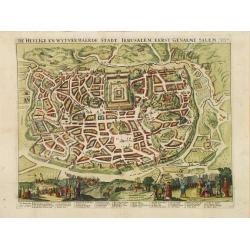
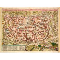
Waerachtige beschryvinge vande wydvermaerde Conincklicke Hooft Stadt Jerusalem.
Engraved by Baptista van Doetechum for a bible printed by Jan Everts Cloppenburg. The bible maps of 1590 are the earliest of Plancius compilations to survive.Very rare pl...
Date: Amsterdam, 1643
Selling price: ????
Please login to see price!
Sold in 2022
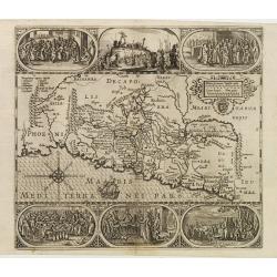
Palestinae sive Terrae Sanctae quae et Promissionis Nova Tabula ad SS. Bibliorum Intelligentiam Delineata ex Christiano Adrichomio collecta
A uncommon map of the Holy Land, based on Christian von Adrichem's two-sheet map of 1590. This map shows the shoreline from Sidon to Alexandria, and includes the mouth of...
Date: Paris, 1646
Selling price: ????
Please login to see price!
Sold in 2010
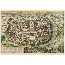
De heylige en wytvermaerde stadt Jerusalem.
Imaginary plan of ancient Jerusalem with all the principal sites numbered and keyed to a table at bottom. Shows the city with the Second Temple and Herrod's Castle and th...
Date: Amsterdam 1646
Selling price: ????
Please login to see price!
Sold
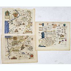
![[ Lot of 3 items of the Holy Land] Perigrinatie ofte Veertich-jarige Reyse, Der Kinderen Israels.](/uploads/cache/86347-250x250.jpg)
[ Lot of 3 items of the Holy Land] Perigrinatie ofte Veertich-jarige Reyse, Der Kinderen Israels.
The rare ' Wandering Children Israel ' map by Jacob Savry from a Dutch bible. Right bottom 3 vignettes with the Camp Israel, Vessels of the Temple and a priest. Above the...
Date: Amsterdam, 1647
Selling price: ????
Please login to see price!
Sold in 2023
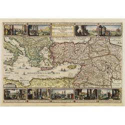
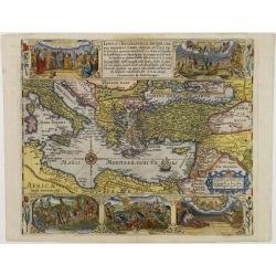
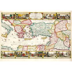
Geographische beschryvinge van de Wandeling der apostelen ende reysen van Pauli.
Finely engraved detailed map covering the whole of the eastern Mediterranean. Showing the travels of the apostles after the death of Christ, with episodes from the life o...
Date: Amsterdam 1648
Selling price: ????
Please login to see price!
Sold
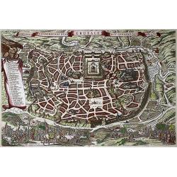
De Heylige en Wytvermaerde Stadt Ierusalem Eerst Genaemt Salem
Very attractive bird's-eye view of Jerusalem, showing the city laid out in blocks with 36 important buildings identified by name through a key index. In the foreground ar...
Date: Amsterdam 1648
Selling price: ????
Please login to see price!
Sold
Geographische beschryvinge van de Wandeling der Apostelen ende de Reysen van Pauli.
Finely engraved detailed "carte à figures"- map covering the whole of the eastern Mediterranean. Showing the travels of the apostles after the death of Christ, ...
Date: Amsterdam, 1648
Selling price: ????
Please login to see price!
Sold
Geographische beschrijvinge van 'T Beloofde-Landt Canaan..
Fine map of Israel with north oriented to the left. Decorative title cartouche at bottom and an inset picture of the crucifixion in the left top corner. Tiny ships sail i...
Date: Amsterdam, 1648
Selling price: ????
Please login to see price!
Sold
De Gelegentheyt van 't Paradys Ende 't Landt Canaan..
Uncommon issue of this very attractive map, showing the location of Paradise. Two vignettes depict the Temptation of Adam and Eve, and their Expulsion from the Garden of ...
Date: Amsterdam, 1648
Selling price: ????
Please login to see price!
Sold in 2008
Geographische Beschryvinge van t'Beloofde-Landt Canaan, door Wandelt van onsen Heere ende Salichmaecker Iesu Christo nessens syne Apostelen van nieus gecorigeert ende seer verbetert door Iacob Savery Ao 1648
Fine Bible map of the Holy Land by or after Visscher. Highly detailed with numerous place names, rivers, mountains, and regions. The sea is filled with fishing boats, th...
Date: Amsterdam, 1648
Selling price: ????
Please login to see price!
Sold in 2014
Perigrinatie ofte Veertich-jarige Reyse der Kinderen Israels.
Dutch so-called "Staten-bibles," published between 1637 and c. 1760, contained five maps: The World, "Paradise," The Peregrinations, The Promised Land...
Date: Dordrecht, 1648
Selling price: ????
Please login to see price!
Sold in 2019
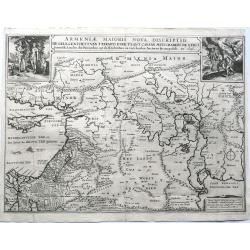
A set of four Dancker Danckerts Bible maps
The following set of highly decorative and scarce Danckerts maps is offered here: 1. The map depicting the location of Paradise. Title: ARMENIAE MAIORIS NOVA ...
Date: Amsterdam, 1650
Selling price: ????
Please login to see price!
Sold in 2023
No title. Map of the Holy Land.
Engraved by Baptista van Doetechum for a bible by Plancius.The rare re-issue by Joost Hartgers. The bible maps of Plancius came into the hands of the Amsterdam publisher ...
Date: Amsterdam 1650
Selling price: ????
Please login to see price!
Sold
DAN Holy Land by Thomas Fuller.
An scarce and altogether fascinating 1650 map of The tribes of Israel by Thomas Fuller. The map is centered on Bethlehem with Ekron to the west and Lydda to the north, Co...
Date: John Williams, London 1650
Selling price: ????
Please login to see price!
Sold in 2012
Confinia Palestinea cum incolis ad Orientem (together with 2 other maps)
Together three decorative copper engraved maps taken from Thomas Fuller, "A Pisgah sight of Palestine" and etched by Vaughan. Engraved by John Golddard. and Tho...
Date: London, 1650
Selling price: ????
Please login to see price!
Sold in 2013
Tabula Geographica in qua omnes regiones, urbes..
Engraved by Baptista van Doetechum for a bible by Plancius.The rare re-issue by Joost Hartgers. The bible maps of Plancius came into the hands of the Amsterdam publisher ...
Date: Amsterdam 1650
Selling price: ????
Please login to see price!
Sold in 2009
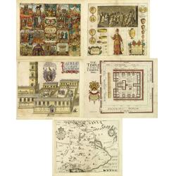
Pantheon sive Idola Judeorum. (together with) Atria Templi Solomonis (together with 4 other maps)
Together five decorative copper engraved plates or map taken from Thomas Fuller, "A Pisgah sight of Palestine" and etched by Vaughan.1./ Pantheon sive Idola Jud...
Date: London, 1650
Selling price: ????
Please login to see price!
Sold in 2012
Nova descriptio Judae ae et totius terrae Israel as illustrrationem. . .
Unrecorded map of the Holy Land engraved by Nicolas Berey II.
Date: Paris, ca. 1650
Selling price: ????
Please login to see price!
Sold
Palestinae sive terrae Sanctae quae et promissionis nova..
Map of the Holy Land, unfortunately with a teared lower corner.Nicolas Sanson was to bring about the rise of French cartography, although the fierce competition of the Du...
Date: Paris, 1652
Selling price: ????
Please login to see price!
Sold in 2014
Het Beloofde Landt Canaan door wandelt van onsen Salichmaecker Iesus Christo, neffens syne Apostelen
A decorative map depicting the Holy Land with 4 scenes from the life of Christus, 3 cartouches and two fisherman. Claes Jansz. Visscher (1587-1652). The Dutch so-called '...
Date: Amsterdam, 1657
Selling price: ????
Please login to see price!
Sold in 2021
Perigrinatie ofte Veertich-Jarige Reyse der Kinderen..
Finely engraved and detailed. Showing the dispersion of the tribes of Israel. With an inset showing the actual lay out of the camp of the Israelis According to the law of...
Date: Amsterdam, Nic. Visscher, c. 1657
Selling price: ????
Please login to see price!
Sold in 2009
Perigrinatie ofte Veertich-jarige Reyse der Kinderen Israels.
Dutch so-called ' Staten' bibles, published between 1637 and c. 1760, contained 5 maps: The World, ' Paradise', The Perigrinations, The Promised Land Canaan, The Travels ...
Date: Amsterdam, Nic. Visscher, c. 1657
Selling price: ????
Please login to see price!
Sold
Peregrinatie ofte Veertich-jarige Reyse der Kinderen Israels.
Claes Jansz. Visscher (1587-1652), founder of the publishing house
Date: Amsterdam, 1657
Selling price: ????
Please login to see price!
Sold
Het Beloofde Landt Canaan door wandelt van onsen Salichmaecker Iesus Christo, neffens syne Apostelen
Claes Jansz. Visscher (1587-1652), founder of the publishing house
Date: Amsterdam, 1657
Selling price: ????
Please login to see price!
Sold
Het Beloofde Landt Canaan door wandelt van onsen Salichmaecker Iesu Christo, neffens syne Apostelen.
Showing the travels of Christ and His disciples. With 36 numbered sites and insets of the Birth, Resurrection, Ascension and Pentecost. Orientated with east to the top.
Date: Amsterdam, 1657
Selling price: ????
Please login to see price!
Sold in 2020
Geographishe Beschryvinghe van de Wandeling der Apostelen ende de Reysen Pauli . . . door Nicolaes Visscher.
Claes Jansz. Visscher (1587-1652), founder of the publishing house.
Date: Amsterdam, 1657
Selling price: ????
Please login to see price!
Sold
De Heylige en Wytvermaerde stadt Ierusalem Eerst Genaemt Salem, Genesis 14 vers 18
Bird's eye plan of the holy city of Jerusalem with 36 principal sites numbered and keyed to a table in a scroll at left, which is held aloft by an eagle. Biblical scenes ...
Date: Amsterdam, 1657
Selling price: ????
Please login to see price!
Sold in 2020
Terra Sancta quae in Sacris Terra Promissionis. . .
Very decorative map of Palestine. Orientated west to the top. The decoration is inspired by the Old Testament. Moses stands to the left of the title cartouche, Aaron to t...
Date: Amsterdam, 1658
Selling price: ????
Please login to see price!
Sold in 2015
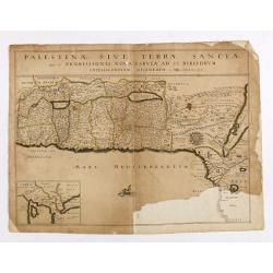
Palestina, Sive Terrae Sanctae Descriptio.
Oriented to the east, divided into the Tribes on both sides of the Jordan, the shoreline from Sidon to Alexandria. Along the top and the bottom 18 vignettes showing the E...
Date: Amsterdam 1658
Selling price: ????
Please login to see price!
Sold
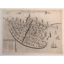
Civitas Acon Sive Ptolomaida.
A very rare plan of Acre, one of the oldest continuously inhabited cities in the world. It shows extensive fortifications, town plan, buildings and a key identifying sign...
Date: Paris, 1658
Selling price: ????
Please login to see price!
Sold in 2023
Terra Sancta sive Promissionis, olim Palestina..
Apparently this same plate was used by later cartographers, such as De Wit. The top portion with cartouche was taken from a John Speed map of the Holy Lands.
Date: Amsterdam, 1659
Selling price: ????
Please login to see price!
Sold in 2023
Tabula Itineraria Patriarcharum Abrahami, Isaaci et Jacobi.
The Holy Land and Egypt in left hand part of the map. Showing travels of Abraham, Isaac and Jacob. With some nice decorative cartouches.
Date: Amsterdam, 1660
Selling price: ????
Please login to see price!
Sold in 2017
Totius Terrae Sanctae Delineatio.
Rare map of Palestine with large decorative title cartouche, from a book by Cluver Introductionis in Universam Geograpicam published by Johannis Bunonis.
Date: Wolfenbüttel 1661
Selling price: ????
Please login to see price!
Sold
GEOGRAPHIAE SACRAE ex Veteri? TABULA PRIMA?
Map of the world according to the Sacred Geography, showing most of the Mediterranean and of the Middle East. Chanaan is shown before the conquest by the Jews. Inset: Isr...
Date: Paris 1662
Selling price: ????
Please login to see price!
Sold
![[Hornius Map of the Holy Land, Israel, and Palestine]](/uploads/cache/44765-250x250.jpg)
[Hornius Map of the Holy Land, Israel, and Palestine]
A fine example of a single sheet from the original six sheet map by Georgius Hornius map of the Holy Land. The map is embellished with countless vignettes and other image...
Date: Amsterdam, Janssonius, 1662
Selling price: ????
Please login to see price!
Sold in 2020
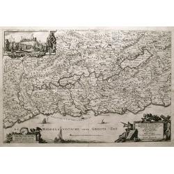
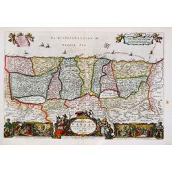
Tribus Aser, et partes occidentales tribuum Zabulon et Isachar.
One sheet of the six sheet map by Georgius Hornius map of the Holy Land. Each of the maps is embellished with countless vignettes and other images drawn from Biblical tra...
Date: Amsterdam, Janssonius, 1662
Selling price: ????
Please login to see price!
Sold in 2014
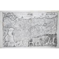
Dimidia Tribus Manasse Ultra Iordanem, Tribus Neptalim et partes orientales tribuum Zabulon et Isachar.
One sheet of the six sheet map by Georgius Hornius map of the Holy Land. Each of the maps is embellished with countless vignettes and other images drawn from Biblical tra...
Date: Amsterdam, Janssonius, 1662
Selling price: ????
Please login to see price!
Sold in 2013
Terre Sainte jadis Terre Promise ou Palestine. (18).
Scarce map of Palestine published by Antoine de Fer in 1661 or 1662 in "Cartes de géographie revues et augmentées". With number 18 in lower right bottom of the ...
Date: Paris, Antoine de Fer, 1657 but 1661 or 1662
Selling price: ????
Please login to see price!
Sold in 2021
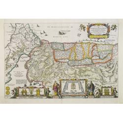
Tribuum Ephraim, Beniamin, et Dimidiae Manasse intra Iordanem partes occidentales, et partes septentrionales Dan et Iuda.
One sheet of the six sheet map by Georgius Hornius map of the Holy Land. Each of the maps is embellished with countless vignettes and other images drawn from Biblical tra...
Date: Amsterdam, Janssonius, 1662
Selling price: ????
Please login to see price!
Sold in 2013
De Heylige en wyt vermaerde stadt Jerusalem eerst genaemt Salem.
Joshua Offerman's plan of Jerusalem is a close copy of the second state of the plan by Claes Jansz Visscher. The fisherman above the legende bottom left has been substitu...
Date: Gorkum, 1662
Selling price: ????
Please login to see price!
Sold
Tribus Simeon et pars meridionalis Tribus Dan, et orientalis Tribus Idua.
One sheet of the six sheet map by Georgius Hornius map of the Holy Land. Each of the maps is embellished with countless vignettes and other images drawn from Biblical tra...
Date: Amsterdam, Janssonius, 1662
Selling price: ????
Please login to see price!
Sold in 2014
Hornius Map of the Holy Land, Israel, and Palestine.
A fine example of the six sheet map by Georgius Hornius map of the Holy Land. Each of the maps is embellished with countless vignettes and other images drawn from Biblica...
Date: Amsterdam, Janssonius, 1662
Selling price: ????
Please login to see price!
Sold in 2018
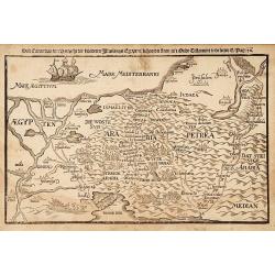
Deze Caerte van den Uittocht der kinderen Israels..
Rare wood block map, depicting the exodus from Egypt, from the final Dutch edition of Heinrich B¨nting's famous Itinerarium Sacrae Scripturae, a book mainly about...
Date: Amsterdam 1663
Selling price: ????
Please login to see price!
Sold
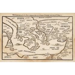
Deze Caerte van de henzen pauli..
Rare wood block map, depicting the Mediterranean, from the final Dutch edition of Heinrich Bünting's famous Itinerarium Sacrae Scripturae, a book mainly about th...
Date: Amsterdam 1663
Selling price: ????
Please login to see price!
Sold
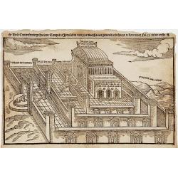
Dese Conterfentinge hoe den Tempel te Jerusalem
Rare wood block print, depicting the Solomon's Temple, from the final Dutch edition of Heinrich Bünting's famous Itinerarium Sacrae Scripturae, a book mainly about the Ho...
Date: Amsterdam 1663
Selling price: ????
Please login to see price!
Sold
Het Beloofde Landt Canaan..
Title of the map: "Het Beloofde Landt Canaan door wandelt van onsen Salichmaecker Iesu Christo, neffens syne Apostelen"Fine map of Israel with north oriented to...
Date: Amsterdam 1663
Selling price: ????
Please login to see price!
Sold
De gelegentheyt van 't paradys..
Dutch Bible map covering the region between the Mediterranean and the Persian Gulf, featuring the Garden of Eden. Strapwork title cartouche flanked by scenes of Eve offer...
Date: Amsterdam 1663
Selling price: ????
Please login to see price!
Sold
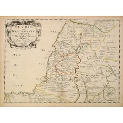
Sourie ou Terre Saincte moderne..
Decorative and detailed map of modern Palestine. Shows the political division under Turkish rule. Prepared by Philippe de La Rue. In lower right hand corner inset sketch ...
Date: Paris, 1663
Selling price: ????
Please login to see price!
Sold in 2013
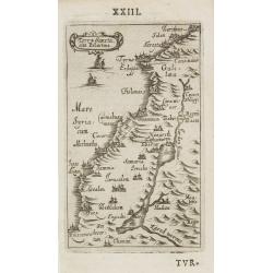
Terra Sancta sine Palestina.
Charming little map of the Holy Land made by Gabriel Bucelin (1599-1681). Bucelin was a Swiss genealogist and an author of several books and a number of manuscript maps o...
Date: Ulm, Johannes Görlin, 1658-1664
Selling price: ????
Please login to see price!
Sold in 2008
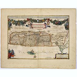
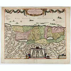
Situs Terrae Promissionis. . .
A truly superb, decorative map with north oriented to the left. It is finely engraved with numerous biblical scenes including the Exodus, the wandering of the Children of...
Date: Amsterdam, 1665
Selling price: ????
Please login to see price!
Sold in 2017
