Browse Listings in Asia
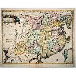
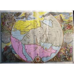
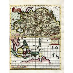
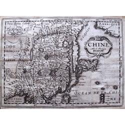
Imperii SINARUM Nova Descriptio
A reduced and much rarer version of Blaeu's map of 1655. Even the cartouche is faithfully copied from the Blaeu map. Adam Olearius was a German scholar and geographer who...
Date: Hamburg, 1696
Selling price: ????
Please login to see price!
Sold in 2020
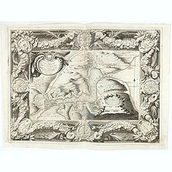
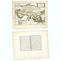
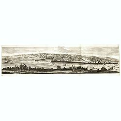
![[2 text pages with views of Fort Zeelandia on Taiwan]](/uploads/cache/83711-250x250.jpg)
[2 text pages with views of Fort Zeelandia on Taiwan]
Each page with a depiction of a sea battle offshore Fort Zeelandia on Taiwan. The "81" page in September 1661. The Siege of Fort Zeelandia of 1661-1662 ended th...
Date: Hamburg, 1696
Selling price: ????
Please login to see price!
Sold in 2020
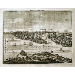
Bosforo tracio, hoggidi Canale di Costantinopoli, descritto dal P. Cosmografo Coronelli secondo le memorie di Monsieur Galland.
Map of The Bosporus, with Istanbul lower left. The map is set in an ornate border.From Coronelli's rare Atlante Veneto, one of the most decorative and ornate of all 17th ...
Date: Venice, 1696
Selling price: ????
Please login to see price!
Sold in 2020
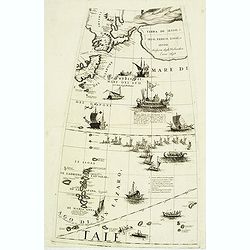
(Globe gore with part of Japan, Kamtchatka, Yedo and Ladrones)
Querter gore from his 110 centimeters in diameter globe of 1688 with part of Japan, eastern Siberia, Yedo and Ladrones. The sea is filled with a large Japanese navel batt...
Date: Venice, 1696 / 1697
Selling price: ????
Please login to see price!
Sold in 2012
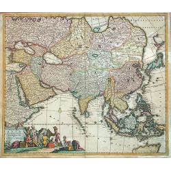
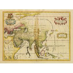
Exactissima Asiae delineatio in praecipuas. . .
This extremely decorative, large map of the Asian continent and East Indies is based on Frederick de Wit's map of 1675. Good details reflect the surveys of Dutch East Ind...
Date: Amsterdam, 1697
Selling price: ????
Please login to see price!
Sold in 2013
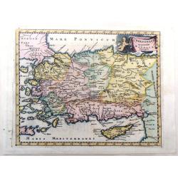
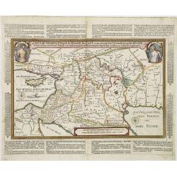
Chersonesi Quae Hodie Natolia Descripto.
Decorative map of Asia Minor extending from Armenia Minor to Hardianopolis and Crete to Cyprus. It was created by Philip Cluverius in 1697.
Date: Leiden, 1697
Selling price: ????
Please login to see price!
Sold in 2018
L'Asie Dressée Sur Divers Relations Par N. de Fer.
An interesting small map of Asia by Nicolas de Fer. From his rare "Petit et Nouveau Atlas". The first edition was published in 1697 and was republished in 1705 ...
Date: Paris, 1697
Selling price: ????
Please login to see price!
Sold in 2016
Asia Antiqua et Nova.
Interesting map of Asia from Philipp Clüver's famous Introductionis in Universam geographicam, first published in Leiden in 1624. Philipp Clüver (1580–1623) was virtu...
Date: Amsterdam, 1697
Selling price: ????
Please login to see price!
Sold in 2017
Asia Antiqua et Nova.
A nice, detailed map of Asia, with a decorative cartouche. Interesting because of its unusual configuration of the Philippines, Japan and Korea. From the eastern Mediterr...
Date: Leiden, 1697
Selling price: ????
Please login to see price!
Sold in 2019
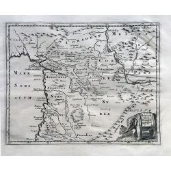
Syriae Sive Soriae Descriptio.
A nice map of ancient Syria, filled with many details of the local topography and place names, and with a decorative elephant title cartouche. Phillip Cluver, latinised a...
Date: Amsterdam, 1697
Selling price: ????
Please login to see price!
Sold in 2023
Nova Tabula India Orientalis Hugo Allard Excudit jnde Kalverstraet inde Werrelt Caert.
Extremely decorative, large, very rare of Africa, Asia and Australia by Hugo Allard. This is the even rarer first state of the map, which appeared around 1697 in Amsterda...
Date: Amsterdam, 1697
Selling price: ????
Please login to see price!
Sold in 2021
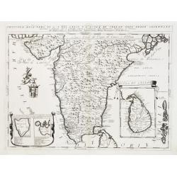
Penisola dell'Indo di qua del Gange, e l isola di Ceilan..
India below the Tropic of Cancer, with an insets of Ceylon and Trincomalee.The remarkable Vincenzo Coronelli (1650-1718), encyclopaedist, geographer, inventor and Doctor ...
Date: Venice 1698
Selling price: ????
Please login to see price!
Sold
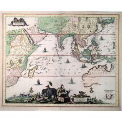
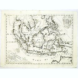
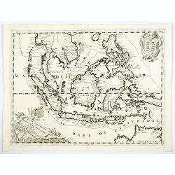
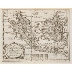
Isole dell'Indie
A beautiful and flamboyantly engraved large-scale map of the East Indies, including the Malay Peninsula, Cambodia, the Philippines and all of Indonesia and the Spice Isla...
Date: Venice 1698
Selling price: ????
Please login to see price!
Sold
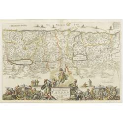
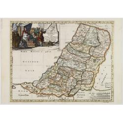
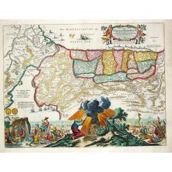
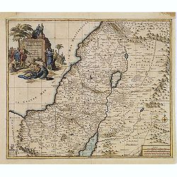
Promised land and Canaan.
Map of Israel/Palestine. The large bottom-cartouche shows the birth, death and resurrection of Christ, and the four evangelists with their symbols.
Date: Dordrecht, 1698
Selling price: ????
Please login to see price!
Sold in 2008
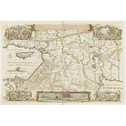
Middle-East.
Map of the middle-East four cartouches show life in, and expulsion out of paradise, another cartouche shows the Noah's Ark.
Date: Dordrecht, 1698
Selling price: ????
Please login to see price!
Sold
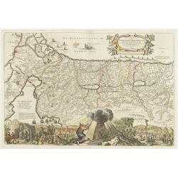
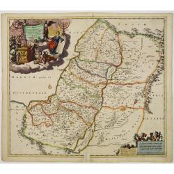
Palestine / Israel.
Map of Palestine and Israel. Large bottom-cartouche shows the 40-years expedition from the Sinai desert to the promised land, and Moses receiving the the tables of the 10...
Date: Dordrecht ,1698
Selling price: ????
Please login to see price!
Sold
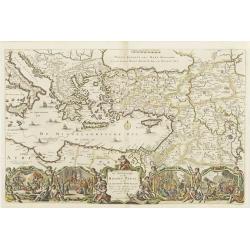
Eastern Mediterranian.
Map of Turkey, Greece, Middle-east, part of Italy and part of north-Africa. A large bottom-cartouche showing scenes from the life and travels of st.Paul.
Date: Dordrecht 1698
Selling price: ????
Please login to see price!
Sold
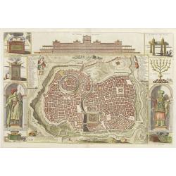
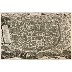
Jerusalem.
Map of Jerusalem and a view on the temple of Salomon. At the sides are cartouches of king Salomon and the high-priest, pictures of the arch of the covenant, tabernacle an...
Date: Dordrecht, 1698
Selling price: ????
Please login to see price!
Sold
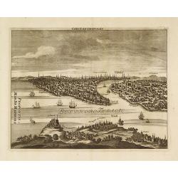
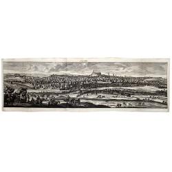
Constantinopolen.
A finely engraved prospect view of Constantinople (Istanbul) from above Scutari.Cornelis de Bruyn (1652-1726) was a Dutch portrait painter and traveler. He painted for so...
Date: Amsterdam, 1698
Selling price: ????
Please login to see price!
Sold in 2020
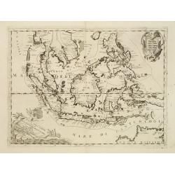
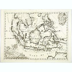
Isole dell'Indie.
A beautiful and flamboyantly engraved large-scale map of the East Indies, including the Malay Peninsula, Cambodia, the Philippines and all of Indonesia and the Spice Isla...
Date: Venice, 1698
Selling price: ????
Please login to see price!
Sold in 2010
Ierusalem.
Panoramic view of Jerusalem as viewed from Mount of Olives with several figures in the foreground. Cornelis de Bruyn (1652-1726) was a painter who traveled through the Ho...
Date: Delft, Henrik van Krooneveld, 1698
Selling price: ????
Please login to see price!
Sold in 2011
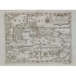
Isole Dell' Indie, diuise in Filippine, Molucche, e della Sonda . . .
A beautiful and flamboyantly engraved large-scale map of the East Indies, including the Malay Peninsula, Cambodia, the Philippines and all of Indonesia and the Spice Isla...
Date: Venice, 1698
Selling price: ????
Please login to see price!
Sold in 2012
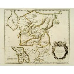
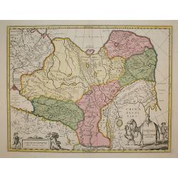
Iunan, Queicheu, e Quangsi Provincie della China . . .
Striking early map of the Chinese provinces of Iunan (Yunan), Queicheu (Guizhou), e Quangsi (Guangxi). With a highly decorative title and mileage-scale cartouches. In top...
Date: Venice, 1698
Selling price: ????
Please login to see price!
Sold in 2012
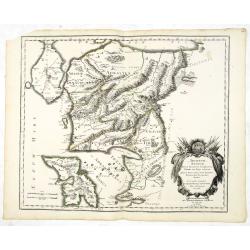
Xansi, e Xensi, provincie della China . . .
A beautiful and flamboyantly engraved large-scale map of Province of Xansi (Shanxi) and Xensi (Shaanxi) including a depiction of the Great Wall and the Deserto de Xamo. T...
Date: Venice, 1698
Selling price: ????
Please login to see price!
Sold in 2012
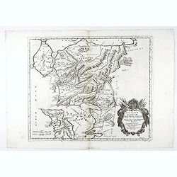
Xantung, e Peking provincie della china. . .
A beautiful map depicting the area of Beijing with decorative title cartouche and scale cartouche. Information about the area at the top of the map.To the right the west ...
Date: Venice, 1698
Selling price: ????
Please login to see price!
Sold in 2012
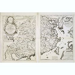
Parte occidentale della China / Parte orientale della China . . .
The two sheet map depicts the eastern part of China with Korea -correctly- as a peninsula. The maps are still on separate uncut sheets, each map measuring 607x450mm., tog...
Date: Venice, 1698
Selling price: ????
Please login to see price!
Sold in 2013
Ierusalem.
Panoramic view of Jerusalem as viewed from Mount of Olives with several figures in the foreground. Cornelis de Bruyn (1652-1726) was a painter who traveled through the Ho...
Date: Delft, Henrik van Krooneveld, 1698
Selling price: ????
Please login to see price!
Sold in 2018
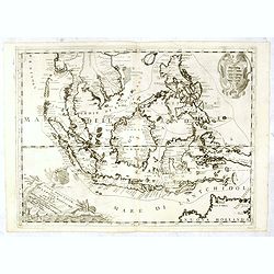
Isole Dell' Indie, diuise in Filippine, Molucche, e della Sonda . . .
A beautiful and flamboyantly engraved large-scale map of the East Indies, including the Malay Peninsula, Cambodia, the Philippines and all of Indonesia and the Spice Isla...
Date: Venice, 1698
Selling price: ????
Please login to see price!
Sold in 2016
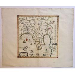
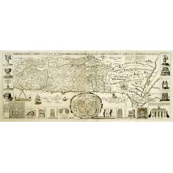
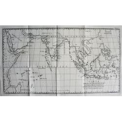
Tab. XI. Asiae, Comprehendens Indiam Extra Gangem.
This wonderful map illustrates the Ptolemaic concept of Malaya and Indochina, labeled 'India Extra Gangem' or 'India beyond the Ganges'. The map shows an oddly shaped Mal...
Date: Utrecht, 1698
Selling price: ????
Please login to see price!
Sold in 2017
Isole Dell' Indie, diuise in Filippine, Molucche, e della Sonda . . .
A beautiful and flamboyantly engraved large-scale map of the East Indies.
Date: Venice, 1698
Selling price: ????
Please login to see price!
Sold in 2018
Isole Dell' Indie, diuise in Filippine, Molucche, e della Sonda . . .
A beautiful and flamboyantly engraved large-scale map of the East Indies, including the Malay Peninsula, Cambodia, the Philippines and all of Indonesia and the Spice Isla...
Date: Venice, 1698
Selling price: ????
Please login to see price!
Sold in 2018
Constantinopolen.
A detailed view of the Bosphorus and Istanbul from "Reizen van Cornelis de Bruyn...". With numerous buildings and sailing ships. Some important points are named...
Date: Amsterdam, 1698
Selling price: ????
Please login to see price!
Sold in 2019
ALEPPO (Syria).
A striking view of the City of Aleppo, from Cornelis De Bruyn's 'Reizen'. De Bruyn (1652- ca 1726 ) was a Dutch portrait painter and traveler, and is remembered chiefly f...
Date: Delft, 1698
Selling price: ????
Please login to see price!
Sold in 2020
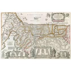
Troianum Regnum.
A fine historical map of part of northwest Anatolia in what is now Turkey, south of the southwest end of the Dardanelles / Hellespont and northwest of Mount Ida with the ...
Date: Paris 1699
Selling price: ????
Please login to see price!
Sold in 2010
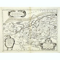
Troianum regnum, novem dinasteias complectens, Priami dum regna Manebant . . .
A fine historical map of part of northwest Anatolia in what is now Turkey, south of the southwest end of the Dardanelles / Hellespont and northwest of Mount Ida with the ...
Date: Paris, 1699
Selling price: ????
Please login to see price!
Sold in 2013
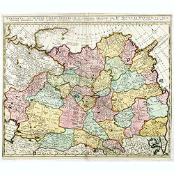
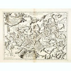
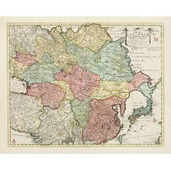
Tartaria, sive magni chami imperium ex credendis. . .
This map is particularly significant for its depiction of Russia, Siberia, and parts of Chinese Tartary, taken from the great six-sheet map by Nicolas Witsen, 1687. The i...
Date: Amsterdam, 1699
Selling price: ????
Please login to see price!
Sold in 2016
Troianum regnum, novem dinasteias complectens, Priami dum regna Manebant . . .
A fine historical map of part of northwest Anatolia in what is now Turkey, south of the southwest end of the Dardanelles / Hellespont and northwest of Mount Ida with the ...
Date: Paris, 1699
Selling price: ????
Please login to see price!
Sold in 2021
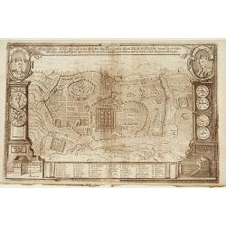
Eigentlicher Situs und Grundt Riss.. Statt Jerusalem..
Uncommon bird's-eye view of ancient Jerusalem. In top left a portrait of King David and upper right a portrait of Salomon. With a numbered key of 52 most important buildi...
Date: Germany 1700
Selling price: ????
Please login to see price!
Sold
Chorographia Terrae Sanctae in Angustiorem..
Rare. Large visually rich map decorated with illustrations of the sacred objects and places of Judaism. In the bottom center is a plan of ancient Jerusalem, and the route...
Date: Amsterdam ca. 1700
Selling price: ????
Please login to see price!
Sold
Chorographia Terrae Sanctae in Angustiorem..
Rare. Large visually rich map decorated with illustrations of the sacred objects and places of Judaism. In the bottom center is a plan of ancient Jerusalem, and the route...
Date: Amsterdam ca. 1700
Selling price: ????
Please login to see price!
Sold
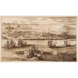
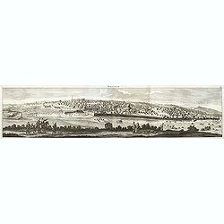
T'Eylandt Formosa.
Scarce panoramic view of "Fort Zeelandia" on the island of Formosa.
Date: Amsterdam 1700
Selling price: ????
Please login to see price!
Sold
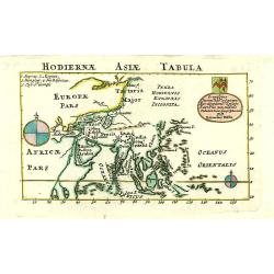
Hodiernae Asiae Tabula.
A boldly engraved map of the East Indies with large compass card and cartouche with a dedication to John Trelawney. The area north of Korea till Nova Zembla left blank an...
Date: London 1700
Selling price: ????
Please login to see price!
Sold
Chorographia Terrae Sanctae in Augustiorem..
Rare. Large visually rich map decorated with illustrations of the sacred objects and places of Judaism. In the bottom center is a plan of ancient Jerusalem, and the route...
Date: Amsterdam, ca.1700
Selling price: ????
Please login to see price!
Sold
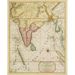
Carte particuliere d'une Partie d'Asie.. Ceylon, Maldives..
Intriguing map of India, Ceylon, Maldives and East Coast of Sumatra, and Malaysia. From Suite du Neptune François, ou Atlas Nouveau des Cartes Marines.From the rare and ...
Date: Amsterdam 1700
Selling price: ????
Please login to see price!
Sold
L'Asie..
Prepared by G. de L'Isle of c. 1700 and published by Louis Renard of Amsterdam.Rare Amsterdam issue.The blank areas between the 'peninsula' of Nouvelle Zemla and the east...
Date: Amsterdam, 1700
Selling price: ????
Please login to see price!
Sold
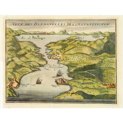
Veue des Dardanelles de Constantinople.
Attractive birds eye view of Hellespont, fortifications and the city of Istanbul in the background.
Date: Paris c.1700
Selling price: ????
Please login to see price!
Sold
Geographiae Sacrae Tabula, in qua Terra Promissa..
Attractive map after N.Sanson\'s folio map of 1662 with decorative cartouche showing the map of Canaan presented to Joshua by his spies. Engraved by A.Winter.First added ...
Date: Halma, Amsterdam, after 1700
Selling price: ????
Please login to see price!
Sold in 2009
Iudea sive Terra Sancta quae Israelitarum..
Rare issue of T. Danckerts attractive map of part of Israel.Decorative title cartouche upper left hand corner.
Date: Amsterdam 1700
Selling price: ????
Please login to see price!
Sold
De Zwarte Zee, eertyts Pontus Euxinus.
Nicolas Sanson (1600-67), ' father of the French cartography' and founder of the Sanson firm. Atlas ' Cartes générales de toutes les parties du Monde', 1658-70 and a po...
Date: Amsterdam, 1700
Selling price: ????
Please login to see price!
Sold
![[No title] [wall map of Southern India, Ceylon and part of Malaysia]](/uploads/cache/22782-250x250.jpg)
[No title] [wall map of Southern India, Ceylon and part of Malaysia]
An attractive large wall map of Southern India, Ceylon and part of Malaysia. Originally in 2 sheets, this is the bottom sheet.With 3 inset plans showing the surroundings ...
Date: Paris, c. 1700
Selling price: ????
Please login to see price!
Sold
Perigrinatie ofte Veertich-jarige Reyse der Kinderen Israels.
Dutch so-called ' Staten' bibles, published between 1637 and c. 1760, contained 5 maps: The World, ' Paradise', The Perigrinations, The Promised Land Canaan, The Travels ...
Date: Amsterdam / Dordrecht, Pieter Keur, Pieter Rotterdam 1700
Selling price: ????
Please login to see price!
Sold in 2008
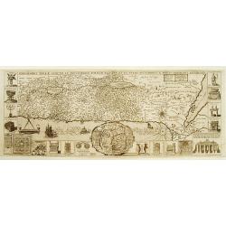
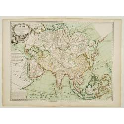
Ancient Asia.
Map of ancient Asia engraved by Michael Burghers of Oxford University. Dedicated to the Duke of Gloucester.With several interesting legends, a legend in the vicinity of t...
Date: Oxford, 1700
Selling price: ????
Please login to see price!
Sold in 2014
Magnae Tartariae Magni Mogolis Imperii Japoniae et Chinae..
The map stretches from the Caspian Sea in the West to Formosa and Japan in the East. Korea rightly correctly depicted as a peninsula. With an over-sized Taiwan. It has be...
Date: London, 1700
Selling price: ????
Please login to see price!
Sold in 2009
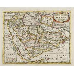
't Steenachtige, Woest, en Gelukkig Arabien.
An attractive map of the Arabian Peninsula from a Dutch text edition. Engraved by A.de Winter.
Date: Amsterdam, 1700
Selling price: ????
Please login to see price!
Sold
ORBIS PER CREATIONEM INSTITUTUS; ORBIS PER DILUVIUM DESTITIUTUS
Attractive and rare map centered on the Garden Eden. Shows the Near East with Holy Land Israel, Syria, Jordania, Palestine, Arabia, Yemen, the Emirates, Egypt, Turkey, C...
Date: Amsterdam, c 1700
Selling price: ????
Please login to see price!
Sold in 2008
Persia sive Sophorum regnum cum Armenia Assyria Mesopotamia et Babylonia.
Uncommon map of the Near East, including Cyprus, Holy Land, Armenia, etc.
Date: Amsterdam, 1700
Selling price: ????
Please login to see price!
Sold in 2008
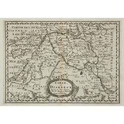
Sorie, et Diarbeck.
An attractive miniature prepared by N.Sanson. Covering the Syrian desert, Lebanon, and the mouth of the Tigris in the Persian Gulf. Including Babylon, Tripoli, Palestine,...
Date: Paris, c.1700
Selling price: ????
Please login to see price!
Sold in 2011
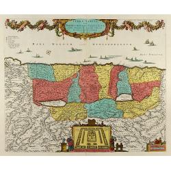
Terra Sancta, sive Promissionis, olim Palestina Recens Delineata, et in Lucem Edita per Nicolaum Visscher Anno 1659
Beautiful hand color copper engraved map of Palestine by N. Visscher issued by P. Schenk in Amsterdam. Oriented to the West. With beautiful cartouches, several ships, a p...
Date: Amsterdam, 1700
Selling price: ????
Please login to see price!
Sold in 2008
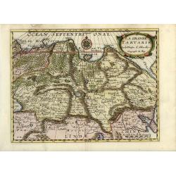
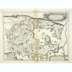
La Grande Tartarie
Attractive map of Siberia, northern China, and Korea, which is shown here as an island. The cities, mountains, forests and rivers are well-detailed. Siberia still reflect...
Date: Amsterdam, 1700
Selling price: ????
Please login to see price!
Sold in 2008
Tartaria sive Magni Chami Imperium
Being one of the most remote regions of Asia, it was among the last to be properly explored and mapped. This map combines the knowledge obtained by the English and Dutch ...
Date: Amsterdam, 1700
Selling price: ????
Please login to see price!
Sold in 2009
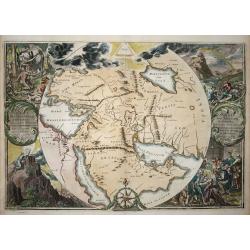
Orbis Per Creationem Institutus.
This is a very unusual map depicting the region from Asia Minor to India and including all of the Arabian Peninsula within a circle. The Garden of Eden is prominently dis...
Date: Amsterdam, 1700
Selling price: ????
Please login to see price!
Sold in 2009
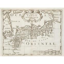
Les Isles du Iapon.
Date: Amsterdam, 1700
Selling price: ????
Please login to see price!
Sold in 2009
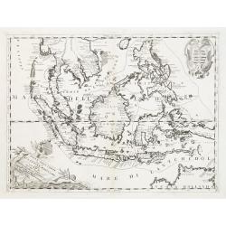
Les Isles de la Sonde entre lesquelles sont Sumatra, Java ?
The title is within a decorative cartouche flanked by swags of fruit. The islands of Sumatra, Java and Borneo in full, together with part of those adjacent and includes t...
Date: Amsterdam, 1700
Selling price: ????
Please login to see price!
Sold in 2010
Les Isles Molucques, Celebes, Gilolo, &c. ?
Shows the islands east of Borneo, up to and including New Guinea. From a pocket-atlas published by F. Halma.
Date: Amsterdam, 1700
Selling price: ????
Please login to see price!
Sold in 2009
Perigrinatie ofte Veertich-Jarige Reyse der Kinderen Israels, ...
Bible map of the Holy Land.
Date: Amsterdam, ca.1700
Selling price: ????
Please login to see price!
Sold in 2010
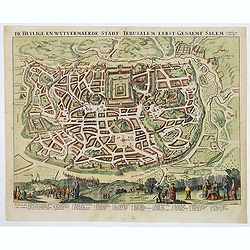
De Heylige wytvermaerde stad Jerusalem eerst genaemt Salem.
Decorative cityplan of Jerusalem.
Date: Amsterdam, c.1700
Selling price: ????
Please login to see price!
Sold in 2010
Utrivso Tartariae & Insularum Indicaru.
Two maps on one sheet. The one on top showing northern Russia in great detail, with many mountains, woods, rivers, and towns shown. The map on the bottom shows Indonesia ...
Date: Munich, c1700
Selling price: ????
Please login to see price!
Sold in 2010
CARTA PARA LA INTELIGENCIA DE LOS ESTABLECIMIENTOS DE LOS PORTUGUESES Y HOLANDESES EN LAS INDIAS ORIENTALES.
SCARCE map of the Indian Ocean and South East Asia. Extends from the East African Coast, Madagascar, and Arabia to Formosa (Taiwan), the Philippines, and New Guinea. Fa...
Date: ca. 1700
Selling price: ????
Please login to see price!
Sold in 2010
Land Tafel darinnen die gegendt des Paradijs das land Canaan. . .
Beautiful and rare map showing the Holy Land, Syria, Cyprus, Iran, Iraq, etc. With inset portraits showing Adam and Eve. Scale in lower part, with little cartouche giving...
Date: Germany, ca. 1700
Selling price: ????
Please login to see price!
Sold in 2010
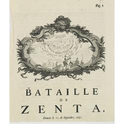
Bataille de Zenta, Donnée le 11 de Septembre 1697.
Decorative etching of the siege by Prince Eugène de Savoie of Zenta in Serbia by the French on 11 September 1697. The town, river Tisza and the Ottoman troupes are shown...
Date: Amsterdam, ca. 1700
Selling price: ????
Please login to see price!
Sold in 2010
Chine.
Scarce and interesting map of China printed from a reworked Cloppenburgh plate. Latin names and hachuring have been burnished from the plate and the original title “Chi...
Date: Amsterdam, 1700
Selling price: ????
Please login to see price!
Sold in 2012
De Heylige en Wytvermaerde Stadt Jerusalem eerst genaemt Salem Genesis 14 Vers 18.
Very attractive bird's-eye view of Jerusalem, showing the city laid out in blocksIn the foreground are shown Christ on the cross at Mount Calvary, and Solomon at Mount Gi...
Date: Amsterdam, c. 1700
Selling price: ????
Please login to see price!
Sold in 2011
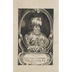
Sulthan Solyman Turckischer Kayser.
Portrait of Kanuni Sultan Süleyman (6 November 1494 – 5/6/7 September 1566) was the tenth and longest-reigning Sultan of the Ottoman Empire, from 1520 to his death in ...
Date: Germany, c. 1700
Selling price: ????
Please login to see price!
Sold in 2011
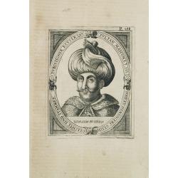
Turckischer Keyser Sultan Mahumet III und XV Osmaniers geschlechts und stammes.
Portrait of Sultan Mahumet III who was born on the 30th of December in 1673. He was intelligent and educated by famous scholars.Sultan Ahmed III acceded the throne after ...
Date: Germany, c.1700
Selling price: ????
Please login to see price!
Sold in 2011
Carte de la TERRE SAINTE..
A fine map of the Holy Land depicting the tribes of Israel. A fine cartouche with Jesus preaching and healing. The scales with a cartographer and his pupil.
Date: Amsterdam, 1700
Selling price: ????
Please login to see price!
Sold in 2014
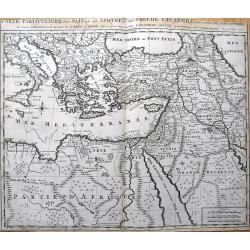
Carte Particuliere des Pais ou Les Apotres ont Preche l'Euan Gile; des Lieux les Plus Renommez de Leurs Voyages, et de la Route de St. Paul a Rome.
Detailed map of the Mediterranean and Middle East, illustrating the travels of St. Paul as he journeyed from Jerusalem to Rome. Very detailed, with numerous place names...
Date: Amsterdam, c1700
Selling price: ????
Please login to see price!
Sold in 2013
De Heylige en Wytvermaerde Stadt Jerusalem eerst genaemt Salem Genesis 14 Vers 18.
Very attractive imaginary bird's-eye of Jerusalem, showing the city laid out in blocksWith 36 principal sites numbered (1-36, A-D) and keyed to a table in lower margin. ...
Date: Amsterdam, c. 1700
Selling price: ????
Please login to see price!
Sold in 2014
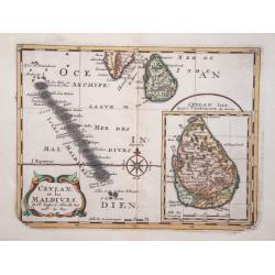
Ceylan, et les Maldives.
Exquisite map of Sri Lanka and the Maldives, with the southern tip of India shown at the top. Sri Lanka is shown in an inset named Ceylan Isle, qui est la Taprobane des A...
Date: Amsterdam 1700
Selling price: ????
Please login to see price!
Sold in 2014
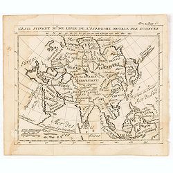
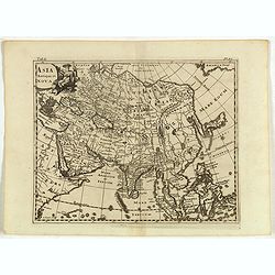
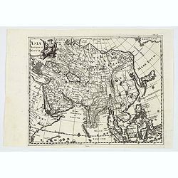
L'Asie suivant Mr. de Lisle de L'Academie royale des sciences.
RARE miniature map of Asia after de L'Isle. The map is of interest for the use of East Sea, the sea between Korea and Japan, here called "Mer Orientale".With Co...
Date: Paris, ca. 1700
Selling price: ????
Please login to see price!
Sold in 2014
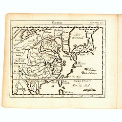
Chine.
RARE miniature map of China, Korea, Japan and Taiwan. The map is of interest for the use of East Sea, the sea between Korea and Japan, here called "Mer Orientale&quo...
Date: Paris, ca. 1700
Selling price: ????
Please login to see price!
Sold in 2014